Area off Georgia coast
Moderator: S2k Moderators
Forum rules

The posts in this forum are NOT official forecasts and should not be used as such. They are just the opinion of the poster and may or may not be backed by sound meteorological data. They are NOT endorsed by any professional institution or STORM2K. For official information, please refer to products from the National Hurricane Center and National Weather Service.
-
OuterBanker
- S2K Supporter

- Posts: 1761
- Joined: Wed Feb 26, 2003 10:53 am
- Location: Nags Head, NC
- Contact:
Area off Georgia coast
Sweet, more potent and better than any canned you'll ever have (whoops wrong subject). Well JB bashers and supporters are going to have fun with this. JB predicted home brew for next week. Diana, Carol, Gaston as examples. Who knows he may be right. Will the bashers give him credit if he's right, we all know what will hapeen if he's wrong. Anyway we can use this as reference next week.
0 likes
Re: Home Brew.
outer banker can you be a little more specific (even if his prediction was general)
late week, early week, tropical storm, hurricane ??
late week, early week, tropical storm, hurricane ??
0 likes
-
OuterBanker
- S2K Supporter
- Posts: 1761
- Joined: Wed Feb 26, 2003 10:53 am
- Location: Nags Head, NC
- Contact:
Re: Home Brew.
Well you have the Canadian on your side http://moe.met.fsu.edu/cgi-bin/cmctc2.c ... hour=138hr, for what that is worth.
0 likes
-
storms in NC

- S2K Supporter
- Posts: 2338
- Joined: Thu Jul 28, 2005 2:58 pm
- Location: Wallace,NC 40 miles NE of Wilm
- Contact:
-
flwxwatcher
- Category 4

- Posts: 926
- Joined: Wed May 16, 2007 3:35 pm
- Location: Central Florida
Re: Home Brew.
Todays The 12Z GFS is hinting at something forming of the SE Coast this week and in another thread WXMAN57 also mentioned he thought the area North of the Bahamas was an area to watch for development this week.
http://www.nco.ncep.noaa.gov/pmb/nwprod ... /fpc.shtml
http://www.nco.ncep.noaa.gov/pmb/nwprod ... /fpc.shtml
0 likes
-
Emmett_Brown

- Category 5

- Posts: 1433
- Joined: Wed Aug 24, 2005 9:10 pm
- Location: Sarasota FL
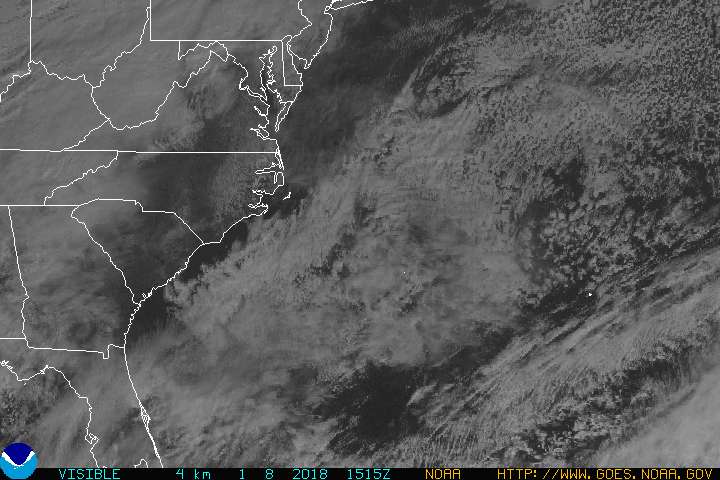
Interesting... you can see a low pressure area along the old frontal boundry just coming off the SE coast. This could be the start of our home brew system:
http://www.goes.noaa.gov/HURRLOOPS/huecvs.html
Has a long way to go to get organized, but here in NE FL, the sky has that look to it... puffy cumulus, with small passsing showers, and winds just a touch breezier than they have been. It is hot here, but the more untable air is putting a dent in the hazy hot conditions that we have been experiencing.
This 48 hour GFS surface mapdoesnt show a low, but it does show a ridge to the north that might keep a low trapped in place for a while off the SE coast:
http://weather.unisys.com/hurricane/slp_48.gif
There will also be a big high aloft, which is generally favorable for development:
http://weather.unisys.com/hurricane/3hh_48.gif
To summarize: It is early, but the conditions look favorable, and the mechanism exists in the form of the frontal low for TC development in the coming days. EC FL to NC should watch it IMO.
0 likes
-
Ed Mahmoud
Re:
x-y-no wrote:JB has been looking at the Canadian model, maybe. It blows up a strong hurricane east of Florida and takes it into the Carolinas under a rebuilding ridge.
It's certainly a possibility.
Bastardi has been saying the pattern would support something trying to get going there for several days, even before 95L and its cousin 96L, and when they were moving off, he thought another one might try to get going.
Even Bastardi calls the CMC 'the crazy uncle'.
0 likes
-
x-y-no

- Category 5
- Posts: 8359
- Age: 65
- Joined: Wed Aug 11, 2004 12:14 pm
- Location: Fort Lauderdale, FL
Re: Re:
Ed Mahmoud wrote:x-y-no wrote:JB has been looking at the Canadian model, maybe. It blows up a strong hurricane east of Florida and takes it into the Carolinas under a rebuilding ridge.
It's certainly a possibility.
Bastardi has been saying the pattern would support something trying to get going there for several days, even before 95L and its cousin 96L, and when they were moving off, he thought another one might try to get going.
Even Bastardi calls the CMC 'the crazy uncle'.
Yeah, I guess I was being a bit unfair there. I recall someone mentioning him saying something about an EC home-brew system several days ago.
0 likes
seems like there is a high amount of uncertainty based on reading the NOAA disco's for savannah and jacksonville regarding how this trough/ or low will develop and it's strength although it apparently would develop sunday and move out east into atlantic tuesday based n prelim's.
now wether it steers felix more northward or 98L or neither is yet to be seen
now wether it steers felix more northward or 98L or neither is yet to be seen
0 likes

-
hurricanetrack

- HurricaneTrack.com
- Posts: 1781
- Joined: Tue Dec 02, 2003 10:46 pm
- Location: Wilmington, NC
- Contact:
Hey- low pressure is easily seen on radar offshore SC/GA border:
http://radar.weather.gov/radar.php?rid= ... 1&loop=yes
http://radar.weather.gov/radar.php?rid= ... 1&loop=yes
0 likes
-
vacanechaser

- Category 5
- Posts: 1461
- Joined: Wed Dec 03, 2003 9:34 pm
- Location: Portsmouth, Va
- Contact:
Re:
hurricanetrack wrote:Hey- low pressure is easily seen on radar offshore SC/GA border:
http://radar.weather.gov/radar.php?rid= ... 1&loop=yes
certainly something going on there for sure... this could very well be on its way... water temps are plenty warm.. need to watch it closely in the next few days
Jesse V. Bass III
http://www.vastormphoto.com
Hurricaner Intercept Research Team
0 likes
-
flwxwatcher
- Category 4
- Posts: 926
- Joined: Wed May 16, 2007 3:35 pm
- Location: Central Florida
Re: Home Brew.
Yes, this area is starting to look alot more interesting and the 0Z GFS is trying to develope something in this area now.
http://www.nco.ncep.noaa.gov/pmb/nwprod ... /fpc.shtml
http://www.nco.ncep.noaa.gov/pmb/nwprod ... /fpc.shtml
0 likes

Re: Home Brew.
Good shot of it on radar here: http://www.intellicast.com/National/Radar/Current.aspx?location=USFL0479&animate=true
0 likes
-
Emmett_Brown
- Category 5
- Posts: 1433
- Joined: Wed Aug 24, 2005 9:10 pm
- Location: Sarasota FL
Our system is looking better on vis:
http://www.goes.noaa.gov/GIFS/ECSTVS.JPG
You can clearly see a circulation. Not sure if it is tropical, but it is a low.
http://www.goes.noaa.gov/GIFS/ECSTVS.JPG
You can clearly see a circulation. Not sure if it is tropical, but it is a low.
0 likes
-
Tampa Bay Hurricane

- Category 5
- Posts: 5597
- Age: 38
- Joined: Fri Jul 22, 2005 7:54 pm
- Location: St. Petersburg, FL
-
storms in NC
- S2K Supporter
- Posts: 2338
- Joined: Thu Jul 28, 2005 2:58 pm
- Location: Wallace,NC 40 miles NE of Wilm
- Contact:
-
Tampa Bay Hurricane
- Category 5
- Posts: 5597
- Age: 38
- Joined: Fri Jul 22, 2005 7:54 pm
- Location: St. Petersburg, FL
Re: Home Brew.
Very strong ridge building in so it would likely impact
the SE coast quite a bit...Looks like some heavy rain
near georgia/carolinas now...
the SE coast quite a bit...Looks like some heavy rain
near georgia/carolinas now...
0 likes
Who is online
Users browsing this forum: IsabelaWeather and 50 guests