Invest 98L,Central Atlantic
Moderator: S2k Moderators
Re: Invest 98L,Central Atlantic-Discussions-Analysis & Imagery
I have a gut feeling (and its just that) that when this storm hits higher sea surface temperatures and lighter shear tomorrow and Monday, it will start taking off.
0 likes
- CourierPR
- Category 5

- Posts: 1336
- Age: 72
- Joined: Tue Aug 31, 2004 7:53 pm
- Location: Pompano Beach, Florida
Re: Invest 98L,Central Atlantic-Discussions-Analysis & Imagery
This system appears to be getting healthier right now.
0 likes
- Blown Away
- S2K Supporter

- Posts: 10253
- Joined: Wed May 26, 2004 6:17 am
Re: Invest 98L,Central Atlantic-Discussions-Analysis & Imagery
canegrl04 wrote:Out of all those models depicted,the GFDL and NHC have more reliability than the others.They are showing a path that would eventually take it into the GOM
Not sure how you can conclude GOM with these model runs, they barely make it to the islands??
0 likes
Re: Invest 98L,Central Atlantic-Discussions-Analysis & Imagery
Blown_away wrote:canegrl04 wrote:Out of all those models depicted,the GFDL and NHC have more reliability than the others.They are showing a path that would eventually take it into the GOM
Not sure how you can conclude GOM with these model runs, they barely make it to the islands??
Has to be the "gut feeling" that seems to guide many on this forum.
0 likes
- HURAKAN
- Professional-Met

- Posts: 46084
- Age: 39
- Joined: Thu May 20, 2004 4:34 pm
- Location: Key West, FL
- Contact:
A "gut feeling" mostly means "where I want the system to go." Many here like me say they don't want to see a hurricane but would love to have the experience. The problem is what comes after.
If you pay attention to the chatter when a storm forms, if a person lives in the gulf coast, he/she says it will hit the gulf coast, if a person lives in Florida, the storm will hit Florida, and so on. This mostly comes from people like me that never been in a serious hurricane before.
If you pay attention to the chatter when a storm forms, if a person lives in the gulf coast, he/she says it will hit the gulf coast, if a person lives in Florida, the storm will hit Florida, and so on. This mostly comes from people like me that never been in a serious hurricane before.
0 likes
- CourierPR
- Category 5

- Posts: 1336
- Age: 72
- Joined: Tue Aug 31, 2004 7:53 pm
- Location: Pompano Beach, Florida
Re: Invest 98L,Central Atlantic-Discussions-Analysis & Imagery
My gut feeling tells me that in five days there may be complications in the forecast tracks for Felix and L98
0 likes
- HURAKAN
- Professional-Met

- Posts: 46084
- Age: 39
- Joined: Thu May 20, 2004 4:34 pm
- Location: Key West, FL
- Contact:
Re: Invest 98L,Central Atlantic-Discussions-Analysis & Imagery
CourierPR wrote:My gut feeling tells me that in five days there may be complications in the forecast tracks for Felix and L98
The NHC is informing that Félix is already asking for a private track to avoid complication from amateurs like 98L!!!
0 likes
Re: Invest 98L,Central Atlantic-Discussions-Analysis & Imagery
000
ABNT20 KNHC 012117
TWOAT
TROPICAL WEATHER OUTLOOK
NWS TPC/NATIONAL HURRICANE CENTER MIAMI FL
530 PM EDT SAT SEP 1 2007
A STRONG TROPICAL WAVE LOCATED ABOUT MIDWAY BETWEEN AFRICA AND THE
LESSER ANTILLES IS MOVING WESTWARD AT 15 TO 20 MPH. THE ASSOCIATED
SHOWER ACTIVITY HAS INCREASED THIS AFTERNOON...AND THE SYSTEM COULD
BECOME A TROPICAL DEPRESSION DURING THE NEXT DAY OR TWO.
FORECASTER BEVEN
0 likes
Re: Invest 98L,Central Atlantic-Discussions-Analysis & Imagery
000
AXNT20 KNHC 011753
TWDAT
TROPICAL WEATHER DISCUSSION
NWS TPC/NATIONAL HURRICANE CENTER MIAMI FL
205 PM EDT SAT SEP 1 2007
WELL DEFINED TROPICAL WAVE IS TILTED ALONG 19N34W 6N36W MOVING W
15 KT. A 1009 MB LOW SITS ALONG THIS WAVE AXIS NEAR 13N36W. VIS
IMAGES SHOW THE LOW-LEVEL CENTER EXPOSED TO THE E OF SCATTERED
MODERATE CONVECTION LOCATED WITHIN 300 NM TO THE W OF THE
CENTER. THIS WAVE IS OBVIOUSLY FEELING THE EFFECTS OF ELY SHEAR
PRODUCED BY A STRONG UPPER HIGH CENTERED TO THE N. FURTHER
DEVELOPMENT IS POSSIBLE AS THE SYSTEM MOVES W INTO A MORE
FAVORABLE ENVIRONMENT OVER THE NEXT DAY OR TWO. IT IS NOTABLE
THAT THIS WAVE IS PRODUCING A LARGE PERTURBATION IN THE ITCZ
ACROSS A RATHER LARGE AREA
$$
CANGIALOSI
0 likes
Re: Invest 98L,Central Atlantic-Discussions-Analysis & Imagery
gerrit wrote:000
AXNT20 KNHC 011753
TWDAT
TROPICAL WEATHER DISCUSSION
NWS TPC/NATIONAL HURRICANE CENTER MIAMI FL
205 PM EDT SAT SEP 1 2007
WELL DEFINED TROPICAL WAVE IS TILTED ALONG 19N34W 6N36W MOVING W
15 KT. A 1009 MB LOW SITS ALONG THIS WAVE AXIS NEAR 13N36W. VIS
IMAGES SHOW THE LOW-LEVEL CENTER EXPOSED TO THE E OF SCATTERED
MODERATE CONVECTION LOCATED WITHIN 300 NM TO THE W OF THE
CENTER. THIS WAVE IS OBVIOUSLY FEELING THE EFFECTS OF ELY SHEAR
PRODUCED BY A STRONG UPPER HIGH CENTERED TO THE N. FURTHER
DEVELOPMENT IS POSSIBLE AS THE SYSTEM MOVES W INTO A MORE
FAVORABLE ENVIRONMENT OVER THE NEXT DAY OR TWO. IT IS NOTABLE
THAT THIS WAVE IS PRODUCING A LARGE PERTURBATION IN THE ITCZ
ACROSS A RATHER LARGE AREA
$$
CANGIALOSI
SO what implications does this have for Felix?
0 likes
Re: Invest 98L,Central Atlantic-Discussions-Analysis & Imagery
canegrl04 wrote:SO what implications does this have for Felix?
Nothing as far as I can see..
0 likes
Re: Invest 98L,Central Atlantic-Discussions-Analysis & Imagery
gerrit wrote:canegrl04 wrote:SO what implications does this have for Felix?
Nothing as far as I can see..
I was just wondering about what that,and CourierPR had to say about complications for Felix track 5 days out
0 likes
Re: Invest 98L,Central Atlantic-Discussions-Analysis & Imagery
Cycloneye,it seems to me that forecasters in the weather bureau of San Juan,are "addicted "to the GFS models. When Gfs runs developped something,their bulletins give a good part of that! Now that Gfs see nothing strong with the wave thy only talk of a wave in the future.... Am'i right? Other wise,i really appreciate their exellent job,very accurate.
0 likes
- cycloneye
- Admin

- Posts: 149276
- Age: 69
- Joined: Thu Oct 10, 2002 10:54 am
- Location: San Juan, Puerto Rico
Re: Invest 98L,Central Atlantic-Discussions-Analysis & Imagery
HUC wrote:Cycloneye,it seems to me that forecasters in the weather bureau of San Juan,are "addicted "to the GFS models. When Gfs runs developped something,their bulletins give a good part of that! Now that Gfs see nothing strong with the wave thy only talk of a wave in the future.... Am'i right? Other wise,i really appreciate their exellent job,very accurate.
Yes that is true.But also depends on who is the forecaster in the distint shifts.I really like one of them Snell who does extensive discussions that talk about all the factors and posibbilities in a week ahead.I hope that when this is a TD all the shifts forecasters put meat to the discussions about this system that In my view is going to be the biggest threat of the season for the NE Caribbean.
0 likes
Re: Invest 98L,Central Atlantic-Discussions-Analysis & Imagery
Tnank's for your reply;i think also that this system is a potential big threat for the NE carriben,or perhaps the central chain!! The High is so strong....
0 likes
Re: Invest 98L,Central Atlantic-Discussions-Analysis & Imagery
Question: What affect will Felix have on this system, in terms of sea-surface temps and flooding?
0 likes
- HurricaneMaster_PR
- Category 2

- Posts: 795
- Joined: Tue Jul 22, 2003 6:23 pm
- Location: San Juan, Puerto Rico
Re: Invest 98L,Central Atlantic-Discussions-Analysis & Imagery
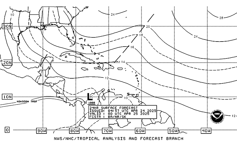
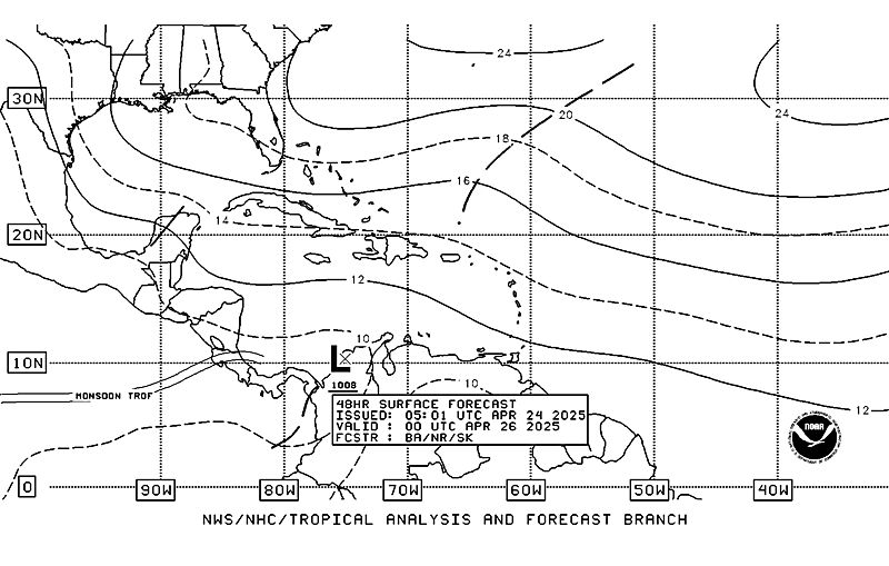
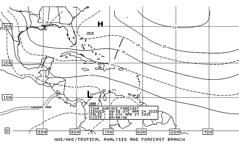
TAFB=Possible Tropical Cyclone within the next 24 hours..


Last edited by HurricaneMaster_PR on Sat Sep 01, 2007 7:14 pm, edited 1 time in total.
0 likes
- cycloneye
- Admin

- Posts: 149276
- Age: 69
- Joined: Thu Oct 10, 2002 10:54 am
- Location: San Juan, Puerto Rico
Re: Invest 98L,Central Atlantic-Discussions-Analysis & Imagery
A STRONG TROPICAL WAVE IS ALONG 36W...MIDWAY BETWEEN AFRICA AND
THE LESSER ANTILLES...S OF 18N MOVING W NEAR 15 KT. A 1009 MB
LOW IS ALONG THE WAVE AXIS NEAR 13N36W. THE ASSOCIATED SHOWER
ACTIVITY HAS INCREASED AND THE SYSTEM COULD BECOME A TROPICAL
DEPRESSION DURING THE NEXT DAY OR TWO. SCATTERED MODERATE
CONVECTION IS FROM 12N-15N BETWEEN 37W-41W...DISPLACED TO THE W
OF THE EXPOSED CENTER WITH ABOUT 20 KT OF ELY SHEAR OVER THE
SYSTEM AS DEPICTED BY THE LATEST UW-CIMSS SHEAR ANALYSIS.
8 PM Special Feature discussion about 98L.
0 likes
-
Derek Ortt
Who is online
Users browsing this forum: No registered users and 75 guests


