Area off Georgia coast
Moderator: S2k Moderators
Forum rules

The posts in this forum are NOT official forecasts and should not be used as such. They are just the opinion of the poster and may or may not be backed by sound meteorological data. They are NOT endorsed by any professional institution or STORM2K. For official information, please refer to products from the National Hurricane Center and National Weather Service.
-
storms in NC

- S2K Supporter

- Posts: 2338
- Joined: Thu Jul 28, 2005 2:58 pm
- Location: Wallace,NC 40 miles NE of Wilm
- Contact:

Re: Home Brew.
A very soggy weekend here! Tybee Island and Wilmington Island (off of Savannah's coast) have received over a foot of rain this weekend!
0 likes
-
HURAKAN

- Professional-Met

- Posts: 46086
- Age: 38
- Joined: Thu May 20, 2004 4:34 pm
- Location: Key West, FL
- Contact:
Re: Home Brew.
466
ABNT20 KNHC 021513
TWOAT
TROPICAL WEATHER OUTLOOK
NWS TPC/NATIONAL HURRICANE CENTER MIAMI FL
1130 AM EDT SUN SEP 2 2007
FOR THE NORTH ATLANTIC...CARIBBEAN SEA AND THE GULF OF MEXICO...
THE NATIONAL HURRICANE CENTER IS ISSUING ADVISORIES ON HURRICANE
FELIX...LOCATED ABOUT 50 MILES NORTH OF ARUBA.
AN AREA OF LOW PRESSURE...ASSOCIATED WITH A TROPICAL WAVE...IS
LOCATED ABOUT MIDWAY BETWEEN AFRICA AND THE LESSER ANTILLES. THIS
SYSTEM IS EXPECTED TO MOVE WESTWARD NEAR 10 MPH FOR THE NEXT DAY OR
SO. THE ASSOCIATED SHOWER ACTIVITY IS LIMITED AND UPPER-LEVEL
WINDS ARE UNFAVORABLE FOR SIGNIFICANT DEVELOPMENT AT THIS TIME.
HOWEVER...THE CIRCULATION IS WELL-DEFINED AND THERE IS STILL SOME
POTENTIAL FOR THIS SYSTEM TO BECOME A TROPICAL DEPRESSION DURING
THE NEXT COUPLE OF DAYS.
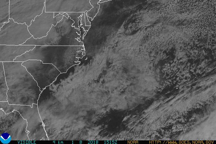
AN AREA OF CLOUDINESS AND SHOWERS JUST TO THE EAST OF THE GEORGIA
COAST IS ASSOCIATED WITH A DECAYING FRONTAL ZONE. THIS SYSTEM HAS
SOME POTENTIAL FOR TROPICAL DEVELOPMENT OVER THE NEXT DAY OR TWO AS
IT DRIFTS GENERALLY EASTWARD.
ELSEWHERE...TROPICAL CYCLONE FORMATION IS NOT EXPECTED DURING THE
NEXT 48 HOURS.
$$
FORECASTER PASCH/RHOME
ABNT20 KNHC 021513
TWOAT
TROPICAL WEATHER OUTLOOK
NWS TPC/NATIONAL HURRICANE CENTER MIAMI FL
1130 AM EDT SUN SEP 2 2007
FOR THE NORTH ATLANTIC...CARIBBEAN SEA AND THE GULF OF MEXICO...
THE NATIONAL HURRICANE CENTER IS ISSUING ADVISORIES ON HURRICANE
FELIX...LOCATED ABOUT 50 MILES NORTH OF ARUBA.
AN AREA OF LOW PRESSURE...ASSOCIATED WITH A TROPICAL WAVE...IS
LOCATED ABOUT MIDWAY BETWEEN AFRICA AND THE LESSER ANTILLES. THIS
SYSTEM IS EXPECTED TO MOVE WESTWARD NEAR 10 MPH FOR THE NEXT DAY OR
SO. THE ASSOCIATED SHOWER ACTIVITY IS LIMITED AND UPPER-LEVEL
WINDS ARE UNFAVORABLE FOR SIGNIFICANT DEVELOPMENT AT THIS TIME.
HOWEVER...THE CIRCULATION IS WELL-DEFINED AND THERE IS STILL SOME
POTENTIAL FOR THIS SYSTEM TO BECOME A TROPICAL DEPRESSION DURING
THE NEXT COUPLE OF DAYS.
AN AREA OF CLOUDINESS AND SHOWERS JUST TO THE EAST OF THE GEORGIA
COAST IS ASSOCIATED WITH A DECAYING FRONTAL ZONE. THIS SYSTEM HAS
SOME POTENTIAL FOR TROPICAL DEVELOPMENT OVER THE NEXT DAY OR TWO AS
IT DRIFTS GENERALLY EASTWARD.
ELSEWHERE...TROPICAL CYCLONE FORMATION IS NOT EXPECTED DURING THE
NEXT 48 HOURS.
$$
FORECASTER PASCH/RHOME
0 likes


-
ConvergenceZone
.gif)
- Category 5

- Posts: 5241
- Joined: Fri Jul 29, 2005 1:40 am
- Location: Northern California
-
Tampa Bay Hurricane

- Category 5
- Posts: 5598
- Age: 38
- Joined: Fri Jul 22, 2005 7:54 pm
- Location: St. Petersburg, FL
Re:
ConvergenceZone wrote:question about this. It says this is scheduled to drift eastward, but isn't that the exact opposite direction tropical storms usually move this low in latitude?? Would it change direction at some point?
The ridge is forecasted to build in strong to push felix,
so a ridge might push this westward back towards the
SE coast somewhere.
0 likes
-
hurricanetrack

- HurricaneTrack.com
- Posts: 1781
- Joined: Tue Dec 02, 2003 10:46 pm
- Location: Wilmington, NC
- Contact:
Re: Area off Georgia coast
I actually hope this can move up towards Wilmington, we really need the rain up here..hard to believe how dry it's been this summer!
0 likes

Re: Area off Georgia coast
I feel that there is a good chance that something tropical will eventually develop from this system. I'm NOT saying this because I'm from GA and it is very close to GA now as I have no good feel for where it would move if it were to develop. Even if it were to develop, it could easily just stay offshore the U.S. and never come back or, IF it were to come back to the U.S., it could hit just about anywhere on the east coast...i.e., potential GA tropical hit chance low as of now.
I feel it has a good chance to develop because it is a system that has produced TREMENDOUS amounts of rainfall in parts of coastal GA/SC and is very slowly moving offshore during the heart of the hurricane season over mostly above average SST's, there's no real strong shear expected in the vicinity for awhile from what I've seen (although shear forecasts often wrong), there's lots of convection currently in a fairly tight area offshore, and there are model forecasts of moderate surface high pressure (~1025 mb) to the north during much of the upcoming period through Friday with no major sweeping trough expected.
My feeling is that its best chance to "escape" is Tuesday. Otherwise, IF it is still hanging around fairly close to the SE coast as of Wed. (say west of ~72 W), I would expect it to get "trapped" through at least Friday and thus become a potential threat to somewhere on the east coast for late week as at least some westward component of motion would seem likely during much of the Wed.-Fri period imho based on model forecasts.
Any south component of motion between now and Tue. would seem to me to lessen the chance to escape from near the U.S. on Tuesday as it would move it further south of the trough expected to cross the NE US. Also, it would seem to lessen shear per shear forecasts (fwiw). On the other hand, the more it could drift eastward by late Tue., the better chance that the Tue. trough would be enough to get it away from the U.S. for good. A NE drift would seem to be the best bet to get it away, whereas only a very slight east drift or worse, a slow ESE or SE drift, would increase the chance for the trapping scenario imho. A S drift may not allow it much chance to develop since it may be too close to shore, but it would almost certainly be trapped. Model consensus is pretty strong on a slow mainly eastward drift through late Tue./early Wed. but no further east than ~72-75W and near 30N. Subsequently, a drift back toward the coast with mainly westward motion seems to be favored by the mods. So, I'm thinking that this is the most likely scenario, especially if it doesn't develop too much prior to then. Nevertheless, I still think an escape on Tuesday is a decent possibility. Also, it is possible that New England rather than the SE US becomes the prime target of this system.
0 likes
Re: Area off Georgia coast
WXMAN57 i would like your opinon as to the potential for this system
earlier you mentioned you concured w/ "JB" as to tropical potential in this area
what are you current thoughts on this feature
greatly appreciated
earlier you mentioned you concured w/ "JB" as to tropical potential in this area
what are you current thoughts on this feature
greatly appreciated
0 likes
Re: Area off Georgia coast
Just from taking a quik look can see at least some mid level turning off radar and satellite. Hard to tell if/where a consolidated lower level area is though. maybe a bit broad and elongated. Seems like something to keep an eye on.
0 likes
-
HURAKAN
- Professional-Met
- Posts: 46086
- Age: 38
- Joined: Thu May 20, 2004 4:34 pm
- Location: Key West, FL
- Contact:
TWD 205:
ATLANTIC OCEAN...
A SLOW MOVING FRONTAL ZONE STRETCHES E-W ALONG OUR N BORDER FROM
S OF BERMUDA TO THE NE FLORIDA COAST. DOPPLER RADAR SHOWS SOME
ROTATION TO THE SCATTERED SHOWER AND TSTM ACTIVITY OFF THE
GEORGIA COAST FROM 30N-32N BETWEEN 79W-81W. THIS AREA WILL BE
MONITORED FOR TROPICAL DEVELOPMENT AS IT DRIFTS EWD
0 likes
-
Epsilon_Fan

- Category 1

- Posts: 353
- Joined: Fri Jan 13, 2006 1:03 pm
- Location: Charleston, SC
-
vacanechaser

- Category 5
- Posts: 1461
- Joined: Wed Dec 03, 2003 9:34 pm
- Location: Portsmouth, Va
- Contact:
Re: Area off Georgia coast
seems to be at least two areas spining.. could just be elongated.. certainly something to watch...
Jesse V. Bass III
http://www.vastormphoto.com
Hurricane Intercept Research Team
Jesse V. Bass III
http://www.vastormphoto.com
Hurricane Intercept Research Team
0 likes

Re: Area off Georgia coast
I expect this low off the Carolinas will be an Invest as early as tomorrow.
0 likes

-
vacanechaser
- Category 5
- Posts: 1461
- Joined: Wed Dec 03, 2003 9:34 pm
- Location: Portsmouth, Va
- Contact:
Re: Area off Georgia coast
looks and sounds a bit like diana in 84.... here is a link to the archive of that storm... old frontal boundary, and the cold pocket aloft to the south... in WV imagery you can see a big upper low passing over florida from the bahamas... sounds simalar..
http://www.nhc.noaa.gov/archive/storm_w ... lim/diana/
Jesse V. Bass III
http://www.vastormphoto.com
Hurricane Intercept Research Team
http://www.nhc.noaa.gov/archive/storm_w ... lim/diana/
Jesse V. Bass III
http://www.vastormphoto.com
Hurricane Intercept Research Team
0 likes
Who is online
Users browsing this forum: Hurricanehink and 46 guests