Invest 99L:Off E Coast-Discussions
Moderator: S2k Moderators
-
GeneratorPower

- S2K Supporter

- Posts: 1648
- Age: 46
- Joined: Sun Dec 18, 2005 11:48 pm
- Location: Huntsville, AL

0430UTC High Seas Forecast
972
FZNT02 KNHC 050332
HSFAT2
HIGH SEAS FORECAST
NWS TPC/NATIONAL HURRICANE CENTER MIAMI FL
0430 UTC WED SEP 05 2007
SUPERSEDED BY NEXT ISSUANCE IN 6 HOURS
SECURITE
ATLANTIC FROM 7N TO 31N W OF 35W INCLUDING CARIBBEAN SEA AND
GULF OF MEXICO
SYNOPSIS VALID 0000 UTC WED SEP 05
24 HOUR FORECAST VALID 0000 UTC THU SEP 06
48 HOUR FORECAST VALID 0000 UTC FRI SEP 07
.WARNINGS.
...TROPICAL STORM WARNING...
.TROPICAL STORM FELIX NEAR 14.1N 85.7W 987 MB AT 0300 UTC SEP 05
MOVING W OR 265 DEG AT 10 KT. MAXIMUM SUSTAINED WINDS 45 KT
GUSTS 55 KT. TROPICAL STORM FORCE WINDS WITHIN 60 NM N
SEMICIRCLE AND 25 NM S SEMICIRCLE.
.12 HOUR FORECAST TROPICAL DEPRESSION FELIX INLAND NEAR 14.1N
87.1W. MAXIMUM SUSTAINED WINDS 30 KT GUSTS 40 KT.
.24 HOUR FORECAST TROPICAL DEPRESSION FELIX INLAND NEAR 14.3N
89.0W. MAXIMUM SUSTAINED WINDS 20 KT GUSTS 25 KT.
.36 HOUR FORECAST ...DISSIPATED.
.SYNOPSIS AND FORECAST.
.ATLC LOW 29N74W 1008 MB MOVING E 10 KT. OVER FORECAST WATERS
WITHIN 210 NM OF LOW OVER E SEMICIRCLE AND NW QUADRANT WINDS 20
TO 30 KT SEAS TO 10 FT.
.24 HOUR FORECAST LOW...POSSIBLE TROPICAL CYCLONE...30N71W 1008
MB. LITTLE CHANGE IN WINDS OR SEAS.
.48 HOUR FORECAST LOW...POSSIBLE TROPICAL CYCLONE...29N71W 1006
MB. LITTLE CHANGE IN WINDS OR SEAS.
.ATLC FROM 17N TO 25N E OF 42W NE WINDS TO 20 KT SEAS TO 8 FT.
.24 HOUR FORECAST FROM 18N TO 25N E OF 45W NE TO E WINDS 20 KT
SEAS TO 8 FT.
.48 HOUR FORECAST FROM 18N TO 24N E OF 50W NE TO E WINDS 20 KT
SEAS TO 8 FT.
.CARIBBEAN...EXCEPT AS NOTED IN FELIX WARNING...ELSEWHERE S OF
18N W OF 82W E TO SE WINDS 20 TO 30 KT SEAS 8 TO 11 FT.
.24 HOUR FORECAST...EXCEPT AS NOTED IN FELIX WARNING...
ELSEWHERE FROM 16N TO 18N W OF 85W E TO SE WINDS 20 KT SEAS TO
8 FT.
.36 HOUR FORECAST WIND LESS THAN 20 KT SEAS LESS THAN 8 FT.
.CARIBBEAN FROM 12N TO 16N BETWEEN 68W AND 75W E WINDS 20 KT
SEAS TO 8 FT.
.24 HOUR FORECAST FROM 12N TO 15N BETWEEN 67W AND 73W E WINDS TO
20 KT SEAS LESS THAN 8 FT.
.48 HOUR FORECAST LITTLE CHANGE.
.REMAINDER OF AREA WINDS LESS THAN 20 KT SEAS LESS THAN 8 FT.
$$
FORECASTER COBB
TROPICAL PREDICTION CENTER
TROPICAL ANALYSIS AND FORECAST BRANCH
0 likes
-
brunota2003

- S2K Supporter
- Posts: 9476
- Age: 35
- Joined: Sat Jul 30, 2005 9:56 pm
- Location: Stanton, KY...formerly Havelock, NC
- Contact:
The TWO better have some good info in it...if its a repeat of the 530 pm one, I might get mad...over an hour delayed and counting, wonder if they are having some type of server problem?
EDIT: I'm seeing the "Update" thing on their front page updating every few minutes or so...wonder what they are posting?
EDIT: I'm seeing the "Update" thing on their front page updating every few minutes or so...wonder what they are posting?
Last edited by brunota2003 on Tue Sep 04, 2007 10:36 pm, edited 1 time in total.
0 likes
-
cheezyWXguy

- Category 5

- Posts: 6282
- Joined: Mon Feb 13, 2006 12:29 am
- Location: Dallas, TX
-
Matt-hurricanewatcher
Re: Invest 99L,Off U.S.E.Coast: Discussions-10:30 PM TWO
When the high builds to its north, it will push it back westward. The highs have been just amazing this season, much stronger then the models or most of the models seen. We will have see, but I see a east then followed with a northward, changed to west or northwestward as the ridge forms north of it. This ridge could be quite strong.
We will have to see what develops of this...
We will have to see what develops of this...
Last edited by Matt-hurricanewatcher on Tue Sep 04, 2007 10:38 pm, edited 1 time in total.
0 likes
-
Wthrman13

- Professional-Met

- Posts: 502
- Joined: Sun Jul 06, 2003 12:44 pm
- Location: West Lafayette, IN
- Contact:
Re: Re:
jhamps10 wrote:HURAKAN wrote:
Latest.
OK if this isn't a TS, then I want to know what is then. sorry, count me in the ranks of bashing NHC for not issuing advisories right now on it, I don't give a crap if it's very slow moveing, or that recon will be in tomorrow, it's this close to the US mainland, plus the biggest threat to the US BY FAR this year, and they are not issuing advisories.
Because, as has been discussed on this thread, it is NOT tropical yet. There is no urgent need to start issuing advisories on a system that is still in its early stages of tropical transition. Is it likely that it will eventually become tropical in the next day or so? Yep, pretty likely. Is it there yet? Nope. The folks at NHC know what they are doing, and hysteria over the early stages of a system that is NOT imminently threatening anyone is, in my opinion, totally nonconstructive. Plenty of local NWS offices have been talking about, and NHC has been talking about its potential. Who cares whether it is upgraded tonight or tomorrow? Is it really going to make any sort of salient difference when it is all said and done? That's the way things go with borderline systems like this one.
I can't be any more charitable than that, I'm afraid.
Last edited by Wthrman13 on Tue Sep 04, 2007 10:37 pm, edited 1 time in total.
0 likes


311
ABNT20 KNHC 050336
TWOAT
TROPICAL WEATHER OUTLOOK
NWS TPC/NATIONAL HURRICANE CENTER MIAMI FL
1030 PM EDT TUE SEP 4 2007
FOR THE NORTH ATLANTIC...CARIBBEAN SEA AND THE GULF OF MEXICO...
THE NATIONAL HURRICANE CENTER IS ISSUING ADVISORIES ON RECENTLY
DOWNGRADED TROPICAL STORM FELIX...LOCATED INLAND OVER SOUTHEASTERN
HONDURAS.
A NON-TROPICAL AREA OF LOW PRESSURE IS LOCATED ABOUT MIDWAY BETWEEN
BERMUDA AND THE NORTHEAST FLORIDA COAST. WHILE THE UPPER-LEVEL
WINDS ARE CURRENTLY ONLY MARGINALLY FAVORABLE FOR DEVELOPMENT...THE
ASSOCIATED SHOWER ACTIVITY HAS BECOME MORE CONCENTRATED EAST OF THE
CENTER THIS EVENING. IF CURRENT TRENDS CONTINUE...A TROPICAL OR
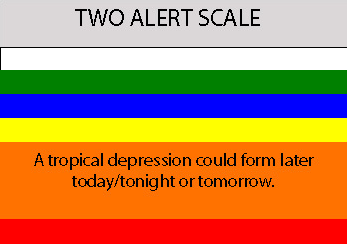
SUBTROPICAL DEPRESSION COULD FORM FROM THIS SYSTEM ON WEDNESDAY AS
THE SYSTEM MOVES SLOWLY AND ERRATICALLY. AN AIR FORCE RESERVE
HURRICANE HUNTER AIRCRAFT IS SCHEDULED TO INVESTIGATE THE SYSTEM
WEDNESDAY AFTERNOON...IF NECESSARY.
ELSEWHERE...TROPICAL CYCLONE FORMATION IS NOT EXPECTED DURING THE
NEXT 48 HOURS.
$$
FORECASTER BEVEN
ABNT20 KNHC 050336
TWOAT
TROPICAL WEATHER OUTLOOK
NWS TPC/NATIONAL HURRICANE CENTER MIAMI FL
1030 PM EDT TUE SEP 4 2007
FOR THE NORTH ATLANTIC...CARIBBEAN SEA AND THE GULF OF MEXICO...
THE NATIONAL HURRICANE CENTER IS ISSUING ADVISORIES ON RECENTLY
DOWNGRADED TROPICAL STORM FELIX...LOCATED INLAND OVER SOUTHEASTERN
HONDURAS.
A NON-TROPICAL AREA OF LOW PRESSURE IS LOCATED ABOUT MIDWAY BETWEEN
BERMUDA AND THE NORTHEAST FLORIDA COAST. WHILE THE UPPER-LEVEL
WINDS ARE CURRENTLY ONLY MARGINALLY FAVORABLE FOR DEVELOPMENT...THE
ASSOCIATED SHOWER ACTIVITY HAS BECOME MORE CONCENTRATED EAST OF THE
CENTER THIS EVENING. IF CURRENT TRENDS CONTINUE...A TROPICAL OR
SUBTROPICAL DEPRESSION COULD FORM FROM THIS SYSTEM ON WEDNESDAY AS
THE SYSTEM MOVES SLOWLY AND ERRATICALLY. AN AIR FORCE RESERVE
HURRICANE HUNTER AIRCRAFT IS SCHEDULED TO INVESTIGATE THE SYSTEM
WEDNESDAY AFTERNOON...IF NECESSARY.
ELSEWHERE...TROPICAL CYCLONE FORMATION IS NOT EXPECTED DURING THE
NEXT 48 HOURS.
$$
FORECASTER BEVEN
0 likes
-
cheezyWXguy
- Category 5
- Posts: 6282
- Joined: Mon Feb 13, 2006 12:29 am
- Location: Dallas, TX


-
windstorm99

- S2K Supporter
- Posts: 1578
- Age: 48
- Joined: Sat May 26, 2007 8:10 am
- Location: Miami, Florida
- Contact:
Re: 99L,Off U.S.E.Coast: Discussions-10:30 PM TWO at page 31
SUBTROPICAL DEPRESSION COULD FORM FROM THIS SYSTEM ON WEDNESDAY AS
THE SYSTEM MOVES SLOWLY AND ERRATICALLY...
ESE-NE basically anybodys guys were this goes right now.
THE SYSTEM MOVES SLOWLY AND ERRATICALLY...
ESE-NE basically anybodys guys were this goes right now.
0 likes
-
Brent
- S2K Supporter
- Posts: 38729
- Age: 37
- Joined: Sun May 16, 2004 10:30 pm
- Location: Tulsa Oklahoma
- Contact:
Re: Invest 99L,Off U.S.E.Coast: Discussions-10:30 PM TWO
Finally! Pretty much echoes my thoughts...
0 likes
-
Matt-hurricanewatcher
Re: 99L,Off U.S.E.Coast: Discussions-10:30 PM TWO at page 31
The fsu shows it has developed a warm core...I expect as the enviroment changes with the high setting up, that things will become even more favorable.
0 likes
-
Tampa Bay Hurricane

- Category 5
- Posts: 5597
- Age: 38
- Joined: Fri Jul 22, 2005 7:54 pm
- Location: St. Petersburg, FL
Re: 99L,Off U.S.E.Coast: Discussions-10:30 PM TWO at page 31
THIS POST IS NOT OFFICIAL. IT MAY NOT HAVE SOUND REASONING. PLEASE
READ THE NATIONAL HURRICANE CENTER WEBSITE FOR OFFICIAL INFORMATION.
If the ridge is very strong...then anywhere from west palm beach, fl
to the outer banks of north carolina are fair game.
I think this will either do a Hurricane Ophelia or
possibly (less likely but depends on the ridge) a
hurricane Jeanne, then get
pushed out over the atlantic restrengthen to
a category 1-2 and hit NC...but too early to tell...
Again I think a combination of jeanne and ophelia
possible if the ridge is very strong like we have seen
this year Jeanne and then it moves off florida and
NNWard.
What it could do is wreak havoc on the east
coast from melbourne up to north carolina
again too early to tell
but we got a Between-Jeanne-and-Ophelia thing happening
IMO even if it does a Jeanne it would
not go inland much and be pretty strong
nearing the carolinas...
So I think NC/SC gets the worst of gabrielle.
and floridas east coast due to a strong intial
ridge gets some intense winds maybe...
but tooo early tooo tell
Last edited by Tampa Bay Hurricane on Tue Sep 04, 2007 10:44 pm, edited 2 times in total.
0 likes
-
Tampa Bay Hurricane
- Category 5
- Posts: 5597
- Age: 38
- Joined: Fri Jul 22, 2005 7:54 pm
- Location: St. Petersburg, FL
THIS POST IS NOT OFFICIAL. IT MAY NOT HAVE SOUND REASONING. PLEASE
READ THE NATIONAL HURRICANE CENTER WEBSITE FOR OFFICIAL INFORMATION.
the models underestimate the ridge
This is Not going out to sea.
ridge to push it west to not far off daytona beach, fl,
and then the trough
pushes it nw into the carolinas.
will probably reach category 2 at least
over the warm gulf stream waters...
north carolina/south carolina will likely
take gabrielles brunt.
landfall in carolinas at 100 mph cat 2.
possibly stronger.
very very windy all along the east coast
from florida to north carolina.
0 likes
-
windstorm99
- S2K Supporter
- Posts: 1578
- Age: 48
- Joined: Sat May 26, 2007 8:10 am
- Location: Miami, Florida
- Contact:
Re: 99L,Off U.S.E.Coast: Discussions-10:30 PM TWO at page 31
Lasest NGM model has this thing coming close to fort lauderdale.....
http://www.nco.ncep.noaa.gov/pmb/nwprod/analysis/namer/ngm/00/index_pcp_s_loop.shtml
http://www.nco.ncep.noaa.gov/pmb/nwprod/analysis/namer/ngm/00/index_pcp_s_loop.shtml
0 likes
Who is online
Users browsing this forum: No registered users and 10 guests