Wave midway between Africa and Lesser Antilles next in Line

This is the general tropical discussion area. Anyone can take their shot at predicting a storms path.

Moderator: S2k Moderators

Forum rules

The posts in this forum are NOT official forecasts and should not be used as such. They are just the opinion of the poster and may or may not be backed by sound meteorological data. They are NOT endorsed by any professional institution or STORM2K. For official information, please refer to products from the National Hurricane Center and National Weather Service.

Help Support Storm2K
Message
Author
User avatar
Meso
Category 5
Category 5
Posts: 1609
Age: 38
Joined: Mon Aug 09, 2004 12:14 pm
Location: South Africa
Contact:

Wave Currently Around 35W/36W

#1 Postby Meso » Mon Sep 03, 2007 10:54 am

Wow... There are 2 areas that the models are developing.. This area that is currently just off the coast/Coming off.And then the next wave coming off in about 2 or 3 days.

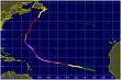
As for this one,it's currently looking decent.3 Models have been developing it,with the GFS now also showing a closed low forming with it.(CMC,UKMET and MM5 are the other models)

Image

Image
1012mb closed low.

Now this may well not do anything,but the fact that 3-4 models are showing something and there is a wave there warrants watching in my opinion
Last edited by Meso on Wed Sep 05, 2007 10:06 am, edited 1 time in total.
0 likes   

User avatar
Meso
Category 5
Category 5
Posts: 1609
Age: 38
Joined: Mon Aug 09, 2004 12:14 pm
Location: South Africa
Contact:

#2 Postby Meso » Mon Sep 03, 2007 12:39 pm

Image
The 12z CMC still showing some development.. Well a closed low with it.
0 likes   

User avatar
Meso
Category 5
Category 5
Posts: 1609
Age: 38
Joined: Mon Aug 09, 2004 12:14 pm
Location: South Africa
Contact:

#3 Postby Meso » Mon Sep 03, 2007 3:41 pm

Image
Not sure if this EURO run is developing the system behind or the one in front due to the amount of hours between forecasts
0 likes   

User avatar
Meso
Category 5
Category 5
Posts: 1609
Age: 38
Joined: Mon Aug 09, 2004 12:14 pm
Location: South Africa
Contact:

#4 Postby Meso » Mon Sep 03, 2007 5:03 pm

Image

The 18z Shows it as a closed low near the Caribbean
0 likes   

User avatar
HURAKAN
Professional-Met
Professional-Met
Posts: 46086
Age: 38
Joined: Thu May 20, 2004 4:34 pm
Location: Key West, FL
Contact:

#5 Postby HURAKAN » Mon Sep 03, 2007 7:30 pm

TROPICAL WEATHER DISCUSSION
NWS TPC/NATIONAL HURRICANE CENTER MIAMI FL
805 PM EDT MON SEP 03 2007

LARGE TROPICAL WAVE IS ALONG 27W S OF 22N MOVING W 15 KT. THIS
WAVE IS EMBEDDED WITHIN A STRETCHED GYRE COVERING CLOSE TO A 15
DEG E-W AREA. A FEW SURROUNDING SHIP/BUOY OBSERVATIONS AND A
PARTIAL QSCAT PASS SUGGEST THAT THIS CYCLONIC TURNING IS AT THE
SFC. THE LATEST SATELLITE IMAGERY SHOWS ROTATION CONCENTRATED
ALONG THE WAVE AXIS NEAR 14N...THUS A 1011 MB LOW IS ADDED TO
THE 18Z SYNOPTIC MAP TO REFLECT THIS. EVEN THOUGH THE WAVE
STRUCTURE HAS IMPROVED A BIT...SHOWER ACTIVITY REMAINS VERY
LIMITED LIKELY SUPPRESSED BY THE STABLE LOW TO MID LEVEL AIR
SURROUNDING THIS FEATURE.
0 likes   

User avatar
HurricaneMaster_PR
Category 2
Category 2
Posts: 795
Joined: Tue Jul 22, 2003 6:23 pm
Location: San Juan, Puerto Rico

Re: Wave Currently Exiting Africa

#6 Postby HurricaneMaster_PR » Mon Sep 03, 2007 7:35 pm

TAFB in the same page as the 18Z GFS

Image
0 likes   

User avatar
HurricaneMaster_PR
Category 2
Category 2
Posts: 795
Joined: Tue Jul 22, 2003 6:23 pm
Location: San Juan, Puerto Rico

Re: Wave Currently Exiting Africa

#7 Postby HurricaneMaster_PR » Mon Sep 03, 2007 7:47 pm

TPC 8:05 TWD

LARGE TROPICAL WAVE IS ALONG 27W S OF 22N MOVING W 15 KT. THIS
WAVE IS EMBEDDED WITHIN A STRETCHED GYRE COVERING CLOSE TO A 15
DEG E-W AREA. A FEW SURROUNDING SHIP/BUOY OBSERVATIONS AND A
PARTIAL QSCAT PASS SUGGEST THAT THIS CYCLONIC TURNING IS AT THE
SFC. THE LATEST SATELLITE IMAGERY SHOWS ROTATION CONCENTRATED
ALONG THE WAVE AXIS NEAR 14N...THUS A 1011 MB LOW IS ADDED TO
THE 18Z SYNOPTIC MAP TO REFLECT THIS. EVEN THOUGH THE WAVE
STRUCTURE HAS IMPROVED A BIT...SHOWER ACTIVITY REMAINS VERY
LIMITED LIKELY SUPPRESSED BY THE STABLE LOW TO MID LEVEL AIR
SURROUNDING THIS FEATURE.
0 likes   

User avatar
Extremeweatherguy
Category 5
Category 5
Posts: 11095
Joined: Mon Oct 10, 2005 8:13 pm
Location: Florida

#8 Postby Extremeweatherguy » Mon Sep 03, 2007 7:56 pm

If that 18z run verifies, then we could potentially be looking at 3 storms forming over the next week. Going to be an interesting time to watch for sure!
0 likes   

User avatar
Vortex
S2K Supporter
S2K Supporter
Posts: 4644
Age: 53
Joined: Fri Aug 01, 2003 9:34 pm
Location: Hilton Head, SC

Wave midway between Africa and Lesser Antilles next in Line

#9 Postby Vortex » Wed Sep 05, 2007 7:25 am

Since exiting the coast of Africa about 3-4 days ago I've been impressed with the large envelope this wave/low has maintained. While there is limited convection at this time the overall structure is there...This system will continue moving west for the next 3-4 days and be near the northern Leewards Sat night/Sunday. As it continues westard it should slowly organize and convection will likely begin to fire near the developing LLC by late Friday...Several models track this system west towards Pueto Rico late this weekend...

Latest Vis...

http://www.ssd.noaa.gov/goes/east/catl/loop-vis.html
0 likes   

Steve H.
Category 5
Category 5
Posts: 2148
Joined: Sat Oct 19, 2002 9:06 am
Location: Palm Bay, Florida

Re: Wave midway between Africa and Lesser Antilles next in Line

#10 Postby Steve H. » Wed Sep 05, 2007 7:56 am

Agree Vort, I was just looking at that and surprised nobody else mentioned it. It is a very large area of circulation and seems to be starting to fire some limited convection to its southwest. That would be a barnburner if it developed 8-)
0 likes   

User avatar
Roswell_Atup
Tropical Low
Tropical Low
Posts: 21
Joined: Sat Sep 01, 2007 11:57 am

Re: Wave midway between Africa and Lesser Antilles next in Line

#11 Postby Roswell_Atup » Wed Sep 05, 2007 8:07 am

was this the 98L invest or another wave?
0 likes   

User avatar
windstorm99
S2K Supporter
S2K Supporter
Posts: 1578
Age: 47
Joined: Sat May 26, 2007 8:10 am
Location: Miami, Florida
Contact:

Re: Wave midway between Africa and Lesser Antilles next in Line

#12 Postby windstorm99 » Wed Sep 05, 2007 8:20 am

Definately a large circulation with that wave but right now its void of any deep thunderstorm activity.Might that change as it moves futher west we'll see.
0 likes   

User avatar
windstorm99
S2K Supporter
S2K Supporter
Posts: 1578
Age: 47
Joined: Sat May 26, 2007 8:10 am
Location: Miami, Florida
Contact:

Re: Wave midway between Africa and Lesser Antilles next in Line

#13 Postby windstorm99 » Wed Sep 05, 2007 8:57 am

Jeff masters 9/5/07

African development?
The models unanimously forecast a tropical depression will develop near the Cape Verdes Islands off the coast of Africa 2-4 days from now. The models showed a similar degree of unanimity for the development of Hurricane Dean in a similar situation, so the chances of another named storm off the coast of Africa early next week are considerable.
0 likes   

User avatar
Meso
Category 5
Category 5
Posts: 1609
Age: 38
Joined: Mon Aug 09, 2004 12:14 pm
Location: South Africa
Contact:

#14 Postby Meso » Wed Sep 05, 2007 10:07 am

I also created a thread on this wave a few days ago when it emerged : viewtopic.php?f=31&t=97681&p=1619380&sid=9593bd3fc5fe91e4e2195ce3b86e8ca4#p1619380
0 likes   

flwxwatcher
Category 4
Category 4
Posts: 926
Joined: Wed May 16, 2007 3:35 pm
Location: Central Florida

Re: Wave midway between Africa and Lesser Antilles next in Line

#15 Postby flwxwatcher » Wed Sep 05, 2007 10:29 am

Vortex wrote:Since exiting the coast of Africa about 3-4 days ago I've been impressed with the large envelope this wave/low has maintained. While there is limited convection at this time the overall structure is there...This system will continue moving west for the next 3-4 days and be near the northern Leewards Sat night/Sunday. As it continues westard it should slowly organize and convection will likely begin to fire near the developing LLC by late Friday...Several models track this system west towards Pueto Rico late this weekend...

Latest Vis...

http://www.ssd.noaa.gov/goes/east/catl/loop-vis.html


Yes.. this has a rather Large envelope to it, This is something to keep a close eye the coming days IMHO.
0 likes   

User avatar
perk
Category 3
Category 3
Posts: 825
Joined: Mon Aug 09, 2004 9:35 am
Location: Richmond Texas

Re: Wave midway between Africa and Lesser Antilles next in Line

#16 Postby perk » Wed Sep 05, 2007 10:35 am

flwxwatcher wrote:
Vortex wrote:Since exiting the coast of Africa about 3-4 days ago I've been impressed with the large envelope this wave/low has maintained. While there is limited convection at this time the overall structure is there...This system will continue moving west for the next 3-4 days and be near the northern Leewards Sat night/Sunday. As it continues westard it should slowly organize and convection will likely begin to fire near the developing LLC by late Friday...Several models track this system west towards Pueto Rico late this weekend...

Latest Vis...

http://www.ssd.noaa.gov/goes/east/catl/loop-vis.html


Yes.. this has a rather Large envelope to it, This is something to keep a close eye the coming days IMHO.

Accuweather seem to think this system can slowly develop in the coming days.
0 likes   

User avatar
perk
Category 3
Category 3
Posts: 825
Joined: Mon Aug 09, 2004 9:35 am
Location: Richmond Texas

Re: Wave midway between Africa and Lesser Antilles next in Line

#17 Postby perk » Wed Sep 05, 2007 10:41 am

If this does form it will probably be north of 15 degrees, and not follow the dean/felix southern tracks.
0 likes   

Zardoz
Category 1
Category 1
Posts: 309
Joined: Fri Aug 25, 2006 9:48 am
Location: Severe weather-challenged Southern California

Re: Wave Currently Around 35W/36W

#18 Postby Zardoz » Wed Sep 05, 2007 12:41 pm

Correct me if I'm wrong, but this wave looks like it's possibly getting ready to do something:

Image


GOES East Rainbow


Image
0 likes   

User avatar
windstorm99
S2K Supporter
S2K Supporter
Posts: 1578
Age: 47
Joined: Sat May 26, 2007 8:10 am
Location: Miami, Florida
Contact:

Re: Wave Currently Around 35W/36W

#19 Postby windstorm99 » Wed Sep 05, 2007 12:49 pm

Youre right convection has increased....
0 likes   

User avatar
cycloneye
Admin
Admin
Posts: 145867
Age: 69
Joined: Thu Oct 10, 2002 10:54 am
Location: San Juan, Puerto Rico

Re: Wave Currently Around 35W/36W

#20 Postby cycloneye » Wed Sep 05, 2007 1:00 pm

LONG WAVELENGTH TROPICAL WAVE IS ALONG 37W/38W S OF 23N MOVING W
NEAR 20 KT OVER THE PAST 24 HOURS. THIS WAVE HAS CHANGED LITTLE
IN STRUCTURE SINCE MOVING OFF THE AFRICAN COAST WITH ABOUT A 15
DEG LONGITUDE AREA OF LOW-LEVEL CYCLONIC TURNING. THE WEAK LOW
THAT WAS STATIONARY ALONG 40W FOR THE PAST FEW DAYS HAS BEEN
DRAWN E INTO THE WAVE'S ROTATION AND IS CURRENTLY CENTERED ALONG
THE WAVE AXIS NEAR 12N...ANALYZED 1013 MB. WHILE THE SATELLITE
PRESENTATION OF THIS WAVE IS IMPRESSIVELY LARGE AND WELL
DEFINED...DEEP SHOWER ACTIVITY IS VERY LIMITED AND CONFINED TO
THE INTERSECTION OF THE ITCZ.

$$
CANGIALOSI


2 PM discussion.
0 likes   


Return to “Talkin' Tropics”

Who is online

Users browsing this forum: cajungal, Cpv17, Ian2401, Killjoy12, LAF92, riapal, sasha_B, wileytheartist and 40 guests