Invest 99L:Off E Coast-Discussions

Moderator: S2k Moderators

Message
Author
User avatar
Extremeweatherguy
Category 5
Category 5
Posts: 11095
Joined: Mon Oct 10, 2005 8:13 pm
Location: Florida

Re: Invest 99L: Off SE Coast-Discussions-Analysis & Imagery

#1901 Postby Extremeweatherguy » Fri Sep 07, 2007 4:13 pm

x-y-no wrote:
windstorm99 wrote:Guys this might be the wrong thread but what is this?

TROPICAL DISCUSSION - INTERNATIONAL DESKS
NWS HYDROMETEOROLOGICAL PREDICTION CENTER CAMP SPRINGS MD
154 PM EDT FRI SEP 07 2007

THE TROUGH LIES
ALONG THE EAST COAST OF THE USA TO THE BAHAMAS/CENTRAL CUBA...WITH
A CLOSED LOW NEAR 28N 74W. AT 24-48 HRS...A WIND MAXIMA OF 50-75KT
WILL EJECT ACROSS THE GULF OF MEXICO...FORCING THE BASE OF THE
TROUGH TO STRETCH TO THE SOUTHWEST ACROSS THE EASTERN GULF TO THE
CAMPECHE SOUND/NORTHERN YUCATAN. THE CLOSED LOW IS TO THEN MOVE
OVER CENTRAL/SOUTHERN FLORIDA...WHILE ANOTHER FORMS OVER THE
CAMPECHE SOUND/TABASCO MEXICO BY 60-72 HRS. ALTHOUGH CONSIDERABLY
WEAKER THAN ON PREVIOUS RUNS...THE MODELS STILL FORECAST A WARM
CORE CYCLONE TO DEVELOP NORTH OF THE ISLANDS..


Thoughts?


they're not talking about 99L ...

I think they're talking about the low in the Gulf that the NAM forecasts.


The coordinates don't fit that region though. The 28N, 74W position they give is located NE of the bahamas.

update: I just saw the pro mets response to this on the other page, and it seems that this was talking about 99L after all.
Last edited by Extremeweatherguy on Fri Sep 07, 2007 4:16 pm, edited 1 time in total.
0 likes   

RL3AO
Moderator-Pro Met
Moderator-Pro Met
Posts: 16308
Joined: Thu Jun 14, 2007 10:03 pm
Location: NC

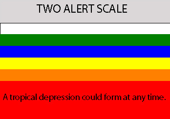
#1902 Postby RL3AO » Fri Sep 07, 2007 4:13 pm

Image
0 likes   

User avatar
Thunder44
Category 5
Category 5
Posts: 5922
Age: 44
Joined: Mon Jun 09, 2003 7:53 pm
Location: New York City

Re: 99L: Off SE Coast-Discussions-5:30 PM TWO Shortly

#1903 Postby Thunder44 » Fri Sep 07, 2007 4:14 pm

Brent wrote:SPECIAL TROPICAL DISTURBANCE STATEMENT
NWS TPC/NATIONAL HURRICANE CENTER MIAMI FL
505 PM EDT FRI SEP 07 2007

THE AIR FORCE RESERVE HURRICANE HUNTER AIRCRAFT INVESTIGATING THE
LOW PRESSURE SYSTEM BETWEEN BERMUDA AND THE SOUTHEAST U.S. COAST
HAS NOT YET IDENTIFIED A WELL-DEFINED CLOSED SURFACE CIRCULATION.
THE AIRCRAFT WILL CONTINUE TO INVESTIGATE THIS SYSTEM...AND IT
COULD BECOME A TROPICAL OR SUBTROPICAL CYCLONE AT ANY TIME AS IT
MOVES WEST-NORTHWESTWARD AT ABOUT 10 MPH. INTERESTS ALONG THE
SOUTHEAST AND MID-ATLANTIC COAST OF THE U.S. SHOULD CLOSELY MONITOR
THE PROGRESS OF THIS SYSTEM...AND TROPICAL STORM WATCHES COULD BE
ISSUED THIS EVENING.


$$
FORECASTER KNABB


I guess those light west winds weren't strong enough for them. :roll:
0 likes   

User avatar
storms in NC
S2K Supporter
S2K Supporter
Posts: 2338
Joined: Thu Jul 28, 2005 2:58 pm
Location: Wallace,NC 40 miles NE of Wilm
Contact:

#1904 Postby storms in NC » Fri Sep 07, 2007 4:15 pm

INTERESTS ALONG THE
SOUTHEAST AND MID-ATLANTIC COAST OF THE U.S. SHOULD CLOSELY MONITOR
THE PROGRESS OF THIS SYSTEM...AND TROPICAL STORM WATCHES COULD BE
ISSUED THIS EVENING.

That is telling me it is going to go more north.JIMO
0 likes   

User avatar
Bane
Category 2
Category 2
Posts: 690
Joined: Wed Sep 17, 2003 3:06 pm
Location: Ogden, NC
Contact:

Re:

#1905 Postby Bane » Fri Sep 07, 2007 4:17 pm

storms in NC wrote:INTERESTS ALONG THE
SOUTHEAST AND MID-ATLANTIC COAST OF THE U.S. SHOULD CLOSELY MONITOR
THE PROGRESS OF THIS SYSTEM...AND TROPICAL STORM WATCHES COULD BE
ISSUED THIS EVENING.

That is telling me it is going to go more north.JIMO


it tells me that if you live from florida to maryland, you need to pay attention to this.
0 likes   

chadtm80

Re: 99L: Off SE Coast-Discussions-5:30 PM TWO Shortly

#1906 Postby chadtm80 » Fri Sep 07, 2007 4:17 pm

Thunder44 wrote:
Brent wrote:SPECIAL TROPICAL DISTURBANCE STATEMENT
NWS TPC/NATIONAL HURRICANE CENTER MIAMI FL
505 PM EDT FRI SEP 07 2007

THE AIR FORCE RESERVE HURRICANE HUNTER AIRCRAFT INVESTIGATING THE
LOW PRESSURE SYSTEM BETWEEN BERMUDA AND THE SOUTHEAST U.S. COAST
HAS NOT YET IDENTIFIED A WELL-DEFINED CLOSED SURFACE CIRCULATION.
THE AIRCRAFT WILL CONTINUE TO INVESTIGATE THIS SYSTEM...AND IT
COULD BECOME A TROPICAL OR SUBTROPICAL CYCLONE AT ANY TIME AS IT
MOVES WEST-NORTHWESTWARD AT ABOUT 10 MPH. INTERESTS ALONG THE
SOUTHEAST AND MID-ATLANTIC COAST OF THE U.S. SHOULD CLOSELY MONITOR
THE PROGRESS OF THIS SYSTEM...AND TROPICAL STORM WATCHES COULD BE
ISSUED THIS EVENING.


$$
FORECASTER KNABB


I guess those light west winds weren't strong enough for them. :roll:


My 4 year old son can stand facing east, pass a little gas, and cause a stronger west wind ;-)

The just said they havent found a WELL DEFINED low.. they will still look, and you will eventualy prob still get your storm.. just relax and be patient
0 likes   

Brent
S2K Supporter
S2K Supporter
Posts: 38088
Age: 36
Joined: Sun May 16, 2004 10:30 pm
Location: Tulsa Oklahoma
Contact:

Re:

#1907 Postby Brent » Fri Sep 07, 2007 4:18 pm

RL3AO wrote:Image


Ooh! Code Red! It's going to be hard to leave this screen this evening.
0 likes   

User avatar
BigA
Professional-Met
Professional-Met
Posts: 1317
Joined: Sun Jul 24, 2005 10:56 pm

Re: 99L:Special Tropical Disturbance Statement at page 95

#1908 Postby BigA » Fri Sep 07, 2007 4:18 pm

I dont understand (and I literally dont understand; I'm not trying to be critical) how they werent able to find a closed circulation if one can clearly see clouds moving in a circular/spiral pattern.
0 likes   

chadtm80

Re: 99L:Special Tropical Disturbance Statement at page 95

#1909 Postby chadtm80 » Fri Sep 07, 2007 4:21 pm

BigA wrote:I dont understand (and I literally dont understand; I'm not trying to be critical) how they werent able to find a closed circulation if one can clearly see clouds moving in a circular/spiral pattern.

They didnt say there wasnt a closed circulation.. they said they havent yet found a WELL DEFINED circulation.. There is a LLC out there for sure though
0 likes   

CrazyC83
Professional-Met
Professional-Met
Posts: 34002
Joined: Tue Mar 07, 2006 11:57 pm
Location: Deep South, for the first time!

Re: 99L:Special Tropical Disturbance Statement at page 95

#1910 Postby CrazyC83 » Fri Sep 07, 2007 4:22 pm

chadtm80 wrote:
BigA wrote:I dont understand (and I literally dont understand; I'm not trying to be critical) how they werent able to find a closed circulation if one can clearly see clouds moving in a circular/spiral pattern.

They didnt say there wasnt a closed circulation.. they said they havent yet found a WELL DEFINED circulation.. There is a LLC out there for sure though


What we probably need is a giant range of numbers close together.
0 likes   

Brent
S2K Supporter
S2K Supporter
Posts: 38088
Age: 36
Joined: Sun May 16, 2004 10:30 pm
Location: Tulsa Oklahoma
Contact:

Re: 99L:Special Tropical Disturbance Statement at page 95

#1911 Postby Brent » Fri Sep 07, 2007 4:22 pm

I have seen numerous "poorly defined" centers get upgraded...
0 likes   

User avatar
cycloneye
Admin
Admin
Posts: 145295
Age: 68
Joined: Thu Oct 10, 2002 10:54 am
Location: San Juan, Puerto Rico

Re: 99L:Special Tropical Disturbance Statement at page 95

#1912 Postby cycloneye » Fri Sep 07, 2007 4:23 pm

Grace :uarrow:
0 likes   

User avatar
GeneratorPower
S2K Supporter
S2K Supporter
Posts: 1648
Age: 45
Joined: Sun Dec 18, 2005 11:48 pm
Location: Huntsville, AL

#1913 Postby GeneratorPower » Fri Sep 07, 2007 4:24 pm

We apparently need Category 2 winds before anything is upgraded this season! Or so it seems.

All joking aside, I wonder if the new acting NHC director may be more conservative, and might have directed the staff to be a little lighter on the ol' trigger finger.
0 likes   

chadtm80

Re: 99L:Special Tropical Disturbance Statement at page 95

#1914 Postby chadtm80 » Fri Sep 07, 2007 4:24 pm

Brent wrote:I have seen numerous "poorly defined" centers get upgraded...

And you will prob eventualy see this one get upgraded as well.. Remember when recon was in the system last time.. Didnt upgrade.. and everyones reaction was just the same as it is now about them not upgrading? What happened then? :-) Just wait for it ;-) Won't have to wait as long this time.. They released a STDS for a reason
0 likes   

Brent
S2K Supporter
S2K Supporter
Posts: 38088
Age: 36
Joined: Sun May 16, 2004 10:30 pm
Location: Tulsa Oklahoma
Contact:

Re: 99L:Special Tropical Disturbance Statement at page 95

#1915 Postby Brent » Fri Sep 07, 2007 4:25 pm

I mean the wording in that STDS makes me think an upgrade is coming tonight because they can't issue TS Watches without an upgrade, so I think we're really just in a wait mode. I hate waiting. :lol:
0 likes   

RL3AO
Moderator-Pro Met
Moderator-Pro Met
Posts: 16308
Joined: Thu Jun 14, 2007 10:03 pm
Location: NC

Re:

#1916 Postby RL3AO » Fri Sep 07, 2007 4:26 pm

GeneratorPower wrote:We apparently need Category 2 winds before anything is upgraded this season! Or so it seems.

All joking aside, I wonder if the new acting NHC director may be more conservative, and might have directed the staff to be a little lighter on the ol' trigger finger.


Remember, that before 2005, they didn't have tens of thousands of people looking at there every decision.
0 likes   

Brent
S2K Supporter
S2K Supporter
Posts: 38088
Age: 36
Joined: Sun May 16, 2004 10:30 pm
Location: Tulsa Oklahoma
Contact:

Re: 99L:Special Tropical Disturbance Statement at page 95

#1917 Postby Brent » Fri Sep 07, 2007 4:28 pm

TROPICAL WEATHER OUTLOOK
NWS TPC/NATIONAL HURRICANE CENTER MIAMI FL
530 PM EDT FRI SEP 7 2007

FOR THE NORTH ATLANTIC...CARIBBEAN SEA AND THE GULF OF MEXICO...

SATELLITE IMAGERY INDICATES THAT SHOWER ACTIVITY ASSOCIATED WITH THE
LOW PRESSURE AREA BETWEEN BERMUDA AND THE SOUTHEASTERN COAST OF THE
UNITED STATES IS GRADUALLY BECOMING BETTER ORGANIZED. HOWEVER...AN
AIR FORCE RESERVE HURRICANE HUNTER AIRCRAFT CURRENTLY INVESTIGATING
THE SYSTEM HAS NOT YET FOUND A WELL-DEFINED CIRCULATION.
UPPER-LEVEL WINDS ARE BECOMING MORE FAVORABLE FOR DEVELOPMENT...AND
A TROPICAL OR SUBTROPICAL CYCLONE COULD FORM AT ANY TIME AS THE
SYSTEM MOVES WEST-NORTHWEST AT ABOUT 10 MPH. INTERESTS ALONG THE
SOUTHEASTERN AND MID-ATLANTIC COAST OF THE U. S. SHOULD CLOSELY
MONITOR THE PROGRESS OF THIS SYSTEM...AND TROPICAL STORM WATCHES
COULD BE ISSUED THIS EVENING.

ELSEWHERE...TROPICAL CYCLONE FORMATION IS NOT EXPECTED DURING THE
NEXT 48 HOURS.

$$

FORECASTER BEVEN
0 likes   

dtrain44
Tropical Storm
Tropical Storm
Posts: 141
Joined: Mon Aug 20, 2007 7:45 am
Location: Norman, OK

Re: Invest 99L:Off E Coast-Discussions-5:30 PM TWO at page 96

#1918 Postby dtrain44 » Fri Sep 07, 2007 4:32 pm

Might be a touch off topic, but is it actually impossible to issue tropical storm watches without an identified TD/TS? I would think that it would make a lot of sense in some circumstances to do that for an invest that is likely to become a cyclone, has not become a cyclone yet, and is likely to hit land before long. That might be confusing, but I'm just wondering if it's against NHC policy to do that....
0 likes   

Brent
S2K Supporter
S2K Supporter
Posts: 38088
Age: 36
Joined: Sun May 16, 2004 10:30 pm
Location: Tulsa Oklahoma
Contact:

Re: Invest 99L:Off E Coast-Discussions-5:30 PM TWO at page 96

#1919 Postby Brent » Fri Sep 07, 2007 4:33 pm

dtrain44 wrote:Might be a touch off topic, but is it actually impossible to issue tropical storm watches without an identified TD/TS? I would think that it would make a lot of sense in some circumstances to do that for an invest that is likely to become a cyclone, has not become a cyclone yet, and is likely to hit land before long. That might be confusing, but I'm just wondering if it's against NHC policy to do that....


I have never seen watches without an official TD at least. Don't think it can happen, which is why I expect an upgrade at 11pm, if not before. It's not possible otherwise.
0 likes   

RL3AO
Moderator-Pro Met
Moderator-Pro Met
Posts: 16308
Joined: Thu Jun 14, 2007 10:03 pm
Location: NC

Re: Invest 99L:Off E Coast-Discussions-5:30 PM TWO at page 96

#1920 Postby RL3AO » Fri Sep 07, 2007 4:33 pm

dtrain44 wrote:Might be a touch off topic, but is it actually impossible to issue tropical storm watches without an identified TD/TS? I would think that it would make a lot of sense in some circumstances to do that for an invest that is likely to become a cyclone, has not become a cyclone yet, and is likely to hit land before long. That might be confusing, but I'm just wondering if it's against NHC policy to do that....


The NHC can't/won't do that.
0 likes   


Return to “2007”

Who is online

Users browsing this forum: No registered users and 2 guests