TD INGRID: Discussions & Images - Last Advisory
Moderator: S2k Moderators

-
wxmann_91

- Category 5

- Posts: 8007
- Age: 34
- Joined: Fri Jul 15, 2005 2:49 pm
- Location: Southern California
- Contact:
Re: Re:
cheezyWXguy wrote:wxmann_91 wrote:There's definitely some SAL to the north, but I think 91L is at a low enough latitude to avoid it... may become a problem for 92L if 92L lingers too long.
Downrange synoptics don't look too good. A large TUTT is expected to the east of Bermuda extending down to the Greater Antilles in about 4-5 days. That will shear any system in the (north)eastern Caribbean to death, most likely. If this system can develop strongly by then, it may be modify the environment somewhat, but otherwise, I don't see another big Caribbean system out of this UNLESS the TUTT manages to stay north enough.
Its a LONG way away from the ECarib. Maybe 4-5 days still, and that TUTT low will likely move out. This change fairly quickly in the tropics.
In terms of long term track, if this goes into the caribbean, it has a much better chance of getting into the GOM than Felix or Dean did. The high just isnt what it used to be, according to what ive been hearing. Though it could follow 92L up over the leewards and be an east coast threat. Only time will tell
It is, so I'm not sure how the TUTT will behave. Nevertheless, I think the wave that just came off Africa this morning has a better chance of developing into a significant system.
I wouldn't say 5 day upper air forecasts are completely useless. The GFS (yes, I know you hate those three letters Derek) has been very persistent in developing the TUTT, and then closing it off into an ULL. If anything, models tend to lift these ULL's out too quickly.
0 likes

Re: Invest 91L East Atlantic-Discussions & Images
Given the current and projected conditions, can anyone speculate (with some kind of backing) the track this storm may take relative to Dean and/or Felix (4-5 days from now)? Are future conditions in the Caribbean favorable for a GOMX-entering storm?
edit: Thanks rock
edit: Thanks rock
Last edited by njweather on Sun Sep 09, 2007 8:24 pm, edited 1 time in total.
0 likes


Re: Invest 91L East Atlantic-Discussions & Images
njweather wrote:Given the current and projected conditions, can anyone speculate (with some kind of backing) the track this storm may take relative to Dean and/or Felix? Are the conditions in the Caribbean favorable for a GOMX-entering storm?
when now or 6 days from now?....all we can do is look at the globals and see if a consenus can be seen. Heat potential will not be a problem...
http://wxmaps.org/pix/hurpot.html#ATL
but other factors can be...such as shear etc etc....so to answer your question it would be speculating at this point.....what we know for sure that it will track west or wnw for a few days. After that, other things come into play.....way to early to be looking at GOM predictions.
0 likes
-
cheezyWXguy

- Category 5
- Posts: 6281
- Joined: Mon Feb 13, 2006 12:29 am
- Location: Dallas, TX
Re: Re:
wxmann_91 wrote:cheezyWXguy wrote:wxmann_91 wrote:There's definitely some SAL to the north, but I think 91L is at a low enough latitude to avoid it... may become a problem for 92L if 92L lingers too long.
Downrange synoptics don't look too good. A large TUTT is expected to the east of Bermuda extending down to the Greater Antilles in about 4-5 days. That will shear any system in the (north)eastern Caribbean to death, most likely. If this system can develop strongly by then, it may be modify the environment somewhat, but otherwise, I don't see another big Caribbean system out of this UNLESS the TUTT manages to stay north enough.
Its a LONG way away from the ECarib. Maybe 4-5 days still, and that TUTT low will likely move out. This change fairly quickly in the tropics.
In terms of long term track, if this goes into the caribbean, it has a much better chance of getting into the GOM than Felix or Dean did. The high just isnt what it used to be, according to what ive been hearing. Though it could follow 92L up over the leewards and be an east coast threat. Only time will tell
It is, so I'm not sure how the TUTT will behave. Nevertheless, I think the wave that just came off Africa this morning has a better chance of developing into a significant system.
I wouldn't say 5 day upper air forecasts are completely useless. The GFS (yes, I know you hate those three letters Derek) has been very persistent in developing the TUTT, and then closing it off into an ULL. If anything, models tend to lift these ULL's out too quickly.
I remember with Dean there was a TUTT low in the ECarrib when it was about the same distance away. It either moved north or died out, but the pattern is very similar, except the high maybe a little weaker
0 likes
-
Derek Ortt
-
wxmann_91
- Category 5
- Posts: 8007
- Age: 34
- Joined: Fri Jul 15, 2005 2:49 pm
- Location: Southern California
- Contact:
Re: Re:
cheezyWXguy wrote:I remember with Dean there was a TUTT low in the ECarrib when it was about the same distance away. It either moved north or died out, but the pattern is very similar, except the high maybe a little weaker
ULL's to the east of a system usually aren't terribly detrimental. And neither are small ULL's to the west and moving in tandem away from the system. In fact both types have been known to enhance outflow and are actually quite characteristic of some of the more significant storms in the past years (Helene, Ivan, Dean, Felix, Mitch all had ULL's to the east ventilating outflow... Dean, Katrina, Rita, Felix I think, Emily had ULL's moving in tandem with the cyclone ot the west).
BUT, large ULL's and TUTT's are a different story. It seems these always take more time to move out and do more to shear cyclones than expected (see Ernesto and Chris). This one looks to be one of those bigger ones.
I guess we'll just have to see what happens. TUTT's/ULL's and their interactions with TC's are always a tricky business.
Derek Ortt wrote:and that model from NCEP was perisstent about this turning to the north now due to a weakness
there is a reason why I do not consider that model from NCEP
Well, the UKMET and NOGAPS are showing a developing TUTT too.
Not just GFS.
0 likes
-
cheezyWXguy
- Category 5
- Posts: 6281
- Joined: Mon Feb 13, 2006 12:29 am
- Location: Dallas, TX
Re: Re:
wxmann_91 wrote:cheezyWXguy wrote:I remember with Dean there was a TUTT low in the ECarrib when it was about the same distance away. It either moved north or died out, but the pattern is very similar, except the high maybe a little weaker
ULL's to the east of a system usually aren't terribly detrimental. And neither are small ULL's to the west and moving in tandem away from the system. In fact both types have been known to enhance outflow and are actually quite characteristic of some of the more significant storms in the past years (Helene, Ivan, Dean, Felix, Mitch all had ULL's to the east ventilating outflow... Dean, Katrina, Rita, Felix I think, Emily had ULL's moving in tandem with the cyclone ot the west).
BUT, large ULL's and TUTT's are a different story. It seems these always take more time to move out and do more to shear cyclones than expected (see Ernesto and Chris). This one looks to be one of those bigger ones.
I guess we'll just have to see what happens. TUTT's/ULL's and their interactions with TC's are always a tricky business.
I was talking about when Dean (maybe it was Felix but im pretty sure it was Dean) was in the CATL, there was a TUTT low over the ECarib, and it was gone long before Dean got there. Im sure it was pretty strong, and shear was bad over there.
0 likes
-
Derek Ortt
and those same models are slowing down this system for what seems to be no good reason
Not having a lage TC is going to render the upper air forecast fairly useless, since the TC will affect the upper air pattern. Besides, the 5 day upper wind forecasts over the ocean almost NEVER verifies... not sure why you are so hung up on this TUTT when there are likely problems with the forecast
Not having a lage TC is going to render the upper air forecast fairly useless, since the TC will affect the upper air pattern. Besides, the 5 day upper wind forecasts over the ocean almost NEVER verifies... not sure why you are so hung up on this TUTT when there are likely problems with the forecast
0 likes
-
miamicanes177
- Category 5
- Posts: 1131
- Joined: Tue Aug 01, 2006 10:53 pm
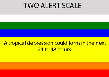
Re: Invest 91L East Atlantic-Discussions=10:30 PM TWO Shortly
000
ABNT20 KNHC 100227
TWOAT
TROPICAL WEATHER OUTLOOK
NWS TPC/NATIONAL HURRICANE CENTER MIAMI FL
1030 PM EDT SUN SEP 9 2007
A BROAD AREA OF LOW PRESSURE...ASSOCIATED WITH A TROPICAL WAVE...IS
LOCATED ABOUT 875 MILES WEST-SOUTHWEST OF THE CAPE VERDE ISLANDS
AND IS PRODUCING A LARGE AREA OF CLOUDINESS AND THUNDERSTORMS. THIS
SYSTEM HAS BECOME A LITTLE BETTER ORGANIZED THIS EVENING...AND IT
HAS THE POTENTIAL TO DEVELOP INTO A TROPICAL DEPRESSION DURING THE
NEXT COUPLE OF DAYS AS IT MOVES WESTWARD TO WEST-NORTHWESTWARD
AROUND 15 MPH.
FORECASTER BLAKE/PASCH
Last edited by miamicanes177 on Sun Sep 09, 2007 9:32 pm, edited 1 time in total.
0 likes
-
GeneratorPower

- S2K Supporter

- Posts: 1648
- Age: 46
- Joined: Sun Dec 18, 2005 11:48 pm
- Location: Huntsville, AL
000
ABNT20 KNHC 091530
TWOAT
TROPICAL WEATHER OUTLOOK
NWS TPC/NATIONAL HURRICANE CENTER MIAMI FL1
1130 AM EDT SUN SEP 9 2007
FOR THE NORTH ATLANTIC...CARIBBEAN SEA AND THE GULF OF MEXICO...
THE NATIONAL HURRICANE CENTER IS ISSUING ADVISORIES ON TROPICAL
STORM GABRIELLE...CENTERED NEAR THE COAST OF NORTH CAROLINA BETWEEN
CAPE LOOKOUT AND OCRACOKE INLET.
1. A BROAD AREA OF LOW PRESSURE...ASSOCIATED WITH A TROPICAL WAVE...IS
LOCATED ABOUT 700 MILES WEST-SOUTHWEST OF THE CAPE VERDE ISLANDS
AND IS PRODUCING A LARGE AREA OF CLOUDINESS AND THUNDERSTORMS.
CONDITIONS APPEAR CONDUCIVE FOR GRADUAL DEVELOPMENT OF THIS SYSTEM
DURING THE NEXT COUPLE OF DAYS AS IT MOVES WESTWARD AT ABOUT 15
MPH.
2. SHOWERS AND THUNDERSTORMS A FEW HUNDRED MILES EAST OF THE LEEWARD
ISLANDS ARE ASSOCIATED WITH A TROPICAL WAVE. SLOW DEVELOPMENT OF
THIS SYSTEM IS POSSIBLE AS IT MOVES WESTWARD AT ABOUT 15 MPH...AND
IT COULD BRING SOME SHOWER ACTIVITY TO THE NORTHERN LEEWARD ISLANDS
DURING THE NEXT DAY OR TWO.
3. DISORGANIZED SHOWERS AND THUNDERSTORMS OVER THE SOUTHERN GULF OF
MEXICO ARE ASSOCIATED WITH A WEAK SURFACE TROUGH AND AN UPPER-LEVEL
LOW. CONDITIONS ARE NOT FAVORABLE FOR DEVELOPMENT OF THIS SYSTEM.
ELSEWHERE...TROPICAL CYCLONE FORMATION IS NOT EXPECTED DURING THE
NEXT 48 HOURS.
$$
FORECASTER KNABB
Last edited by GeneratorPower on Sun Sep 09, 2007 9:32 pm, edited 1 time in total.
0 likes


http://www.ssd.noaa.gov/goes/east/catl/rb-l.jpg
Oooh look at the pretty colors.
As you can see 91L is refiring convection rather nicely.
any one think that the SAL to the north might destroy this wave.
Oooh look at the pretty colors.
As you can see 91L is refiring convection rather nicely.
any one think that the SAL to the north might destroy this wave.
0 likes
-
windstorm99

- S2K Supporter
- Posts: 1578
- Age: 48
- Joined: Sat May 26, 2007 8:10 am
- Location: Miami, Florida
- Contact:
Re: Invest 91L East Atlantic-Discussions=10:30 PM TWO Shortly
1030PM NHC OUTLOOK
A BROAD AREA OF LOW PRESSURE...ASSOCIATED WITH A TROPICAL WAVE...IS
LOCATED ABOUT 875 MILES WEST-SOUTHWEST OF THE CAPE VERDE ISLANDS
AND IS PRODUCING A LARGE AREA OF CLOUDINESS AND THUNDERSTORMS. THIS
SYSTEM HAS BECOME A LITTLE BETTER ORGANIZED THIS EVENING...AND IT
HAS THE POTENTIAL TO DEVELOP INTO A TROPICAL DEPRESSION DURING THE
NEXT COUPLE OF DAYS AS IT MOVES WESTWARD TO WEST-NORTHWESTWARD
AROUND 15 MPH.
0 likes

-
wxmann_91
- Category 5
- Posts: 8007
- Age: 34
- Joined: Fri Jul 15, 2005 2:49 pm
- Location: Southern California
- Contact:
and those same models are slowing down this system for what seems to be no good reason
Not having a lage TC is going to render the upper air forecast fairly useless, since the TC will affect the upper air pattern. Besides, the 5 day upper wind forecasts over the ocean almost NEVER verifies... not sure why you are so hung up on this TUTT when there are likely problems with the forecast
I'm mentioning the TUTT b/c I do think it could have an effect. IF this system is small and compact I do think that the system could suffer. However IF it is far south enough and an UL anticyclone can assert itself, the TUTT's influenced would be dramatically decreased.
I'm not really talking about specifics here, but simply the fact that a TUTT could be there. It's just something to watch. The models were progging a near perfect upper air environment for both Dean and Felix. I'll eat crow if I'm wrong WRT the TUTT.
0 likes
-
terrapintransit

- Category 1

- Posts: 275
- Age: 51
- Joined: Tue Sep 04, 2007 8:08 pm
- Location: Williamsport, Pa
Re: Invest 91L East Atlantic-Discussions=10:30 PM TWO Shortly
Keep up the great work!!!!!!! I love watching all of this unfold
0 likes

-
Gustywind

- Category 5
- Posts: 12334
- Joined: Mon Sep 03, 2007 7:29 am
- Location: Baie-Mahault, GUADELOUPE
Maybe we should forget the shear for 91L, seems that no shear or very very light will occur during the future trip of this system ....very very good conditions or my eyes are deceiving me!!!!!
24hshear:
http://www.intellicast.com/Storm/Hurric ... nds24.aspx
48h shear:
http://www.intellicast.com/Storm/Hurric ... nds24.aspx
72h shear:
http://www.intellicast.com/Storm/Hurric ... nds72.aspx

24hshear:
http://www.intellicast.com/Storm/Hurric ... nds24.aspx
48h shear:
http://www.intellicast.com/Storm/Hurric ... nds24.aspx
72h shear:
http://www.intellicast.com/Storm/Hurric ... nds72.aspx
0 likes
-
AtlanticWind

- S2K Supporter
- Posts: 1898
- Age: 67
- Joined: Sun Aug 08, 2004 9:57 pm
- Location: Plantation,Fla
Re: 91L -Discussions=10:30 PM TWO at page 6,Better Organized
This continues to look like it could be a classic large September Cape Verde Hurricane.
0 likes
Who is online
Users browsing this forum: No registered users and 74 guests