Wave in Eastern Atlantic
Moderator: S2k Moderators
Forum rules

The posts in this forum are NOT official forecasts and should not be used as such. They are just the opinion of the poster and may or may not be backed by sound meteorological data. They are NOT endorsed by any professional institution or STORM2K. For official information, please refer to products from the National Hurricane Center and National Weather Service.

-
Gustywind

- Category 5

- Posts: 12334
- Joined: Mon Sep 03, 2007 7:29 am
- Location: Baie-Mahault, GUADELOUPE
Re: Next Wave Emerges off Africa
http://www.nrlmry.navy.mil/sat-bin/disp ... C_SCALE=15
4 systems on Africa the first coming of right now seems decent , the second as a squall line with C shape looking good with a cluster forming on it right side, the third behing is larger an souther than the previous, and to the right and farther east the last system seems to have mutilayered pacthes of convection with small tstorms......All in all things getting interresting for tommorow and the next couples of days as we're entering the peak of the season
4 systems on Africa the first coming of right now seems decent , the second as a squall line with C shape looking good with a cluster forming on it right side, the third behing is larger an souther than the previous, and to the right and farther east the last system seems to have mutilayered pacthes of convection with small tstorms......All in all things getting interresting for tommorow and the next couples of days as we're entering the peak of the season
0 likes


-
Fego

- S2K Supporter

- Posts: 767
- Age: 65
- Joined: Sun Apr 18, 2004 7:58 pm
- Location: San Juan, Puerto Rico
- Contact:
Re: Next Wave Emerges off Africa
New kid on the block

NCH 8:00a.m. TWD'
"TROPICAL WAVE IS INTRODUCED ON THE 06Z ANALYSIS ABOUT 120 NM E
OF THE CAPE VERDE ISLANDS ALONG 20W/21W S OF 19N ESTIMATED TO BE
MOVING W 10-15 KT. SEVERAL DATA SOURCES SUPPORT THE EXISTENCE
AND LOCATION OF THIS WAVE. THE CLEAREST IS THE CURRENT
PRESENTATION ON VISIBLE IMAGES. WELL DEFINED LOW-LEVEL TURNING
AND A CLASSIC INVERTED V-SHAPE TO THE LOW CLOUD FIELD IS
PRESENT. THIS SATELLITE SIGNATURE MESHES UP WELL WITH THE SFC
OBSERVATIONS IN THE AREA. MET-9 SAT HOVMOLLER DIAGRAMS AND THE
UW-CIMSS TPW ANIMATION SHOW GOOD WWD CONTINUITY AND A
SIGNIFICANT ASSOCIATED BULGE OF MOISTURE. CONVECTION IS FAIRLY
MINIMAL AND CONFINED TO AN AREA W OF THE AXIS FROM 14N-16N
BETWEEN 22W-25W WHERE SPEED CONVERGENCE IS NOTED ON A 07Z QSCAT
PASS."
0 likes

-
Matt-hurricanewatcher
Re: Next Wave Emerges off Africa
Is this the system at 10/30? If it is its looking very good tonight.
0 likes
-
Gustywind
- Category 5
- Posts: 12334
- Joined: Mon Sep 03, 2007 7:29 am
- Location: Baie-Mahault, GUADELOUPE
Wave introduced yesterday continuing to travel west.....
000
AXNT20 KNHC 111053
TWDAT
TROPICAL WEATHER DISCUSSION
NWS TPC/NATIONAL HURRICANE CENTER MIAMI FL
805 AM EDT TUE SEP 11 2007
TROPICAL WEATHER DISCUSSION FOR NORTH AMERICA...CENTRAL
AMERICA...THE GULF OF MEXICO...THE CARIBBEAN SEA...NORTHERN
SECTIONS OF SOUTH AMERICA...AND THE ATLANTIC OCEAN TO THE
AFRICAN COAST FROM THE EQUATOR TO 32N. THE FOLLOWING INFORMATION
IS BASED ON SATELLITE IMAGERY...METEOROLOGICAL ANALYSIS...
WEATHER OBSERVATIONS...AND RADAR.
BASED ON 0600 UTC SURFACE ANALYSIS AND SATELLITE IMAGERY THROUGH
1045 UTC.
TROPICAL WAVE WAS ADJUSTED A FEW DEGREES TO THE WEST PASSED THE
CAPE VERDE ISLANDS ALONG 27W/28W S OF 22N MOVING W 15 KT. THIS
ADJUSTMENT WAS BASED PRIMARILY ON THE DISTINCT LOW LEVEL
TURNING SEEN ON THE FIRST FEW VIS IMAGES OF THE DAY AND THE
CIMSS TPW ANIMATION. THESE DATA SOURCES SHOW ROTATION MOST
CONCENTRATED ACROSS THE NRN EXTENSION AND IT APPEARS AS IF A
WEAK LOW IS TRYING TO FORM ALONG THE AXIS NEAR 17N...ALTHOUGH IT
MAY NOT BE AT THE SFC. WHILE THE WAVE STRUCTURE IS WELL
DEFINED...CONVECTION REMAINS CONFINED WELL TO THE SW OF THE AXIS
WITHIN THE INTERSECTION OF THE ITCZ FROM 9N-13N BETWEEN 29W-35W. 
000
AXNT20 KNHC 111053
TWDAT
TROPICAL WEATHER DISCUSSION
NWS TPC/NATIONAL HURRICANE CENTER MIAMI FL
805 AM EDT TUE SEP 11 2007
TROPICAL WEATHER DISCUSSION FOR NORTH AMERICA...CENTRAL
AMERICA...THE GULF OF MEXICO...THE CARIBBEAN SEA...NORTHERN
SECTIONS OF SOUTH AMERICA...AND THE ATLANTIC OCEAN TO THE
AFRICAN COAST FROM THE EQUATOR TO 32N. THE FOLLOWING INFORMATION
IS BASED ON SATELLITE IMAGERY...METEOROLOGICAL ANALYSIS...
WEATHER OBSERVATIONS...AND RADAR.
BASED ON 0600 UTC SURFACE ANALYSIS AND SATELLITE IMAGERY THROUGH
1045 UTC.
TROPICAL WAVE WAS ADJUSTED A FEW DEGREES TO THE WEST PASSED THE
CAPE VERDE ISLANDS ALONG 27W/28W S OF 22N MOVING W 15 KT. THIS
ADJUSTMENT WAS BASED PRIMARILY ON THE DISTINCT LOW LEVEL
TURNING SEEN ON THE FIRST FEW VIS IMAGES OF THE DAY AND THE
CIMSS TPW ANIMATION. THESE DATA SOURCES SHOW ROTATION MOST
CONCENTRATED ACROSS THE NRN EXTENSION AND IT APPEARS AS IF A
WEAK LOW IS TRYING TO FORM ALONG THE AXIS NEAR 17N...ALTHOUGH IT
MAY NOT BE AT THE SFC. WHILE THE WAVE STRUCTURE IS WELL
DEFINED...CONVECTION REMAINS CONFINED WELL TO THE SW OF THE AXIS
WITHIN THE INTERSECTION OF THE ITCZ FROM 9N-13N BETWEEN 29W-35W.
0 likes

-
HURAKAN

- Professional-Met

- Posts: 46086
- Age: 38
- Joined: Thu May 20, 2004 4:34 pm
- Location: Key West, FL
- Contact:
Loop: http://www.ssd.noaa.gov/goes/flt/t2/sloop-avn.html
There seems to be some rotation in the clouds associated with this sytem. This loop is from 91L but you can see this area of interest to the right. Looks interesting.
There seems to be some rotation in the clouds associated with this sytem. This loop is from 91L but you can see this area of interest to the right. Looks interesting.
0 likes
Re: Next Wave Emerges off Africa
That second wave is definitely pulling surface clouds into it. It has such a distorted shape that it is pulling its main surface banding from the WNW - in the direction of 91L. This could explain why 91L is having problems.
0 likes
-
Zardoz
- Category 1

- Posts: 309
- Joined: Fri Aug 25, 2006 9:48 am
- Location: Severe weather-challenged Southern California
Re: Next Wave Emerges off Africa
Sanibel wrote:That second wave is definitely pulling surface clouds into it. It has such a distorted shape that it is pulling its main surface banding from the WNW - in the direction of 91L. This could explain why 91L is having problems.
Are my eyes deceiving me, or is there now virtually as much circulation showing at 32W as there is under 91L at 43W?
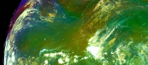
Central Atlantic Rainbow
0 likes

Re: Next Wave Emerges off Africa
Zardoz wrote:Are my eyes deceiving me, or is there now virtually as much circulation showing at 32W as there is under 91L at 43W?
Looking at the visible, I dont really see a circulation at 32W, but there could be an early circulation there.
0 likes
Who is online
Users browsing this forum: Hammy and 100 guests