

While I admit it may be very weak, to say absolutely it is not a tropical threat would be false. It may be one of those things that just gets a special statement or some thing of that nature. I am not trying to play it up too much, but I have lived a long enough time to see these situations happen quite a few times. Just because it does not have a chance to become something major, does not mean it is not an interesting weather phenomena. Sometimes these are more fun to look at then the "for sure" systems. I can plainly see rotation on brownsville radar even if it is at the mid levels.
Hector
Post-90L: Discussions & Imagery: T1.0/1.0
Moderator: S2k Moderators
Forum rules

The posts in this forum are NOT official forecasts and should not be used as such. They are just the opinion of the poster and may or may not be backed by sound meteorological data. They are NOT endorsed by any professional institution or STORM2K. For official information, please refer to products from the National Hurricane Center and National Weather Service.
-
Ed Mahmoud
Re: Post-90L: Discussions, & Imagery
wxman57 wrote:It's clear from the analysis I posted that the lowest pressure measured anywhere around the trof is 1013.5mb, though the pressure near the trof axis could be a millibar lower. Perhaps a very, very weak low near 26N/96W, but it's not very significant. This appears to be a heavy rain threat not a TC development threat.
How do rate the odds of JB's 'sustained tropical storm force winds, at least in a squall, somewhere on the Texas coast' forecast.
Of course, even a garden variety t-storm can blow that hard for a few minutes, but he was implying from a TC.
0 likes
-
jasons2k

- Storm2k Executive

- Posts: 8290
- Age: 52
- Joined: Wed Jul 06, 2005 12:32 pm
- Location: The Woodlands, TX
In summary, this is where we're at IMO:
Pros for development:
1) There is a broad, weak low present (depending on who you ask)
2) Convection has been persistent
3) Shear is relaxing
4) Most of the models now close-off a low before it arrives on the coast
5) The TWOs are moving up our little in-house scale
6) Yesterday nobody gave this the time of day; today it's being watched
7) JB hyping
Cons for development:
1) Is still very disorganized
2) No actual low pressure center, still an open trough (depending on who you ask)
3) Close proximity to land
4) Still significant outflow boundries, especailly on the eastern side
5) Most pro mets expect nothing more than a rainmaker
IMO the big question that tips the scale one way or the other: does the system stall or move inland before it develops?? Answer: we don't know yet. Maybe so, maybe not....
0 likes

-
Ed Mahmoud
Re: Post-90L: Discussions, & Imagery
This is the databuoy off Galveston, are the spikes up in both wind and pressure outlfow boundaries passing, or what?
http://ndbc.noaa.gov/plot_wind_pres.php?station=42035&uom=E
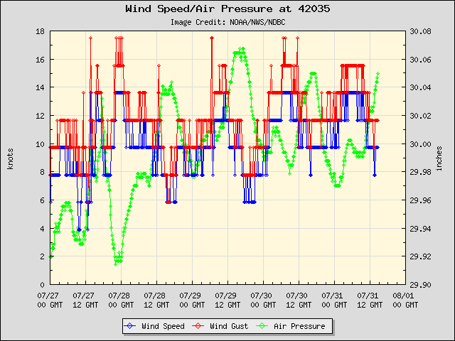
*edited by sg to add the URL tags
http://ndbc.noaa.gov/plot_wind_pres.php?station=42035&uom=E
*edited by sg to add the URL tags
0 likes
Re:
jschlitz wrote:In summary, this is where we're at IMO:
Pros for development:
1) There is a broad, weak low present (depending on who you ask)
2) Convection has been persistent
3) Shear is relaxing
4) Most of the models now close-off a low before it arrives on the coast
5) The TWOs are moving up our little in-house scale
6) Yesterday nobody gave this the time of day; today it's being watched
7) JB hyping
Cons for development:
1) Is still very disorganized
2) No actual low pressure center, still an open trough (depending on who you ask)
3) Close proximity to land
4) Still significant outflow boundries, especailly on the eastern side
5) Most pro mets expect nothing more than a rainmaker
IMO the big question that tips the scale one way or the other: does the system stall or move inland before it develops?? Answer: we don't know yet. Maybe so, maybe not....
I'm beginning to wonder if "JB hyping" shouldn't be listed as a "con"
0 likes
-
Stormcenter
- S2K Supporter

- Posts: 6689
- Joined: Wed Sep 03, 2003 11:27 am
- Location: Houston, TX
-
Ed Mahmoud
Re: Post-90L: Discussions, & Imagery
JB is 3/4 on 'rabbit out of a hat' (TC not directly from tropical waves) storms, Barry, Erin and Gabrielle, and the one he missed was 95L, which was at least labelled an invest.
So his fielding average is .750
So his fielding average is .750
0 likes
Re: Post-90L: Discussions, & Imagery
JB hyping can be expected but this time, I see where his 'hype' is coming from.
0 likes
-
Stratosphere747
- Category 5

- Posts: 3772
- Joined: Thu Sep 11, 2003 8:34 pm
- Location: Surfside Beach/Freeport Tx
- Contact:
Re:
Stormcenter wrote:Here is the way I look at it. I've seen systems (see Gabby) hyped this season by non-pro and pro Mets that didn't pan out. Maybe just maybe this will be just the opposit and is turn into something even though a majority seem to want to just ignore it or give it no chance.
I don't think anyone is ignoring it or giving it no chance Storm. It's clearly about finding a definitive closed low that is strong enough to imply a developing TD/TS. We have not made it to that point yet. I will give you that it's far more interesting that it ever has been.
0 likes
Re: Post-90L: Discussions, & Imagery
Ed Mahmoud wrote:JB is 3/4 on 'rabbit out of a hat' (TC not directly from tropical waves) storms, Barry, Erin and Gabrielle, and the one he missed was 95L, which was at least labelled an invest.
So his fielding average is .750
Don't get me wrong...I really like his work and enjoy his analyses. Heck, I must...I'm paying to see them.
But if he has a 'fault', it's that he thrives more on being the first to discover something (rabbits) than he does on getting the final strength and landfall right. It's not as important, in my opinion, to determine where the next TC will form as it is knowing what it will eventually become and target.
My uneducated guess is that this one will become a minimal TC by tomorrow, and will slide NE up the TX coast as the 'front' stalls and washes out. My yard is a swamp; we don't need this.
0 likes
-
Stormcenter
- S2K Supporter
- Posts: 6689
- Joined: Wed Sep 03, 2003 11:27 am
- Location: Houston, TX
Re: Post-90L: Discussions, & Imagery
Here is nice loop of the area.
http://www.meteo.psu.edu/~gadomski/SAT_GULF/anim8vis.html
*edited by sg to add the URL tags
http://www.meteo.psu.edu/~gadomski/SAT_GULF/anim8vis.html
*edited by sg to add the URL tags
0 likes
-
Starburst

- S2K Supporter
- Posts: 484
- Joined: Sun Aug 28, 2005 11:03 pm
- Location: Beeville, TX
- Contact:
Re: Post-90L: Discussions, & Imagery
Our wind here is a steady 12 mph from the NE and I am loving it. This is the hardest breeze we have had all summer 
0 likes
-
srainhoutx

- S2K Supporter
- Posts: 6919
- Age: 68
- Joined: Sun Jan 14, 2007 11:34 am
- Location: Haywood County, NC
- Contact:
Re: Post-90L: Discussions, & Imagery
Snipet of afternoon TWD from NHC/TPC...
AXNT20 KNHC 111746
TWDAT
TROPICAL WEATHER DISCUSSION
NWS TPC/NATIONAL HURRICANE CENTER MIAMI FL
205 PM EDT TUE SEP 11 2007
TROPICAL WEATHER DISCUSSION FOR NORTH AMERICA...CENTRAL
AMERICA...THE GULF OF MEXICO...THE CARIBBEAN SEA...NORTHERN
SECTIONS OF SOUTH AMERICA...AND THE ATLANTIC OCEAN TO THE
AFRICAN COAST FROM THE EQUATOR TO 32N. THE FOLLOWING INFORMATION
IS BASED ON SATELLITE IMAGERY...METEOROLOGICAL ANALYSIS...
WEATHER OBSERVATIONS...AND RADAR.
BASED ON 1200 UTC SURFACE ANALYSIS AND SATELLITE IMAGERY THROUGH
1715 UTC.
DISCUSSION...
THE GULF OF MEXICO...THE MAIN FEATURE IN THE GULF IS A 1011 MB LOW PRES SYSTEM
CENTERED NEAR 26N95W. A TROUGH EXTENDS MAINLY SOUTH FROM THE LOW
TO THE BAY OF CAMPECHE...WHERE THERE WAS A CLUSTER OF SCATTERED
MODERATE TO STRONG CONVECTION THIS MORNING. ANOTHER SFC TROUGH
EXTENDS NE FROM THE LOW TO SE LOUISIANA. THIS LOW AND TROUGH
SHOW UP NICELY IN THE SHIP...BUOY AND EARLIER QSCAT DATA. CU
LINES ALSO DEFINE THE POSITION OF THE LOW OVER THE NW CORNER OF
THE GULF. UPPER-LEVEL WINDS HAVE BECOME A LITTLE MORE FAVORABLE
FOR DEVELOPMENT. HOWEVER...DEVELOPMENT...IF ANY...SHOULD BE SLOW
TO OCCUR DUE TO PROXIMITY TO LAND. SCATTERED SHOWERS AND TSTMS
ARE N OF 24N WEST OF 90W RELATED TO THIS LOW. SIMILAR CONVECTION
IS OBSERVED ALONG THE N GULF WATERS...INCLUDING THE COAST OF
LOUISIANA AND THE FLORIDA PANHANDLE. AN UPPER LOW OVER THE NE
GULF CENTERED NEAR 27N84W IS ENHANCING THIS ACTIVITY. A WEAK
COLD FRONT IS APPROACHING THE COAST OF TEXAS. THE FRONT WILL
STALL BRIEFLY OVER THE NW GULF WATERS WED THEN DRIFT W THU AND
FRI AS A RIDGE BUILDS W OVER NORTHERN GULF.
0 likes
-
Stratosphere747
- Category 5
- Posts: 3772
- Joined: Thu Sep 11, 2003 8:34 pm
- Location: Surfside Beach/Freeport Tx
- Contact:
Who knows, it may become an invest again. Looks also like it would retain the original invest #.
http://www.ssd.noaa.gov/PS/TROP/positions.html
11/1745 UTC 26.0N 95.7W T1.0/1.0 90L -- Atlantic Ocean
http://www.ssd.noaa.gov/PS/TROP/positions.html
11/1745 UTC 26.0N 95.7W T1.0/1.0 90L -- Atlantic Ocean
0 likes
-
Stratosphere747
- Category 5
- Posts: 3772
- Joined: Thu Sep 11, 2003 8:34 pm
- Location: Surfside Beach/Freeport Tx
- Contact:
Re: Post-90L: Discussions, & Imagery
AREA FORECAST DISCUSSION http://www.weather.gov/view/prodsByStat ... discussion
NATIONAL WEATHER SERVICE BROWNSVILLE TX
152 PM CDT TUE SEP 11 2007
.DISCUSSION...A WEAK SURFACE LOW REMAINS JUST OFFSHORE OVER THE
WESTERN GULF. THE CIRCULATION WAS NOTICEABLE ON RADAR IN THE SHOWER
ACTIVITY OFFSHORE EARLIER BUT IS HARDER TO DETECT NOW. THE GFS
BRINGS THE LOW ONSHORE IN THE BRO CWA WEDNESDAY AFTERNOON AND THEN
DRIFTS IT SLOWLY NORTHWARD ON THURSDAY. IT THEN RE-FORMS THE LOW
PRESSURE BACK TO THE SOUTH AND KEEPS SURFACE LOW PRESSURE IN OUR
REGION THROUGH SATURDAY. THE NAM BRINGS THE LOW TO THE COAST NEAR
BRO AND ALSO DRIFTS IT SLOWLY TO THE NORTH ON THURSDAY BEFORE
SHOWING LOWER PRESSURE TO THE WEST ON SATURDAY. HOWEVER...THE NAM
CONTINUES TO BE MORE AGGRESSIVE IN DEVELOPING THE LOW AS IT NEARS
THE COAST AND EVEN DEVELOPS TROPICAL-STORM FORCE WINDS ON WEDNESDAY.
THIS SOLUTION SEEMS TO BE FAR TOO STRONG AND WILL CONTINUE TO LEAN
TOWARD THE GFS IN THE DEVELOPMENT OF THIS SYSTEM IN AGREEMENT WITH
THE LATEST MODEL DIAGNOSTIC DISCUSSION FROM HPC. THIS IS ALSO IN
AGREEMENT WITH THE LATEST TROPICAL WEATHER DISCUSSION FROM TPC WHICH
SAYS IN REGARDS TO THIS SYSTEM THAT "DEVELOPMENT...IF ANY...SHOULD
BE SLOW TO OCCUR DUE TO PROXIMITY TO LAND." ANOTHER FEATURE OF NOTE
IS THE WEAK COLD FRONT NOW OVER CENTRAL TEXAS. BOTH THE NAM AND GFS
SEEM TO DISSIPATE THIS FRONT OVER THE BRO CWA AS THE LOW MOVES
ONSHORE AND THUS THE FRONT IS NOT EXPECTED TO HAVE MUCH EFFECT ON
DEEP SOUTH TEXAS.
0 likes

Re: Post-90L: Discussions, & Imagery
A local met mentioned this "system" and stated that it will probably sit out in the western GOM for a while and then get picked up to the N or NE by the secondary front. He mentioned that it may have time to develop into something. Anyone hearing the same thing?
0 likes
-
Stormcenter
- S2K Supporter
- Posts: 6689
- Joined: Wed Sep 03, 2003 11:27 am
- Location: Houston, TX
Re: Post-90L: Discussions, & Imagery
Well to my untrained eyes the low that everyone has been tracking seems more diffused
now and hard to make out. My eyes are starting to focus to the NE of the previously mentioned low. IMO
http://www.ssd.noaa.gov/goes/east/gmex/loop-vis.html
now and hard to make out. My eyes are starting to focus to the NE of the previously mentioned low. IMO
http://www.ssd.noaa.gov/goes/east/gmex/loop-vis.html
0 likes
Re: Post-90L: Discussions, & Imagery
Interesting Stormcenter. I too, with untrained eyes, seem to turn my attention in that direction.
0 likes
-
srainhoutx
- S2K Supporter
- Posts: 6919
- Age: 68
- Joined: Sun Jan 14, 2007 11:34 am
- Location: Haywood County, NC
- Contact:
Who is online
Users browsing this forum: No registered users and 183 guests