TD INGRID: Discussions & Images - Last Advisory

Moderator: S2k Moderators

Message
Author
User avatar
CalmBeforeStorm
Category 2
Category 2
Posts: 600
Age: 71
Joined: Tue Aug 10, 2004 7:55 pm
Location: Stuart, Florida

Re: Invest 91L,East of Windwards: Discussions & Images

#621 Postby CalmBeforeStorm » Tue Sep 11, 2007 3:15 pm

Cyclenall wrote:This is an opinion and not an offical product or forecast.

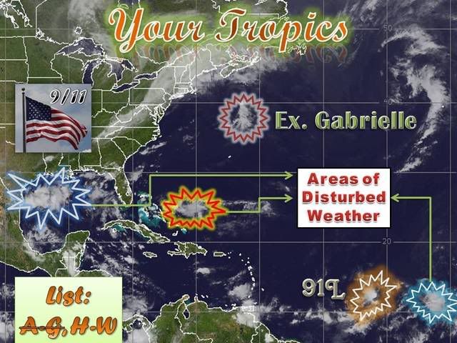
Second % chance of Invest 91L becoming a:

Tropical Depression: 60%
Tropical Storm: 55%
Hurricane: 50%

I think it has gotten some more convection but still a little shear hampering TC formation. I gave it a 50% chance of being a TD by 11:00 pm tonight, yesterday and now I change that to 35% and 50% for tomorrow at 11:00 am.


Considering the improved structure, the time of year and where it's at in the Atlantic I say it's a 90-95% chance this is a depression and given the climatological factors not much less chance that it becomes a tropical storm and eventually a hurricane. This is close to a done deal.
0 likes   

chadtm80

Re: Invest 91L,East of Windwards: Discussions & Images

#622 Postby chadtm80 » Tue Sep 11, 2007 3:16 pm

Image
0 likes   

RL3AO
Moderator-Pro Met
Moderator-Pro Met
Posts: 16308
Joined: Thu Jun 14, 2007 10:03 pm
Location: NC

#623 Postby RL3AO » Tue Sep 11, 2007 3:19 pm

This might be the storm JB has been waiting a long time for...
0 likes   

User avatar
Blown Away
S2K Supporter
S2K Supporter
Posts: 10146
Joined: Wed May 26, 2004 6:17 am

Re: Invest 91L,East of Windwards: Discussions & Images

#624 Postby Blown Away » Tue Sep 11, 2007 3:23 pm

gatorcane wrote:
Matt-hurricanewatcher wrote:If this follows the Gfs/Gfdl or new hurricane models this could be a "fish", but a new ridge may form. So its not a clear cut forecast. On the other hand if the models have any clue at all on how to forecast, another system maybe that system to the east of this, could go onto become Ingrid. We will see.


Based on the last run of the GFS, it takes this WNW to NW and then it ultimately builds a ridge over the EC and brings this system into the FL peninsula.

But that was just one run and way out mind you so don't take this too seriously. We need consistency.


Can you provide a link or graphic to that run?
0 likes   

User avatar
Gustywind
Category 5
Category 5
Posts: 12334
Joined: Mon Sep 03, 2007 7:29 am
Location: Baie-Mahault, GUADELOUPE

Re:

#625 Postby Gustywind » Tue Sep 11, 2007 3:25 pm

Extremeweatherguy wrote:I have a question for the mets..

How can 91L move NW like the models are trying to show when there is a obviously a ridge to it's north and all the steering current guidance indicates a westward motion?

http://cimss.ssec.wisc.edu/tropic/real- ... 8dlm2.html

From what I see, it doesn't seem possible...at least not in the short term (24-48 hours). Is there something I am not seeing though that would make a sudden turn to the NW possible over the next 12-24 hours?

Absolutely i wrote that in my last reply, the High is pretty amazing well stalled and strong!, the wnw movement is for o moment , there's alwayq eratical mouvements at early stages the whole envellope seems to my untrained eyes drifting west or very slight wnw but given the big HIGH i doubts about suddent NW path , we will see all the window are open in september lool
http://cimss.ssec.wisc.edu/tropic/real- ... 8dlm1.html
0 likes   

User avatar
gatorcane
S2K Supporter
S2K Supporter
Posts: 23691
Age: 47
Joined: Sun Mar 13, 2005 3:54 pm
Location: Boca Raton, FL

Re: Invest 91L,East of Windwards: Discussions & Images

#626 Postby gatorcane » Tue Sep 11, 2007 3:27 pm

Blown_away wrote:
gatorcane wrote:
Matt-hurricanewatcher wrote:If this follows the Gfs/Gfdl or new hurricane models this could be a "fish", but a new ridge may form. So its not a clear cut forecast. On the other hand if the models have any clue at all on how to forecast, another system maybe that system to the east of this, could go onto become Ingrid. We will see.


Based on the last run of the GFS, it takes this WNW to NW and then it ultimately builds a ridge over the EC and brings this system into the FL peninsula.

But that was just one run and way out mind you so don't take this too seriously. We need consistency.


Can you provide a link or graphic to that run?


User ronjon posted this in the Models thread for this invest:

Well all I can add is that the latest 12Z GFS builds a huge dome of high pressure in the western Atlantic and pushes 91L from about 20N-60W into the FL peninsula. The GFS loses the low pressure system with time but the outcome if this develops would be the same - toward the FL peninsula. Now, this huge high is the first I've seen in the GFS runs of late (previous runs have shown some type of progressive east coast trough) so I take it with a huge grain of salt until the GFS model shows some consistency.
0 likes   

User avatar
windstorm99
S2K Supporter
S2K Supporter
Posts: 1578
Age: 47
Joined: Sat May 26, 2007 8:10 am
Location: Miami, Florida
Contact:

Re: Invest 91L,East of Windwards: Discussions & Images

#627 Postby windstorm99 » Tue Sep 11, 2007 3:34 pm

Convection now firing on the western side of the LLC.

Image
0 likes   

User avatar
Cyclenall
Category 5
Category 5
Posts: 6666
Joined: Thu Jun 08, 2006 10:01 pm
Location: Ontario, Canada

Re: Invest 91L,East of Windwards: Discussions & Images

#628 Postby Cyclenall » Tue Sep 11, 2007 3:38 pm

CalmBeforeStorm wrote:Considering the improved structure, the time of year and where it's at in the Atlantic I say it's a 90-95% chance this is a depression and given the climatological factors not much less chance that it becomes a tropical storm and eventually a hurricane. This is close to a done deal.

My idea of a done deal for a tropical wave becoming a TC looks like this:

Image
0 likes   

User avatar
skysummit
S2K Supporter
S2K Supporter
Posts: 5305
Age: 49
Joined: Tue Aug 31, 2004 11:09 pm
Location: Ponchatoula, LA
Contact:

Re: Invest 91L,East of Windwards: Discussions & Images

#629 Postby skysummit » Tue Sep 11, 2007 3:42 pm

Cyclenall wrote:
CalmBeforeStorm wrote:Considering the improved structure, the time of year and where it's at in the Atlantic I say it's a 90-95% chance this is a depression and given the climatological factors not much less chance that it becomes a tropical storm and eventually a hurricane. This is close to a done deal.

My idea of a done deal for a tropical wave becoming a TC looks like this:

Image


Not much difference.....

Image
0 likes   

User avatar
Blown Away
S2K Supporter
S2K Supporter
Posts: 10146
Joined: Wed May 26, 2004 6:17 am

Re: Invest 91L,East of Windwards: Discussions & Images

#630 Postby Blown Away » Tue Sep 11, 2007 3:44 pm

http://www.wunderground.com/hurricane/at19474.asp

Short term track for 91L very similar. Credit to Gatorcane.
0 likes   

User avatar
sunnyday
Category 5
Category 5
Posts: 1590
Joined: Thu Sep 04, 2003 8:16 pm

Re: Invest 91L,East of Windwards: Discussions & Images

#631 Postby sunnyday » Tue Sep 11, 2007 3:48 pm

Fl doesn't want it, so it can head away from us! Don't storms usually go a different path than those predicted very early on (I hope)? 8-)
0 likes   

User avatar
skysummit
S2K Supporter
S2K Supporter
Posts: 5305
Age: 49
Joined: Tue Aug 31, 2004 11:09 pm
Location: Ponchatoula, LA
Contact:

Re: Invest 91L,East of Windwards: Discussions & Images

#632 Postby skysummit » Tue Sep 11, 2007 3:49 pm

Blown_away wrote:http://www.wunderground.com/hurricane/at19474.asp

Short term track for 91L very similar. Credit to Gatorcane.


...and let's not forget Andrew too:

Image
0 likes   

User avatar
cycloneye
Admin
Admin
Posts: 145332
Age: 68
Joined: Thu Oct 10, 2002 10:54 am
Location: San Juan, Puerto Rico

Re: 91L,East of Windwards: Discussions=5:30 PM TWO Shortly

#633 Postby cycloneye » Tue Sep 11, 2007 3:50 pm

Image

The center is in the more southern area of convection.
0 likes   

User avatar
CalmBeforeStorm
Category 2
Category 2
Posts: 600
Age: 71
Joined: Tue Aug 10, 2004 7:55 pm
Location: Stuart, Florida

Re: Invest 91L,East of Windwards: Discussions & Images

#634 Postby CalmBeforeStorm » Tue Sep 11, 2007 3:51 pm

My idea of a done deal for a tropical wave becoming a TC looks like this:

Image[/quote]

Would you bet against this eventually becoming a depression at this point? What would you place the odds at?
0 likes   

Anthonyl
Tropical Depression
Tropical Depression
Posts: 97
Joined: Wed Apr 20, 2005 4:20 pm

Re: 91L,East of Windwards: Discussions=5:30 PM TWO Shortly

#635 Postby Anthonyl » Tue Sep 11, 2007 3:58 pm

http://www.nhc.noaa.gov/tafb_latest/ATSA_latest.gif

Folks as per the lates surface analysis update this is forcaste to mmove more due west in response to the upper air flow. Sorry I am trying to be realistic amnd cannot see this NW movement that the modles are showing.

Image
0 likes   

User avatar
skysummit
S2K Supporter
S2K Supporter
Posts: 5305
Age: 49
Joined: Tue Aug 31, 2004 11:09 pm
Location: Ponchatoula, LA
Contact:

#636 Postby skysummit » Tue Sep 11, 2007 3:58 pm

Hey....a comparison of Hurricane #4 of 1947 (in mid to late September), and Andrew in mid to late August......two pics from above postings put together for comparison purposes only...not meant to speculate anything....just comparisons to current model consensus on the track:

Image

Image
0 likes   

User avatar
HURAKAN
Professional-Met
Professional-Met
Posts: 46086
Age: 38
Joined: Thu May 20, 2004 4:34 pm
Location: Key West, FL
Contact:

#637 Postby HURAKAN » Tue Sep 11, 2007 4:02 pm

Image
0 likes   

User avatar
Cookiely
S2K Supporter
S2K Supporter
Posts: 3211
Age: 74
Joined: Fri Aug 13, 2004 7:31 am
Location: Tampa, Florida

Re: 91L,East of Windwards: Discussions=5:30 PM TWO Shortly

#638 Postby Cookiely » Tue Sep 11, 2007 4:04 pm

Thanks Hurakan for the great graphics.
0 likes   

User avatar
fci
S2K Supporter
S2K Supporter
Posts: 3324
Joined: Tue Sep 14, 2004 10:29 am
Location: Lake Worth, FL

Re:

#639 Postby fci » Tue Sep 11, 2007 4:04 pm

RL3AO wrote:This might be the storm JB has been waiting a long time for...


Is he predicting a 970 'Cane for the Carolinas on this one too! :D
0 likes   

jdjaguar
Category 2
Category 2
Posts: 551
Joined: Fri Aug 26, 2005 12:07 pm
Location: Jacksonville Beach, FL

Re: 91L,East of Windwards: Discussions=5:30 PM TWO Shortly

#640 Postby jdjaguar » Tue Sep 11, 2007 4:05 pm

a newbie here..but I'll throw my hat in the ring and say we will have a TD by 11:00

http://www.ssd.noaa.gov/goes/flt/t2/loop-avn.html
0 likes   


Return to “2007”

Who is online

Users browsing this forum: No registered users and 10 guests