Is back!!
http://www.nrlmry.navy.mil/tc_pages/tc_home.html
Post 90L thread link.
viewtopic.php?f=31&t=97857&start=0
Tropical Depression HUMBERTO Discussion & Images
Moderator: S2k Moderators


Re: Invest 90L up again West GOM Discussion & Images
I thought the trough might eat it but it looks like it might linger off the coast long enough to spin up.
0 likes
-
destruction92
- Category 1

- Posts: 312
- Joined: Sun Jul 22, 2007 10:43 pm
Re: Invest 90L up again,West GOM Discussion & Images
this is not going to do anymore than bring some rain and a little wind to Texas..upper level winds and shear conditions are not conducive for rapid intensification, especially with a cold front in the vicinity...at most a tropical storm...and that is pushing it.
0 likes
-
jasons2k

- Storm2k Executive

- Posts: 8290
- Age: 52
- Joined: Wed Jul 06, 2005 12:32 pm
- Location: The Woodlands, TX
Re: Invest 90L up again,West GOM Discussion & Images
destruction92 wrote:this is not going to do anymore than bring some rain and a little wind to Texas..upper level winds and shear conditions are not conducive for rapid intensification, especially with a cold front in the vicinity...at most a tropical storm...and that is pushing it.
What shear?
0 likes
-
Stratosphere747
- Category 5

- Posts: 3772
- Joined: Thu Sep 11, 2003 8:34 pm
- Location: Surfside Beach/Freeport Tx
- Contact:
Re: Invest 90L up again,West GOM Discussion & Images
destruction92 wrote:this is not going to do anymore than bring some rain and a little wind to Texas..upper level winds and shear conditions are not conducive for rapid intensification, especially with a cold front in the vicinity...at most a tropical storm...and that is pushing it.
Our concern is not the wind but the potential flooding situation that may be setting up. So a "little" wind is not the biggest threat...
0 likes
-
Stratosphere747
- Category 5
- Posts: 3772
- Joined: Thu Sep 11, 2003 8:34 pm
- Location: Surfside Beach/Freeport Tx
- Contact:
-
srainhoutx

- S2K Supporter

- Posts: 6919
- Age: 68
- Joined: Sun Jan 14, 2007 11:34 am
- Location: Haywood County, NC
- Contact:
Re: Invest 90L up again,West GOM Discussion & Images
Stratosphere747 wrote:destruction92 wrote:this is not going to do anymore than bring some rain and a little wind to Texas..upper level winds and shear conditions are not conducive for rapid intensification, especially with a cold front in the vicinity...at most a tropical storm...and that is pushing it.
Our concern is not the wind but the potential flooding situation that may be setting up. So a "little" wind is not the biggest threat...
Agrees. As wxman57 posted on page 9 of 90L locked thread, 5-10 inches of rain or more in isolated spots. That is a lot of heavy rain for an area already extremely wet this summer.
0 likes
-
Ed Mahmoud
Re: Invest 90L up again,West GOM-Discussion & Images
I doubt winds ever reached tropical storm force in my neighborhood during Allison, but I saved my carpets by stuffing towels under all the doors. The mud line was about half an inch above the bottom of my door in the FM 1960/I-45 area
A TS w/ 50 mph winds is no worse than a strong t-storm, wind wise.
But slow storm motion and inch plus per hour rain rates, that can kill people and destroy property.
Oh, BTW, when Allison was doing its worst in my part of town, TPC had already handed it off to HPC...
A TS w/ 50 mph winds is no worse than a strong t-storm, wind wise.
But slow storm motion and inch plus per hour rain rates, that can kill people and destroy property.
Oh, BTW, when Allison was doing its worst in my part of town, TPC had already handed it off to HPC...
0 likes
-
Ed Mahmoud
Re: Invest 90L up again,West GOM-Discussion & Images
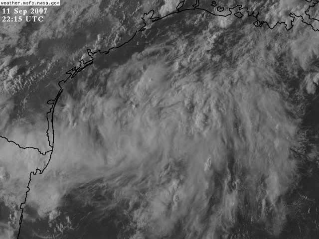
On the one hand, while the vis looks as good as it did all day, the cloud tops have really warmed.
0 likes
-
HURAKAN

- Professional-Met

- Posts: 46084
- Age: 39
- Joined: Thu May 20, 2004 4:34 pm
- Location: Key West, FL
- Contact:
Station 42002
25.17 N 94.42 W (25°10'00" N 94°25'00" W)
4:50 pm SW ( 234 deg ) 8.4 kts
4:40 pm SW ( 231 deg ) 9.3 kts
4:30 pm SW ( 229 deg ) 9.9 kts
4:20 pm SW ( 227 deg ) 9.5 kts
4:10 pm SW ( 223 deg ) 9.3 kts
4:00 pm SW ( 229 deg ) 9.1 kts
Station 42020
26.96 N 96.7 W (26°57'59" N 96°41'42" W)
4:50 pm NNE ( 16 deg ) 14.0 kts
4:40 pm N ( 3 deg ) 12.4 kts
4:30 pm N ( 357 deg ) 14.0 kts
4:20 pm N ( 358 deg ) 16.1 kts
4:10 pm NNE ( 12 deg ) 18.1 kts
4:00 pm N ( 10 deg ) 18.3 kts
http://www.ndbc.noaa.gov/maps/WestGulf.shtml
0 likes
Re: Invest 90L up again,West GOM-Discussion & Images
Looks like it's trying to wrap directly south of the TX/LA border
http://www.ssd.noaa.gov/goes/east/gmex/loop-rgb.html
http://www.ssd.noaa.gov/goes/east/gmex/loop-rgb.html
0 likes
-
jasons2k
- Storm2k Executive
- Posts: 8290
- Age: 52
- Joined: Wed Jul 06, 2005 12:32 pm
- Location: The Woodlands, TX
Re: Invest 90L up again,West GOM-Discussion & Images
Here a nice little tidbit from Victoria, TX:
...THE VICTORIA CLIMATE SUMMARY FOR SEPTEMBER 11 2007...
VALID TODAY AS OF 0400 PM LOCAL TIME.
PRECIPITATION (IN)
SINCE JAN 1 64.38
NORMAL VALUE 27.44
DEPARTURE FROM NORMAL +36.94
...THE VICTORIA CLIMATE SUMMARY FOR SEPTEMBER 11 2007...
VALID TODAY AS OF 0400 PM LOCAL TIME.
PRECIPITATION (IN)
SINCE JAN 1 64.38
NORMAL VALUE 27.44
DEPARTURE FROM NORMAL +36.94
0 likes
-
Ed Mahmoud
Re: Invest 90L up again,West GOM-Discussion & Images
I will say this, I've seen NHC issue updated tasking in the afternoon for aircraft recon, and the fact they aren't doing it for this suggests the people that know best don't think this will ever be more than a low end TC.
IMHO.
IMHO.
0 likes
-
cycloneye

- Admin
- Posts: 149275
- Age: 69
- Joined: Thu Oct 10, 2002 10:54 am
- Location: San Juan, Puerto Rico
Re: Invest 90L up again,West GOM-Discussion & Images
Stratosphere747 wrote:Sorry to go off-topic. I had asked a question, and for whatever reason it was deleted.
In this case why not just move and rename the threads with an invest such as this. Sure would be much easier to keep track of the previous discussions that were going on.
The link to the post 90L thread is at the first post.
0 likes
-
Extremeweatherguy

- Category 5
- Posts: 11095
- Joined: Mon Oct 10, 2005 8:13 pm
- Location: Florida
Re: Invest 90L up again,West GOM-Discussion & Images
Good point. However, I think we are in diurnal minimum right now..so warmer cloud tops are normal. I would expect a cooling in cloud tops again overnight once we are back closer to the diurnal maximum.Ed Mahmoud wrote:On the one hand, while the vis looks as good as it did all day, the cloud tops have really warmed.
0 likes
-
Stratosphere747
- Category 5
- Posts: 3772
- Joined: Thu Sep 11, 2003 8:34 pm
- Location: Surfside Beach/Freeport Tx
- Contact:
-
jaxfladude
- Category 5
- Posts: 1249
- Joined: Wed Aug 24, 2005 9:36 pm
- Location: Jacksonville, Fla
Re: Invest 90L up again,West GOM-Discussion & Images
This system if it gets to a TS had better drop it's rain and move on out.
Texas in still to wet for more rain...
Texas in still to wet for more rain...
0 likes
Looks like the cold front is approaching the Texas coast...I can't see this system moving ashore in Texas...possibly Louisiana
Click here, then select "NWS Fronts":
http://www.ssd.noaa.gov/goes/east/gmex/loop-rgb.html
Low level steeting map
http://cimss.ssec.wisc.edu/tropic/real- ... g8dlm1.GIF
Click here, then select "NWS Fronts":
http://www.ssd.noaa.gov/goes/east/gmex/loop-rgb.html
Low level steeting map
http://cimss.ssec.wisc.edu/tropic/real- ... g8dlm1.GIF
0 likes
-
jasons2k
- Storm2k Executive
- Posts: 8290
- Age: 52
- Joined: Wed Jul 06, 2005 12:32 pm
- Location: The Woodlands, TX
Re:
rockyman wrote:Looks like the cold front is approaching the Texas coast...I can't see this system moving ashore in Texas...possibly Louisiana
Front lifts out/washes out tomorrow. Steering flow is nill and if anything, increases from S-N as the next front approaches this weekend.
0 likes
Who is online
Users browsing this forum: No registered users and 105 guests