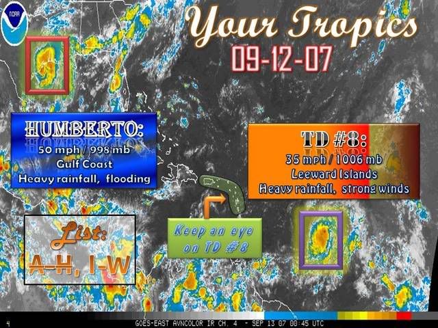
Tropical Depression HUMBERTO Discussion & Images
Moderator: S2k Moderators
The 00Z sounding from Corpus Christi does show some dry air above 600mb, but it is not that dry (http://www.rap.ucar.edu/weather/upper/crp.gif). Rather, there is ~15knots of SWly shear impinging on the storm. This is evident by the classic convective asymmetry with the strongest convection downshear. The erosion you are seeing is more of a dynamical forcing rather than dry air eating the convection away, in my opinion.
0 likes
- Sean in New Orleans
- Category 5

- Posts: 1794
- Joined: Thu Aug 28, 2003 7:26 pm
- Location: New Orleans, LA 30.0N 90.0W
- Contact:
Bob Breck is on right now....he has it coming in around LA/TX border and then traversing S. Louisiana over the Northshore area of New Orleans. His main concern is it is moving very slow and he has a small concern it could get stuck over S. Louisiana until the front pushes it out on the weekend. But, he doesn't sound concerned about it at all...in fact, he didn't even open the weather with Humberto. He opened with the depression out in the Atlantic that is basically "stationery."
0 likes
Re: T.S.HUMBERTO (GOM): Discussion & Images:7 PM CDT page 36
The center looks like it's clearing out on radar again. Thunderstorm have also increased around the center:
http://radar.weather.gov/radar.php?prod ... H&loop=yes
http://radar.weather.gov/radar.php?prod ... H&loop=yes
0 likes
Re: T.S.HUMBERTO (GOM): Discussion & Images:7 PM CDT page 36
Tampa Bay Hurricane wrote:Kudos to Joe Bastardi- nailed the formation of gabrielle
as well as humberto. His skills deserve respect.
IMO he is willing to go out on a limb at the risk of being wrong, and I admire that
0 likes
- WindRunner
- Category 5

- Posts: 5803
- Age: 35
- Joined: Fri Jul 29, 2005 8:07 pm
- Location: Warrenton, VA, but Albany, NY for school
- Contact:
Drawing a 10dbZ isosurface on the Houston radar shows a pretty well defined eye . . . to be honest, even the 5dbZ level shows it pretty well.

Combine that with the fact that the lightning is on the increase in the NW quad, I'd say it's hardly done strengthening at this point.
And since I took this screenshot, several dozen more strikes have been recorded further to the west of those below.


Combine that with the fact that the lightning is on the increase in the NW quad, I'd say it's hardly done strengthening at this point.
And since I took this screenshot, several dozen more strikes have been recorded further to the west of those below.

0 likes
-
Bailey1777
- S2K Supporter

- Posts: 962
- Joined: Mon Jul 31, 2006 6:23 pm
- Location: Houston, Texas
Re: T.S.HUMBERTO (GOM): Discussion & Images:7 PM CDT page 36
11pm Advisory, has winds at 55kts.
0 likes
-
fasterdisaster
- Category 5

- Posts: 1868
- Joined: Mon Sep 19, 2005 4:41 pm
- Location: Miami, Florida
Re: T.S.HUMBERTO (GOM): Discussion & Images:7 PM CDT page 36
Thunder44 wrote:11pm Advisory, has winds at 55kts.
WHOA!
0 likes
- Extremeweatherguy
- Category 5

- Posts: 11095
- Joined: Mon Oct 10, 2005 8:13 pm
- Location: Florida
- Evil Jeremy
- S2K Supporter

- Posts: 5463
- Age: 32
- Joined: Mon Apr 10, 2006 2:10 pm
- Location: Los Angeles, CA
-
Brent
- S2K Supporter

- Posts: 38730
- Age: 37
- Joined: Sun May 16, 2004 10:30 pm
- Location: Tulsa Oklahoma
- Contact:
Re: T.S.HUMBERTO (GOM): Discussion & Images:10 PM CDT page 44
NATIONAL WEATHER SERVICE DOPPLER RADAR OBSERVATIONS INDICATE THAT
THE MAXIMUM SUSTAINED WINDS HAVE INCREASED TO NEAR 65 MPH...100
KM/HR...WITH HIGHER GUSTS. SOME ADDITIONAL STRENGTHENING IS
POSSIBLE OVER THE NEXT SEVERAL HOURS...AND WINDS COULD BE
APPROACHING HURRICANE FORCE OVER A SMALL AREA CLOSE TO WHERE THE
CENTER CROSSES THE COAST.
THE MAXIMUM SUSTAINED WINDS HAVE INCREASED TO NEAR 65 MPH...100
KM/HR...WITH HIGHER GUSTS. SOME ADDITIONAL STRENGTHENING IS
POSSIBLE OVER THE NEXT SEVERAL HOURS...AND WINDS COULD BE
APPROACHING HURRICANE FORCE OVER A SMALL AREA CLOSE TO WHERE THE
CENTER CROSSES THE COAST.
Last edited by Brent on Wed Sep 12, 2007 9:41 pm, edited 1 time in total.
0 likes
- WindRunner
- Category 5

- Posts: 5803
- Age: 35
- Joined: Fri Jul 29, 2005 8:07 pm
- Location: Warrenton, VA, but Albany, NY for school
- Contact:
Re: T.S.HUMBERTO (GOM): Discussion & Images:7 PM CDT page 36
Thunder44 wrote:11pm Advisory, has winds at 55kts.
That's appropriate, considering what recon found.
Also, as another item of note, TS-force winds were observed at the Galveston pier at 0200z.
0 likes
-
fasterdisaster
- Category 5

- Posts: 1868
- Joined: Mon Sep 19, 2005 4:41 pm
- Location: Miami, Florida
-
Stormcenter
- S2K Supporter

- Posts: 6689
- Joined: Wed Sep 03, 2003 11:27 am
- Location: Houston, TX
Re: T.S.HUMBERTO (GOM): Discussion & Images:10 PM CDT page 44
Another pretty good burst of convection over the center.
So much for the "dry air".
http://www.ssd.noaa.gov/goes/flt/t1/loop-avn.html
So much for the "dry air".
http://www.ssd.noaa.gov/goes/flt/t1/loop-avn.html
0 likes
Re: T.S.HUMBERTO (GOM): Discussion & Images:10 PM CDT page 44
Brent wrote:NATIONAL WEATHER SERVICE DOPPLER RADAR OBSERVATIONS INDICATE THAT
THE MAXIMUM SUSTAINED WINDS HAVE INCREASED TO NEAR 65 MPH...100
KM/HR...WITH HIGHER GUSTS. SOME ADDITIONAL STRENGTHENING IS
POSSIBLE OVER THE NEXT SEVERAL HOURS...AND WINDS COULD BE
APPROACHING HURRICANE FORCE OVER A SMALL AREA CLOSE TO WHERE THE
CENTER CROSSES THE COAST.
They don't really say it could become an actual hurricane.
0 likes
- Category 5
- Category 5

- Posts: 10074
- Age: 36
- Joined: Sun Feb 11, 2007 10:00 pm
- Location: New Brunswick, NJ
- Contact:
Re: T.S.HUMBERTO (GOM): Discussion & Images:10 PM CDT page 44
I think they need to issue a Hurricane Watch.
0 likes
-
fasterdisaster
- Category 5

- Posts: 1868
- Joined: Mon Sep 19, 2005 4:41 pm
- Location: Miami, Florida
Who is online
Users browsing this forum: No registered users and 21 guests


