Model Runs & Discussions of GOM-Bahamas

This is the general tropical discussion area. Anyone can take their shot at predicting a storms path.

Moderator: S2k Moderators

Forum rules

The posts in this forum are NOT official forecasts and should not be used as such. They are just the opinion of the poster and may or may not be backed by sound meteorological data. They are NOT endorsed by any professional institution or STORM2K. For official information, please refer to products from the National Hurricane Center and National Weather Service.

Help Support Storm2K
Message
Author
User avatar
Chacor
Category 5
Category 5
Posts: 10229
Joined: Mon Oct 02, 2006 10:43 pm
Location: Singapore

#381 Postby Chacor » Sun Sep 16, 2007 10:45 am

Code: Select all

385
NOUS42 KNHC 161530
WEATHER RECONNAISSANCE FLIGHTS
CARCAH, NATIONAL HURRICANE CENTER, MIAMI, FL.
1130 AM EDT SUN 16 SEPTEMBER 2007
SUBJECT: TROPICAL CYCLONE PLAN OF THE DAY (TCPOD)
         VALID 17/1100Z TO 18/1100Z SEPTEMBER 2007
         TCPOD NUMBER.....07-115

I. ATLANTIC REQUIREMENTS
   1. TROPICAL STORM INGRID
      FLIGHT ONE                    FLIGHT TWO
      A. 18/0000Z                   A. 18/1200Z
      B. NOAA3 0708A INGRID         B. NOAA2 0808A INGRID
      C. 17/2000Z                   C. 18/0800Z
      D. 19.2N 61.3W                D. 20.0N 62.2W
      E. 17/2145Z TO 18/0230Z       E. 18/1000Z TO 18/1500Z
      F. SFC TO 10,000 FT           F. SFC TO 10,000FT

   2. SUCCEEDING DAY OUTLOOK: CONTINUE 12 HRLY MISSIONS.

   3. SUSPECT AREA SOUTH OF JAMAICA
      FLIGHT ONE                    FLIGHT TWO
      A. 17/2000Z                   A. 18/0600Z
      B. AFXXX 01IIA                B. AFXXX 0210A CYCLONE
      C. 17/1600Z                   C. 18/0200Z
      D. 16.0N 76.0W                D. 17.5N 78.5W
      E. 17/1900Z TO 18/0000Z       E. 18/0500Z TO 18/1100Z
      F. SFC TO 10,000FT            F. SFC TO 10,000FT

    4. SUCCEEDING DAY OUTLOOK: CONTINUE 6HRLY FIXES IF SYSTEM
       IS A THREAT

II.PACIFIC REQUIREMENTS
   1. NEGATIVE RECONNAISSANCE REQUIREMENTS.
   2. OUTLOOK FOR SUCCEEDING DAY.....NEGATIVE.
                           WVW


They're flying.
0 likes   

RL3AO
Moderator-Pro Met
Moderator-Pro Met
Posts: 16308
Joined: Thu Jun 14, 2007 10:03 pm
Location: NC

#382 Postby RL3AO » Sun Sep 16, 2007 10:45 am

Interesting, flights planned.
0 likes   

User avatar
Vortex
S2K Supporter
S2K Supporter
Posts: 4644
Age: 53
Joined: Fri Aug 01, 2003 9:34 pm
Location: Hilton Head, SC

#383 Postby Vortex » Sun Sep 16, 2007 10:47 am

I didn't expect that so soon...
0 likes   

CrazyC83
Professional-Met
Professional-Met
Posts: 34009
Joined: Tue Mar 07, 2006 11:57 pm
Location: Deep South, for the first time!

#384 Postby CrazyC83 » Sun Sep 16, 2007 10:56 am

Wow, a Recon when it hasn't been declared an Invest yet? This should be 93L or 94L (depending on the east Atlantic wave) soon...
0 likes   

User avatar
ROCK
Category 5
Category 5
Posts: 9485
Age: 54
Joined: Tue Aug 17, 2004 7:30 am
Location: Kemah, Texas

Re: Models jumping on SW Carib=Recon for Monday

#385 Postby ROCK » Sun Sep 16, 2007 11:05 am

that is odd? METS any idea what this is about? flying into an invest is one thing but a batch of t-storms.......
0 likes   

User avatar
HURAKAN
Professional-Met
Professional-Met
Posts: 46086
Age: 38
Joined: Thu May 20, 2004 4:34 pm
Location: Key West, FL
Contact:

#386 Postby HURAKAN » Sun Sep 16, 2007 11:05 am

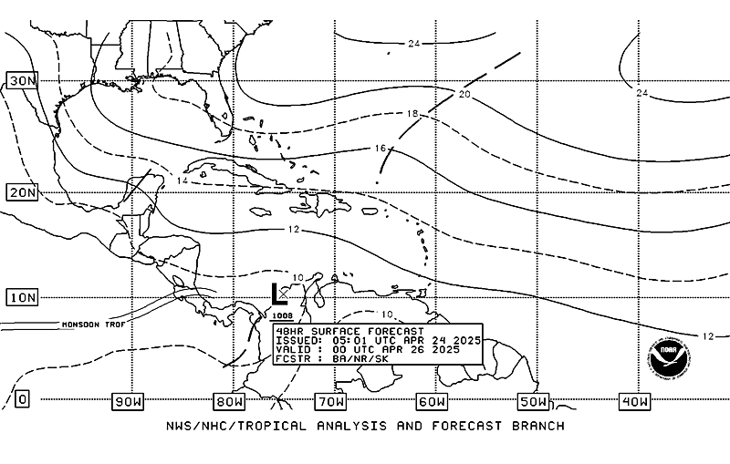
48 HRS:

Image

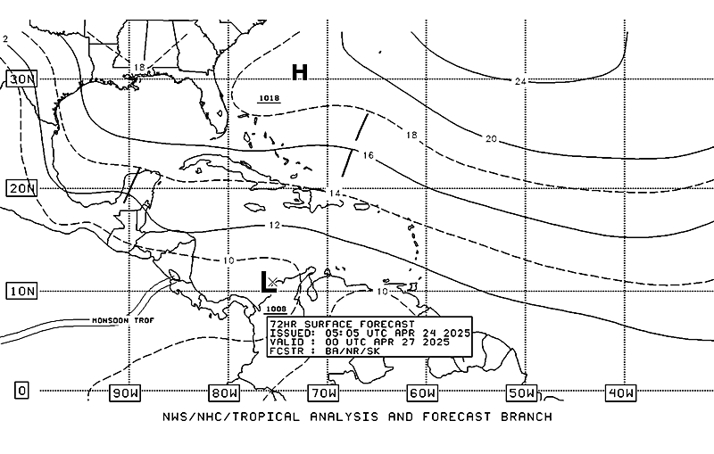
72 HRS:

Image
0 likes   

RL3AO
Moderator-Pro Met
Moderator-Pro Met
Posts: 16308
Joined: Thu Jun 14, 2007 10:03 pm
Location: NC

#387 Postby RL3AO » Sun Sep 16, 2007 11:07 am

It is probably better to be prepared since the models are forecasting development. They can cancel the flights easily.
0 likes   

User avatar
eaglegirl
S2K Supporter
S2K Supporter
Posts: 60
Joined: Sun Sep 09, 2007 10:14 am
Location: Tallahassee, FL
Contact:

Re:

#388 Postby eaglegirl » Sun Sep 16, 2007 11:13 am

Steve wrote:Still interested by 2 impending Korea hits with recurves around the back side of Japan. If I remember teleconnection 101, that would seem to indicate 2 Florida hits, possibly the second one (the one by Seoul) hitting much farther up the coast or the Panhandle. This teleconnection shows ridging poking into Japan which is why the storms hit Korea. But I still think it teleconnects to a transient trough or weaker high pressure (assuming the storms go as predicted).

Nari basically comes right out of the south while the second storm, Wipha almost hits Shanghai.

Just something to watch. Now I'm going back to sleep for another 5 hours.

Steve


I should know the answer to my question... but, I'm drawing a complete blank. :(

A few years ago, we had 2-3 systems following each other like a parade tracking toward the US.

The satellite images of the systems showing them all together were spectacular and breathtakingly beautiful.

Does anyone remember the year and the names of the systems?

Thanks :)
0 likes   

User avatar
ROCK
Category 5
Category 5
Posts: 9485
Age: 54
Joined: Tue Aug 17, 2004 7:30 am
Location: Kemah, Texas

Re:

#389 Postby ROCK » Sun Sep 16, 2007 11:16 am

RL3AO wrote:It is probably better to be prepared since the models are forecasting development. They can cancel the flights easily.


yeah maybe they are thinking since they are on their way to Igrid why not do a fly by.....
0 likes   

Stratosphere747
Category 5
Category 5
Posts: 3772
Joined: Thu Sep 11, 2003 8:34 pm
Location: Surfside Beach/Freeport Tx
Contact:

Re: Re:

#390 Postby Stratosphere747 » Sun Sep 16, 2007 11:18 am

ROCK wrote:
RL3AO wrote:It is probably better to be prepared since the models are forecasting development. They can cancel the flights easily.


yeah maybe they are thinking since they are on their way to Igrid why not do a fly by.....


Two different planes and missions.
0 likes   

User avatar
canegrl04
Category 5
Category 5
Posts: 2486
Joined: Thu Aug 26, 2004 5:37 pm
Location: Texas

Re: Models jumping on SW Carib=Recon for Monday

#391 Postby canegrl04 » Sun Sep 16, 2007 11:21 am

Since all the models are in agreement there will be devel0pment,and the threat will be to the US,I guess they take it seriously enough to investigate.It should become an invest within the next 24 hours.Maybe after they fly over it
Last edited by canegrl04 on Sun Sep 16, 2007 11:25 am, edited 1 time in total.
0 likes   

User avatar
ROCK
Category 5
Category 5
Posts: 9485
Age: 54
Joined: Tue Aug 17, 2004 7:30 am
Location: Kemah, Texas

Re: Re:

#392 Postby ROCK » Sun Sep 16, 2007 11:22 am

Stratosphere747 wrote:
ROCK wrote:
RL3AO wrote:It is probably better to be prepared since the models are forecasting development. They can cancel the flights easily.


yeah maybe they are thinking since they are on their way to Igrid why not do a fly by.....


Two different planes and missions.


thanks Strat...didnt see that... :D
0 likes   

User avatar
Recurve
Category 5
Category 5
Posts: 1640
Joined: Tue Aug 16, 2005 8:59 pm
Location: St. Petersburg, FL

Re: Models jumping on SW Carib=Recon for Monday

#393 Postby Recurve » Sun Sep 16, 2007 11:24 am

Except there's nothing there yet. Isn't it still just thunderstorms over the coast, and a wave approaching from the east? No low turning in the vicinity we've been talking about. And there are several UL votmax around, shear looks like it will be tricky.

NOT an official forecast.
0 likes   

User avatar
Tampa Bay Hurricane
Category 5
Category 5
Posts: 5597
Age: 37
Joined: Fri Jul 22, 2005 7:54 pm
Location: St. Petersburg, FL

Re:

#394 Postby Tampa Bay Hurricane » Sun Sep 16, 2007 11:25 am

HURAKAN wrote:48 HRS:

Image

72 HRS:

Image


YES!!!! A strong tropical Wave Axis with the North Portion over florida!!! The breezes will
pick up with those waves...we could have gusty winds of
25-35 mph with that Wave!!! And some heavy rains behind it!!!
I always love it when a strong NE wind drives large waves on the
western side of tampa bay.

Thanks for posting that wave image Hurakan. It's got me so excited :cheesy: :cheesy: :cheesy:
Last edited by Tampa Bay Hurricane on Sun Sep 16, 2007 11:27 am, edited 2 times in total.
0 likes   

Stratosphere747
Category 5
Category 5
Posts: 3772
Joined: Thu Sep 11, 2003 8:34 pm
Location: Surfside Beach/Freeport Tx
Contact:

#395 Postby Stratosphere747 » Sun Sep 16, 2007 11:26 am

I think recon was scheduled "just in case." As many know you just don't ring the crew and all of a sudden fly.

Could easily be called off as well.
0 likes   

User avatar
hurricanetrack
HurricaneTrack.com
HurricaneTrack.com
Posts: 1781
Joined: Tue Dec 02, 2003 10:46 pm
Location: Wilmington, NC
Contact:

#396 Postby hurricanetrack » Sun Sep 16, 2007 11:29 am

Gotta spend budeted money too or it could be lost....maybe?
0 likes   

RL3AO
Moderator-Pro Met
Moderator-Pro Met
Posts: 16308
Joined: Thu Jun 14, 2007 10:03 pm
Location: NC

Re:

#397 Postby RL3AO » Sun Sep 16, 2007 11:31 am

hurricanetrack wrote:Gotta spend budeted money too or it could be lost....maybe?


I think it is a better safe than sorry thing. You can't just call up the crew and say "flight in 1 hour". They need 12-24 hours time to prepare. If it doesn't look good tomorrow they will cancel.
0 likes   

njweather
Tropical Storm
Tropical Storm
Posts: 169
Joined: Fri Aug 17, 2007 10:45 pm
Location: Washington, DC

Re: Models jumping on SW Carib=Recon for Monday

#398 Postby njweather » Sun Sep 16, 2007 11:34 am

Many people perceived Humberto as a surprise-storm. Of course, many on this board alone were watching it one week in advance, but the TV met community really didn't pick up on it till later and that's because there wasn't enough solid data on it. I assume they're trying to prevent such a scenario...
0 likes   

User avatar
Tampa Bay Hurricane
Category 5
Category 5
Posts: 5597
Age: 37
Joined: Fri Jul 22, 2005 7:54 pm
Location: St. Petersburg, FL

#399 Postby Tampa Bay Hurricane » Sun Sep 16, 2007 11:41 am

Convection is exploding
on that eastern caribbean tropical wave:
Image
Image
0 likes   

Stratosphere747
Category 5
Category 5
Posts: 3772
Joined: Thu Sep 11, 2003 8:34 pm
Location: Surfside Beach/Freeport Tx
Contact:

Re: Models jumping on SW Carib

#400 Postby Stratosphere747 » Sun Sep 16, 2007 11:48 am

Convection is not exploding, it is actually waning.
0 likes   


Return to “Talkin' Tropics”

Who is online

Users browsing this forum: Hurrilurker, lolitx and 43 guests