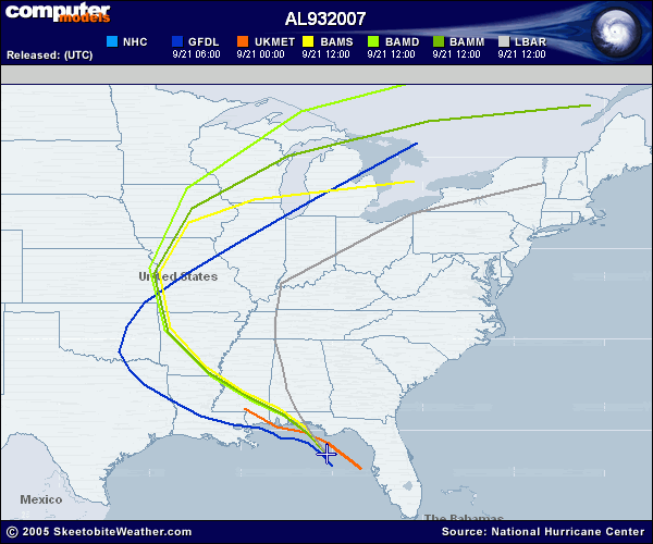
The rarest picture in the history of Hurricane forecasting..
Moderator: S2k Moderators
Forum rules

The posts in this forum are NOT official forecasts and should not be used as such. They are just the opinion of the poster and may or may not be backed by sound meteorological data. They are NOT endorsed by any professional institution or STORM2K. For official information, please refer to products from the National Hurricane Center and National Weather Service.
-
Category 5

- Category 5

- Posts: 10074
- Age: 35
- Joined: Sun Feb 11, 2007 10:00 pm
- Location: New Brunswick, NJ
- Contact:


-
oyster_reef

- Tropical Storm

- Posts: 123
- Joined: Tue Aug 14, 2007 3:05 pm
- Location: Alabama
Re: The rarest picture in the history of Hurricane forecasting..
BAMS BAMD and BAMD had it right... not LBAR...
And by the way... LBAR was the ONLY model that was even close
with Katrina 4 days out. It was by its self by 200+ miles.
And by the way... LBAR was the ONLY model that was even close
with Katrina 4 days out. It was by its self by 200+ miles.
0 likes
Who is online
Users browsing this forum: No registered users and 176 guests