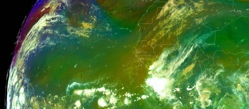
Well Organized Low Pressure SSW of Cape Verde Islands

This is the general tropical discussion area. Anyone can take their shot at predicting a storms path.

Moderator: S2k Moderators

Forum rules

The posts in this forum are NOT official forecasts and should not be used as such. They are just the opinion of the poster and may or may not be backed by sound meteorological data. They are NOT endorsed by any professional institution or STORM2K. For official information, please refer to products from the National Hurricane Center and National Weather Service.

Help Support Storm2K
Message
Author
RL3AO
Moderator-Pro Met
Moderator-Pro Met
Posts: 16308
Joined: Thu Jun 14, 2007 10:03 pm
Location: NC

Re: Re:

#101 Postby RL3AO » Sat Sep 22, 2007 6:03 pm

cycloneye wrote:
RL3AO wrote:Watch out San Ciriaco hurricane, someone is coming for your ACE record! :lol:


Dont remember me that one here.


:lol:

http://en.wikipedia.org/wiki/1899_Hurricane_San_Ciriaco

Longest lasting storm in the Atlantic and highest ACE of any Atlantic storm (73.4).
0 likes   

RL3AO
Moderator-Pro Met
Moderator-Pro Met
Posts: 16308
Joined: Thu Jun 14, 2007 10:03 pm
Location: NC

#102 Postby RL3AO » Sat Sep 22, 2007 6:04 pm

Can someone fix the title. Or is Low pressure descriptive enough?
0 likes   

HUC
Category 2
Category 2
Posts: 590
Joined: Fri Oct 03, 2003 3:48 pm
Location: Basse-Terre Guadeloupe

Re: Low Pressure South of Cape Verde Islands

#103 Postby HUC » Sat Sep 22, 2007 6:07 pm

If you look at the buoy 13001 http://www.ndbc.noaa.gov/station_page.php?station=13001, and 31006, http://www.ndbc.noaa.gov/station_page.php?station=31006 you can observe the circulationand pressure.CLEARLY A LOW
0 likes   

RL3AO
Moderator-Pro Met
Moderator-Pro Met
Posts: 16308
Joined: Thu Jun 14, 2007 10:03 pm
Location: NC

#104 Postby RL3AO » Sat Sep 22, 2007 6:09 pm

Theres obviously a circulation and maybe a close circulation according to quikscat.
0 likes   

HUC
Category 2
Category 2
Posts: 590
Joined: Fri Oct 03, 2003 3:48 pm
Location: Basse-Terre Guadeloupe

Re: Low Pressure S of CV Islands=18z GFS to GOM

#105 Postby HUC » Sat Sep 22, 2007 6:11 pm

hEPS?I THINK YOU HAVE TO LOOK AT THE NORTH BUOY?WITH NE WINDS..THE SOUTH BUOY IS WAY TO SOUTH AND THE SSW WINDS ARE SURELY MORE RELATED TO THE AFRICAN MOOSON!!!
0 likes   

User avatar
HURAKAN
Professional-Met
Professional-Met
Posts: 46086
Age: 38
Joined: Thu May 20, 2004 4:34 pm
Location: Key West, FL
Contact:

#106 Postby HURAKAN » Sat Sep 22, 2007 6:20 pm

Looking very good considering DMIN.

Image
0 likes   

njweather
Tropical Storm
Tropical Storm
Posts: 169
Joined: Fri Aug 17, 2007 10:45 pm
Location: Washington, DC

Re: Low Pressure South of Cape Verde Islands

#107 Postby njweather » Sat Sep 22, 2007 6:23 pm

Title should probably be adjusted to best reflect the organized/developing nature of the system...


HURAKAN wrote:Looking very good considering DMIN.

Image


Yea... I wonder how it'll look during DMAX. :D :cheesy: :cheesy:
0 likes   

User avatar
cycloneye
Admin
Admin
Posts: 145862
Age: 69
Joined: Thu Oct 10, 2002 10:54 am
Location: San Juan, Puerto Rico

Re: Well Organized Low Pressure South of Cape Verde Islands

#108 Postby cycloneye » Sat Sep 22, 2007 6:31 pm

Added to title (Well Organized) as all indications are like it is.
0 likes   

User avatar
Gustywind
Category 5
Category 5
Posts: 12334
Joined: Mon Sep 03, 2007 7:29 am
Location: Baie-Mahault, GUADELOUPE

Re:

#109 Postby Gustywind » Sat Sep 22, 2007 6:32 pm

HURAKAN wrote:Looking very good considering DMIN.

Image


Very good, increasing trend down the road..... http://www.nrlmry.navy.mil/sat-bin/disp ... C_SCALE=15
0 likes   

User avatar
punkyg
Category 2
Category 2
Posts: 770
Joined: Mon Apr 23, 2007 7:37 pm
Location: sanford florida

#110 Postby punkyg » Sat Sep 22, 2007 6:34 pm

Man for some reason this storm is reminding me of the first 92L of this year i think that was the first cape verde wave that was showing signs of developing, but dissipated the day after. oh how i wished that waved developed.
0 likes   

jhamps10

#111 Postby jhamps10 » Sat Sep 22, 2007 7:10 pm

here's what is funny, this thing is taking up the ENTIRE GFS run tracking this thing. what is that, some 15 days?

anyway, I honestly think that it could be a TD right now, if not now tomorrow for sure.
0 likes   

User avatar
HURAKAN
Professional-Met
Professional-Met
Posts: 46086
Age: 38
Joined: Thu May 20, 2004 4:34 pm
Location: Key West, FL
Contact:

#112 Postby HURAKAN » Sat Sep 22, 2007 7:18 pm

TWD 805:

A 1010 MB LOW IS LOCATED S OF THE CAPE VERDE ISLANDS NEAR 6N22W
MOVING W AT 15 KT. THIS LOW HAS THE POTENTIAL TO BECOME A
TROPICAL DEPRESSION WITHIN THE NEXT 48 HOURS. SCATTERED
MODERATE TO ISOLATED STRONG CONVECTION IS IS FROM 4N-11N BETWEEN
23W-27W.
0 likes   

User avatar
cycloneye
Admin
Admin
Posts: 145862
Age: 69
Joined: Thu Oct 10, 2002 10:54 am
Location: San Juan, Puerto Rico

Re: Well Organized Low Pressure South of Cape Verde Islands

#113 Postby cycloneye » Sat Sep 22, 2007 7:20 pm

The Latest at 23:45 UTC

Image
0 likes   

jhamps10

#114 Postby jhamps10 » Sat Sep 22, 2007 7:24 pm

gee, looks good for DMIN.

anyone besides me shocked to not see this get an invest yet?
0 likes   

MiamiensisWx

Re: Well Organized Low Pressure South of Cape Verde Islands

#115 Postby MiamiensisWx » Sat Sep 22, 2007 7:26 pm

It meets all parameters for an INVEST classification (i.e. convective maintenance, sufficient organization, low-level structure, and a closed LLC per QuikSCAT). It's much closer to a TD, and there isn't a wind limit that should be met in order to allow TD classification. Do you have any thoughts as to why the TPC's various outlets (at NRL) haven't listed this wave as an INVEST? Finally, check this loop.

Click here

RL3AO wrote:It will be here soon. Calm down. 8-)

I don't have a beef with the NHC. I was asking a question.
Last edited by MiamiensisWx on Sat Sep 22, 2007 7:29 pm, edited 2 times in total.
0 likes   

RL3AO
Moderator-Pro Met
Moderator-Pro Met
Posts: 16308
Joined: Thu Jun 14, 2007 10:03 pm
Location: NC

#116 Postby RL3AO » Sat Sep 22, 2007 7:27 pm

It will be here soon. Calm down. 8-)
0 likes   

HUC
Category 2
Category 2
Posts: 590
Joined: Fri Oct 03, 2003 3:48 pm
Location: Basse-Terre Guadeloupe

Re: Well Organized Low Pressure South of Cape Verde Islands

#117 Postby HUC » Sat Sep 22, 2007 7:28 pm

Finally,the buoy near 4°N 23°W,is near the low,and the WSW winds are in relation with the low circulation.... :D 6°N,that's way south :eek:
0 likes   

User avatar
Gustywind
Category 5
Category 5
Posts: 12334
Joined: Mon Sep 03, 2007 7:29 am
Location: Baie-Mahault, GUADELOUPE

#118 Postby Gustywind » Sat Sep 22, 2007 7:29 pm

000
AXNT20 KNHC 230015
TWDAT

TROPICAL WEATHER DISCUSSION
NWS TPC/NATIONAL HURRICANE CENTER MIAMI FL
805 PM EDT SAT SEP 22 2007

TROPICAL WEATHER DISCUSSION FOR NORTH AMERICA...CENTRAL
AMERICA...THE GULF OF MEXICO...THE CARIBBEAN SEA...NORTHERN
SECTIONS OF SOUTH AMERICA...AND THE ATLANTIC OCEAN TO THE
AFRICAN COAST FROM THE EQUATOR TO 32N. THE FOLLOWING INFORMATION
IS BASED ON SATELLITE IMAGERY...METEOROLOGICAL ANALYSIS...
WEATHER OBSERVATIONS...AND RADAR.

BASED ON 1800 UTC SURFACE ANALYSIS AND SATELLITE IMAGERY THROUGH
2315 UTC.

...TROPICAL WAVES AND TROPICAL LOWS...
A 1010 MB LOW IS LOCATED S OF THE CAPE VERDE ISLANDS NEAR 6N22W
MOVING W AT 15 KT. THIS LOW HAS THE POTENTIAL TO BECOME A
TROPICAL DEPRESSION WITHIN THE NEXT 48 HOURS. SCATTERED
MODERATE TO ISOLATED STRONG CONVECTION IS IS FROM 4N-11N BETWEEN
23W-27W.
0 likes   

Matt-hurricanewatcher

Re: Well Organized Low Pressure South of Cape Verde Islands

#119 Postby Matt-hurricanewatcher » Sat Sep 22, 2007 7:29 pm

MiamiensisWx wrote:It meets all parameters for an INVEST classification (i.e. convective maintenance, sufficient organization, low-level structure, and a closed LLC per QuikSCAT). It's much closer to a TD, and there isn't a wind limit that should be met in order to allow TD classification. Do you have any thoughts as to why the TPC's various outlets (at NRL) haven't listed this wave as an INVEST? Finally, check this loop.

Click here


I agree it should at the very least be a invest. Also notice (tropical storm) 95L that is very impressive for a invest. This appears to be centered by 5-6 north...
0 likes   

Matt-hurricanewatcher

Re: Well Organized Low Pressure South of Cape Verde Islands

#120 Postby Matt-hurricanewatcher » Sat Sep 22, 2007 7:31 pm

What is even more impressive is the center is centered no more then 6 degree's north. That is amazing for the Atlantic.
0 likes   


Return to “Talkin' Tropics”

Who is online

Users browsing this forum: caneman, Cpv17, riapal and 34 guests