Ex Tropical Depression KAREN: Discussions & Images
Moderator: S2k Moderators


Re: INVEST 96L: East Atlantic : Discussions & Images
Easy there, H. Don't count your chickens before they're hatched and what not. Besides, there's a chance that this one could wind up being Lorenzo or even (though unlikely) Melissa. Gotta be careful making images like that. 
0 likes
-
HURAKAN

- Professional-Met

- Posts: 46084
- Age: 39
- Joined: Thu May 20, 2004 4:34 pm
- Location: Key West, FL
- Contact:
Re: INVEST 96L: East Atlantic : Discussions & Images
Beam wrote:Easy there, H. Don't count your chickens before they're hatched and what not. Besides, there's a chance that this one could wind up being Lorenzo or even (though unlikely) Melissa. Gotta be careful making images like that.
ex. 94L: Not likely to become Karen as upper level winds remain unfavorable.
97L: Not organizing at the moment and upper level winds are not the best for development.
Therefore, if you're thinking of Karen forming in the near future, then 96L presents itself as the best case.
0 likes

-
HURAKAN
- Professional-Met
- Posts: 46084
- Age: 39
- Joined: Thu May 20, 2004 4:34 pm
- Location: Key West, FL
- Contact:
Re:
Chacor wrote:I think you're rather missing the point, it's not even a TC yet, not really right to stick the word "Karen" next to an image of an invest, because someone who's just browsing might treat it as real.
To eliminate the controversy I changed it. Nevertheless, since I knew it was just an invest that's why at the bottom it said that Karen was not far from the present, meaning, that it had not formed yet.
0 likes
-
cycloneye

- Admin

- Posts: 149278
- Age: 69
- Joined: Thu Oct 10, 2002 10:54 am
- Location: San Juan, Puerto Rico
Re: INVEST 96L: East Atlantic : Discussions & Images
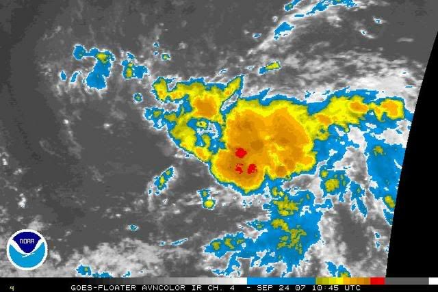
8:05 AM TWD
A 1007 MB LOW PRESSURE SYSTEM IS LOCATED ABOUT 565 NM SW OF THE
CAPE VERDE ISLANDS NEAR 8.5N31W. THIS LARGE SYSTEM CONTINUES TO
SHOW SIGNS OF ORGANIZATION...AND COULD BECOME A TROPICAL
DEPRESSION DURING THE NEXT DAY OR SO AS IT MOVES
WEST-NORTHWESTWARD NEAR 10-15 KT. A MORE CONCENTRATED AREA OF
SCATTERED MODERATE/ISOLATED STRONG CONVECTION IS NOW MOSTLY W OF
THE CENTER FROM 8N-11N BETWEEN 31W-37W. ISOLATED CLUSTERS OF
MODERATE CONVECTION ARE ELSEWHERE FROM 5N-12N BETWEEN 29W-38W.
THIS IS ONE OF THE MORE CLASSIC LOOKING CAPE VERDE SYSTEMS WE
HAVE SEEN OVER THE PAST COUPLE OF WEEKS.
$$
MW

Mike Watkins?
http://www.storm2k.org/wx/modules.php?n ... ge&pid=109
A 1007 MB LOW PRESSURE SYSTEM IS LOCATED ABOUT 565 NM SW OF THE
CAPE VERDE ISLANDS NEAR 8.5N31W. THIS LARGE SYSTEM CONTINUES TO
SHOW SIGNS OF ORGANIZATION...AND COULD BECOME A TROPICAL
DEPRESSION DURING THE NEXT DAY OR SO AS IT MOVES
WEST-NORTHWESTWARD NEAR 10-15 KT. A MORE CONCENTRATED AREA OF
SCATTERED MODERATE/ISOLATED STRONG CONVECTION IS NOW MOSTLY W OF
THE CENTER FROM 8N-11N BETWEEN 31W-37W. ISOLATED CLUSTERS OF
MODERATE CONVECTION ARE ELSEWHERE FROM 5N-12N BETWEEN 29W-38W.
THIS IS ONE OF THE MORE CLASSIC LOOKING CAPE VERDE SYSTEMS WE
HAVE SEEN OVER THE PAST COUPLE OF WEEKS.
$$
MW
Mike Watkins?
http://www.storm2k.org/wx/modules.php?n ... ge&pid=109
0 likes
Re: INVEST 96L: East Atlantic : Discussions & Images
0 likes
-
cycloneye
- Admin
- Posts: 149278
- Age: 69
- Joined: Thu Oct 10, 2002 10:54 am
- Location: San Juan, Puerto Rico
Re: INVEST 96L: East Atlantic : Discussions & Images
0 likes


Re: INVEST 96L: East Atlantic : Discussions & Images
96L might have a good shot at Karen but I think it will be a fish. The only way this might make it across is if it stays weak and doesn't develop.Especially this time of year.
0 likes
-
stormchazer

- Category 5

- Posts: 2462
- Joined: Fri Aug 29, 2003 12:00 pm
- Location: Lakeland, Florida
- Contact:
Re: INVEST 96L: East Atlantic : Discussions & Images
boca wrote:96L might have a good shot at Karen but I think it will be a fish. The only way this might make it across is if it stays weak and doesn't develop.Especially this time of year.
The fact that it is at a very low Latitude could have a bearing as well, especially if an LLC forms low, but I agree that storms forming in the East Atlantic this time of year have a good chance of recurving.
0 likes
-
Typhoon_Willie

- Category 5
- Posts: 1042
- Joined: Mon Jun 09, 2003 3:19 pm
- Location: Greenacres City, Florida

Re: INVEST 96L: East Atlantic : Discussions & Images
boca wrote:96L might have a good shot at Karen but I think it will be a fish. The only way this might make it across is if it stays weak and doesn't develop.Especially this time of year.
Hopefully its a fish.Because if it isn't, a major hurricane in the making is going to do alot of damage from the Carribean,to the US
0 likes
-
wxman57

- Moderator-Pro Met

- Posts: 23172
- Age: 68
- Joined: Sat Jun 21, 2003 8:06 pm
- Location: Houston, TX (southwest)
Re: INVEST 96L: East Atlantic : Discussions & Images
Very good rotation on satellite. About to 9N now. High pressure to the north is not nearly as strong as in late August or early September. Ridge weakens west of 50W, which should allow for a northward turn east of the Caribbean. Only question is whether the northward turn just takes it out to sea of if it's blocked and shoved back westward toward the Bahamas or SE U.S. It does look well on its way to becoming a TD by tomorrow. Probably not today.
0 likes
-
HurricaneMaster_PR

- Category 2

- Posts: 795
- Joined: Tue Jul 22, 2003 6:23 pm
- Location: San Juan, Puerto Rico
Re: INVEST 96L: East Atlantic : Discussions & Images
DATE/TIME LAT LON CLASSIFICATION STORM
24/1145 UTC 9.0N 31.3W T1.0/1.0 96L
24/1145 UTC 9.0N 31.3W T1.0/1.0 96L
0 likes
Who is online
Users browsing this forum: No registered users and 69 guests