Ex Tropical Depression KAREN: Discussions & Images

Moderator: S2k Moderators

Message
Author
jhamps10

Re:

#241 Postby jhamps10 » Mon Sep 24, 2007 4:15 pm

Cyclone1 wrote:Wow! That is one serious tropical low. Depending on how enthusiastic the NHC is a 5:30, I'd be willing to bet on TD-12 by 11 tonight.


well we were all willing to bet that this would be a TD right now, but apartently NHC and it's double standard of not upgrading storms that's further away from land even though it clearly looks like a TD to me.

and BTW, that was not a jab against the NHC, as I appreaciate their hard work, but I'm just looking at my opinion here.
0 likes   

Cyclone1
Category 5
Category 5
Posts: 2739
Age: 33
Joined: Tue Jun 12, 2007 12:03 pm
Location: Florida

Re: Re:

#242 Postby Cyclone1 » Mon Sep 24, 2007 4:20 pm

jhamps10 wrote:
Cyclone1 wrote:Wow! That is one serious tropical low. Depending on how enthusiastic the NHC is a 5:30, I'd be willing to bet on TD-12 by 11 tonight.


well we were all willing to bet that this would be a TD right now, but apartently NHC and it's double standard of not upgrading storms that's further away from land even though it clearly looks like a TD to me.

and BTW, that was not a jab against the NHC, as I appreaciate their hard work, but I'm just looking at my opinion here.


Like I said, it all depends on the TWO. It's TOO organized for the NHC to just ignore, it'll get an upgrade almost no matter what. Just when is the question.

Just my opinion
0 likes   

User avatar
HurricaneMaster_PR
Category 2
Category 2
Posts: 795
Joined: Tue Jul 22, 2003 6:23 pm
Location: San Juan, Puerto Rico

Re: INVEST 96L: East Atlantic : 5:30 PM TWO Shortly

#243 Postby HurricaneMaster_PR » Mon Sep 24, 2007 4:24 pm

TROPICAL WEATHER OUTLOOK
NWS TPC/NATIONAL HURRICANE CENTER MIAMI FL
530 PM EDT MON SEP 24 2007

FOR THE NORTH ATLANTIC...CARIBBEAN SEA AND THE GULF OF MEXICO...
THE NATIONAL HURRICANE CENTER IS ISSUING ADVISORIES ON TROPICAL
DEPRESSION JERRY...LOCATED ABOUT 870 MILES WEST-NORTHWEST OF THE
AZORES.

THERE ARE THREE AREAS OF LOW PRESSURE IN ATLANTIC BASIN THAT COULD
BECOME TROPICAL DEPRESSIONS AT ANY TIME OVER THE NEXT DAY OR SO.
THE SMALL AREA OF LOW PRESSURE OVER THE SOUTHWESTERN GULF OF MEXICO
HAS BECOME A LITTLE LESS ORGANIZED THIS AFTERNOON DUE TO
UNFAVORABLE UPPER-LEVEL WINDS. HOWEVER...THE UPPER FLOW IS EXPECTED
TO BECOME MORE FAVORABLE FOR DEVELOPMENT OVER THE NEXT DAY OR
SO...AND THIS SYSTEM COULD BECOME A TROPICAL DEPRESSION TOMORROW AS
IT DRIFTS SLOWLY AND ERRATICALLY.

AN AREA OF LOW PRESSURE ASSOCIATED WITH A TROPICAL WAVE HAS BECOME A
LITTLE BETTER DEFINED THIS AFTERNOON A SHORT DISTANCE EAST OF
MARTINIQUE IN THE WINDWARD ISLANDS. ALTHOUGH SHOWERS AND
THUNDERSTORMS WITH THIS SYSTEM ARE NOT WELL-ORGANIZED AT THIS
TIME....THIS SYSTEM COULD BECOME A TROPICAL DEPRESSION DURING THE
NEXT DAY OR TWO AS IT MOVES NORTHWESTWARD AT ABOUT 15 MPH. THE LOW
IS EXPECTED TO BRING SQUALLY WEATHER TO PORTIONS OF THE WINDWARD
AND LEEWARD ISLANDS THROUGH TUESDAY...AND INTO THE VIRGIN ISLANDS
AND PUERTO RICO BY WEDNESDAY. INTERESTS IN THESE AREAS SHOULD
MONITOR THE PROGRESS OF THIS SYSTEM.

AN AREA OF LOW PRESSURE ASSOCIATED WITH A TROPICAL WAVE IS LOCATED
ABOUT 1700 MILES EAST OF THE SOUTHERN WINDWARD ISLANDS. THIS
LARGE SYSTEM IS WELL ORGANIZED...AND WILL LIKELY BECOME A TROPICAL
DEPRESSION LATER TONIGHT AS IT MOVES WEST-NORTHWESTWARD AT ABOUT 15
MPH
.


ELSEWHERE...TROPICAL CYCLONE FORMATION IS NOT EXPECTED DURING THE
NEXT 48 HOURS.
$$
0 likes   

Cyclone1
Category 5
Category 5
Posts: 2739
Age: 33
Joined: Tue Jun 12, 2007 12:03 pm
Location: Florida

#244 Postby Cyclone1 » Mon Sep 24, 2007 4:26 pm

That's what I'm looking for! I am now willing to bet on 11:00.
0 likes   

RL3AO
Moderator-Pro Met
Moderator-Pro Met
Posts: 16308
Joined: Thu Jun 14, 2007 10:03 pm
Location: NC

#245 Postby RL3AO » Mon Sep 24, 2007 4:26 pm

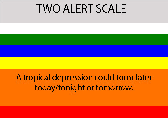
It is a mix of orange and red.

Image
0 likes   

User avatar
cycloneye
Admin
Admin
Posts: 145303
Age: 68
Joined: Thu Oct 10, 2002 10:54 am
Location: San Juan, Puerto Rico

Re: INVEST 96L: East Atlantic : 5:30 PM TWO at page 12

#246 Postby cycloneye » Mon Sep 24, 2007 4:31 pm

Image

They can upgrade strait to a Tropical Storm tonight,but being in the middle of the ocean,they can hold.
0 likes   

User avatar
southerngale
Retired Staff
Retired Staff
Posts: 27418
Joined: Thu Oct 10, 2002 1:27 am
Location: Southeast Texas (Beaumont area)

Re:

#247 Postby southerngale » Mon Sep 24, 2007 4:31 pm

RL3AO wrote:It is a mix of orange and red.

Image


Are we supposed to know what red says?
0 likes   

RL3AO
Moderator-Pro Met
Moderator-Pro Met
Posts: 16308
Joined: Thu Jun 14, 2007 10:03 pm
Location: NC

Re: Re:

#248 Postby RL3AO » Mon Sep 24, 2007 4:33 pm

southerngale wrote:
RL3AO wrote:It is a mix of orange and red.

Image


Are we supposed to know what red says?


Red is: "A tropical depression could form at anytime". To prevent being labeled a wish_caster, I stuck with orange. :D
0 likes   

Derek Ortt

#249 Postby Derek Ortt » Mon Sep 24, 2007 4:34 pm

according to that scale, it would be red level 2 as they have said a TD will likely form later tonight, not can form later tonight
0 likes   

User avatar
Cyclenall
Category 5
Category 5
Posts: 6666
Joined: Thu Jun 08, 2006 10:01 pm
Location: Ontario, Canada

Re: INVEST 96L: East Atlantic : 5:30 PM TWO Shortly

#250 Postby Cyclenall » Mon Sep 24, 2007 4:37 pm

NHC wrote:TROPICAL WEATHER OUTLOOK
NWS TPC/NATIONAL HURRICANE CENTER MIAMI FL
530 PM EDT MON SEP 24 2007

FOR THE NORTH ATLANTIC...CARIBBEAN SEA AND THE GULF OF MEXICO...
THE NATIONAL HURRICANE CENTER IS ISSUING ADVISORIES ON TROPICAL
DEPRESSION JERRY...LOCATED ABOUT 870 MILES WEST-NORTHWEST OF THE
AZORES.

THERE ARE THREE AREAS OF LOW PRESSURE IN ATLANTIC BASIN THAT COULD
BECOME TROPICAL DEPRESSIONS AT ANY TIME OVER THE NEXT DAY OR SO
.

Wow, I have never seen that before in a TWO.
0 likes   

User avatar
WindRunner
Category 5
Category 5
Posts: 5806
Age: 34
Joined: Fri Jul 29, 2005 8:07 pm
Location: Warrenton, VA, but Albany, NY for school
Contact:

#251 Postby WindRunner » Mon Sep 24, 2007 4:37 pm

Yeah . . . I think this is the first time I've seen them publically announce that they are going to start advisories six hours in advance . . .
0 likes   

RL3AO
Moderator-Pro Met
Moderator-Pro Met
Posts: 16308
Joined: Thu Jun 14, 2007 10:03 pm
Location: NC

Re: INVEST 96L: East Atlantic : 5:30 PM TWO Shortly

#252 Postby RL3AO » Mon Sep 24, 2007 4:38 pm

Cyclenall wrote:
NHC wrote:TROPICAL WEATHER OUTLOOK
NWS TPC/NATIONAL HURRICANE CENTER MIAMI FL
530 PM EDT MON SEP 24 2007

FOR THE NORTH ATLANTIC...CARIBBEAN SEA AND THE GULF OF MEXICO...
THE NATIONAL HURRICANE CENTER IS ISSUING ADVISORIES ON TROPICAL
DEPRESSION JERRY...LOCATED ABOUT 870 MILES WEST-NORTHWEST OF THE
AZORES.

THERE ARE THREE AREAS OF LOW PRESSURE IN ATLANTIC BASIN THAT COULD
BECOME TROPICAL DEPRESSIONS AT ANY TIME OVER THE NEXT DAY OR SO
.

Wow, I have never seen that before in a TWO.


I've never seen this before either.

AND WILL LIKELY BECOME A TROPICAL
DEPRESSION LATER TONIGHT AS IT MOVES WEST-NORTHWESTWARD AT ABOUT 15
MPH.
0 likes   

User avatar
MetroMike
Category 4
Category 4
Posts: 952
Joined: Sun Aug 29, 2004 8:13 pm
Location: Tampa Bay
Contact:

Re: INVEST 96L: East Atlantic : 5:30 PM TWO at page 12

#253 Postby MetroMike » Mon Sep 24, 2007 4:38 pm

If the NHC can name Jerry way out in B.F.E. why can't they classify this system?

I mean it is what it is. It does appear that it won't go Poof any time soon if thats what they are worried about. JMO.
0 likes   

User avatar
PTrackerLA
Category 5
Category 5
Posts: 5277
Age: 41
Joined: Thu Oct 10, 2002 8:40 pm
Location: Lafayette, LA

Re: INVEST 96L: East Atlantic : 5:30 PM TWO at page 12

#254 Postby PTrackerLA » Mon Sep 24, 2007 4:39 pm

Most impressive wave/low of the year, should be interesting to watch...it's HUGE!
0 likes   

Brent
S2K Supporter
S2K Supporter
Posts: 38088
Age: 36
Joined: Sun May 16, 2004 10:30 pm
Location: Tulsa Oklahoma
Contact:

Re: INVEST 96L: East Atlantic : 5:30 PM TWO at page 12

#255 Postby Brent » Mon Sep 24, 2007 4:45 pm

Don't think I've ever seen such strong wording. Defintely a TD at 11 it appears.
0 likes   

User avatar
Tampa_God
Category 1
Category 1
Posts: 333
Age: 35
Joined: Wed May 31, 2006 7:27 pm
Location: New Port Richey/Trinity, FL

Re: INVEST 96L: East Atlantic : 5:30 PM TWO at page 12

#256 Postby Tampa_God » Mon Sep 24, 2007 4:49 pm

I agree w/ everyone else. Certainly this will be classified as a TD by 11 pm. This low is the best I have seen this year so far. It's huge and circulation is flowing greatly.

Off Topic: The wave behind it, does anyone else see a rotation w/ each aswell? Most likely a Mid-Level Low, but still, maybe another invest to look into???
0 likes   

jaxfladude
Category 5
Category 5
Posts: 1249
Joined: Wed Aug 24, 2005 9:36 pm
Location: Jacksonville, Fla

Re: INVEST 96L: East Atlantic : 5:30 PM TWO at page 12

#257 Postby jaxfladude » Mon Sep 24, 2007 4:51 pm

cycloneye wrote:Image

They can upgrade strait to a Tropical Storm tonight,but being in the middle of the ocean,they can hold.

Wow!!! :double: :double: :double: :double: :double: :double: :double: :double:
0 likes   

User avatar
wxman57
Moderator-Pro Met
Moderator-Pro Met
Posts: 22978
Age: 67
Joined: Sat Jun 21, 2003 8:06 pm
Location: Houston, TX (southwest)

Re: INVEST 96L: East Atlantic : 5:30 PM TWO at page 12

#258 Postby wxman57 » Mon Sep 24, 2007 4:57 pm

MetroMike wrote:If the NHC can name Jerry way out in B.F.E. why can't they classify this system?

I mean it is what it is. It does appear that it won't go Poof any time soon if thats what they are worried about. JMO.


The NHC is typically very slow to upgrade Cape Verde systems because there is plenty of time to do so before they might impact any land areas. Usually they'll wait 12-24 hours after it's clear a TD has formed, just to make sure it won't dissipate. No problem with that. Their job isn't to please S2K forum members by upgrading a system the instant it might be a TD. ;-) If this system was in the Gulf of Mexico then that's another story, it would likely have been upgraded this morning or even yesterday because it would be an immediate threat.

I don't know why they bothered with Jerry, other than they talked about upgrading it for days beforehand. Jerry was certainly no threat to anyone. The only threat was that it would dissipate before they got a chance to name it.
0 likes   

User avatar
fci
S2K Supporter
S2K Supporter
Posts: 3324
Joined: Tue Sep 14, 2004 10:29 am
Location: Lake Worth, FL

#259 Postby fci » Mon Sep 24, 2007 4:57 pm

So, if this develops this far out, at this rather late time of year for a CV storm; how realistic is it that it would NOT take the poleward turn and be a Fish??

I know Dean and his brother Felix did not make the turn but that was way earlier in the season.

Thoughts?

BTW, I agree this thing is H U G E.
0 likes   

CrazyC83
Professional-Met
Professional-Met
Posts: 34002
Joined: Tue Mar 07, 2006 11:57 pm
Location: Deep South, for the first time!

#260 Postby CrazyC83 » Mon Sep 24, 2007 4:57 pm

I would have declared this TD12 now. That would be one great place to take a Recon into - if it weren't sitting in the middle of nowhere. I don't think fish can fly either...
0 likes   


Return to “2007”

Who is online

Users browsing this forum: No registered users and 11 guests