Tropical Wave SW of Cape Verde Islands

This is the general tropical discussion area. Anyone can take their shot at predicting a storms path.

Moderator: S2k Moderators

Forum rules

The posts in this forum are NOT official forecasts and should not be used as such. They are just the opinion of the poster and may or may not be backed by sound meteorological data. They are NOT endorsed by any professional institution or STORM2K. For official information, please refer to products from the National Hurricane Center and National Weather Service.

Help Support Storm2K
Message
Author
User avatar
Gustywind
Category 5
Category 5
Posts: 12334
Joined: Mon Sep 03, 2007 7:29 am
Location: Baie-Mahault, GUADELOUPE

Tropical Wave SW of Cape Verde Islands

#1 Postby Gustywind » Mon Sep 24, 2007 7:02 am

Seems that a nice cluster will be interresting to watch in the next couple of days if it maintains its convection and will exit Africa ...remind me partially Invest 96L... but very persistent convection...whereas it has slighty weaken as the TWO mentionned....Late CV season or global warming ?! folks , humm, interresting definitively a sort of train of waves more concentrated and south is occuring since Invest 96L Saturday..... :eek: :D :darrow:

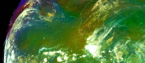
BESIDES THE ACTIVITY ASSOCIATED WITH THE SPECIAL
FEATURES/TROPICAL WAVES...SCATTERED MODERATE TO ISOLATED STRONG CONVECTION IS JUST OFFSHORE THE COAST OF AFRICA FROM 4N-9N BETWEEN 12W-22W. THIS ACTIVITY MAY BE ASSOCIATED WITH THE NEXT TROPICAL WAVE. THE STRONGER CLUSTER THAT MOVED OFF THE COAST OF SENEGAL LAST NIGHT HAS DIMINISHED A BIT...THOUGH SCATTERED MODERATE REMAINS FROM 13N-15N BETWEEN 19W-21W
.
:D :wink: we will see what happen, we have plenty of time fort that 8-)
0 likes   

User avatar
KWT
Category 5
Category 5
Posts: 31415
Joined: Tue Aug 17, 2004 11:02 am
Location: UK!!!

#2 Postby KWT » Mon Sep 24, 2007 11:39 am

Look how far north this one is though, this one will almost certainly be a fish unless it dives way south. Still will be another system to watch amongst many others.
0 likes   

User avatar
Gustywind
Category 5
Category 5
Posts: 12334
Joined: Mon Sep 03, 2007 7:29 am
Location: Baie-Mahault, GUADELOUPE

Re:

#3 Postby Gustywind » Mon Sep 24, 2007 1:59 pm

KWT wrote:Look how far north this one is though, this one will almost certainly be a fish unless it dives way south. Still will be another system to watch amongst many others.


To early to speculate in my humble opinion... fish or not.. :spam:
it's something to watch in the next couple days :D
0 likes   

User avatar
punkyg
Category 2
Category 2
Posts: 770
Joined: Mon Apr 23, 2007 7:37 pm
Location: sanford florida

#4 Postby punkyg » Mon Sep 24, 2007 2:47 pm

Image
Like is this the thread about the latest wave that moved off of africa?
cause if it is lets get to watching this. behind 96L
0 likes   

User avatar
canegrl04
Category 5
Category 5
Posts: 2486
Joined: Thu Aug 26, 2004 5:37 pm
Location: Texas

Re: Next Future Wave Exiting Africa

#5 Postby canegrl04 » Mon Sep 24, 2007 3:41 pm

All aboard the Cape Verde train :eek:
0 likes   

User avatar
Gustywind
Category 5
Category 5
Posts: 12334
Joined: Mon Sep 03, 2007 7:29 am
Location: Baie-Mahault, GUADELOUPE

#6 Postby Gustywind » Mon Sep 24, 2007 5:07 pm

Yeah since 96L i've noticed a suspicious train of waves well concentrated and souther than the previous month, something to watch !
0 likes   

User avatar
punkyg
Category 2
Category 2
Posts: 770
Joined: Mon Apr 23, 2007 7:37 pm
Location: sanford florida

#7 Postby punkyg » Tue Sep 25, 2007 6:27 am

Image
It may not look as good as yesterday, but atleast it still has convection. :D :)
0 likes   

User avatar
Gustywind
Category 5
Category 5
Posts: 12334
Joined: Mon Sep 03, 2007 7:29 am
Location: Baie-Mahault, GUADELOUPE

Re:

#8 Postby Gustywind » Tue Sep 25, 2007 6:56 am

punkyg wrote:Image
It may not look as good as yesterday, but atleast it still has convection. :D :)

FEATURES/TROPICAL WAVES...SCATTERED MODERATE CONVECTION IS ALONG
AND JUST OFF THE COAST OF AFRICA FROM 6N-13N BETWEEN 12W-18W.
SCATTERED MODERATE/ISOLATED STRONG IS WITHIN 150NM EITHER SIDE
OF THE AXIS BETWEEN 18W-27W. correct punkg convection :D

Absolutely punkg , the activity has weaken diminished a bit but always persistent...whereas nice activity can be observed on Africa....and if you look carefully further east... there's potential to see another waves south in comparison to what my untrained eyes have seen in August or Mid September :cheesy: .
Note that a professionnal forecaster at Meteo France this morning emphasizes on this tendency... to see more waves and probably developping?! :?: to early to tell...but seems that activity will occur in October... :eek: 8-) :darrow:
http://cimss.ssec.wisc.edu/tropic/real- ... et7bbm.jpg
http://www.nrlmry.navy.mil/sat-bin/disp ... C_SCALE=15
0 likes   

User avatar
punkyg
Category 2
Category 2
Posts: 770
Joined: Mon Apr 23, 2007 7:37 pm
Location: sanford florida

#9 Postby punkyg » Tue Sep 25, 2007 7:50 am

This wave looks below 10n am i right.


oh also the reason why these waves are moving off the coast at a lower latitude is, because these waves are stealing clothes from the equator so they won't be nude like the other waves. :lol: :lol: :cheesy: :ggreen: :lol: :D
0 likes   

User avatar
punkyg
Category 2
Category 2
Posts: 770
Joined: Mon Apr 23, 2007 7:37 pm
Location: sanford florida

#10 Postby punkyg » Tue Sep 25, 2007 2:53 pm

Image
Well this wave has more convection then earlier today.
do you think its getting ready to pull off a karen?
0 likes   

User avatar
Gustywind
Category 5
Category 5
Posts: 12334
Joined: Mon Sep 03, 2007 7:29 am
Location: Baie-Mahault, GUADELOUPE

Re:

#11 Postby Gustywind » Tue Sep 25, 2007 3:32 pm

punkyg wrote:Image
Well this wave has more convection then earlier today.
do you think its getting ready to pull off a karen?


Yeah more convection, no i doubt Karen is much stronger than this area of convection, something to watch for sure!
0 likes   

americanrebel

#12 Postby americanrebel » Tue Sep 25, 2007 3:45 pm

What is the likely hood of huge Karen sucking up this wave and just making herself even a little more dangerous and unpredictable.
0 likes   

User avatar
KWT
Category 5
Category 5
Posts: 31415
Joined: Tue Aug 17, 2004 11:02 am
Location: UK!!!

#13 Postby KWT » Tue Sep 25, 2007 3:51 pm

I wonder if we could see some Fujiwhara interaction if that wave behind it also forms. Its a little far away right now but if they get closer and this wave can develop enough you never know.
0 likes   

RL3AO
Moderator-Pro Met
Moderator-Pro Met
Posts: 16308
Joined: Thu Jun 14, 2007 10:03 pm
Location: NC

Re:

#14 Postby RL3AO » Tue Sep 25, 2007 3:57 pm

KWT wrote:I wonder if we could see some Fujiwhara interaction if that wave behind it also forms. Its a little far away right now but if they get closer and this wave can develop enough you never know.


Cane on cane action? :D
0 likes   

User avatar
punkyg
Category 2
Category 2
Posts: 770
Joined: Mon Apr 23, 2007 7:37 pm
Location: sanford florida

#15 Postby punkyg » Tue Sep 25, 2007 7:46 pm

Image
Convection increasing could this be the start of something?!?!
doubt it :D well keep on watching this baby.
0 likes   

User avatar
HURAKAN
Professional-Met
Professional-Met
Posts: 46086
Age: 38
Joined: Thu May 20, 2004 4:34 pm
Location: Key West, FL
Contact:

#16 Postby HURAKAN » Tue Sep 25, 2007 7:51 pm

I looks good and we need to keep an eye on it. The season is not dead, just that most of the activity came in September!!!

Like normal!!
0 likes   

User avatar
HURAKAN
Professional-Met
Professional-Met
Posts: 46086
Age: 38
Joined: Thu May 20, 2004 4:34 pm
Location: Key West, FL
Contact:

#17 Postby HURAKAN » Tue Sep 25, 2007 8:03 pm

Image

As south as pre-Karen once was.
0 likes   

User avatar
punkyg
Category 2
Category 2
Posts: 770
Joined: Mon Apr 23, 2007 7:37 pm
Location: sanford florida

#18 Postby punkyg » Tue Sep 25, 2007 8:05 pm

Image
Did pre-karen look like this or did it look better.
0 likes   

User avatar
HURAKAN
Professional-Met
Professional-Met
Posts: 46086
Age: 38
Joined: Thu May 20, 2004 4:34 pm
Location: Key West, FL
Contact:

Re:

#19 Postby HURAKAN » Tue Sep 25, 2007 8:17 pm

punkyg wrote:Image
Did pre-karen look like this or did it look better.


It looked better organized. Nevertheless, the intensity of the convection is impressive.
0 likes   

User avatar
Gustywind
Category 5
Category 5
Posts: 12334
Joined: Mon Sep 03, 2007 7:29 am
Location: Baie-Mahault, GUADELOUPE

Re: Re:

#20 Postby Gustywind » Tue Sep 25, 2007 8:24 pm

HURAKAN wrote:
punkyg wrote:Image
Did pre-karen look like this or did it look better.


It looked better organized. Nevertheless, the intensity of the convection is impressive.


Did you read my new thread" Newly Wave at 19w"? I put a new thread on that maybe we can merge it or wait a little.... :D
0 likes   


Return to “Talkin' Tropics”

Who is online

Users browsing this forum: caneman, Cpv17, riapal and 32 guests