

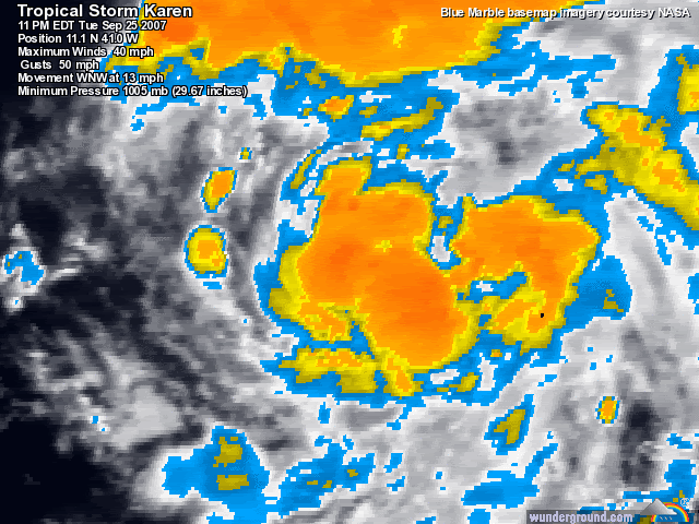
Dang! Karen what diet plan have you been using?
she is looking great right now do you think she'll strengthin by 11am?
Ex Tropical Depression KAREN: Discussions & Images
Moderator: S2k Moderators
-
HURAKAN

- Professional-Met

- Posts: 46084
- Age: 39
- Joined: Thu May 20, 2004 4:34 pm
- Location: Key West, FL
- Contact:
Re:
punkyg wrote:Dang! Karen what diet plan have you been using?
she is looking great right now do you think she'll strengthin by 11am?
Oh yeah!!! She already looks stronger than 50 mph.
If you want to get surprised even more : http://rammb.cira.colostate.edu/ramsdis ... is_floater
0 likes


Re: Tropical Storm KAREN: CEN ATL: Discussions & Images
remember Iris and Humberto from 1995. Iris was heading WNW and humberton became a hurricane behind her and she turned SW. If the low behind develops fast enough it could have a similar effect.
0 likes

-
Derek Ortt
-
Gustywind

- Category 5

- Posts: 12334
- Joined: Mon Sep 03, 2007 7:29 am
- Location: Baie-Mahault, GUADELOUPE
Re:
punkyg wrote:How bad is the shear to the north and to the west of karen?
http://cimss.ssec.wisc.edu/tropic/real- ... g8shr.html : decreasing to it west and 20kts or below 15k to its north
0 likes


-
Evil Jeremy

- S2K Supporter

- Posts: 5463
- Age: 32
- Joined: Mon Apr 10, 2006 2:10 pm
- Location: Los Angeles, CA
Re: Tropical Storm KAREN: CEN ATL: Discussions & Images
06z GFDL a west runner with the UKMET 
0 likes
-
Evil Jeremy
- S2K Supporter
- Posts: 5463
- Age: 32
- Joined: Mon Apr 10, 2006 2:10 pm
- Location: Los Angeles, CA
Re: Tropical Storm KAREN: Central ATL: Global & BAM Models
06z GFDL a west runner with the UKMET
0 likes

Trends
Generally I prefer the UKMET and ECMWF for tracking purposes. Both have solutions favoring a westward movement later in the period...
Euro actually has it moving wsw/sw late beyond 5 days. Here's the loop
http://www.ecmwf.int/products/forecasts ... 600!!step/
Generally I prefer the UKMET and ECMWF for tracking purposes. Both have solutions favoring a westward movement later in the period...
Euro actually has it moving wsw/sw late beyond 5 days. Here's the loop
http://www.ecmwf.int/products/forecasts ... 600!!step/
0 likes
-
Gustywind
- Category 5
- Posts: 12334
- Joined: Mon Sep 03, 2007 7:29 am
- Location: Baie-Mahault, GUADELOUPE
Re: Tropical Storm KAREN: Central ATL: Global & BAM Models
Evil Jeremy wrote:06z GFDL a west runner with the UKMET
 but who knows?
0 likes
Re:
Vortex wrote:Trends
Generally I prefer the UKMET and ECMWF for tracking purposes. Both have solutions favoring a westward movement later in the period...
Euro actually has it moving wsw/sw late beyond 5 days. Here's the loop
http://www.ecmwf.int/products/forecasts ... 600!!step/
Oh wow if i showed mom this she'd freak!
0 likes
-
Category 5

- Category 5
- Posts: 10074
- Age: 36
- Joined: Sun Feb 11, 2007 10:00 pm
- Location: New Brunswick, NJ
- Contact:
Re: Tropical Storm KAREN: Central ATL: Global & BAM Models
It's still way too early to predict whether this is going to be a fish or not.
0 likes
Who is online
Users browsing this forum: No registered users and 19 guests