Tropical Depression LORENZO: Discussions & Images
Moderator: S2k Moderators
Re:
CrazyC83 wrote:If upgraded at the 7 pm advisory, would this be the fastest ever a storm went from TD to hurricane?
Probably operationally, but it will be changed in the best track.
Also, I find it funny that the Spanish advisory is up to date on Karen, but there are none for Lorenzo.
0 likes

Re: Re:
RL3AO wrote:CrazyC83 wrote:If upgraded at the 7 pm advisory, would this be the fastest ever a storm went from TD to hurricane?
Probably operationally, but it will be changed in the best track.
Also, I find it funny that the Spanish advisory is up to date on Karen, but there are none for Lorenzo.
I wish I could find it funny as well.
I don't mean to rip the NHC on this, but looking at the storm at 11 AM it looked like a TS to me. Dvorak has been wrong before and this should have been one of those cases where radar was used and given the presentation and how it was going to continue to strengthen an upgrade would have been prudent at 11 AM. It looks bad for them to have to upgrade from a TD to a 60 mph TS at 2 PM ET because they relied on computer estimates and waited for the recon.
0 likes
-
HurricaneRobert
- Category 3

- Posts: 812
- Joined: Fri May 18, 2007 9:31 pm
Re:
PhillyWX wrote:This reminds me a bit like Stan, only farther north.
This is like another one from that season - Jose.
0 likes
-
HURAKAN

- Professional-Met

- Posts: 46084
- Age: 39
- Joined: Thu May 20, 2004 4:34 pm
- Location: Key West, FL
- Contact:
Re: Tropical Storm LORENZO: BOC : Discussions & Images
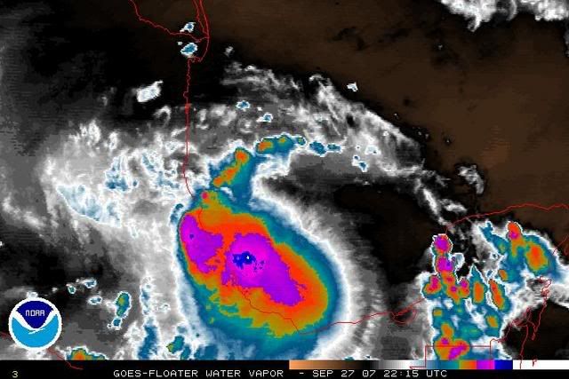
Look at the white spot in the center, very intense convection.
0 likes
Re: Re:
HurricaneRobert wrote:PhillyWX wrote:This reminds me a bit like Stan, only farther north.
This is like another one from that season - Jose.
Or Bret or Gert. There were a few in 2005 that blew up and moved inland.
0 likes

-
HurricaneRobert
- Category 3
- Posts: 812
- Joined: Fri May 18, 2007 9:31 pm
Re: Tropical Storm LORENZO: BOC : Discussions & Images
Stan took a while to develop. Wasn't it able to pull moisture in from the Pacific, soaking Guatemala completely? Lorenza has a lot of power, but not the abilities of that storm.
0 likes


Re: Tropical Storm LORENZO: BOC : Discussions & Images
I honestly hope the people there are ready for this storm. Theres a radar image at this site. http://johnzap.com/WEATHERveracruz.html
If you are so inclined, pray for the people there. This could be a nasty flood event.
If you are so inclined, pray for the people there. This could be a nasty flood event.
0 likes
-
Matt-hurricanewatcher
-
wxman57

- Moderator-Pro Met

- Posts: 23172
- Age: 68
- Joined: Sat Jun 21, 2003 8:06 pm
- Location: Houston, TX (southwest)
Re:
CrazyC83 wrote:If upgraded at the 7 pm advisory, would this be the fastest ever a storm went from TD to hurricane?
Don't forget Humberto. 15Z it was a TD, at 05Z (16 hrs hater) it was a hurricane. However, it was likely a TD at least 12 hours before then, but the NHC didn't upgrade it. And Lorenzo was almost certainly a TS this morning, but the plane had left when it intensified.
0 likes
-
CrazyC83
- Professional-Met
- Posts: 34315
- Joined: Tue Mar 07, 2006 11:57 pm
- Location: Deep South, for the first time!
Re: Re:
wxman57 wrote:CrazyC83 wrote:If upgraded at the 7 pm advisory, would this be the fastest ever a storm went from TD to hurricane?
Don't forget Humberto. 15Z it was a TD, at 05Z (16 hrs hater) it was a hurricane. However, it was likely a TD at least 12 hours before then, but the NHC didn't upgrade it. And Lorenzo was almost certainly a TS this morning, but the plane had left when it intensified.
Yep, even if we assumed it became a TS right after the 7 am advisory (at that point definitely a TD), it would be only a 12 hour race through tropical storm classification...
0 likes
-
whereverwx
- Category 5

- Posts: 1107
- Joined: Mon May 31, 2004 10:15 pm


-
CrazyC83
- Professional-Met
- Posts: 34315
- Joined: Tue Mar 07, 2006 11:57 pm
- Location: Deep South, for the first time!
Re: Re:
cycloneye wrote:CrazyC83 wrote:When is the next Recon flight? Late this evening?
A. 28/0600Z
B. AFXXX 0613A CYCLONE
C. 28/0230Z
D. 20.1N 96.7W
E. 28/0500Z TO 28/0900Z
F. SFC TO 10,000 FT
Just as I thought: 9:30 pm CDT.
0 likes
Who is online
Users browsing this forum: No registered users and 65 guests