Ex Tropical Depression KAREN: Discussions & Images

Moderator: S2k Moderators

Message
Author
User avatar
hial2
S2K Supporter
S2K Supporter
Posts: 809
Joined: Fri Oct 10, 2003 9:20 pm
Location: Indian trail N.C.

Re: Tropical Storm KAREN: CEN ATL: Discussions & Images

#1141 Postby hial2 » Thu Sep 27, 2007 6:08 pm

jaxfladude wrote:
Tampa Bay Hurricane wrote:
bwhorton2007 wrote:Is there any chance of karen rebounding into something nasty ?


After the shear subsides in 2 days or so...Euro rebounds it and explodes it to a
cat 3/4.

To whom or how close to whom are you speaking of????

Tropical Storm Karen(2007) please go the way Ingrid did, thank you, signed by everyone but people I disagree with...


My 3 cents: Miami/West Palm area first,crossing over to the Gulf to Texas via Naples,getting caught by an incoming front and heading east thru Ms and La,back to Florida over Tampa exiting Florida over Jax and heading north to NC where it will break the horrible draught with 2-3 ft of rain water..Oh,and never weaker than a cat2

My apologies to those I omitted.... :lol:
0 likes   

User avatar
punkyg
Category 2
Category 2
Posts: 770
Joined: Mon Apr 23, 2007 7:37 pm
Location: sanford florida

Re:

#1142 Postby punkyg » Thu Sep 27, 2007 6:13 pm

bwhorton2007 wrote:punky,
she should be in fairly high shear right now but with convection explosion over the center i just don't know. :eek:

So your saying was that the shear was only around for earlier today and that she'll do better tonight then last night.
:eek: :D wow i never use them googled eyed smilies :D
0 likes   

HurricaneRobert
Category 3
Category 3
Posts: 812
Joined: Fri May 18, 2007 9:31 pm

Re: Tropical Storm KAREN: CEN ATL: Discussions & Images

#1143 Postby HurricaneRobert » Thu Sep 27, 2007 6:25 pm

hial2 wrote:My 3 cents: Miami/West Palm area first,crossing over to the Gulf to Texas via Naples,getting caught by an incoming front and heading east thru Ms and La,back to Florida over Tampa exiting Florida over Jax and heading north to NC where it will break the horrible draught with 2-3 ft of rain water..Oh,and never weaker than a cat2

My apologies to those I omitted.... :lol:


Maybe it will get bigger. (Picture this on the other coast:

Image :lol:
0 likes   

User avatar
Category 5
Category 5
Category 5
Posts: 10074
Age: 35
Joined: Sun Feb 11, 2007 10:00 pm
Location: New Brunswick, NJ
Contact:

Re: Tropical Storm KAREN: CEN ATL: Discussions & Images

#1144 Postby Category 5 » Thu Sep 27, 2007 6:27 pm

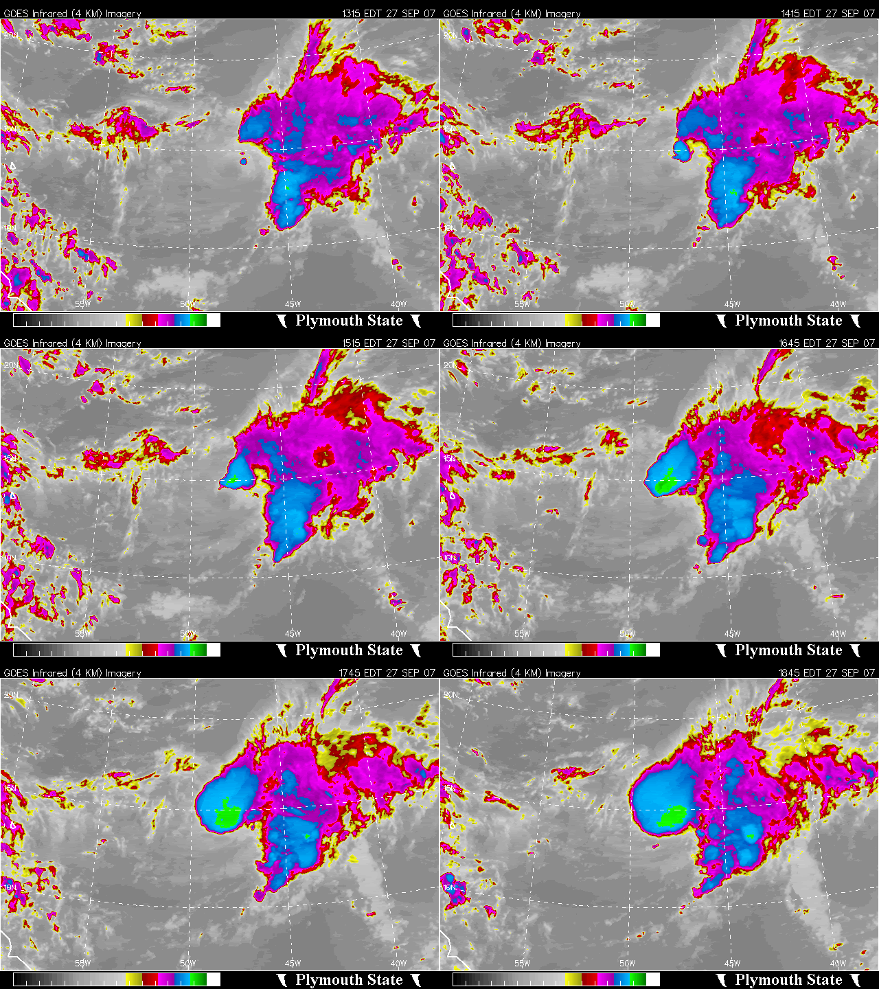
What a blowup, Not bad for a sheered system eh.

Image
0 likes   

bwhorton2007
Tropical Storm
Tropical Storm
Posts: 115
Joined: Thu Sep 13, 2007 11:17 pm

Re: Tropical Storm KAREN: CEN ATL: Discussions & Images

#1145 Postby bwhorton2007 » Thu Sep 27, 2007 6:29 pm

look at the upper level clouds they are screaming over her but convection is still building
over the center as of now i really don't have an explanation except that the trough in the area was weaker than expected and as a result shear maybe easing earlier than forecast.that's all i can come up with at the moment.
0 likes   

User avatar
ronjon
Category 5
Category 5
Posts: 4822
Joined: Fri Aug 19, 2005 5:17 pm
Location: Hernando Beach, FL

Re: Tropical Storm KAREN: : Global & BAM Models

#1146 Postby ronjon » Thu Sep 27, 2007 6:36 pm

Yes, the ridge is strong and the models are responding to an ever increasing bad synoptic setup. The only difference between the 12Z Euro and the 18Z GFS is that the Euro is about 12-24 hrs faster and the GFS has a strong cold front barrelling toward the east coast that deflects Karen away from S FL at the last minute. However, when I looked at the 12Z Euro 500 mb pattern it had no such front, and in fact, had high pressure firmly entrenched along the east coast with a sharp trough off the US west coast at 10 days out. We all know how weather patterns can change, especially 7-10 days out, so we'll have to see if we get some model consistency over the next few days on Karen's future track.
0 likes   

bwhorton2007
Tropical Storm
Tropical Storm
Posts: 115
Joined: Thu Sep 13, 2007 11:17 pm

#1147 Postby bwhorton2007 » Thu Sep 27, 2007 6:37 pm

Also though large in size she isn't a monster in the upper atmosphere right now and that may be allowing her to slide under the worst of the shear also.
0 likes   

Derek Ortt

Re: Tropical Storm KAREN: CEN ATL: Discussions & Images

#1148 Postby Derek Ortt » Thu Sep 27, 2007 6:41 pm

this convection will die by morning

In this type of environment, the convection usually builds and dies within a 12 hour period then repeats
0 likes   

User avatar
Ivanhater
Storm2k Moderator
Storm2k Moderator
Posts: 11161
Age: 38
Joined: Fri Jul 01, 2005 8:25 am
Location: Pensacola

Re: Tropical Storm KAREN: : Global & BAM Models

#1149 Postby Ivanhater » Thu Sep 27, 2007 6:43 pm

Image
0 likes   

User avatar
cycloneye
Admin
Admin
Posts: 145306
Age: 68
Joined: Thu Oct 10, 2002 10:54 am
Location: San Juan, Puerto Rico

Re: Tropical Storm KAREN: : Global & BAM Models

#1150 Postby cycloneye » Thu Sep 27, 2007 6:45 pm

866
WHXX04 KWBC 272330
CHGQLM
ATTENTION...NATIONAL HURRICANE CENTER

NCEP COUPLED GFDL HURRICANE MODEL FORECAST MADE FOR

TROPICAL STORM KAREN 12L

INITIAL TIME 18Z SEP 27

DISCLAIMER ... THIS INFORMATION IS PROVIDED AS GUIDANCE. IT
REQUIRES INTERPRETATION BY HURRICANE SPECIALISTS AND SHOULD
NOT BE CONSIDERED AS A FINAL PRODUCT. PLEASE SEE THE TPC/NHC
OFFICIAL FORECAST.


FORECAST STORM POSITION

HOUR LATITUDE LONGITUDE HEADING/SPEED(KT)

0 14.1 48.0 295./12.0
6 14.5 48.8 294./ 9.3
12 14.8 49.8 288./ 9.7
18 15.5 50.8 307./12.1
24 16.3 51.4 321./ 9.5
30 16.5 51.9 295./ 5.7
36 16.8 52.2 313./ 4.3
42 17.4 53.4 297./12.7
48 17.8 53.7 320./ 5.1
54 18.2 54.2 313./ 6.3
60 18.3 54.4 285./ 2.2
66 18.9 55.1 311./ 8.9
72 19.7 55.7 321./ 9.8
78 20.4 55.6 11./ 7.0
84 21.1 56.0 332./ 7.9
90 21.5 56.6 304./ 7.0
96 22.2 57.0 326./ 7.7
102 22.7 57.6 313./ 7.4
108 23.0 58.4 294./ 8.1
114 23.1 59.2 275./ 7.3
120 23.2 59.7 275./ 5.1
126 23.1 60.3 261./ 5.7

The 18z GFDL
0 likes   

User avatar
Emmett_Brown
Category 5
Category 5
Posts: 1432
Joined: Wed Aug 24, 2005 9:10 pm
Location: Sarasota FL

Re: Tropical Storm KAREN: CEN ATL: Discussions & Images

#1151 Postby Emmett_Brown » Thu Sep 27, 2007 6:46 pm

True... this will likely pulse, then get sheared again. I think these pulses will hold Karen together in a steady state for the next couple of days. Should keep it from being an Ingrid unless shear gets worse.

Those West trending models sure are interesting...
0 likes   

User avatar
ronjon
Category 5
Category 5
Posts: 4822
Joined: Fri Aug 19, 2005 5:17 pm
Location: Hernando Beach, FL

Re: Tropical Storm KAREN: : Global & BAM Models

#1152 Postby ronjon » Thu Sep 27, 2007 6:50 pm

Image
0 likes   

bwhorton2007
Tropical Storm
Tropical Storm
Posts: 115
Joined: Thu Sep 13, 2007 11:17 pm

#1153 Postby bwhorton2007 » Thu Sep 27, 2007 6:51 pm

also look at the noaa floater of the entire tropical atlantic
looks like karen is moving due west at the moment.
0 likes   

User avatar
Emmett_Brown
Category 5
Category 5
Posts: 1432
Joined: Wed Aug 24, 2005 9:10 pm
Location: Sarasota FL

Re: Tropical Storm KAREN: CEN ATL: Discussions & Images

#1154 Postby Emmett_Brown » Thu Sep 27, 2007 6:53 pm

This upper air pattern still looks pretty unfavorable. Yup, this pulse could be short lived.

http://www.ssd.noaa.gov/goes/east/catl/loop-wv.html
0 likes   

curtadams
S2K Supporter
S2K Supporter
Posts: 1122
Joined: Sun Aug 28, 2005 7:57 pm
Location: Orange, California
Contact:

Re: Tropical Storm KAREN: CEN ATL: Discussions & Images

#1155 Postby curtadams » Thu Sep 27, 2007 6:55 pm

From the way the coldest cloudtops jerked east it looks like the westerly shear finally took. I suspect the MLC was separated from the LLC by that and that convection will fade now. We'll see over the next few hours.

Very hard to determine motion now that the LLC is under the CDO. You can't separate motion from shear changes with just a geosync satellite shot.
0 likes   

User avatar
ronjon
Category 5
Category 5
Posts: 4822
Joined: Fri Aug 19, 2005 5:17 pm
Location: Hernando Beach, FL

Re: Tropical Storm KAREN: CEN ATL: Discussions & Images

#1156 Postby ronjon » Thu Sep 27, 2007 6:57 pm

0 likes   

User avatar
Category 5
Category 5
Category 5
Posts: 10074
Age: 35
Joined: Sun Feb 11, 2007 10:00 pm
Location: New Brunswick, NJ
Contact:

Re: Tropical Storm KAREN: CEN ATL: Discussions & Images

#1157 Postby Category 5 » Thu Sep 27, 2007 7:01 pm


We shouldn't be comparing it to Devestating past hurricanes yet. :wink:
0 likes   

User avatar
cycloneye
Admin
Admin
Posts: 145306
Age: 68
Joined: Thu Oct 10, 2002 10:54 am
Location: San Juan, Puerto Rico

Re: Tropical Storm KAREN: CEN ATL: Discussions & Images

#1158 Postby cycloneye » Thu Sep 27, 2007 7:17 pm

27/2345 UTC 14.0N 48.9W T2.5/2.5 KAREN -- Atlantic Ocean

http://www.ssd.noaa.gov/PS/TROP/positions.html
0 likes   

Matt-hurricanewatcher

Re: Tropical Storm KAREN: CEN ATL: Discussions & Images

#1159 Postby Matt-hurricanewatcher » Thu Sep 27, 2007 7:22 pm

http://www.nrlmry.navy.mil/tc_pages/tc0 ... atest.html


The navy shows that it was a hurricane yesterday. Why do they do that?
0 likes   

CrazyC83
Professional-Met
Professional-Met
Posts: 34002
Joined: Tue Mar 07, 2006 11:57 pm
Location: Deep South, for the first time!

Re: Tropical Storm KAREN: CEN ATL: Discussions & Images

#1160 Postby CrazyC83 » Thu Sep 27, 2007 7:26 pm

Matt-hurricanewatcher wrote:http://www.nrlmry.navy.mil/tc_pages/tc07/ATL/12L.KAREN/ssmi/gif/full/Latest.html


The navy shows that it was a hurricane yesterday. Why do they do that?


That was because the models initiated at 65 kt (even though the NHC did not recognize that in advisories). Officially it would still go down as Tropical Storm Karen (at least operationally).
0 likes   


Return to “2007”

Who is online

Users browsing this forum: No registered users and 10 guests