Tropical Depression LORENZO: Discussions & Images
Moderator: S2k Moderators
-
americanrebel
Re: Hurricane LORENZO: BOC : Discussions & Images
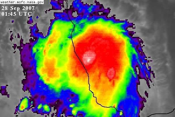
Over my head wrote:MiamiensisWx wrote:We may come close to a distinct eye. There are some signs (on IR) of a warm depression attempting to form near the convective "towers" in the CDO's center. I think it's safe to utilize "rapid intensification" here. I think frictional effects will prevent intensification beyond Category 2 status, but the excellent ventilation (via UL anticyclone and 5 kts of shear) + heat content = deepening trend until landfall.
Last GOES visible imagery before night
I just looked at this animation and it shows it growing bigger in each frame... but I see no spin. Why does this one not have the same spinning look that the others in the past few weeks have
had ?
If a visible were available you would see some spin of the low clouds...you are seeing the expanding tops of thunderstorms on the IR images...there is rotation below just not very visible without the visible images.
0 likes
Re: Hurricane LORENZO: BOC : Discussions & Images
jeff wrote:Over my head wrote:MiamiensisWx wrote:We may come close to a distinct eye. There are some signs (on IR) of a warm depression attempting to form near the convective "towers" in the CDO's center. I think it's safe to utilize "rapid intensification" here. I think frictional effects will prevent intensification beyond Category 2 status, but the excellent ventilation (via UL anticyclone and 5 kts of shear) + heat content = deepening trend until landfall.
Last GOES visible imagery before night
I just looked at this animation and it shows it growing bigger in each frame... but I see no spin. Why does this one not have the same spinning look that the others in the past few weeks have
had ?
If a visible were available you would see some spin of the low clouds...you are seeing the expanding tops of thunderstorms on the IR images...there is rotation below just not very visible without the visible images.
Alvarda, MX radar clearly shows the "eye"...ir the low level circulation. I did not find a loop feature but if there were one you would see good rotation.
Getting very close to the coast now..maybe 40-50 miles offshore...still could intensify another 5-15mph before landfall given latest convective burst and slow forward motion.
0 likes


Re: Hurricane LORENZO: BOC : Discussions & Images
MiamiensisWx wrote:I have a question for the professionals and others on this excellent board. Can a developing outer band (associated with decent low-level convergence) signify the beginning of a RI event? On WV imagery, you can see the convective band developing NW of Lorenzo "in sync" with the storm's quick pre-landfall deepening trend. I have seen this trend with Charley and numerous other storms (especially compact systems) when a fast strengthening trend started to run its course.
http://www.ssd.noaa.gov/goes/flt/t4/loop-wv.html
By the way, props to those (amateur, professional, and others) who stated the possibility for intensification to a hurricane before MX landfall. Good job, wxman57 and others!
When I was watching Humberto, I noticed one MCV basically took over and became the hurricane itself. I suspect something similar happened with Lorenzo. Usually you have multiple MCVs competing and rotating around a common center in developing tropical depressions and storms, so something fundamentally different is occurring at the mesoscale, and I don't think the research community really understands it yet. We know hurricane eyewalls are quite frontogenic meaning that gradients in pressure/moist energy can become very large very quickly, but I can't immediately answer why small core systems have a tendency to respond so quickly sometimes (but not always!). One would think that the surface fluxes are confined over a smaller area and the opposite should actually occur. Anyway, interesting problem, and one that deserves further exploration.
0 likes
-
Matt-hurricanewatcher
Re: Hurricane LORENZO: BOC : Discussions & Images
Based on a clear and closed eye wall on a Mexican radar. I'm very impressed with this system, it may already be 85-90 knots if the radar sig has anything to say about it.
0 likes
-
CrazyC83
- Professional-Met

- Posts: 34315
- Joined: Tue Mar 07, 2006 11:57 pm
- Location: Deep South, for the first time!
Re: Hurricane LORENZO: BOC : Discussions & Images
Matt-hurricanewatcher wrote:Based on a clear and closed eye wall on a Mexican radar. I'm very impressed with this system, it may already be 85-90 knots if the radar sig has anything to say about it.
I'm not sure about that much, although it is hard to say due to lack of reliable data available. I'd estimate 70 kt right now, but I could be off some.
0 likes
-
americanrebel
-
Matt-hurricanewatcher
Re: Hurricane LORENZO: BOC : Discussions & Images
"if" its still going through the IRC my numbers may not be wrong. I can't wait intill the recon gets in there.
0 likes
-
Tampa Bay Hurricane

- Category 5

- Posts: 5597
- Age: 38
- Joined: Fri Jul 22, 2005 7:54 pm
- Location: St. Petersburg, FL
-
Matt-hurricanewatcher
Re:
americanrebel wrote:So you are saying there could be 2 Cat 2 instead of 2 Cat 1 in the post season analysis. Humberto and Lorenzo.
Its possible humberto could be upgraded to a 85 knot cat2 in post season. Based on the eyewall drop of 83 knots. In a few other things.
This we will have to see.
0 likes
-
CrazyC83
- Professional-Met
- Posts: 34315
- Joined: Tue Mar 07, 2006 11:57 pm
- Location: Deep South, for the first time!
Re: Re:
Matt-hurricanewatcher wrote:americanrebel wrote:So you are saying there could be 2 Cat 2 instead of 2 Cat 1 in the post season analysis. Humberto and Lorenzo.
Its possible humberto could be upgraded to a 85 knot cat2 in post season. Based on the eyewall drop of 83 knots. In a few other things.
This we will have to see.
Humberto had conflicting signals, although I think 80 kt was the correct landfall intensity personally, I wouldn't be totally shocked to see it upgraded to Cat 2.
The next Lorenzo mission should be exciting...(unless you are in the landfall area). At least they had some time to prepare as it strengthened in daylight, but the flooding could be really bad.
Last edited by CrazyC83 on Thu Sep 27, 2007 9:09 pm, edited 1 time in total.
0 likes
-
Tampa Bay Hurricane
- Category 5
- Posts: 5597
- Age: 38
- Joined: Fri Jul 22, 2005 7:54 pm
- Location: St. Petersburg, FL
-
lrak

- S2K Supporter

- Posts: 1770
- Age: 59
- Joined: Thu Jun 21, 2007 2:48 pm
- Location: Corpus Christi, TX
Re: Hurricane LORENZO: BOC : Discussions & Images
it looks to be taking a ride up the coast. No Lorenzo says...I want the grand tour before my demise 
0 likes
-
txwatcher91
- Category 5
- Posts: 1498
- Joined: Tue Aug 02, 2005 2:29 pm
-
HURAKAN

- Professional-Met
- Posts: 46084
- Age: 39
- Joined: Thu May 20, 2004 4:34 pm
- Location: Key West, FL
- Contact:
Re:
txwatcher91 wrote:When does recon get in Lorenzo?
FLIGHT TWO --TEAL 74
A. 28/0600Z
B. AFXXX 0613A CYCLONE
C. 28/0230Z
D. 20.1N 96.7W
E. 28/0500Z TO 28/0900Z
F. SFC TO 10,000 FT
2 AM EDT
0 likes
-
HURAKAN
- Professional-Met
- Posts: 46084
- Age: 39
- Joined: Thu May 20, 2004 4:34 pm
- Location: Key West, FL
- Contact:
Re: Hurricane LORENZO Recon obs
FLIGHT TWO --TEAL 74
A. 28/0600Z
B. AFXXX 0613A CYCLONE
C. 28/0230Z
D. 20.1N 96.7W
E. 28/0500Z TO 28/0900Z
F. SFC TO 10,000 FT
Plane leaves at 1030 PM EDT.
A. 28/0600Z
B. AFXXX 0613A CYCLONE
C. 28/0230Z
D. 20.1N 96.7W
E. 28/0500Z TO 28/0900Z
F. SFC TO 10,000 FT
Plane leaves at 1030 PM EDT.
0 likes
-
txwatcher91
- Category 5
- Posts: 1498
- Joined: Tue Aug 02, 2005 2:29 pm
Re: Re:
HURAKAN wrote:txwatcher91 wrote:When does recon get in Lorenzo?
FLIGHT TWO --TEAL 74
A. 28/0600Z
B. AFXXX 0613A CYCLONE
C. 28/0230Z
D. 20.1N 96.7W
E. 28/0500Z TO 28/0900Z
F. SFC TO 10,000 FT
2 AM EDT
Thanks. It looks like they will find an intensifying Cat 2.
0 likes
Who is online
Users browsing this forum: No registered users and 16 guests