
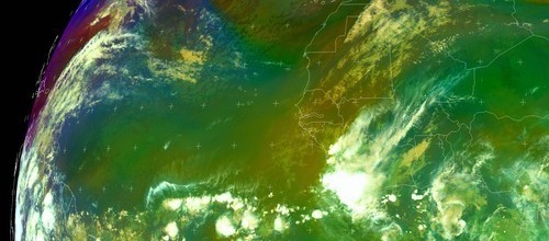
A few of the computer modles seem to want to develop the complex of showers(associated with a tropical wave) over the next couple of days as it traverses the Atlantic. It would be interesting to see how this pans out as conditions are expected to improve accross the basin with a stronger high pressure ridge expected to retrograde from the US coast to the Norther Atlantic.
http://www.ssd.noaa.gov/PS/TROP/DATA/RT/EATL/IR4/20.jpg
Wave in East Atlantic
Moderator: S2k Moderators
Forum rules

The posts in this forum are NOT official forecasts and should not be used as such. They are just the opinion of the poster and may or may not be backed by sound meteorological data. They are NOT endorsed by any professional institution or STORM2K. For official information, please refer to products from the National Hurricane Center and National Weather Service.
Wave in East Atlantic
0 likes

Re: Wave coming off African Coast
Dereck as the go man, what do you expect given the upper air paterns forcasted over the next 7 days.
0 likes
-
Derek Ortt
-
Matt-hurricanewatcher
Re: Wave coming off African Coast
This has about 48-60 hours before it runs into the super tutt. So maybe a chance for some development. As for TD 14 it will have to recurve with the shear to have any chance at a name. Derek do you agree or disagree?
0 likes

Re: Wave coming off African Coast
The next player is the system at 10N/18W, convection is on the increase.
0 likes


-
HurricaneMaster_PR

- Category 2

- Posts: 795
- Joined: Tue Jul 22, 2003 6:23 pm
- Location: San Juan, Puerto Rico
Re: Wave coming off African Coast
TWD 8:05pm
TROPICAL WAVE IS INTRODUCED ON THE 18Z ANALYSIS ALONG 18W S OF
14N ESTIMATED TO BE MOVING W 10-15 KT. THIS WAVE IS LOWER
AMPLITUDE THAT MANY OF PREVIOUS ONES THIS MONTH. THERE ARE
SEVERAL DATA SOURCES SUPPORTING THE EXISTENCE OF THIS NEW WAVE.
THE MIMIC TPW ANIMATION SHOWS A MODEST BULGE OF MOISTENED AIR
OFF THE AFRICAN COAST. SATELLITE IMAGERY AND DERIVED WINDS SHOW
A BROAD AREA OF TURNING WITH SCATTERED SHOWERS AND TSTMS
POSSIBLE WITHIN 180 NM OF THE AXIS. IN ADDITION...SOUNDING DATA
FROM DAKAR SHOWS THE 600-800 MB FLOW VEERING TO THE SE AND
ACCELERATING BEHIND THE WAVE.
0 likes
-
Gustywind

- Category 5

- Posts: 12334
- Joined: Mon Sep 03, 2007 7:29 am
- Location: Baie-Mahault, GUADELOUPE
000
AXNT20 KNHC 301044
TWDAT
TROPICAL WEATHER DISCUSSION
NWS TPC/NATIONAL HURRICANE CENTER MIAMI FL
805 AM EDT SUN SEP 30 2007
TROPICAL WEATHER DISCUSSION FOR NORTH AMERICA...CENTRAL
AMERICA...THE GULF OF MEXICO...THE CARIBBEAN SEA...NORTHERN
SECTIONS OF SOUTH AMERICA...AND THE ATLANTIC OCEAN TO THE
AFRICAN COAST FROM THE EQUATOR TO 32N. THE FOLLOWING INFORMATION
IS BASED ON SATELLITE IMAGERY...METEOROLOGICAL ANALYSIS...
WEATHER OBSERVATIONS...AND RADAR.
BASED ON 0600 UTC SURFACE ANALYSIS AND SATELLITE IMAGERY THROUGH
1015 UTC.
...TROPICAL WAVES...
TROPICAL WAVE IS OFF THE COAST OF W AFRICA ALONG 21W S OF 16N MOVING W 10-15 KT. THIS WAVE IS LOWER IN AMPLITUDE THAN MANY OF PREVIOUS WAVES THIS MONTH. THE MIMIC TPW ANIMATION SHOWS A MODEST BULGE OF MOISTENED AIR OFF THE AFRICAN COAST. SATELLITE IMAGERY AND DERIVED WINDS SHOW A BROAD AREA OF TURNING.
SCATTERED MODERATE TO ISOLATED STRONG CONVECTION IS W OF THE
WAVE AXIS FROM 2N-8N BETWEEN 24W-26W.
0 likes
-
Gustywind
- Category 5
- Posts: 12334
- Joined: Mon Sep 03, 2007 7:29 am
- Location: Baie-Mahault, GUADELOUPE
000
AXNT20 KNHC 010552
TWDAT
TROPICAL WEATHER DISCUSSION
NWS TPC/NATIONAL HURRICANE CENTER MIAMI FL
205 AM EDT MON OCT 01 2007
TROPICAL WEATHER DISCUSSION FOR NORTH AMERICA...CENTRAL
AMERICA...THE GULF OF MEXICO...THE CARIBBEAN SEA...NORTHERN
SECTIONS OF SOUTH AMERICA...AND THE ATLANTIC OCEAN TO THE
AFRICAN COAST FROM THE EQUATOR TO 32N. THE FOLLOWING INFORMATION
IS BASED ON SATELLITE IMAGERY...METEOROLOGICAL ANALYSIS...
WEATHER OBSERVATIONS...AND RADAR.
BASED ON 0000 UTC SURFACE ANALYSIS AND SATELLITE IMAGERY
THROUGH 0315 UTC.
...TROPICAL WAVES...
AN ATLANTIC OCEAN TROPICAL WAVE ALONG 25W/26W SOUTH OF 14N MOVING WEST 15 KT. STRONG SHOWERS AND
THUNDERSTORMS FROM 8N TO 9N BETWEEN 24W AND 25W. ISOLATED
MODERATE SHOWERS ELSEWHERE
FROM 7N TO 12N BETWEEN 23W AND 28W.
0 likes
-
Gustywind
- Category 5
- Posts: 12334
- Joined: Mon Sep 03, 2007 7:29 am
- Location: Baie-Mahault, GUADELOUPE
Re:
Cyclone1 wrote:It sure is late to have waves coming off of Africa. This year is really outta whack.
Yeah keep watching them in case of Mother has alaways surprises in store and thus this year...
0 likes
Who is online
Users browsing this forum: No registered users and 78 guests