EX INVEST 94L Thread
Moderator: S2k Moderators
Re: INVEST 94L Models Thread
If this develops which I think it will - look for it to linger in the western caribean for quite some time. Both 12Z NOGAPs, UKMET, and MM5 just keep the system drifting around in the western caribbean for 5-6 days. GFS 200 mb winds are forecast to be extremely light over the NW caribbean for the next 5 days so look for perhaps major intensification with this one. A trough will start to dig down from the northern gulf coast with strong shear in 6 days so if the system drifts north enough it may get picked up and carried rapidly east - all the elements would have to come together but will may be looking at another Wilma type situation for next weekend.
0 likes
- cycloneye
- Admin

- Posts: 149276
- Age: 69
- Joined: Thu Oct 10, 2002 10:54 am
- Location: San Juan, Puerto Rico
Re: INVEST 94L : Western Caribbean : Discussions & Images
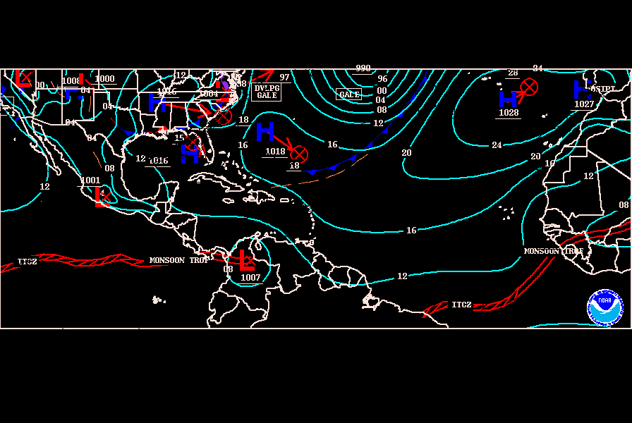
Here is the latest from TAFB about the low in W Caribbean.


0 likes
-
Derek Ortt
Re:
Derek Ortt wrote:that circulation near Cuba is what I am thinking is the developing UL
That is why I am not currently all that enthused with this storm.
Right now, I am more worried if Ryan Miller can make a save tonight than I am of a major Carib hurricane
There is also a surface feature moving into the Yucatan Channel....shear looks a bit bad for the SW Caribbean low, but it is firing some nice convection in and around the general vicinity.
0 likes
Re: INVEST 94L : Western Caribbean : Discussions & Images
If its gonna happen this is the exact location where many memorable storms have formed in October and affected the keys and florida. It will probablly meander for the next 2-3 days before beginning to lift NW then N followed by NE late in the week ahead of an advancing trough...
0 likes
- wzrgirl1
- S2K Supporter

- Posts: 1360
- Joined: Sat Sep 04, 2004 6:44 am
- Location: Pembroke Pines, Florida
Re: INVEST 94L : Western Caribbean : Discussions & Images
Vortex wrote:If its gonna happen this is the exact location where many memorable storms have formed in October and affected the keys and florida. It will probablly meander for the next 2-3 days before beginning to lift NW then N followed by NE late in the week ahead of an advancing trough...
Yes this is true....something to keep our eyes on....not sure if this will be the year of an October storm for Florida though....too much hostility out there
0 likes
- hurricanetrack
- HurricaneTrack.com

- Posts: 1781
- Joined: Tue Dec 02, 2003 10:46 pm
- Location: Wilmington, NC
- Contact:
Re: INVEST 94L Models Thread
Someone send me a telegram when this thing gets going. I will be in my cave.
0 likes
-
Brent
- S2K Supporter

- Posts: 38729
- Age: 37
- Joined: Sun May 16, 2004 10:30 pm
- Location: Tulsa Oklahoma
- Contact:
Re: INVEST 94L : Western Caribbean : Discussions & Images
I see a mess of disorganized convection and nothing developing anytime soon. After 92L turned out to be nothing I'm in the "believe it when I see it" category.
0 likes
Re: INVEST 94L : Western Caribbean : Discussions & Images
After Humberto,every invest has been a TS that fizzled,or system that never got off the ground.I can't remember I time when this happened.If this one becomes a named storm,I will finally wake up from the 2007 tropical duldrums
0 likes
- lrak
- S2K Supporter

- Posts: 1770
- Age: 59
- Joined: Thu Jun 21, 2007 2:48 pm
- Location: Corpus Christi, TX
Re: INVEST 94L : Western Caribbean : Discussions & Images
http://www.ndbc.noaa.gov/station_page.php?station=42056
this buoy is the one to watch for a W or SW wind if that circulation off the tip of Cuba gets any better organized.
this buoy is the one to watch for a W or SW wind if that circulation off the tip of Cuba gets any better organized.
0 likes
Re: INVEST 94L : Western Caribbean : Discussions & Images
I see a lot of invests. 94L looks like the closest problem for us. What is 90L is now over Texas.
0 likes
- lrak
- S2K Supporter

- Posts: 1770
- Age: 59
- Joined: Thu Jun 21, 2007 2:48 pm
- Location: Corpus Christi, TX
Re: INVEST 94L : Western Caribbean : Discussions & Images
ok the buoy just switched to WNW hmm.....
and a 29.69 pressure to boot.
http://weather.noaa.gov/weather/current/MMCP.html kind of far away but 12 WNW wind.
and a 29.69 pressure to boot.
http://weather.noaa.gov/weather/current/MMCP.html kind of far away but 12 WNW wind.
0 likes
Re: INVEST 94L : Western Caribbean : Discussions & Images
The NHC does say that pressures are falling in the area. I think this of the invests has the best chance to "make a name for itself"
0 likes
- cycloneye
- Admin

- Posts: 149276
- Age: 69
- Joined: Thu Oct 10, 2002 10:54 am
- Location: San Juan, Puerto Rico
Re: INVEST 94L : Western Caribbean : Discussions & Images
5:30 PM TWO:
SHOWER ACTIVITY OVER THE NORTHWESTERN CARIBBEAN SEA IS ASSOCIATED
WITH A BROAD AREA OF LOW PRESSURE CENTERED BETWEEN HONDURAS AND THE
CAYMAN ISLANDS. SURFACE PRESSURES ARE FALLING IN THE AREA...AND
FURTHER DEVELOPMENT OF THIS SYSTEM IS POSSIBLE OVER THE NEXT FEW
DAYS AS IT REMAINS NEARLY STATIONARY.
I concur with BigA ,this one is by far the best shot to get a name.
0 likes
-
MiamiensisWx
Re: INVEST 94L : Western Caribbean : Discussions & Images
Forget the other current areas, 92L, TD 10, '07 "trend", etc. - this is the first legitimate area (in recent weeks) that really should be monitored. It is situated in a climatologically favored region and regime. Low-level convergence is increasing per satellite imagery; we have been observing slowly falling sfc pressures; and we have a pre-existant sfc trough in the vicinity. Additionally, shear is marginal (not inhibitive), thus providing some nice UL diffluence. Check the recent GOES-E W Atlantic visible loop. There is some low-level 850 mb vorticity in the area. The biggest issue is northerly flow, but I believe the other conducive factors may override the situation. The operational GFS (~54 hours) builds a 588 dm UL ridge over the Gulf of Mexico, thus providing favorable UL easterlies. Additionally, there are light winds at 250 mb. There is a considerable amount of uncertainty with respect to the 500 mb progged pattern (future path), and 94L's close proximity to land indicates all areas should monitor the system.
0 likes
- wxman57
- Moderator-Pro Met

- Posts: 23172
- Age: 68
- Joined: Sat Jun 21, 2003 8:06 pm
- Location: Houston, TX (southwest)
Re: INVEST 94L : Western Caribbean : Discussions & Images
I go away for a day and 92L becomes 94L? It was moving across the Bahamas into Cuba when I left yesterday, and I pointed out the lowering pressure in the NW Caribbean. Why the need to call it a different invest? It's the same system, pushed into the Caribbean by NE winds around the high to the northwest of 92L.
Well, at least this one isn't fighting icebergs like 95L.
Well, at least this one isn't fighting icebergs like 95L.
0 likes
Re: INVEST 94L : Western Caribbean : Discussions & Images
Well the X-man 57 did it again!! He called it,almost to the hour...How does he do it? Could it be that he studied for many years,and probably still owes lots of money?? 
Kudos to you,sir
Kudos to you,sir
0 likes
- wxman57
- Moderator-Pro Met

- Posts: 23172
- Age: 68
- Joined: Sat Jun 21, 2003 8:06 pm
- Location: Houston, TX (southwest)
Re: INVEST 94L : Western Caribbean : Discussions & Images
hial2 wrote:Well the X-man 57 did it again!! He called it,almost to the hour...How does he do it? Could it be that he studied for many years,and probably still owes lots of money??
Kudos to you,sir
I'm not sure what you're talking about.

0 likes
- Evil Jeremy
- S2K Supporter

- Posts: 5463
- Age: 32
- Joined: Mon Apr 10, 2006 2:10 pm
- Location: Los Angeles, CA
Re: INVEST 94L : Western Caribbean : Discussions & Images
actually wxman, i think 92L disapated and reformed into 93L, and this came out of nowhere.
0 likes
Who is online
Users browsing this forum: No registered users and 81 guests


