Wow. What a nice morning it is out there!
6am temperatures around town..
Conroe - 61
Hooks - 64
IAH - 66
Hobby - 70
SE TX/SW LA weather: Much cooler and WET after Tuesday
Moderator: S2k Moderators
Forum rules

The posts in this forum are NOT official forecast and should not be used as such. They are just the opinion of the poster and may or may not be backed by sound meteorological data. They are NOT endorsed by any professional institution or STORM2K.
-
Extremeweatherguy

- Category 5

- Posts: 11095
- Joined: Mon Oct 10, 2005 8:13 pm
- Location: Florida
-
weatherrabbit_tx

- Category 1

- Posts: 270
- Joined: Wed Dec 21, 2005 3:13 pm
- Location: Kingwood,Tx
- Contact:
Re: SE TX/SW LA Discussion - Rain chances return..
we need some of those temps again real soon, it hasnt been quite that bad this morning
0 likes
-
Extremeweatherguy
- Category 5
- Posts: 11095
- Joined: Mon Oct 10, 2005 8:13 pm
- Location: Florida
Remember that early leaf change I mentioned earlier this month? Well it seems like it has continued and now there are quite a few trees in this area that are almost bare for the winter. This is really early to see this kind of thing take place and I am very perplexed as to why this is happening. Is anyone else noticing some "nearly bare" trees in their area? And does anyone have an answer as to why this could be taking place so early...especially since we have yet to see a strong front?
Here are some pictures I snapped today showing this early change in the trees:
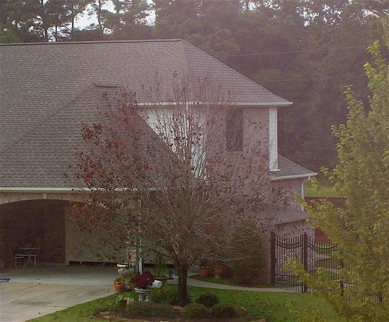
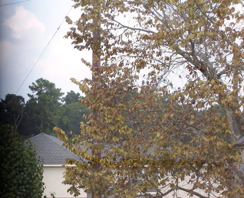
Here are some pictures I snapped today showing this early change in the trees:
0 likes
-
vbhoutex

- Storm2k Executive

- Posts: 29149
- Age: 74
- Joined: Wed Oct 09, 2002 11:31 pm
- Location: Cypress, TX
- Contact:
Re: SE TX/SW LA Discussion - warmer than normal temps. continue
Most of the "early change" in our area is due to the fact that we haven't had a decent rain in two weeks or more and it is the time of year when things do begin to go into their more "dormant" stages. I believe it is a combination of all of that as opposed to a harbinger of things to come. Of course as I sit here typing this it has now begun to pour rain at my house!!!LOLOLOL!!!! 
0 likes
-
jasons2k

- Storm2k Executive
- Posts: 8290
- Age: 52
- Joined: Wed Jul 06, 2005 12:32 pm
- Location: The Woodlands, TX
Re: SE TX/SW LA Discussion - warmer than normal temps. continue
This looks like the most interesting weather week in a long time:
- First rain today in WEEKS
- Possible last tropical threat of the season
- Possible first real front of the fall
- Potential for a serious rain event combining the two.
The AFD says it all:
- First rain today in WEEKS
- Possible last tropical threat of the season
- Possible first real front of the fall
- Potential for a serious rain event combining the two.
The AFD says it all:
AREA FORECAST DISCUSSION
NATIONAL WEATHER SERVICE HOUSTON/GALVESTON TX
333 AM CDT SUN SEP 30 2007
.DISCUSSION...
THINGS GET MORE INTERESTING TOWARD THE END OF THE WEEK. AN AREA OF
DISTURBED WEATHER WILL DEVELOP OVER THE EASTERN GULF AND MOVE
WEST. GLOBAL MODELS DIVERGE IN THEIR RESPECTIVE SOLUTIONS BUT
THERE SHOULD BE AN INCREASE IN MOISTURE BY FRIDAY WITH A GOOD
CHANCE OF RAIN ON SATURDAY. THE UPPER LOW WILL APPROACH TEXAS
COINCIDENT WITH AN APPROACHING UPPER LEVEL TROUGH. THE UPPER
TROUGH WILL PHASE WITH THE UPPER LOW AS IT PUSHES EAST. THIS
ALLOWS A COLD FRONT TO CROSS THE AREA. IF THE LONG RANGE MODELS
ARE CORRECT...THIS WILL BE THE FIRST SIGNIFICANT COLD FRONT OF THE
SEASON. THE GFS HAS TEASED US BEFORE WITH REGARD TO A COLD FRONTAL
PASSAGE BUT THERE IS SOME COLDER AIR BEGINNING TO BUILD IN CANADA
AND OTHER LONG RANGE MODELS SUPPORT THE GFS SOLUTION. WHETHER OR
NOT THE FRONT CROSSES THE AREA...THE POSITION OF THE UPPER LOW AND
TROPICAL MOISTURE SHOULD PRODUCE A GOOD CHANCE OF RAIN NEXT SAT
AND SUN. 43
0 likes
-
jasons2k
- Storm2k Executive
- Posts: 8290
- Age: 52
- Joined: Wed Jul 06, 2005 12:32 pm
- Location: The Woodlands, TX
Re: SE TX/SW LA Discussion - Watching tropics this week
From Jeff Lindner:
Area of disturbed weather over the SE Gulf of Mexico has been declared 90L.
Discussion:
Large TUTT low located WSW of Key West this morning with very weak surface low noted over the FL Keys…more of a surface trough than anything. The trough is undergoing strong SW wind shear on the E side of the TUTT low and at least for the next 24 hours little to no development is expected.
Track:
Global models are showing lots of spread this morning taking the system from the FL panhandle to the TX coast. The upper air steering pattern has a ridge of high pressure over the SE US which is forecast to remain through the weekend. The expected strong central US trough and cold front this weekend looks much weaker now with a maintaining of the SE US ridge. Hence a track of the TUTT and surface low toward the W or WNW is most likely for the next 2-3 days. This would place a surface feature in the NW Gulf of Mexico around Friday.
Intensity:
Not real concerned with intensity given the TUTT ahead of the surface feature producing shear. Pattern setup is very similar to TD 10 and massive amounts of dry air reside over the western and central Gulf of Mexico which will stunt thunderstorms development. None of the global guidance really develops the system and this appears reasonable given the proximity to the TUTT low and the forecasted shear values.
Impacts:
May need to raise rain chances significantly for the Friday through Sunday period should the system track toward TX. Tides are already running .5 to 1.0 feet above normal due to strong E flow across the N Gulf and these may be enhanced even more by late this week.
Other Item:
Advertised cold front for late this weekend looks to be a none event now as models have greatly backed off on frontal surge and eject the upper trough NE from CO toward the Great Lakes. SE US ridge should remain stout not allowing any frontal passage for SE TX. Will go ahead and stall front and cooler air mass well to our north over OK and N TX. Sorry, folks the wait for fall to arrive continues.
0 likes
-
PTrackerLA

- Category 5
- Posts: 5281
- Age: 42
- Joined: Thu Oct 10, 2002 8:40 pm
- Location: Lafayette, LA
-
Extremeweatherguy
- Category 5
- Posts: 11095
- Joined: Mon Oct 10, 2005 8:13 pm
- Location: Florida
Somewhat good news from the Houston morning AFD. It looks like Fall may finally arrive by next weekend...
A WEAK COLD FRONT STILL EXPECTED TO MOVE INTO SOUTHEAST TEXAS ON
TUESDAY. WHILE THE FRONT WILL EVENTUALLY MAKE IT TO THE COAST...THE
DRIER AIR WILL BE VERY SLOW TO WORK ITS WAY SOUTH INTO THE AREA.
HAVE MAINTAINED CHANCE POPS AREAWIDE TUESDAY WITH PWS STILL IN
1.7-2.0 INCH RANGE. BY WEDNESDAY...NRN ZONES DRY OUT BUT STILL
ENOUGH MOISTURE TO WARRANT LOW POPS FOR THE SE HALF OF THE AREA.
FINALLY...DRIER AIR REACHES THE COAST BY THURSDAY. KEPT FORECAST
PRECIP-FREE FROM THURSDAY ONWARD. GFS/ECMWF AND GFS ENSEMBLE
BEGINNING TO COME IN LINE WITH A PATTERN CHANGE BY NEXT WEEKEND
(MORE TROUGHING IN THE EAST...RIDGING SHIFTING TO DESERT SOUTHWEST).
THIS SHOULD RESULT IN A GRADUAL COOLING TREND FOR THE AREA. HAVE
STAYED CONSERVATIVE (WARM) WITH TEMP FORECAST BECAUSE...WELL...
WE`VE SEEN THIS BEFORE.
0 likes
-
Extremeweatherguy
- Category 5
- Posts: 11095
- Joined: Mon Oct 10, 2005 8:13 pm
- Location: Florida
-
Extremeweatherguy
- Category 5
- Posts: 11095
- Joined: Mon Oct 10, 2005 8:13 pm
- Location: Florida
Forecast now looks ever nicer this morning...
...looks like Fall may finally be arriving for real at the end of this week.
Wednesday Night: Partly cloudy, with a low around 67.
Thursday: Mostly sunny, with a high near 86.
Thursday Night: Mostly clear, with a low around 62.
Friday: Mostly sunny, with a high near 84.
Friday Night: Mostly clear, with a low around 60.
Saturday: Mostly sunny, with a high near 83.
...looks like Fall may finally be arriving for real at the end of this week.
0 likes
-
Yankeegirl

- Category 5
- Posts: 3417
- Age: 50
- Joined: Sun May 23, 2004 11:59 pm
- Location: Cy-Fair, Northwest Houston
- Contact:
-
CajunMama
- Retired Staff

- Posts: 10791
- Joined: Thu Feb 06, 2003 9:57 pm
- Location: 30.22N, 92.05W Lafayette, LA
Fun shopping trip to Walmart. Got stuck inside the store while waiting for it to end. I called BreinLa and she said it would be awhile before the rain stopped. After waiting for probably a total of 30 minutes for the rain to slack up i went back and bought an umbrella. Still got soaking wet! Ah well, a little water never hurt anyone. 
0 likes
-
vbhoutex
- Storm2k Executive
- Posts: 29149
- Age: 74
- Joined: Wed Oct 09, 2002 11:31 pm
- Location: Cypress, TX
- Contact:
Re:
Yankeegirl wrote:This sucks.... I wanted to go to the Wings Over Houston Airshow today but it has been raining or drizzling at my house all morning! What a bummer.... guess I will go shoppin!!!
Is the dome leaking?hehehe
0 likes
-
Extremeweatherguy
- Category 5
- Posts: 11095
- Joined: Mon Oct 10, 2005 8:13 pm
- Location: Florida
-
Extremeweatherguy
- Category 5
- Posts: 11095
- Joined: Mon Oct 10, 2005 8:13 pm
- Location: Florida
Here is the latest forecast update (as of Tuesday morning):
Tonight: Partly cloudy, with a low around 66. North wind around 5 mph.
Wednesday: Partly cloudy, with a high near 88. North wind around 5 mph.
Wednesday Night: Partly cloudy, with a low around 60. Calm wind becoming northeast around 5 mph.
Thursday: Mostly sunny, with a high near 86. East wind around 5 mph.
Thursday Night: Mostly clear, with a low around 59.
Friday: Mostly sunny, with a high near 83.
Friday Night: Clear, with a low around 60.
Saturday: Mostly sunny, with a high near 81.
Saturday Night: Mostly clear, with a low around 64.
Sunday: Mostly sunny, with a high near 83.
Sunday Night: Mostly clear, with a low around 66.
Monday: Mostly sunny, with a high near 85.
0 likes


Re: SE TX/SW LA Discussion - cooler weather to arrive Tues/Wed
I'm ready for that cooler weather that's supposed to be coming at week's end. Hurry up already!!!
0 likes
-
jasons2k
- Storm2k Executive
- Posts: 8290
- Age: 52
- Joined: Wed Jul 06, 2005 12:32 pm
- Location: The Woodlands, TX
Re: SE TX/SW LA Discussion - cooler weather to arrive Tues/Wed
From Jeff Lindner earlier:
Large high builds into the region Wednesday through the weekend with dry NW flow aloft and NE to ENE flow at the surface. Hard pressed to call this cold air advection…more like dry air advection…but the change will be noticeable in the morning hours as dewpoints fall well into the 60’s. I am not buying the GFS MOS highs of only 80-83 for IAH on Saturday and Sunday…more like 85-88, although the morning lows of 60-65 seem reasonable given the lower dewpoints and now longer nights. Not sure how far SW the drier air mass will make it as MOS output for Victoria shows dewpoint drop only into the middle 60’s so the boundary may hold up once again across our SW zones.
0 likes
-
Extremeweatherguy
- Category 5
- Posts: 11095
- Joined: Mon Oct 10, 2005 8:13 pm
- Location: Florida

-
Extremeweatherguy
- Category 5
- Posts: 11095
- Joined: Mon Oct 10, 2005 8:13 pm
- Location: Florida
-
Yankeegirl
- Category 5
- Posts: 3417
- Age: 50
- Joined: Sun May 23, 2004 11:59 pm
- Location: Cy-Fair, Northwest Houston
- Contact:
Return to “USA & Caribbean Weather”
Who is online
Users browsing this forum: wxman22 and 118 guests