Invest north of the Canaries
Moderator: S2k Moderators
Forum rules

The posts in this forum are NOT official forecasts and should not be used as such. They are just the opinion of the poster and may or may not be backed by sound meteorological data. They are NOT endorsed by any professional institution or STORM2K. For official information, please refer to products from the National Hurricane Center and National Weather Service.
-
TheEuropean

- Professional-Met

- Posts: 1797
- Age: 60
- Joined: Tue Sep 20, 2005 3:17 pm
- Location: Voerde, Germany
- Contact:


-
TheEuropean
- Professional-Met
- Posts: 1797
- Age: 60
- Joined: Tue Sep 20, 2005 3:17 pm
- Location: Voerde, Germany
- Contact:
Re: Invest north of the Canaries
This is the same region, where Vince formed in 2005 on nearly the same date.
Here ia a satellite image of 18:00 UTC:

Here ia a satellite image of 18:00 UTC:
0 likes
-
TheEuropean
- Professional-Met
- Posts: 1797
- Age: 60
- Joined: Tue Sep 20, 2005 3:17 pm
- Location: Voerde, Germany
- Contact:
Re:
HURAKAN wrote:TWD 205:
ATLANTIC OCEAN...
AN EMBEDDED DEEP LAYERED LOW IS OVER THE
CANARY ISLANDS NEAR 32N15W DRIFTING SW.
It is not yet over the canary islands, it is north of the islands, but is in deed drifting southwest.
0 likes

-
P.K.

- Professional-Met
- Posts: 5149
- Joined: Thu Sep 23, 2004 5:57 pm
- Location: Watford, England
- Contact:
Re: Invest north of the Canaries
Here is what Meteo-France had to say on this earlier. For reference here are the different parts of this area.

FQNT50 LFPW 100900
A
SECURITE
Weather bulletin for METAREA 2, METEO-FRANCE,
Toulouse, Wednesday 10 October 2007 at 09 UTC.
- Wind speed in BEAUFORT SCALE - Sea : Total significant -
- Please be aware, wind gusts can be a further 40 percent stronger
than the averages given here, and maximum waves may be up to twice
the significant height.
Part 1 : WARNING NR 460.
Part 2 : General synopsis, Wednesday 10 at 00 UTC
Thundery Low 1014 south CASABLANCA moving southwest and deepening
slowly, expected 1012 far south MADEIRA by 11/12UTC.
Low 987 39N53W moving rapidly northeast and deepening expected 972
53N33W by 11/12UTC.
High 1031 46N13W moving slowly northeast with little change,
expected 1030 50N09W by 11/12UTC.
Low 1010 in south of Mauritania, with little move.
ITCZ along 10N13W 07N30W 09N45W.
Part 3 : Area forecasts to Thursday 11 at 12 UTC
FARADAY :
In west, increasing soon Southerly 8 to 10 veering West or
Southwest from west later. In east, Southerly 5 to 7 increasing 7
to 9 later. Rough or very rough becoming high or very high later.
Rain or showers, locally thundery. Moderate or poor vis.
ROMEO :
In west, Southerly 5 or 6 occasionally 7. In east, Southerly 2 to
4 backing Southeast 3 to 5 later. Moderate but rough or very rough
in west. Rain in west. Moderate or good vis
ALTAIR :
In west, increasing soon Southerly 8 to 10 veering Southwest 6 or 7
from south later. In east, Southerly 5 to 7 increasing 6 to 8
later. Rough or very rough becoming high in west later. Rain or
showers, locally thundery. Moderate or poor vis.
CHARCOT :
In northwest, Southerly 3 to 5. In southeast, Northeast 4 or 5
occasionally 6. Moderate or rough. Mainly good vis.
ACORES :
In west, Southerly 5 to 7, but 8 in north soon, veering West or
Southwest 4 or 5 later. In east, Southerly 3 to 5 increasing 4 to 6
later, but locally Northeast 3 or 4 in southeast. Moderate or rough
but very rough far northwest soon. In west, rain or showers,
locally thundery. Moderate or good vis.
JOSEPHINE :
Northeast 4 or 5, but 5 or 6 in southeast. Moderate or rough.
Thundery showers in southeast. Moderate or good vis.
IRVING :
In west, South or Southwest 4 or 5, occasionally 6 in north,
veering Southwest soon decreasing 3 or 4 later. In east, Northeast
3 or 4 occasionally 5. Moderate but rough far northwest. In west,
rain or showers locally thundery. Moderate or good vis.
MADEIRA :
Cyclonic 4 to 6 but North or Northeast in west. Moderate or rough.
Thundery showers with severe gusts. Moderate or good vis.
PAZENN :
In west, Mainly Northeasterly 2 or 3. In east, Northerly 3 to 5
veering Northeast soon. Moderate. Moderate or good vis.
IROISE, YEU :
North or Northwest 4 or 5 veering Northeast soon decreasing 3 or 4
later. Moderate. Showers. Moderate or good vis with fog patches.
ROCHEBONNE :
North or northwest 4 or 5 veering Northeast soon. Moderate.
Showers, locally thundery in east. Moderate or good vis with fog
patches.
CANTABRICO :
In west, Northwest 4 or 5 veering Northeast 3 or 4 soon. In east,
Northerly 4 to 6, but Northwesterly at first, veering Northeast 3
to 5 later. Moderate. Rain or showers, locally thundery. Severe
gusts. Moderate or good vis, occasionally poor.
FINISTERRE :
In north, Northeast 3 or 4 increasing 4 or 5 soon. In south,
Northeast 5 or 6. Gusts. Moderate or rough. Moderate or good vis.
PORTO :
Northeasterly 4 to 6, but temporarily 3 or 4 in east and in south
at first. Moderate, but rough in northwest. Moderate or good vis.
SAO VICENTE :
Northeasterly 4 or 5, but 6 in southeast at first, decreasing 3 or
4 later. Moderate, occasionally rough at first. Thundery showers in
south. Moderate or good vis.
CADIZ :
Near Gibraltar strait, Easterly 5 or 6 decreasing 3 or 4 later.
Elsewhere, Northeasterly 3 or 4. Moderate or rough decreasing
later, but slight in north. Moderate or good vis.
GIBRALTAR STRAIT :
Easterly 5 or 6 decreasing 4 or 5 soon becoming Variable 2 or 3
later. Rough becoming slight later. Moderate or good vis.
CASABLANCA :
Mainly Easterly 3 to 5. Slight or moderate. Thundery showers with
severe gusts. Moderate or good vis.
AGADIR :
Variable 2 to 4. Slight or moderate. Thundery showers with severe
gusts. Moderate or good vis.
METEOR :
In far northwest, South or Southeast 3 or 4, decreasing 3 or 4
later. Elsewhere, Northeast 4 or 5, decreasing 3 or 4 later.
Moderate. Rain or showers in far northwest.
CANARIAS :
Northeast or north 4 or 5, backing North soon, then Variable
cyclonic 2 to 4 in north later. Moderate. Thundery showers in north
at night.
TARFAYA :
Northerly 2 to 4, becoming Variable overnight. Moderate locally
slight in east.
CAPE VERDE :
Northeast 4 or 5 locally East in far northwest. Moderate.
CAP BLANC :
Northeast 5 or 6. Moderate or rough.
CAP TIMIRIS :
North or Northeast 3 to 5 from south to north, but West or
Northwest 2 to 4 in southeast. Moderate, locally rough in north.
SIERRA LEONE :
East or Northeast 3 or 4 at times 5 in west, but West or Northwest
2 to 4 in northeast and Variable 2 or 3 in southeast. Moderate.
Thundersqualls with severe gusts in south and in east.
GULF OF GUINEA :
In west : South or Southeast 3 or 4. In east : mainly Southwesterly
2 to 4. Moderate. Thundersqualls with severe gusts in north and far
east.
POINTE NOIRE :
Southeast 4 or 5, locally South 2 to 4 in far east. Moderate or
rough. Thunderstorms near coasts.
Part 4 : outlook for next 24 hours :
Southwesterly Storm in FARADAY at first.
Southerly gale in northeast ALTAIR at first.
Elsewhere, no gale expected.
0 likes
-
Coredesat


Re: Invest north of the Canaries
This is not an invest now. It doesn't show up on NRL:
http://www.nrlmry.navy.mil/tc_pages/tc_home.html
http://www.nrlmry.navy.mil/tc_pages/tc_home.html
0 likes
Re: Invest north of the Canaries
Thunder44 wrote:This is not an invest now. It doesn't show up on NRL:
http://www.nrlmry.navy.mil/tc_pages/tc_home.html
Yes, but the SSD has it as an invest.
0 likes
-
P.K.
- Professional-Met
- Posts: 5149
- Joined: Thu Sep 23, 2004 5:57 pm
- Location: Watford, England
- Contact:
Re: Invest north of the Canaries
FQNT52 LFPW 102119
A
SECURITE
Weather bulletin for METAREA 2, METEO-FRANCE
Toulouse, Wednesday 10 October 2007 at 21 UTC.
- Wind speed in BEAUFORT SCALE - Sea : Total significant -
- Please be aware, wind gusts can be a further 40 percent stronger
than the averages given here, and maximum waves may be up to twice
the significant height.
Part 1 : WARNING 461.
Part 2 : General synopsis, Wednesday 10 at 12 UTC
Low 980 41N43W quickly moving northeast and deepening, expected 973
47N36W by 11/00UTC, then 971 54N33W by 11/12UTC.
High 1031 46N12W extended with ridge to south of Azores Islands,
slightly drifting northeast and weakening.
Shallow thundery low 1015 just southeast of Madeira, gradually
filling between Madeira and Canary islands.
Low 1007 in south of Mauritania, with little move.
ITCZ along 11N13W 07N32W 10N55W.
Part 3 : Forecasts to Friday 12 at 00 UTC
FARADAY :
Southerly 7 to 9, locally 10 occasionally 11 in west, decerasing 6
to 8 soon and veering Southwest or West from west, then decreasing
4 to 6 later. Very rough or high, becoming temporarily very high in
west soon, then decreasing with Westerly swell, still more then 4 m
at end. Rain and locally thundersqualls, then showers. Visi locally
poor, improving.
ROMEO :
South or Southeast 3 to 5, locally 6 in west, increasing
temporarily 7 in northwest soon. Moderate or rough, becoming
locally very rough in northwest. Rain in west at end. Moderate or
good vis
ALTAIR :
In west: South or Southwest 8 to 10, decreasing Southwesterly 4 to
6 soon, then veering West or Northwest 2 to 4 later. In east:
Southerly 5 to 7 increasing occasionally 8 soon, gradually
decreasing 2 to 4 later and becoming variable. Rough or very
rough, locally high in west at first. Rain, locally thundersqualls
at first, then showers. Visi locally poor, improving.
CHARCOT :
In northwest: South or Southeast 3 to 5, increasing temporarily 6
in northwest soon. In southeast: Northeast 4 or 5, locally 6 in
southeast. Moderate, locally rough. Rain in northwest at end.
ACORES :
In west: South or Southwest 5 to 7, occasionally 8 in far northwest
at first, decreasing 4 or 5 and veering veering West in west soon,
then becoming vareiable 2 to 4 later. In east: Variable 2 to 4.
Rough or very rough in west, decreasing with Northwest swell
remaining 3m later. Rain and locally thundersqualls with gusts.
JOSEPHINE :
Northeasterly 4 or 5. Moderate, locally rough in south at first.
Thundery showers in southeast.
IRVING :
In west: South or Southwest 3 to 5, decreasing 2 to 4 soon, then
gradually becoming variable. In east: Northeast or North 3 to 5.
Moderate. Rain in west and locally thundersqualls with gusts.
MADEIRA :
Cyclonic 4 to 6 in east, locally North or Northeast in west,
becoming Northeasterly 3 to 5 at end. Moderate or rough. Locally
thundersqualls with severe gusts.
PAZENN :
Northeasterly 3 or 4 gradually veering Easterly, but sometimes
variable 1 or 2 in north. Moderate.
IROISE, YEU, ROCHEBONNE :
Northeasterly 3 or 4. Moderate. Showers at first.
CANTABRICO :
Northwest or Northeast 3 or 4, gradually veering East or
Northeast, and increasing sometimes 5 in far west later. Moderate.
Rain and showers, clearing soon.
FINISTERRE :
Northeasterly 4 to 6. Moderate or rough. Occasional rain.
PORTO :
Northeasterly 4 to 6, occasionally 7 in north, decreasing 3 or 4
later. Moderate or rough, decreasing later.
SAO VICENTE, CADIZ :
Mainlyt Northeast 2 to 4, sometimes 5. Slight or moderate. Thundery
showers in south.
GIBRALTAR STRAIT :
Becoming variable 1 or 2 at first, then increasing Easterly 4 or 5
later. Slight or smooth.
CASABLANCA :
Mainly Northeast 2 to 4, locally 5 or 6 in north at first. Slight
or moderate. Showers locally thundery with gusts.
AGADIR :
Variable 1 to 3, increasing East or Northeast 3 to 5 at end. Slight
or moderate. Some showers.
METEOR :
In far northwest, South or Southeast 2 to 4, becoming Variable
later. Elsewhere, Northeast 4, backing North or northeast 4 or 5
later. Moderate. Some rain or showers in far northwest.
CANARIAS :
North 4, becoming Cyclonic 3 to 5 in northeast soon, backing North
or northwest 4 or 5 in west later. Moderate. Thundery showers with
gusts in north.
TARFAYA :
Variable 2 to 4, prevailing Northerly in day time. Moderate locally
slight in east. Some thundery showers.
CAPE VERDE :
Northeast 4 or 5 locally East in far northwest. Moderate.
CAP BLANC :
North or northeast 4 or 5, backing North later. Moderate or locally
rough.
CAP TIMIRIS :
North or Northeast 3 to 5 from south to north, but Northwest near
southern coasts. Moderate, locally rough in north.
SIERRA LEONE :
Northeast 3 or 4 at times 5 in west, but North or northwest 2 to 4
in northeast and Westerly 2 or 3 in southeast. Moderate.
Thundersqualls with severe gusts in south and in east.
GULF OF GUINEA :
In west, Southerly 3 or 4. In east, mainly Southwest 2 to 4.
Moderate, locally rough in east in South swell. Thundersqualls with
severe gusts in north and far east.
POINTE NOIRE :
South or southeast 4 or 5, locally South 2 to 4 in far east.
Locally rough in South swell. Thunderstorms near northern coasts.
Part 4 : Outlook for next 36 hours :
High building just northwest of Azores islands. Tempo southwest
gale expected over FARADAY.
0 likes
-
americanrebel
-
Matt-hurricanewatcher
Re: Invest north of the Canaries
I don't know why the nhc is not talking about it some. But it does look ok for were its at.
0 likes
-
TheEuropean
- Professional-Met
- Posts: 1797
- Age: 60
- Joined: Tue Sep 20, 2005 3:17 pm
- Location: Voerde, Germany
- Contact:
Re: Invest north of the Canaries
Here is a quikscat image:
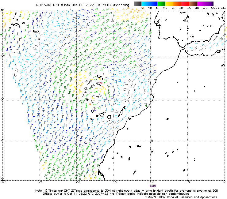
Closed circulation, winds up to 35 kts.
Closed circulation, winds up to 35 kts.
0 likes
-
TheEuropean
- Professional-Met
- Posts: 1797
- Age: 60
- Joined: Tue Sep 20, 2005 3:17 pm
- Location: Voerde, Germany
- Contact:

-
littlevince

- S2K Supporter

- Posts: 768
- Joined: Fri Oct 21, 2005 10:45 am
- Location: Portugal

-
HURAKAN

- Professional-Met
- Posts: 46084
- Age: 39
- Joined: Thu May 20, 2004 4:34 pm
- Location: Key West, FL
- Contact:
http://oiswww.eumetsat.org/SDDI/cgi/lis ... 0#controls
Click "play" and you will see the LPS moving SW and the convecting coming and going.
Click "play" and you will see the LPS moving SW and the convecting coming and going.
0 likes
-
P.K.
- Professional-Met
- Posts: 5149
- Joined: Thu Sep 23, 2004 5:57 pm
- Location: Watford, England
- Contact:
Re: Invest north of the Canaries
FQNT50 LFPW 110841
A
SECURITE
Weather bulletin for METAREA 2, METEO-FRANCE,
Toulouse, Thursday 11 October 2007 at 09 UTC.
- Wind speed in BEAUFORT SCALE - Sea : Total significant -
- Please be aware, wind gusts can be a further 40 percent stronger
than the averages given here, and maximum waves may be up to twice
the significant height.
Part 1 : WARNING :462
Part 2 : General synopsis, Thursday 11 at 00 UTC
Low 977 47N36W, moving northeast and deepening, expected 974 55N36W
by 11/12UTC, then 970 58N34W by 12/00UTC.
High 1031 48N10W, slowly moving northeast with little change,
expected 1028 50N07W by 12/12UTC.
New high expected 1024 39N40W by 12/00UTC, then little change.
Low 1012 hPa just south of Madeira islands, moving slowly south.
Expected over Canary Islands by 12/12 UTC.
Low 1007 in south of Mauritania, with little move.
ITCZ along 10N13W 07N29W 09N51W.
Part 3 : Area forecasts to Friday 12 at 12 UTC
FARADAY :
South or Southwest 7 or 8, locally 9 in far northwest, decreasing
West or Southwest 5 or 6 from west soon, then West or Southwest 4
to 6, occasionally 7 in far northwest. Severe gusts. Very rough or
high, becoming very rough or rough later. Rain or showers locally
thundery.
ROMEO :
Southerly 5 to 7, locally South or Southeast 3 to 5 in east,
decreasing Southerly 3 to 5 later. Moderate or rough, local very
rough in northwest. Rain or showers in west.
ALTAIR :
In west : West or Northwest 3 to 5, occasionally 6 in far north,
backing Westerly 3 or 4 in north later. In east : South or
Southwest 6 or 7, becoming Variable 3 to 5 soon, then decreasing 2
to 4 later Rough or very rough. Rain or showers locally thundery.
CHARCOT :
In west : South or Southeast 3 to 5, at times 6 in far north,
decreasing Southerly 2 to 4 later. In east : East or Northeast 3 to
5, at times 6 in far east, decreasing 2 to 4 later. Moderate or
rough, westerly swell. Rain or showers in west.
ACORES :
Southerly 4 to 6, locally Variable 3 to 5 in northwest , becoming
Variable 2 to 4 later. Moderate or rough in west or northwest
swell. Rain or showers locally thundery.
JOSEPHINE :
East or Northeast 3 to 5, decreasing 2 to 4 later. Moderate,
occasionally rough in northwesterly swell.
IRVING :
Northeasterly 3 to 5, locally Variable 2 to 4 in northwest.
Moderate, locally rough in northwest, northwesterly swell. Rain or
showers locally thundery.
MADEIRA :
Cyclonic 4 to 6, locally East or Northeast 3 to 5 in north,
becoming East or Northeast 3 to 5 later. Moderate or rough ,
decreasing later. Thundery showers.
PAZENN :
Easterly 2 to 4. Moderate in westerly swell.
IROISE, YEU, ROCHEBONNE :
East or Northeast 2 to 4. Moderate in westerly swell. Fog patches.
CANTABRICO :
In west : East or Northeast 4 or 5 In east : East or Northeast 2
to 4, locally Variable in southeast. Moderate in westerly swell.
Some rains. Fog patches.
FINISTERRE :
East or Northeast 4 to 6. Moderate or rough.
PORTO :
Northeasterly 5 or 6, decreasing 4 or 5 soon, then veering
Easterly 2 to 4 later. Moderate, occasionally rough, northwesterly
swell.
SAO VICENTE :
North or Northeast 2 to 4, veering Easterly 3 or 4 later. Moderate
in northwesterly swell.
CADIZ :
Mainly Northerly 2 or 3, veering Easterly 3 to 5 later, locally 6
near strait. Slight or moderate .
GIBRALTAR STRAIT :
Variable 2 to 4, becoming Easterly 4 or 5 soon, then 5 or 6 later
Moderate.
CASABLANCA :
East or Northeast 3 or 4. Moderate in northwesterly swell.
AGADIR :
Northerly 2 or 3, veering mainly Easterly 3 or 4, occasionally 5
later Moderate in northwesterly swell.
METEOR :
In far northwest, Variable 2 or 3. Elsewhere, Northeast 3 or 4,
backing Northerly 5 or 6 in Northeast soon. Becoming locally rough
in far northeast.
CANARIAS :
Cyclonic 2 to 4, occasionally 5, but temporarily North or Northwest
5 or 6 in far northwest at first. Locally rough in far northwest
decreasing. Thundery showers with gusts in northwest.
TARFAYA :
Northeasterly 2 to 4, becoming cyclonic 3 to 5 later. Slight or
moderate. Isolated thundery showers.
CAPE VERDE :
Northeasterly 4. Moderate.
CAP BLANC :
Northerly 4 or 5. Moderate.
CAP TIMIRIS :
Northerly 3 to 5, but West or Northwest 3 or 4 near southern
coasts. Moderate.
SIERRA LEONE :
Northeast 3 or 4, but North or Northwest 2 to 4 in northeast and
variable 2 to 4 in far south. Moderate. Thundersqualls with severe
gusts in south and in east.
GULF OF GUINEA :
Southerly 3 or 4. Moderate or rough in Southerly swell. Some
thundersqualls with severe gusts in north and in east.
POINTE NOIRE :
South or southeast 4 or 5, locally Southerly 2 to 4 in far east.
Rough in Southerly swell. Some thunderstorms near northern coasts.
Part 4 : outlook for next 24 hours :
No gale expected.
0 likes
Who is online
Users browsing this forum: No registered users and 80 guests