Big Severe Wx Outbreak around 10/18/07 in Plains
Moderator: S2k Moderators
Forum rules

The posts in this forum are NOT official forecast and should not be used as such. They are just the opinion of the poster and may or may not be backed by sound meteorological data. They are NOT endorsed by any professional institution or STORM2K.
-
Ed Mahmoud
Re:
CrazyC83 wrote:I wonder if they might pull the trigger and go HIGH risk for tomorrow at 1730Z?
If the WRF is right, and parts of extreme North Texas into Southern Kansas really will have helicity around 500 m^2/s^2, 50 knots winds just off the deck near the LFC, and CAPE over 1000 J/Kg, it might be the thing to do.
0 likes
-
PurdueWx80
- Professional-Met

- Posts: 2720
- Joined: Fri Aug 13, 2004 8:33 pm
- Location: Madison, WI
- Contact:
Re: Big Severe Wx Outbreak around 10/18/07 in Plains?
Pebbles wrote:Wanting a lil more input here from some of our more exp members. I'm located just a few miles east of Joliet, IL (sw of Chicago). Are we looking at a T-Storm aka tornado threat or more of a Derecho event here on Thursday.
Only wanting input because if this is looking to be a pretty widespread outbreak going to have to ask the hubby to move boxes we had temp put in the entrance to our crawlspace while having a new ac/heater put in. It's the second half of October! Wasn't expecting tornado sirens to be a possiblity this late in the season.
Strange weather this year... lotsa crazy storms this summer and now only one tree on our block is dropping leaves... and only a couple at that!

hey pebbles. with the low expected to be just to our west or northwest on thursday, i'd have to think there'll be a significant tornado threat in the chicagoland area since surface winds will stay out of the southeast - probably would happen in the late afternoon or evening, but more likely near or just after dark. the storm-relative shear will be really high, so if the sun comes out (as i expect it to since the dry slot will be overhead through the afternoon), temps will go into the mid-70s, it'll be plenty humid and instability will be sufficent for supercells. i'm not so sure i see a derecho because there is no strong linear forcing along the cold front. could easily see wind gusts to 80 mph in any storm that evening, though. and it'll be really windy wednesday night through friday anyway since the low is so strong. another concern from all this will be widespread heavy rain, perhaps 2-4" in a few spots. all that wind is gonna knock down a lot of leaves (i.e. clogged drains), so i would imagine there'll be some pretty good urban flooding in those places that see heavy rain.
the models aren't in perfect agreement on the small-scale details (which is to be expected this far our), but with the strength of the surface low pressure system and the humid nature of the air mass, i'd have to think there will be strong tornadoes somewhere from the upper midwest to the ohio valley on thursday.
0 likes

-
Ed Mahmoud
Re: Big Severe Wx Outbreak around 10/18/07 in Plains?
The antipasto for tomorrow into Thursday's big outbreak.
Cloudless skies in Northwest Texas.
Dewpoint 59ºF in Wichita Falls, 39ºF in Childress. Dewpoint around Childress dropped when the sun broke out and the air mixed, but has been rising in Wichita Falls, so I imagine a dry line may be starting to form up out somewhere in between.
WV loop suggests upper divergence already into New Mexico and heading for Texas.
I imagine that boundary would drift Westward as they tend to do at night unless something starts pushing it back.
Marginal instability, but a lot of wind in the Panhandle/West Texas later this evening.
0 likes

-
HarlequinBoy

- Category 5

- Posts: 1400
- Age: 35
- Joined: Wed Nov 29, 2006 1:57 am
- Location: Memphis

-
Weatherfreak14

- Category 5
- Posts: 1381
- Joined: Sat Sep 24, 2005 3:40 pm
- Location: Beaufort, SC
- Contact:
Re: Big Severe Wx Outbreak around 10/18/07 in Plains?
Wow, everything seemingly setting up for a big outbrak starting tommrow...... But yet not super outbreak. well i guess fall season is starting.
0 likes
-
CrazyC83
- Professional-Met
- Posts: 34315
- Joined: Tue Mar 07, 2006 11:57 pm
- Location: Deep South, for the first time!
Re: Big Severe Wx Outbreak around 10/18/07 in Plains?
Weatherfreak14 wrote:Wow, everything seemingly setting up for a big outbrak starting tommrow...... But yet not super outbreak. well i guess fall season is starting.
I'm thinking the southern half on Thursday will be more of a serial derecho, but I could be wrong...
0 likes
-
Ed Mahmoud
Re: Big Severe Wx Outbreak around 10/18/07 in Plains?
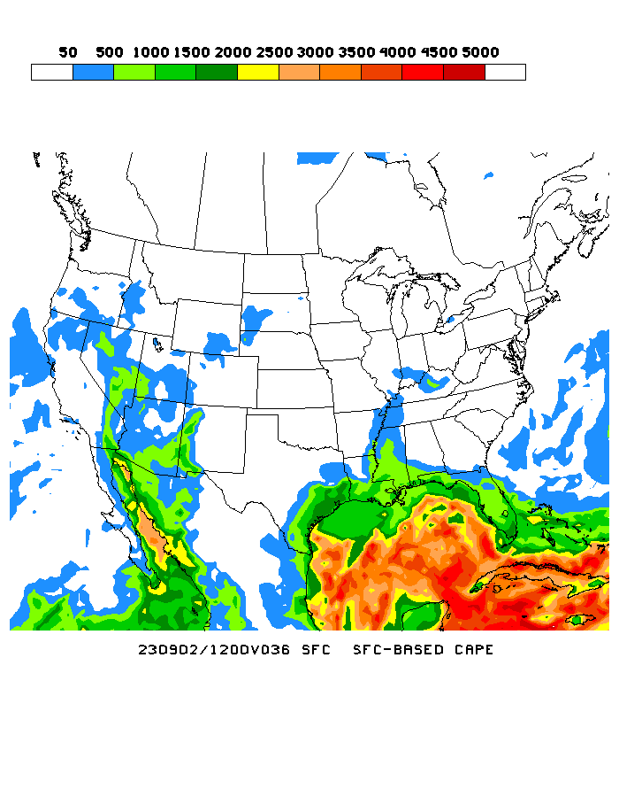
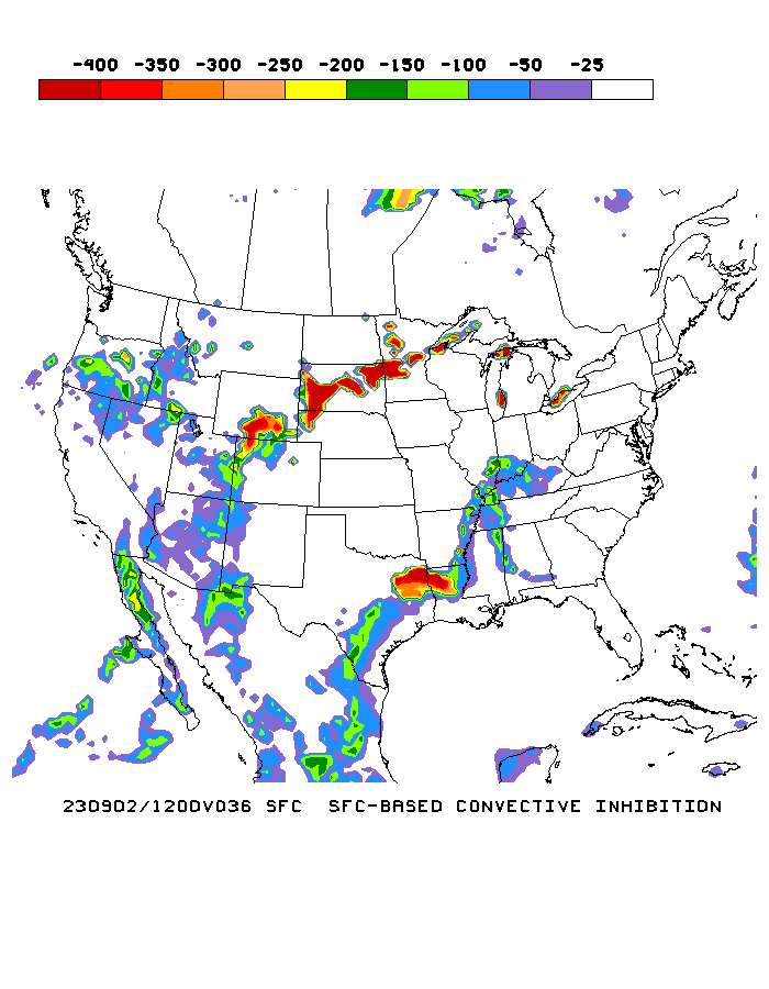
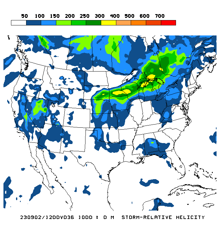
Early evening CAPE from 12Z WRF (Hot linked from model site, I can't remember my photobucket password/log-in)
Convective Inhibition
Simulated radar

0 to 1 km helicity
Convective Inhibition
Simulated radar
0 to 1 km helicity
0 likes
-
Ed Mahmoud
Re: Big Severe Wx Outbreak around 10/18/07 in Plains?
Relevant portion of Tulsa AFD
A LOT OF QUESTIONS STILL REMAIN CONCERNING HOW MUCH INSTABILITY
WILL BE AVAILABLE DURING THE AFTERNOON. IF CLOUDS FROM THE
MORNING SHOWERS AND THUNDERSTORMS PERSIST AND LIMIT HEATING
TO THE DEGREE THAT IT COULD LIMIT THE CONVECTION DURING THE
AFTERNOON OFF THE DRY LINE THAT FORMS TO THE WEST.
LIFTED INDEX VALUES WITH MODEST HEATING WILL STILL REACH
THE -4 TO -7 RANGE WITH DRY LINE APPROACHING THE AREA
LATE IN THE AFTERNOON. CAPE VALUES IN THE 750 TO 1000 J/KG
RANGE ARE EXPECTED WHICH WILL SUFFICIENT FOR THUNDERSTORMS
BUT QUESTION IF SHEAR COULD BE SO STRONG THAT THE UPDRAFT
STRENGTH WOULD BE ENOUGH TO PUNCH THROUGH THE SHEAR WITHOUT
BEING TORN APART. SOMEWHERE THERE WILL BE AN EQUILIBRIUM THAT
WILL ALLOW DISCRETE SUPERCELLS TO DEVELOP.
THE RAPID PROGRESSION OF THE DRY LINE WILL LIKELY LIMIT THE
WINDOW OF OPPORTUNITY FOR SEVERE DEVELOPMENT.
0 likes
-
Ed Mahmoud
Re: Big Severe Wx Outbreak around 10/18/07 in Plains?
back to tonights appetizer- satellite image shows storms trying to develop just West of Lobbock- based on this sounding, they will be slightly elevated, but with a TT over 50, good instability aloft, and enough dynamics for severe.

No MCD, yet.
No MCD, yet.
0 likes
-
Ed Mahmoud
Re: Big Severe Wx Outbreak around 10/18/07 in Plains?
Ed Mahmoud wrote:back to tonights appetizer- satellite image shows storms trying to develop just West of Lobbock- based on this sounding, they will be slightly elevated, but with a TT over 50, good instability aloft, and enough dynamics for severe.
No MCD, yet.
No bragging, but I have amazed people at a weblog with the initials LGF that has nothing to do with weather by predicting MCD before they happen.

MESOSCALE DISCUSSION 2085
NWS STORM PREDICTION CENTER NORMAN OK
1036 PM CDT TUE OCT 16 2007
AREAS AFFECTED...PARTS OF WRN TX THROUGH WRN OK
CONCERNING...SEVERE POTENTIAL...WATCH POSSIBLE
VALID 170336Z - 170530Z
STORMS MAY INCREASE IN COVERAGE AND EXPAND NEWD NEXT FEW HOURS.
PRIMARY THREAT WILL BE LARGE HAIL. INTENSITY TRENDS WILL CONTINUE TO
BE MONITORED FOR A POSSIBLE WW.
PARTIALLY MODIFIED GULF AIR WITH BOUNDARY LAYER DEWPOINTS IN THE
UPPER 50S IS RETURNING NWD ALONG A STRENGTHENING SLY LOW LEVEL JET
BENEATH 7.5 C/KM 850-500 MB LAPSE RATES ACROSS WRN TX. THIS PROCESS
HAS CONTRIBUTED TO AN AXIS OF 500 TO 1000 J/KG MUCAPE OVER NRN PARTS
OF WRN TX. WV IMAGERY AND RUC ANALYSIS SHOW A VORT MAX MOVING
THROUGH NM INTO THE TX PANHANDLE. FORCING FOR ASCENT AND
STRENGTHENING LOW LEVEL JET AHEAD OF THIS FEATURE IS PROMOTING THE
DEVELOPMENT OF ELEVATED STORMS OVER WRN PARTS OF THE TX PANHANDLE.
ACTIVITY WILL LIKELY INCREASE IN COVERAGE AND INTENSITY AND EXPAND
NEWD TOWARD WRN OK OVERNIGHT. EFFECTIVE SHEAR THROUGH THE CLOUD
LAYER IS SUFFICIENT FOR STORMS TO DEVELOP ROTATION...WHICH ALONG
WITH THE STEEP MID LEVEL LAPSE RATES WILL PROMOTE A THREAT FOR HAIL.
A POTENTIAL LIMITING FACTOR IS MARGINAL INSTABILITY...AND ISSUANCE
OF A WW WILL ULTIMATELY DEPEND ON CONVECTIVE TRENDS.
..DIAL.. 10/17/2007
ATTN...WFO...OUN...LUB...AMA...
0 likes
Return to “USA & Caribbean Weather”
Who is online
Users browsing this forum: UTSARoadrunner4 and 145 guests