This is starting to become the "Flashback Outbreak" in my mind, as every cell seems to bring up memories of historic outbreaks...
Cells have resembled those from the 1957 Flint outbreak, 1965 Palm Sunday outbreak, the 1974 Super Outbreak in areas, the June 1990 outbreak, Hurricane Ivan's tornadoes and the November 15, 2005 outbreak
Big Severe Wx Outbreak around 10/18/07 in Plains
Moderator: S2k Moderators
Forum rules

The posts in this forum are NOT official forecast and should not be used as such. They are just the opinion of the poster and may or may not be backed by sound meteorological data. They are NOT endorsed by any professional institution or STORM2K.

Storm relative helicities are still very high despite the evolution of the storms from discrete to more linear structures. Be very wary of the bookend vortices of bow echos spinning off tornadoes along with continued supercells just ahead of the squall line.
http://www.spc.noaa.gov/exper/mesoanalysis/s1/srh3.html
http://www.spc.noaa.gov/exper/mesoanalysis/s1/srh3.html
0 likes
-
MetSul Weather Center
- Tropical Storm

- Posts: 103
- Joined: Wed Dec 06, 2006 9:08 pm
- Location: São Leopoldo, Brazil
-
TexasSam

- Category 2

- Posts: 573
- Age: 66
- Joined: Thu Aug 28, 2003 12:16 am
- Location: Port Arthur, Texas
Re: Big Severe Wx Outbreak around 10/18/07 in Plains
WindRunner wrote:RL3AO wrote:Heres something ya don't see everyday.Code: Select all
BULLETIN - EAS ACTIVATION REQUESTED
SEVERE THUNDERSTORM WARNING
NATIONAL WEATHER SERVICE NASHVILLE TN
1019 PM CDT THU OCT 18 2007

THE NATIONAL WEATHER SERVICE IN NASHVILLE HAS ISSUED A

* SEVERE THUNDERSTORM WARNING FOR...
  CHEATHAM COUNTY IN TENNESSEE...
  THIS INCLUDES THE CITY OF ASHLAND CITY...
  WESTERN DAVIDSON COUNTY IN TENNESSEE...
  THIS INCLUDES THE CITY OF NASHVILLE...
  DICKSON COUNTY IN TENNESSEE...
  THIS INCLUDES THE CITY OF DICKSON...
  HICKMAN COUNTY IN TENNESSEE...
  THIS INCLUDES THE CITY OF CENTERVILLE...
  SOUTHEASTERN HUMPHREYS COUNTY IN TENNESSEE...
  NORTHWESTERN LAWRENCE COUNTY IN TENNESSEE...
  LEWIS COUNTY IN TENNESSEE...
  THIS INCLUDES THE CITY OF HOHENWALD...
  NORTHWESTERN MAURY COUNTY IN TENNESSEE...
  SOUTHEASTERN MONTGOMERY COUNTY IN TENNESSEE...
  PERRY COUNTY IN TENNESSEE...
  THIS INCLUDES THE CITY OF LINDEN...
  ROBERTSON COUNTY IN TENNESSEE...
  THIS INCLUDES THE CITY OF SPRINGFIELD...
  NORTHWESTERN SUMNER COUNTY IN TENNESSEE...
  WAYNE COUNTY IN TENNESSEE...
  THIS INCLUDES THE CITY OF WAYNESBORO...
  WESTERN WILLIAMSON COUNTY IN TENNESSEE...

* UNTIL 1115 PM CDT
Just saw that . . . that's classic. 14 counties at once.
Need to print that one out for use next spring!
0 likes
-
WindRunner

- Category 5

- Posts: 5803
- Age: 35
- Joined: Fri Jul 29, 2005 8:07 pm
- Location: Warrenton, VA, but Albany, NY for school
- Contact:

-
CrazyC83
- Professional-Met

- Posts: 34315
- Joined: Tue Mar 07, 2006 11:57 pm
- Location: Deep South, for the first time!
SEL7
URGENT - IMMEDIATE BROADCAST REQUESTED
TORNADO WATCH NUMBER 727
NWS STORM PREDICTION CENTER NORMAN OK
1150 PM EDT THU OCT 18 2007
THE NWS STORM PREDICTION CENTER HAS ISSUED A
TORNADO WATCH FOR PORTIONS OF
EASTERN LOWER MICHIGAN
LAKE ERIE
LAKE HURON
EFFECTIVE THIS THURSDAY NIGHT AND FRIDAY MORNING FROM 1150 PM
UNTIL 600 AM EDT.
TORNADOES...HAIL TO 1.5 INCHES IN DIAMETER...THUNDERSTORM WIND
GUSTS TO 70 MPH...AND DANGEROUS LIGHTNING ARE POSSIBLE IN THESE
AREAS.
THE TORNADO WATCH AREA IS APPROXIMATELY ALONG AND 60 STATUTE
MILES EAST AND WEST OF A LINE FROM 20 MILES EAST NORTHEAST OF BAD
AXE MICHIGAN TO 40 MILES SOUTH SOUTHEAST OF JACKSON MICHIGAN.
FOR A COMPLETE DEPICTION OF THE WATCH SEE THE ASSOCIATED WATCH
OUTLINE UPDATE (WOUS64 KWNS WOU7).
REMEMBER...A TORNADO WATCH MEANS CONDITIONS ARE FAVORABLE FOR
TORNADOES AND SEVERE THUNDERSTORMS IN AND CLOSE TO THE WATCH
AREA. PERSONS IN THESE AREAS SHOULD BE ON THE LOOKOUT FOR
THREATENING WEATHER CONDITIONS AND LISTEN FOR LATER STATEMENTS
AND POSSIBLE WARNINGS.
OTHER WATCH INFORMATION...CONTINUE...WW 722...WW 724...WW
725...WW 726...
DISCUSSION...SUPERCELL STORMS CONTINUE TO AFFECT PARTS OF EASTERN
LOWER MI. THESE STORMS WILL PERSIST FOR SEVERAL MORE HOURS...IN
REGION OF VERY FAVORABLE VERTICAL SHEAR AND SUFFICIENT INSTABILITY.
DAMAGING WINDS AND ISOLATED TORNADOES WILL REMAIN A RISK THROUGH THE
EARLY MORNING HOURS.
AVIATION...TORNADOES AND A FEW SEVERE THUNDERSTORMS WITH HAIL
SURFACE AND ALOFT TO 1.5 INCHES. EXTREME TURBULENCE AND SURFACE
WIND GUSTS TO 60 KNOTS. A FEW CUMULONIMBI WITH MAXIMUM TOPS TO
500. MEAN STORM MOTION VECTOR 24035.
...HART
Note: Click for Watch Status Reports.
WOUS64 KWNS 190344
WOU7
BULLETIN - IMMEDIATE BROADCAST REQUESTED
TORNADO WATCH OUTLINE UPDATE FOR WT 727
NWS STORM PREDICTION CENTER NORMAN OK
1150 PM EDT THU OCT 18 2007
TORNADO WATCH 727 IS IN EFFECT UNTIL 600 AM EDT FOR THE
FOLLOWING LOCATIONS
MIC017-025-037-045-049-063-065-075-087-091-093-099-115-125-145-
147-151-155-157-161-163-191000-
/O.NEW.KWNS.TO.A.0727.071019T0350Z-071019T1000Z/
MI
. MICHIGAN COUNTIES INCLUDED ARE
BAY CALHOUN CLINTON
EATON GENESEE HURON
INGHAM JACKSON LAPEER
LENAWEE LIVINGSTON MACOMB
MONROE OAKLAND SAGINAW
SANILAC SHIAWASSEE ST. CLAIR
TUSCOLA WASHTENAW WAYNE
LCZ422-423-460-LEZ444-LHZ421-422-441-442-443-462-463-464-
191000-
/O.NEW.KWNS.TO.A.0727.071019T0350Z-071019T1000Z/
CW
. ADJACENT COASTAL WATERS INCLUDED ARE
ST. CLAIR RIVER
DETROIT RIVER
LAKE ST. CLAIR OPEN LAKE (U.S. PORTION)
MICHIGAN WATERS OF LAKE ERIE FROM DETROIT RIVER TO NORTH CAPE MI
OUTER SAGINAW BAY SW OF ALABASTER TO PORT AUSTIN MI TO INNER
SAGINAW BAY
INNER SAGINAW BAY SW OF POINT AU GRES TO BAY PORT MI
PORT AUSTIN TO HARBOR BEACH MI
HARBOR BEACH TO PORT SANILAC MI
PORT SANILAC TO PORT HURON MI
LAKE HURON FROM PORT AUSTIN TO HARBOR BEACH 5NM OFF SHORE TO THE
US/CANADIAN BORDER
LAKE HURON FROM HARBOR BEACH TO PORT SANILAC 5NM OFF SHORE TO
US/CANADIAN BORDER
LAKE HURON FROM PORT SANILAC TO PORT HURON 5NM OFF SHORE TO
US/CANADIAN BORDER
ATTN...WFO...DTX...GRR...
Note: The Aviation Watch (SAW) product is an approximation to the watch area. The actual watch is depicted by the shaded areas.
SAW7
WW 727 TORNADO MI LE LH 190350Z - 191000Z
AXIS..60 STATUTE MILES EAST AND WEST OF LINE..
20ENE BAX/BAD AXE MI/ - 40SSE JXN/JACKSON MI/
..AVIATION COORDS.. 50NM E/W /38N ECK - 46SW DXO/
HAIL SURFACE AND ALOFT..1.5 INCHES. WIND GUSTS..60 KNOTS.
MAX TOPS TO 500. MEAN STORM MOTION VECTOR 24035.
LAT...LON 43888141 41728301 41728533 43888381
THIS IS AN APPROXIMATION TO THE WATCH AREA. FOR A
COMPLETE DEPICTION OF THE WATCH SEE WOUS64 KWNS
FOR WOU7.
Watch 727 Status Report Message has not been issued yet.
URGENT - IMMEDIATE BROADCAST REQUESTED
TORNADO WATCH NUMBER 727
NWS STORM PREDICTION CENTER NORMAN OK
1150 PM EDT THU OCT 18 2007
THE NWS STORM PREDICTION CENTER HAS ISSUED A
TORNADO WATCH FOR PORTIONS OF
EASTERN LOWER MICHIGAN
LAKE ERIE
LAKE HURON
EFFECTIVE THIS THURSDAY NIGHT AND FRIDAY MORNING FROM 1150 PM
UNTIL 600 AM EDT.
TORNADOES...HAIL TO 1.5 INCHES IN DIAMETER...THUNDERSTORM WIND
GUSTS TO 70 MPH...AND DANGEROUS LIGHTNING ARE POSSIBLE IN THESE
AREAS.
THE TORNADO WATCH AREA IS APPROXIMATELY ALONG AND 60 STATUTE
MILES EAST AND WEST OF A LINE FROM 20 MILES EAST NORTHEAST OF BAD
AXE MICHIGAN TO 40 MILES SOUTH SOUTHEAST OF JACKSON MICHIGAN.
FOR A COMPLETE DEPICTION OF THE WATCH SEE THE ASSOCIATED WATCH
OUTLINE UPDATE (WOUS64 KWNS WOU7).
REMEMBER...A TORNADO WATCH MEANS CONDITIONS ARE FAVORABLE FOR
TORNADOES AND SEVERE THUNDERSTORMS IN AND CLOSE TO THE WATCH
AREA. PERSONS IN THESE AREAS SHOULD BE ON THE LOOKOUT FOR
THREATENING WEATHER CONDITIONS AND LISTEN FOR LATER STATEMENTS
AND POSSIBLE WARNINGS.
OTHER WATCH INFORMATION...CONTINUE...WW 722...WW 724...WW
725...WW 726...
DISCUSSION...SUPERCELL STORMS CONTINUE TO AFFECT PARTS OF EASTERN
LOWER MI. THESE STORMS WILL PERSIST FOR SEVERAL MORE HOURS...IN
REGION OF VERY FAVORABLE VERTICAL SHEAR AND SUFFICIENT INSTABILITY.
DAMAGING WINDS AND ISOLATED TORNADOES WILL REMAIN A RISK THROUGH THE
EARLY MORNING HOURS.
AVIATION...TORNADOES AND A FEW SEVERE THUNDERSTORMS WITH HAIL
SURFACE AND ALOFT TO 1.5 INCHES. EXTREME TURBULENCE AND SURFACE
WIND GUSTS TO 60 KNOTS. A FEW CUMULONIMBI WITH MAXIMUM TOPS TO
500. MEAN STORM MOTION VECTOR 24035.
...HART
SEL7
URGENT - IMMEDIATE BROADCAST REQUESTED
TORNADO WATCH NUMBER 727
NWS STORM PREDICTION CENTER NORMAN OK
1150 PM EDT THU OCT 18 2007
THE NWS STORM PREDICTION CENTER HAS ISSUED A
TORNADO WATCH FOR PORTIONS OF
EASTERN LOWER MICHIGAN
LAKE ERIE
LAKE HURON
EFFECTIVE THIS THURSDAY NIGHT AND FRIDAY MORNING FROM 1150 PM
UNTIL 600 AM EDT.
TORNADOES...HAIL TO 1.5 INCHES IN DIAMETER...THUNDERSTORM WIND
GUSTS TO 70 MPH...AND DANGEROUS LIGHTNING ARE POSSIBLE IN THESE
AREAS.
THE TORNADO WATCH AREA IS APPROXIMATELY ALONG AND 60 STATUTE
MILES EAST AND WEST OF A LINE FROM 20 MILES EAST NORTHEAST OF BAD
AXE MICHIGAN TO 40 MILES SOUTH SOUTHEAST OF JACKSON MICHIGAN.
FOR A COMPLETE DEPICTION OF THE WATCH SEE THE ASSOCIATED WATCH
OUTLINE UPDATE (WOUS64 KWNS WOU7).
REMEMBER...A TORNADO WATCH MEANS CONDITIONS ARE FAVORABLE FOR
TORNADOES AND SEVERE THUNDERSTORMS IN AND CLOSE TO THE WATCH
AREA. PERSONS IN THESE AREAS SHOULD BE ON THE LOOKOUT FOR
THREATENING WEATHER CONDITIONS AND LISTEN FOR LATER STATEMENTS
AND POSSIBLE WARNINGS.
OTHER WATCH INFORMATION...CONTINUE...WW 722...WW 724...WW
725...WW 726...
DISCUSSION...SUPERCELL STORMS CONTINUE TO AFFECT PARTS OF EASTERN
LOWER MI. THESE STORMS WILL PERSIST FOR SEVERAL MORE HOURS...IN
REGION OF VERY FAVORABLE VERTICAL SHEAR AND SUFFICIENT INSTABILITY.
DAMAGING WINDS AND ISOLATED TORNADOES WILL REMAIN A RISK THROUGH THE
EARLY MORNING HOURS.
AVIATION...TORNADOES AND A FEW SEVERE THUNDERSTORMS WITH HAIL
SURFACE AND ALOFT TO 1.5 INCHES. EXTREME TURBULENCE AND SURFACE
WIND GUSTS TO 60 KNOTS. A FEW CUMULONIMBI WITH MAXIMUM TOPS TO
500. MEAN STORM MOTION VECTOR 24035.
...HART
Note: Click for Watch Status Reports.
WOUS64 KWNS 190344
WOU7
BULLETIN - IMMEDIATE BROADCAST REQUESTED
TORNADO WATCH OUTLINE UPDATE FOR WT 727
NWS STORM PREDICTION CENTER NORMAN OK
1150 PM EDT THU OCT 18 2007
TORNADO WATCH 727 IS IN EFFECT UNTIL 600 AM EDT FOR THE
FOLLOWING LOCATIONS
MIC017-025-037-045-049-063-065-075-087-091-093-099-115-125-145-
147-151-155-157-161-163-191000-
/O.NEW.KWNS.TO.A.0727.071019T0350Z-071019T1000Z/
MI
. MICHIGAN COUNTIES INCLUDED ARE
BAY CALHOUN CLINTON
EATON GENESEE HURON
INGHAM JACKSON LAPEER
LENAWEE LIVINGSTON MACOMB
MONROE OAKLAND SAGINAW
SANILAC SHIAWASSEE ST. CLAIR
TUSCOLA WASHTENAW WAYNE
LCZ422-423-460-LEZ444-LHZ421-422-441-442-443-462-463-464-
191000-
/O.NEW.KWNS.TO.A.0727.071019T0350Z-071019T1000Z/
CW
. ADJACENT COASTAL WATERS INCLUDED ARE
ST. CLAIR RIVER
DETROIT RIVER
LAKE ST. CLAIR OPEN LAKE (U.S. PORTION)
MICHIGAN WATERS OF LAKE ERIE FROM DETROIT RIVER TO NORTH CAPE MI
OUTER SAGINAW BAY SW OF ALABASTER TO PORT AUSTIN MI TO INNER
SAGINAW BAY
INNER SAGINAW BAY SW OF POINT AU GRES TO BAY PORT MI
PORT AUSTIN TO HARBOR BEACH MI
HARBOR BEACH TO PORT SANILAC MI
PORT SANILAC TO PORT HURON MI
LAKE HURON FROM PORT AUSTIN TO HARBOR BEACH 5NM OFF SHORE TO THE
US/CANADIAN BORDER
LAKE HURON FROM HARBOR BEACH TO PORT SANILAC 5NM OFF SHORE TO
US/CANADIAN BORDER
LAKE HURON FROM PORT SANILAC TO PORT HURON 5NM OFF SHORE TO
US/CANADIAN BORDER
ATTN...WFO...DTX...GRR...
Note: The Aviation Watch (SAW) product is an approximation to the watch area. The actual watch is depicted by the shaded areas.
SAW7
WW 727 TORNADO MI LE LH 190350Z - 191000Z
AXIS..60 STATUTE MILES EAST AND WEST OF LINE..
20ENE BAX/BAD AXE MI/ - 40SSE JXN/JACKSON MI/
..AVIATION COORDS.. 50NM E/W /38N ECK - 46SW DXO/
HAIL SURFACE AND ALOFT..1.5 INCHES. WIND GUSTS..60 KNOTS.
MAX TOPS TO 500. MEAN STORM MOTION VECTOR 24035.
LAT...LON 43888141 41728301 41728533 43888381
THIS IS AN APPROXIMATION TO THE WATCH AREA. FOR A
COMPLETE DEPICTION OF THE WATCH SEE WOUS64 KWNS
FOR WOU7.
Watch 727 Status Report Message has not been issued yet.
0 likes
-
CrazyC83
- Professional-Met
- Posts: 34315
- Joined: Tue Mar 07, 2006 11:57 pm
- Location: Deep South, for the first time!
Re: Re:
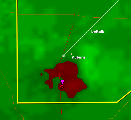
RL3AO wrote:WindRunner wrote:Hmm . . . the Auburn cell is now rainwrapping as it passes about 2 miles south of the city . . . and still no TOR?
Whoever "JC" is at IWX needs to wake up . . .
Anyone there should treat this as a tornado warning, regardless of IWX...
0 likes
-
CrazyC83
- Professional-Met
- Posts: 34315
- Joined: Tue Mar 07, 2006 11:57 pm
- Location: Deep South, for the first time!
MESOSCALE DISCUSSION 2121
NWS STORM PREDICTION CENTER NORMAN OK
1050 PM CDT THU OCT 18 2007
AREAS AFFECTED...CNTRL KY...WCNTRL/SWRN OH
CONCERNING...TORNADO WATCH 725...
VALID 190350Z - 190515Z
THE SEVERE WEATHER THREAT FOR TORNADO WATCH 725 CONTINUES.
VWP TIME SERIES FROM ILN/LVX SUGGEST THAT THE WINDS IN ROUGHLY THE
3-6 KM LAYER HAVE BEEN BACKING SINCE 01Z...INDICATIVE OF THE UPR
TROUGH BECOMING MORE NEGATIVELY TILTED OVER THE GRTLKS REGION. THIS
HAS PROBABLY CONTRIBUTED TO STORM MODE BECOMING INCREASINGLY LINEAR
JUST SE OF THE OH RVR VLY FROM NCNTRL KY SWWD INTO THE TN VLY AT
LATE EVENING. AT THE SAME TIME...HOWEVER...BULK SHEAR WAS AOA 60
KTS AND WILL CONTINUE TO SUPPORT EMBEDDED SUPERCELL STRUCTURES
WITHIN THE LINE. ILN VWP DERIVED HODOGRAPH SUGGESTS A 0-1KM SRH AOA
290 M2/S2. SUSPECT THAT THE STRONGEST POTENTIAL FOR TORNADOES WILL
EXIST WITH MORE DISCRETE STRUCTURES THAT MANAGE TO THRIVE WITHIN THE
EXPANDING LINEAR MCS. OTHERWISE...DMGG WIND GUSTS WILL PROBABLY
BECOME MORE OF AN ISSUE WITH TIME TONIGHT AS THE STORMS TRANSLATE
DOWNSTREAM INTO SRN OH AND CNTRL/BLUEGRASS REGION OF ECNTRL KY.
..RACY.. 10/19/2007
ATTN...WFO...JKL...ILN...LMK...IND...
39838509 40498447 40478355 40228322 39688314 39128332
38248398 37408464 36908537 36828598 36978690
0 likes

Re: Big Severe Wx Outbreak around 10/18/07 in Plains
MetSul Weather Center wrote:Any local TV streaming to watch ?
http://www.wcpo.com/content/mediacenter ... acker.aspx
0 likes
-
WindRunner
- Category 5
- Posts: 5803
- Age: 35
- Joined: Fri Jul 29, 2005 8:07 pm
- Location: Warrenton, VA, but Albany, NY for school
- Contact:
Re: Re:
CrazyC83 wrote:
Anyone there should treat this as a tornado warning, regardless of IWX...
SVS from 10 minutes ago . . .
INC033-190430-
/O.CON.KIWX.SV.W.0165.000000T0000Z-071019T0430Z/
DE KALB IN-
1147 PM EDT THU OCT 18 2007
...A SEVERE THUNDERSTORM WARNING REMAINS IN EFFECT UNTIL 1230 AM EDT
FOR DE KALB COUNTY...
AT 1142 PM EDT...NATIONAL WEATHER SERVICE DOPPLER RADAR CONTINUED TO
INDICATE A SEVERE THUNDERSTORM CAPABLE OF PRODUCING PENNY SIZE
HAIL...AND DAMAGING WINDS IN EXCESS OF 60 MPH. THIS SEVERE STORM WAS
LOCATED NEAR SAINT JOHNS...OR ABOUT 4 MILES SOUTH OF GARRETT...AND
MOVING NORTHEAST AT 45 MPH.
OTHER LOCATIONS IN THE WARNING INCLUDE BUT ARE NOT LIMITED TO
CORUNNA...AUBURN...SEDAN...FAIRFIELD CENTER...CONCORD...HELMER...ST.
JOE...SAINT JOE...WATERLOO...MOORE...HUDSON...ASHLEY...NEWVILLE...
STEUBENVILLE...BUTLER AND ARTIC.
DOPPLER RADAR HAS INDICATED SOME WEAK ROTATION WITHIN THIS SEVERE
THUNDERSTORM. SEVERE THUNDERSTORMS CAN PRODUCE TORNADOES WITH LITTLE
OR NO WARNING. IF A TORNADO IS SPOTTED...ACT QUICKLY AND MOVE TO A
PLACE OF SAFETY IN A STURDY STRUCTURE...SUCH AS A BASEMENT OR SMALL
INTERIOR ROOM.
IF YOU HAVE SEVERE WEATHER TO REPORT...YOU CAN CALL YOUR LOCAL LAW
ENFORCEMENT AGENCY FOR RELAY TO THE NATIONAL WEATHER SERVICE.
A TORNADO WATCH REMAINS IN EFFECT UNTIL MIDNIGHT EDT FRIDAY MORNING
FOR NORTHERN INDIANA AND SOUTHERN MICHIGAN.
LAT...LON 4137 8480 4128 8495 4128 8496 4128 8506
4128 8507 4128 8519 4149 8519 4154 8516
4153 8480
TIME...MOT...LOC 0347Z 230DEG 40KT 4134 8506
$$
JC
0 likes
-
Ed Mahmoud
Re: Big Severe Wx Outbreak around 10/18/07 in Plains
WindRunner wrote:Ed Mahmoud wrote:Tornadic cell less than 30 minutes from Cinncinnati metro...
What are you looking at there? And you do know that Cincy has its own radar (KILN) if it's better for whatever storm you're looking at . . .
The Indy radar has gone dark. But there was a hook.
Where do you get all the awesome radar imagery us mere mortals can't find?
0 likes
-
CrazyC83
- Professional-Met
- Posts: 34315
- Joined: Tue Mar 07, 2006 11:57 pm
- Location: Deep South, for the first time!
This may have peaked, but it is definitely not over.
One bad tornado in a bad place could be very devastating; that is all it takes and those are not uncommon in the overnight hours. I wouldn't sleep in a mobile home or weak structure tonight if I were in northern Alabama, Middle Tennessee, eastern Kentucky, western/central Ohio or southwestern Ontario. Also best to sleep with the weather radio.
One bad tornado in a bad place could be very devastating; that is all it takes and those are not uncommon in the overnight hours. I wouldn't sleep in a mobile home or weak structure tonight if I were in northern Alabama, Middle Tennessee, eastern Kentucky, western/central Ohio or southwestern Ontario. Also best to sleep with the weather radio.
Last edited by CrazyC83 on Thu Oct 18, 2007 11:03 pm, edited 1 time in total.
0 likes
-
Ed Mahmoud
Re: Big Severe Wx Outbreak around 10/18/07 in Plains
Ed Mahmoud wrote:WindRunner wrote:Ed Mahmoud wrote:Tornadic cell less than 30 minutes from Cinncinnati metro...
What are you looking at there? And you do know that Cincy has its own radar (KILN) if it's better for whatever storm you're looking at . . .
The Indy radar has gone dark. But there was a hook.
Where do you get all the awesome radar imagery us mere mortals can't find?
It seems to have lost some oommph in the last 15 minutes or so...
0 likes
-
WindRunner
- Category 5
- Posts: 5803
- Age: 35
- Joined: Fri Jul 29, 2005 8:07 pm
- Location: Warrenton, VA, but Albany, NY for school
- Contact:
Re: Big Severe Wx Outbreak around 10/18/07 in Plains
Ed Mahmoud wrote:Ed Mahmoud wrote:The Indy radar has gone dark. But there was a hook.
Where do you get all the awesome radar imagery us mere mortals can't find?
It seems to have lost some oommph in the last 15 minutes or so...
If you were talking about that one cell in the county SW of Cincy, then yeah, that was looking possibly bad for a while. Reports are in of 3/4 inch hail downtown, but people survive that.
As for the radar imagery, it's not anything different than what you linked to initially . . . just run through some software. Check out http://www.grlevelx.com/ to see his different pieces of software - what you're seeing from me is courtesy of GR2AE, the top-of-the-line piece.
0 likes
-
WindRunner
- Category 5
- Posts: 5803
- Age: 35
- Joined: Fri Jul 29, 2005 8:07 pm
- Location: Warrenton, VA, but Albany, NY for school
- Contact:
Re:
RL3AO wrote:They have issued a TOR for that cell we've been watching and complaining about.
Saw that . . . but looking at the cell at the time he issued the warning, I don't know if I would have done it. It's certainly interesting, but that is only marginally worth a warning right now.
0 likes
-
GeneratorPower

- S2K Supporter

- Posts: 1648
- Age: 46
- Joined: Sun Dec 18, 2005 11:48 pm
- Location: Huntsville, AL
Re: Big Severe Wx Outbreak around 10/18/07 in Plains
MetSul Weather Center wrote:Any local TV streaming to watch ?
http://www.waff.com
Huntsville, Alabama USA
0 likes
Return to “USA & Caribbean Weather”
Who is online
Users browsing this forum: Google Adsense [Bot] and 71 guests