Are you kidding?destruction92 wrote:I think its safe to say that Florida is officially in the clear according to our pro-mets on the board.
Good work Derek and Wxman57!
Hurricane NOEL : Discussions & Images
Moderator: S2k Moderators
-
NcentralFlaguy
- Tropical Storm

- Posts: 136
- Joined: Sun Jun 17, 2007 9:36 am
Re: Tropical Depression SIXTEEN Models Thread
0 likes


Re: Tropical Depression SIXTEEN : Discussions & Images
THis could be potentially egg on the face of the NHC. You may have a eye form on a depression/weak TS in 4-6 hours
0 likes
-
cycloneye

- Admin

- Posts: 149588
- Age: 69
- Joined: Thu Oct 10, 2002 10:54 am
- Location: San Juan, Puerto Rico
Re: Tropical Depression SIXTEEN : Discussions & Images
The Latest at 15:45 UTC:

Looking better by the hour.
Looking better by the hour.
0 likes
-
HURAKAN

- Professional-Met

- Posts: 46084
- Age: 39
- Joined: Thu May 20, 2004 4:34 pm
- Location: Key West, FL
- Contact:
Re: Re:
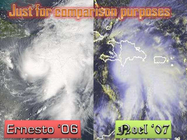
CrazyC83 wrote:HURAKAN wrote:WmE wrote:The appearence is reminiscent of Ernesto last year.
That Ernesto was a 55-60 kt TS at that moment...
The comparison is for appearence, not intensity.
0 likes


Re: Re:
WmE wrote:Cyclone1 wrote:Wow... this is extremely impressive. If this isn't named at 2 then I will spend the rest of the day talking like a little school girl.
LOL. Well, They will probably wait for the recon observations until they upgrade it.
2:00. They can't leave a storm this organized a depression for much longer. If it's not named at two, i'll talk like a little school girl until it's upgraded. (Now watch it dissipate)
0 likes
-
destruction92
- Category 1

- Posts: 312
- Joined: Sun Jul 22, 2007 10:43 pm
Re: Tropical Depression SIXTEEN : Discussions & Images
this time of year florida is more targeted than any other part of the mainland U.S. With that said, i think the main reason why florida got spared is the location td 16 formed: the NE carribean sea...i dont know of any system that has formed so far north and east in the carribean and actuall struck florida this late in october.
usually all the late season october/november florida threats come from the NW carribean BUT NOT the NE carribean.
i think that this is far from being a close call.
i am so confident now that i am almost willing to make a bet in a las vegas casino right now that TD 16 is no threat whatsoever to the mainland U.S.
0 likes
-
cycloneye
- Admin
- Posts: 149588
- Age: 69
- Joined: Thu Oct 10, 2002 10:54 am
- Location: San Juan, Puerto Rico
Re: Tropical Depression SIXTEEN Recon discussion
Or maybe they are communicating with the countries to have permision to fly in their airspace as this will track near them.Also Cuba will be an issue later on in terms of flying over them.
0 likes
-
CrazyC83
- Professional-Met
- Posts: 34315
- Joined: Tue Mar 07, 2006 11:57 pm
- Location: Deep South, for the first time!
Re: Tropical Depression SIXTEEN : Discussions & Images
destruction92 wrote:this time of year florida is more targeted than any other part of the mainland U.S. With that said, i think the main reason why florida got spared is the location td 16 formed: the NE carribean sea...i dont know of any system that has formed so far north and east in the carribean and actuall struck florida this late in october.
usually all the late season october/november florida threats come from the NW carribean BUT NOT the NE carribean.
i think that this is far from being a close call.
i am so confident now that i am almost willing to make a bet in a las vegas casino right now that TD 16 is no threat whatsoever to the mainland U.S.
I'm in agreement. I think it will ride the channel between Haiti and Cuba, and then out to sea...
0 likes
-
tolakram
- Admin
- Posts: 20186
- Age: 62
- Joined: Sun Aug 27, 2006 8:23 pm
- Location: Florence, KY (name is Mark)
Re: Tropical Depression SIXTEEN : Discussions & Images
I'm not going to use the E word but ...
AVN:

DVORAK:

JSL:

And look at what appears to be outflow on the west side of the storm.
http://www.ssd.noaa.gov/goes/flt/t1/loop-ft.html
AVN:
DVORAK:
JSL:
And look at what appears to be outflow on the west side of the storm.
http://www.ssd.noaa.gov/goes/flt/t1/loop-ft.html
0 likes
-
destruction92
- Category 1
- Posts: 312
- Joined: Sun Jul 22, 2007 10:43 pm
Re:
Cyclone1 wrote:No... Not an...There's no way...
Wow... I'm not gonna say the "R" and "I" words but...
i'll say it....RAPID INTENSIFICATION.
Derek called this out already....no surprise here.
What would really surprise me though is if TD16 made a mainland U.S. landfall.
0 likes
-
destruction92
- Category 1
- Posts: 312
- Joined: Sun Jul 22, 2007 10:43 pm
Re: Tropical Depression SIXTEEN Models Thread
NcentralFlaguy wrote:Are you kidding?destruction92 wrote:I think its safe to say that Florida is officially in the clear according to our pro-mets on the board.
Good work Derek and Wxman57!
no, i am not kidding. neither is Wxman57 who agrees with my opinion.
0 likes
-
JonathanBelles
- Professional-Met
- Posts: 11430
- Age: 35
- Joined: Sat Dec 24, 2005 9:00 pm
- Location: School: Florida State University (Tallahassee, FL) Home: St. Petersburg, Florida
- Contact:

Re: Tropical Depression SIXTEEN : Discussions & Images
destruction92 wrote:this time of year florida is more targeted than any other part of the mainland U.S. With that said, i think the main reason why florida got spared is the location td 16 formed: the NE carribean sea...i dont know of any system that has formed so far north and east in the carribean and actuall struck florida this late in october.
usually all the late season october/november florida threats come from the NW carribean BUT NOT the NE carribean.
i think that this is far from being a close call.
i am so confident now that i am almost willing to make a bet in a las vegas casino right now that TD 16 is no threat whatsoever to the mainland U.S.
Derek and Wxman57, didn't conclusively say that this storm will not hit FL or the US Mainland. Even If it did intensify alot and head more NW now, it could turn back in west or WNW for while with ridge building back to north of the storm, before another cold front moves off the East Coast later in the week. This is what the latest 6z and 12z GFS are showing now.
0 likes
-
wxman57

- Moderator-Pro Met

- Posts: 23175
- Age: 68
- Joined: Sat Jun 21, 2003 8:06 pm
- Location: Houston, TX (southwest)
Re: Tropical Depression SIXTEEN : Discussions & Images
Here's a little higher-res shot with 1 deg lat/lon lines. I plotted the NHC's 15Z position (yellow X) and where the low-level cloud motions (yellow arrows) seem to indicate a center - maybe 16.8N/71.5W. Looking at a satellite loop, it's hard to imagine this storm passing south of Haiti. I think the GFDL and HWRF may be right in the early northward turn. I also think it's a TS now. And I'm not biased at all by the fact that I bet my boss lunch that it would become a TS. 

0 likes
-
HURAKAN
- Professional-Met
- Posts: 46084
- Age: 39
- Joined: Thu May 20, 2004 4:34 pm
- Location: Key West, FL
- Contact:
868
NOUS42 KNHC 281615
WEATHER RECONNAISSANCE FLIGHTS
CARCAH, NATIONAL HURRICANE CENTER, MIAMI, FL.
1215 PM EDT SUN 28 OCTOBER 2007
SUBJECT: TROPICAL CYCLONE PLAN OF THE DAY (TCPOD)
VALID 29/1100Z TO 30/1100Z OCTOBER 2007
TCPOD NUMBER.....07-156
I. ATLANTIC REQUIREMENTS
1. TROPICAL DEPRESSION 16
FLIGHT ONE - TEAL 70
A. 29/1800Z
B. AFXXX 0316A CYCLONE
C. 29/1315Z
D. 18.5N 75.8W
E. FROM 1730Z TO 2300Z
F. SFC TO 10,000 FT
FLIGHT TWO NOAA 49
A.30/0000Z
B.NOAA9 0416A CYCLONE
C.29/1730Z
D.NA
E.NA
F.41,000 FT TO 45,000
FLIGHT THREE - TEAL 71
A. 30/0600Z
B. AFXXX 0516A CYCLONE
C. 29/0045Z
D. 19.5N 77.3W
E. FROM 0500Z TO 0900Z
F. SFC TO 10,000FT
2. SUCCEEDING DAY OUTLOOK: CONTINUE 12 HRLY FIXES IF SYSTEM
WARRANTS.
II.PACIFIC REQUIREMENTS
1. NEGATIVE RECONNAISSANCE REQUIREMENTS.
2. OUTLOOK FOR SUCCEEDING DAY.....NEGATIVE.
SMR
0 likes
Who is online
Users browsing this forum: No registered users and 21 guests