Hurricane NOEL : Discussions & Images

Moderator: S2k Moderators

Message
Author
jlauderdal
S2K Supporter
S2K Supporter
Posts: 7183
Joined: Wed May 19, 2004 5:46 am
Location: NE Fort Lauderdale
Contact:

Re: Tropical Storm NOEL : Discussions & Images

#1801 Postby jlauderdal » Tue Oct 30, 2007 5:28 am

Bgator wrote:the Cuban radars seem to be at least 2 hours behind for some reason, i guess it doesnt update fast enough. Weird what it looks like though.


castro isnt going to make it easy on the usa so he flips the delay switch on and off to mess with the NHC. for all we know that radar is current. :)
0 likes   

User avatar
Thunder44
Category 5
Category 5
Posts: 5922
Age: 44
Joined: Mon Jun 09, 2003 7:53 pm
Location: New York City

Re: Tropical Storm NOEL : Discussions & Images

#1802 Postby Thunder44 » Tue Oct 30, 2007 5:31 am

Evil Jeremy wrote:This changes the entire story now. Those mountains are gonna rip 'er up, and that, coupled with the SW wobbles, is going to send this towards Florida, although it should be weak by then if that were to happen.

The post above is not official or endorsed by Storm2k, it is just my prediction. Refer to all products from the NHC for storm information.


This doesn't change much. The GFS showed a track along the coast of the Cuba, before the turn north. I don't think it will go inland enough for the mountains to "rip 'er up".
0 likes   

User avatar
cycloneye
Admin
Admin
Posts: 145354
Age: 68
Joined: Thu Oct 10, 2002 10:54 am
Location: San Juan, Puerto Rico

Re: Tropical Storm NOEL : Discussions & Images

#1803 Postby cycloneye » Tue Oct 30, 2007 5:32 am

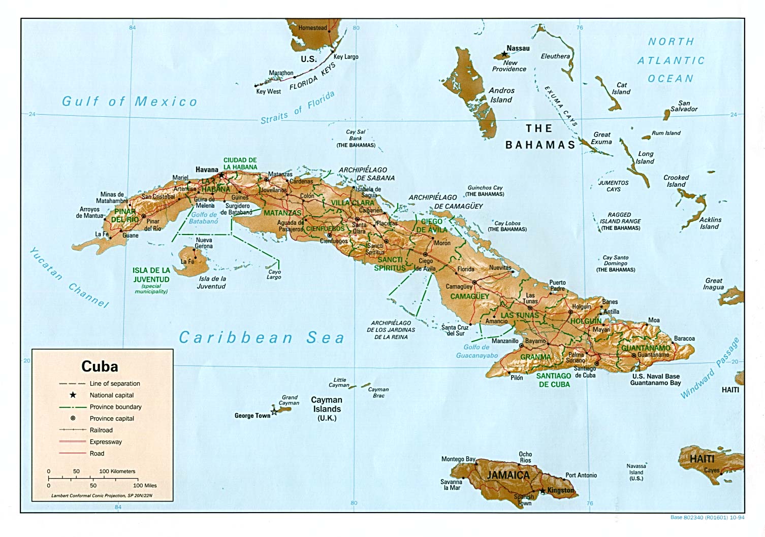
Anyone has a graphic or a map of the topografy of Cuba? I know that in the eastern part,there are very high mountains,but in the central part of Cuba the mountains are not very high.And the center is reaching central Cuba.
0 likes   

User avatar
HURAKAN
Professional-Met
Professional-Met
Posts: 46086
Age: 38
Joined: Thu May 20, 2004 4:34 pm
Location: Key West, FL
Contact:

#1804 Postby HURAKAN » Tue Oct 30, 2007 5:33 am

Image

Central Cuba is a plain, not mountanous.
0 likes   

User avatar
wxman57
Moderator-Pro Met
Moderator-Pro Met
Posts: 22979
Age: 67
Joined: Sat Jun 21, 2003 8:06 pm
Location: Houston, TX (southwest)

Re:

#1805 Postby wxman57 » Tue Oct 30, 2007 5:35 am

AJC3 wrote:It's pretty clear to see on the 00Z 500MB analysis charts. There's a weak H50 short wave trough over the lower MS valley.

http://www.rap.ucar.edu/weather/upper/upaRAOB_500.gif

This will get kicked eastward over the next couple days as a much stronger short wave trough deepens upstream. This is forecast by all the global models to erode the western portion of the Atlantic ridge by 36 hours. If there was H50 forecast charts with 10M contours, it would make it much easier to see.


How about a 500mb chart with 5 meter contours? I added in 500mb winds for good measure. Noel will be running into a different upper-level wind pattern as it approaches Andros Island, which should result in a slowing in forward wind speed followed by a turn to the north. Fairly similar to Floyd in 1999 as far as the confidence in the turn. But this time, the center won't head north to the Carolinas.

Image

By the way, Noel is right on track. Check out my forecast track from 17Z yesterday:
Image
0 likes   

User avatar
Evil Jeremy
S2K Supporter
S2K Supporter
Posts: 5463
Age: 32
Joined: Mon Apr 10, 2006 2:10 pm
Location: Los Angeles, CA

#1806 Postby Evil Jeremy » Tue Oct 30, 2007 5:35 am

What does this mean for Florida? It is already following the southernmost part of the 5AM cone, and it is possibly further south than what the cone said is possible.
0 likes   

User avatar
HURAKAN
Professional-Met
Professional-Met
Posts: 46086
Age: 38
Joined: Thu May 20, 2004 4:34 pm
Location: Key West, FL
Contact:

#1807 Postby HURAKAN » Tue Oct 30, 2007 5:37 am

Image
0 likes   

User avatar
cycloneye
Admin
Admin
Posts: 145354
Age: 68
Joined: Thu Oct 10, 2002 10:54 am
Location: San Juan, Puerto Rico

Re: Tropical Storm NOEL : Discussions & Images

#1808 Postby cycloneye » Tue Oct 30, 2007 5:42 am

:uarrow: It has passed the tallest mountains.
0 likes   

caneman

Re: Re:

#1809 Postby caneman » Tue Oct 30, 2007 5:42 am

wxman57 wrote:
AJC3 wrote:It's pretty clear to see on the 00Z 500MB analysis charts. There's a weak H50 short wave trough over the lower MS valley.

http://www.rap.ucar.edu/weather/upper/upaRAOB_500.gif

This will get kicked eastward over the next couple days as a much stronger short wave trough deepens upstream. This is forecast by all the global models to erode the western portion of the Atlantic ridge by 36 hours. If there was H50 forecast charts with 10M contours, it would make it much easier to see.


How about a 500mb chart with 5 meter contours? I added in 500mb winds for good measure. Noel will be running into a different upper-level wind pattern as it approaches Andros Island, which should result in a slowing in forward wind speed followed by a turn to the north. Fairly similar to Floyd in 1999 as far as the confidence in the turn. But this time, the center won't head north to the Carolinas.

Image

By the way, Noel is right on track. Check out my forecast track from 17Z yesterday:
Image


I would disagree. Noel looks West and just South of your plot. Further, Noel looks to moving quite a bit faster and is more South and West of NHC 5:00 plots. Looks like it has moved SW and inland which wasn't part of yours or NHC's forecastNot saying this will affect the eventual path but you can't deny current obs like that radar shot.
Last edited by caneman on Tue Oct 30, 2007 5:48 am, edited 1 time in total.
0 likes   

User avatar
Evil Jeremy
S2K Supporter
S2K Supporter
Posts: 5463
Age: 32
Joined: Mon Apr 10, 2006 2:10 pm
Location: Los Angeles, CA

#1810 Postby Evil Jeremy » Tue Oct 30, 2007 5:46 am

Quote from South Florida's latest Hazardous Weather Outlook:

IT IS IMPORTANT TO UNDERSTAND THAT THE FORECAST WINDS ARE
THEREFORE NOT ASSOCIATED WITH THE INNER CIRCULATION OF NOEL BUT
RATHER WITH THE LARGE SCALE PRESSURE GRADIENT BETWEEN NOEL AND A
HIGH PRESSURE SYSTEM ACROSS THE SOUTHEAST. THEREFORE...A WIND
ADVISORY...AND NOT A TROPICAL STORM WATCH...IS NOW IN EFFECT
BECAUSE THE STRONG WINDS WILL BEGIN TO BE FELT ACROSS THE AREA
TODAY WELL IN ADVANCED AND AWAY FROM THE STORM. HOWEVER...GIVEN
THE UNCERTAINTY IN THE FORECAST TRACK...THIS ADVISORY COULD BE
UPGRADED TO A TROPICAL STORM WATCH OR WARNING LATER TODAY IF THE
FORECAST TRACK BEGINS TO SHIFT TOWARDS THE WEST PLACING SOUTHEAST
FLORIDA WITHIN THE INNER CIRCULATION OF NOEL.
0 likes   

User avatar
cycloneye
Admin
Admin
Posts: 145354
Age: 68
Joined: Thu Oct 10, 2002 10:54 am
Location: San Juan, Puerto Rico

Re: Tropical Storm NOEL : Discussions & Images

#1811 Postby cycloneye » Tue Oct 30, 2007 5:53 am

Image

It looks like is inside Cuba now.The tallest mountains are well SE of the center.
0 likes   

User avatar
Evil Jeremy
S2K Supporter
S2K Supporter
Posts: 5463
Age: 32
Joined: Mon Apr 10, 2006 2:10 pm
Location: Los Angeles, CA

#1812 Postby Evil Jeremy » Tue Oct 30, 2007 5:55 am

It looks very organized, but the amount of time it spends over Cuba is going to be crucial for Florida.
0 likes   

User avatar
Thunder44
Category 5
Category 5
Posts: 5922
Age: 44
Joined: Mon Jun 09, 2003 7:53 pm
Location: New York City

Re: Tropical Storm NOEL : Discussions & Images

#1813 Postby Thunder44 » Tue Oct 30, 2007 6:03 am

It definitely looks inland now in Cuba (as of 5:15am EDT), according to radar. But the 6z GFS has it inland over Central Cuba at this time too:

http://www.nco.ncep.noaa.gov/pmb/nwprod ... n_006l.gif

It also looks like a partial eyewall is forming north of the center.
0 likes   

User avatar
cycloneye
Admin
Admin
Posts: 145354
Age: 68
Joined: Thu Oct 10, 2002 10:54 am
Location: San Juan, Puerto Rico

Re: Tropical Storm NOEL : Discussions & Images

#1814 Postby cycloneye » Tue Oct 30, 2007 6:06 am

The radar has to be refreshed.I have the image up to 5:45 AM EDT.
0 likes   

User avatar
HURAKAN
Professional-Met
Professional-Met
Posts: 46086
Age: 38
Joined: Thu May 20, 2004 4:34 pm
Location: Key West, FL
Contact:

#1815 Postby HURAKAN » Tue Oct 30, 2007 6:09 am

Image
0 likes   

User avatar
Thunder44
Category 5
Category 5
Posts: 5922
Age: 44
Joined: Mon Jun 09, 2003 7:53 pm
Location: New York City

Re: Tropical Storm NOEL : Discussions & Images

#1816 Postby Thunder44 » Tue Oct 30, 2007 6:10 am

According to radar, the center is now running south of the NHC track. It looks like it heading more west than WNW. They keep it off Cuba for the next 12hrs:

http://www.nhc.noaa.gov/refresh/graphic ... y#contents
0 likes   

User avatar
stormchazer
Category 5
Category 5
Posts: 2461
Joined: Fri Aug 29, 2003 12:00 pm
Location: Lakeland, Florida
Contact:

#1817 Postby stormchazer » Tue Oct 30, 2007 6:12 am

Interesting watching Noel as it appears to be tracking generally westward over Cuba. Will this keep Noel weaker and possible change the steering flow it follows allowing it to get further west, albeit weaker? Someone smarter then me might could answer, is it possible that Noel may split with the MLC moving in line with the models and the LLC traveling on into the Carribean?

Very interesting.
0 likes   

tgenius
S2K Supporter
S2K Supporter
Posts: 1160
Joined: Mon May 15, 2006 5:31 pm
Location: Miami, FL

Re: Tropical Storm NOEL : Discussions & Images

#1818 Postby tgenius » Tue Oct 30, 2007 6:24 am

I really don't want this storm to drop rain tommorow, it's halloween! My wife and I are getting dressed up too. :grrr:
0 likes   

User avatar
HURAKAN
Professional-Met
Professional-Met
Posts: 46086
Age: 38
Joined: Thu May 20, 2004 4:34 pm
Location: Key West, FL
Contact:

#1819 Postby HURAKAN » Tue Oct 30, 2007 6:29 am

HOLLOWEEN SELECTIONS FOR SE FLORIDA:

Image

Image

Image

Image
0 likes   

User avatar
cycloneye
Admin
Admin
Posts: 145354
Age: 68
Joined: Thu Oct 10, 2002 10:54 am
Location: San Juan, Puerto Rico

Re: Tropical Storm NOEL : Discussions & Images

#1820 Postby cycloneye » Tue Oct 30, 2007 6:33 am

Image

Image
0 likes   


Return to “2007”

Who is online

Users browsing this forum: No registered users and 10 guests