Hurricane NOEL : Discussions & Images

Moderator: S2k Moderators

Message
Author
tolakram
Admin
Admin
Posts: 20009
Age: 62
Joined: Sun Aug 27, 2006 8:23 pm
Location: Florence, KY (name is Mark)

Re: Tropical Storm NOEL : Discussions & Images

#2001 Postby tolakram » Tue Oct 30, 2007 12:15 pm

MiamiensisWx wrote:Okay... I can clearly see a low-level circulation off northern Cuba (beneath the MLC and convection).

http://rammb.cira.colostate.edu/ramsdis/online/loop_640.asp?product=tropical_ge_1km_center_relative_vis_floater

"The center follows the convection."


Where? Slow it down. It's an illusion that the low level clouds are moving west near the mlc. That LLC appears to be quite vigorous, but again I could be dead wrong. :) I'm looking for low level clouds moving west and I can't see any.
0 likes   

User avatar
Bgator
Category 2
Category 2
Posts: 649
Joined: Mon Sep 05, 2005 12:29 pm
Location: Orlando, FL

Re: Tropical Storm NOEL : Discussions & Images

#2002 Postby Bgator » Tue Oct 30, 2007 12:16 pm

Can some one put a picture up where they think the new llc is...I see the overall rotation but its hard to pinpoint.
I would say 21.9 76.8..about right?
You can see the original LLC quite well now, starting to head a bit more on a 285 direction...Still looks like its doesnt want to die out.
0 likes   

User avatar
Thunder44
Category 5
Category 5
Posts: 5922
Age: 44
Joined: Mon Jun 09, 2003 7:53 pm
Location: New York City

Re: Tropical Storm NOEL : Discussions & Images

#2003 Postby Thunder44 » Tue Oct 30, 2007 12:18 pm

MiamiensisWx wrote:Okay... I can clearly see a low-level circulation off northern Cuba (beneath the MLC and convection).

http://rammb.cira.colostate.edu/ramsdis/online/loop_640.asp?product=tropical_ge_1km_center_relative_vis_floater

"The center follows the convection."


I've been look at the loop closely the last few mins. I see the low-level cloud elements heading from SE to NW under the MLC. I still see only one LLC over inland Cuba.
0 likes   

User avatar
ronjon
Category 5
Category 5
Posts: 4822
Joined: Fri Aug 19, 2005 5:17 pm
Location: Hernando Beach, FL

Re: Tropical Storm NOEL : Discussions & Images

#2004 Postby ronjon » Tue Oct 30, 2007 12:20 pm

Judging by the latest 12Z UKMET, GFS, NAM, and CMC - all the models take the center into central Cuba near 80W in 24 hrs and then slowly move it N-NE over the next 24 hrs. Since the northern semi-circle of the storm will contain the highest winds and heaviest rain - and the storm will be approaching S FL from the south, I would suspect the upper keys and SE coast is going to see some heavy rain and squalls from this one. Based on these models, I would bet that NHC will hoist a TS watch at the 5 PM update from Jupiter Inlet to Long Key.
0 likes   

MiamiensisWx

Re: Tropical Storm NOEL : Discussions & Images

#2005 Postby MiamiensisWx » Tue Oct 30, 2007 12:20 pm

tolakram wrote:Where? Slow it down. It's an illusion that the low level clouds are moving west near the mlc. That LLC appears to be quite vigorous, but again I could be dead wrong. :) I'm looking for low level clouds moving west and I can't see any.

http://www.ssd.noaa.gov/goes/flt/t1/loop-vis.html

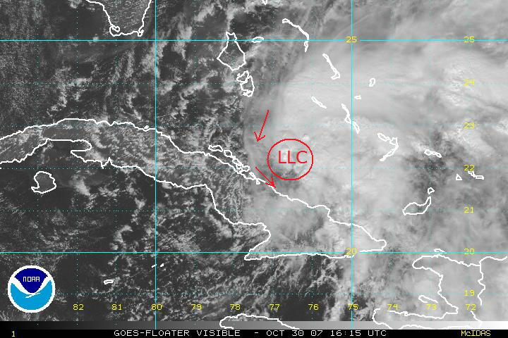
Click on latitude and longitude. You can see low-level cloud motion just west of 22.1N and 76.7W (which is the LLC's location under the MLC).

LLC's location and turning motion can be shown on this image.

Image
0 likes   

User avatar
cycloneye
Admin
Admin
Posts: 145313
Age: 68
Joined: Thu Oct 10, 2002 10:54 am
Location: San Juan, Puerto Rico

Re: Tropical Storm NOEL : Discussions & Images

#2006 Postby cycloneye » Tue Oct 30, 2007 12:21 pm

Image
0 likes   

MiamiensisWx

Re: Tropical Storm NOEL : Discussions & Images

#2007 Postby MiamiensisWx » Tue Oct 30, 2007 12:24 pm

Bgator wrote:Can some one put a picture up where they think the new llc is...I see the overall rotation but its hard to pinpoint.
I would say 21.9 76.8..about right?
You can see the original LLC quite well now, starting to head a bit more on a 285 direction...Still looks like its doesnt want to die out.

http://i24.photobucket.com/albums/c18/CapeVerdeWave/NoelOct30072.png
0 likes   

NcentralFlaguy
Tropical Storm
Tropical Storm
Posts: 136
Joined: Sun Jun 17, 2007 9:36 am

#2008 Postby NcentralFlaguy » Tue Oct 30, 2007 12:24 pm

Either way i think the forecast will be challenging, if it reforms under the mlc it will wind up 12 or more hours ahead of the forecast positions. that would probably precipitate some type of change in thinking. maybe only slightly though, if it moves into the NW carib than????? who knows.
0 likes   

tolakram
Admin
Admin
Posts: 20009
Age: 62
Joined: Sun Aug 27, 2006 8:23 pm
Location: Florence, KY (name is Mark)

Re: Tropical Storm NOEL : Discussions & Images

#2009 Postby tolakram » Tue Oct 30, 2007 12:25 pm

Click on latitude and longitude. You can see low-level cloud motion just west of 22.1N and 76.7W (which is the LLC's location under the MLC).


I was assuming that was the MLC. Looking at cloud motion in the holes around that image I still see motion around the llc over Cuba. /shrug It will be interesting to see what happens. If you're right then I've learned something today.
0 likes   

User avatar
Bgator
Category 2
Category 2
Posts: 649
Joined: Mon Sep 05, 2005 12:29 pm
Location: Orlando, FL

Re: Tropical Storm NOEL : Discussions & Images

#2010 Postby Bgator » Tue Oct 30, 2007 12:28 pm

Image

This is what I see, personally. Look ok?
0 likes   

BobHarlem
Category 5
Category 5
Posts: 2108
Joined: Thu Oct 20, 2005 6:11 pm

Re: Tropical Storm NOEL : Discussions & Images

#2011 Postby BobHarlem » Tue Oct 30, 2007 12:30 pm

tolakram wrote:
Click on latitude and longitude. You can see low-level cloud motion just west of 22.1N and 76.7W (which is the LLC's location under the MLC).


I was assuming that was the MLC. Looking at cloud motion in the holes around that image I still see motion around the llc over Cuba. /shrug It will be interesting to see what happens. If you're right then I've learned something today.


The LLC is still most definitely over Cuba, and heading generally west, that graphic has where the mid level might be, though.
0 likes   

User avatar
Thunder44
Category 5
Category 5
Posts: 5922
Age: 44
Joined: Mon Jun 09, 2003 7:53 pm
Location: New York City

Re: Tropical Storm NOEL : Discussions & Images

#2012 Postby Thunder44 » Tue Oct 30, 2007 12:34 pm

Surface obs at the top of the hour still support the "old" LLC over inland Cuba. It's also well defined in visible imagery now. I've notice the MLC become has better defined and vigourous over the past hour or so, so it may start working down to the surface soon.
0 likes   

NcentralFlaguy
Tropical Storm
Tropical Storm
Posts: 136
Joined: Sun Jun 17, 2007 9:36 am

Re: Tropical Storm NOEL : Discussions & Images

#2013 Postby NcentralFlaguy » Tue Oct 30, 2007 12:35 pm

well the LBAR has it striking florida from the ssw ,so we can effectively rule that scenario out! :lol:
0 likes   

User avatar
Canelaw99
S2K Supporter
S2K Supporter
Posts: 2127
Age: 48
Joined: Tue Aug 31, 2004 8:27 am
Location: Homestead, FL

Re: Tropical Storm NOEL : Discussions & Images

#2014 Postby Canelaw99 » Tue Oct 30, 2007 12:36 pm

NcentralFlaguy wrote:well the LBAR has it striking florida from the ssw ,so we can effectively rule that scenario out! :lol:


LOL - normally, I'd agree with you, but Noel seems to be behaving the way he wants so I don't think anything can be totally ruled out :ggreen:
0 likes   

MiamiensisWx

Re: Tropical Storm NOEL : Discussions & Images

#2015 Postby MiamiensisWx » Tue Oct 30, 2007 12:38 pm

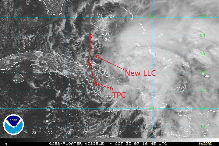
Okay... let's assume that my position for the new LLC (22.1N and 76.9W) is correct. That would be under the MLC. Currently, the MLC is moving quickly WNW-NW per satellite imagery (I'll estimate ~13 mph). If (emphasis added) that trend continues, the MLC (possible LLC) would be on the south side of the TPC's current cone, thus slightly increasing the risk to SE Florida. There are numerous uncertainties, and anything is possible per tolakram and Vortex. Thunder44 noted that the MLC is becoming more vigorous, thus supporting the possibility of a new LLC forming at the surface (per wxman57).

Image

http://www.ssd.noaa.gov/goes/flt/t1/loop-vis.html
0 likes   

curtadams
S2K Supporter
S2K Supporter
Posts: 1122
Joined: Sun Aug 28, 2005 7:57 pm
Location: Orange, California
Contact:

Re: Tropical Storm NOEL : Discussions & Images

#2016 Postby curtadams » Tue Oct 30, 2007 12:46 pm

MiamiensisWx wrote:Okay... I can clearly see a low-level circulation off northern Cuba (beneath the MLC and convection).

http://rammb.cira.colostate.edu/ramsdis/online/loop_640.asp?product=tropical_ge_1km_center_relative_vis_floater

I don't agree with your interpretation. In between the two centers, I see some clouds heading SE and some heading NW. The only interpretation I can make is that the SE clouds are going around the MLC and the NW clouds around the LLC. The LLC's circulation is too nice and circular for there to be another LLC lurking under the MLC. In addition, the two centers are obviously moving together so they are still coupled, distance notwithstanding.
0 likes   

CrazyC83
Professional-Met
Professional-Met
Posts: 34002
Joined: Tue Mar 07, 2006 11:57 pm
Location: Deep South, for the first time!

Re: Tropical Storm NOEL : Discussions & Images

#2017 Postby CrazyC83 » Tue Oct 30, 2007 12:47 pm

MiamiensisWx wrote:Okay... let's assume that my position for the new LLC (22.1N and 76.9W) is correct. That would be under the MLC. Currently, the MLC is moving quickly WNW-NW per satellite imagery (I'll estimate ~13 mph). If (emphasis added) that trend continues, the MLC (possible LLC) would be on the south side of the TPC's current cone, thus slightly increasing the risk to SE Florida. There are numerous uncertainties, and anything is possible per tolakram and Vortex. Thunder44 noted that the MLC is becoming more vigorous, thus supporting the possibility of a new LLC forming at the surface (per wxman57).

Image

http://www.ssd.noaa.gov/goes/flt/t1/loop-vis.html


That looks like an eye trying to form in the old MLC...
0 likes   

User avatar
gatorcane
S2K Supporter
S2K Supporter
Posts: 23691
Age: 47
Joined: Sun Mar 13, 2005 3:54 pm
Location: Boca Raton, FL

Re: Tropical Storm NOEL : Discussions & Images

#2018 Postby gatorcane » Tue Oct 30, 2007 12:47 pm

looks like alot of rain and wind is heading towards SE Florida...the new center appear to be forming just off the coast of Cuba heading WNW...and trying to get better organized.

South Florida needs to be vigilant on this one....this thing seems to be making a beeline towards the WNW this afternoon.

Where is the turn? Where is the turn?
Last edited by gatorcane on Tue Oct 30, 2007 12:50 pm, edited 1 time in total.
0 likes   

User avatar
SouthFLTropics
Category 5
Category 5
Posts: 4236
Age: 50
Joined: Thu Aug 14, 2003 8:04 am
Location: Port St. Lucie, Florida

Re: Tropical Storm NOEL : Discussions & Images

#2019 Postby SouthFLTropics » Tue Oct 30, 2007 12:49 pm

If this uncertainty continues I think it would only be prudent for the NHC to raise TS watches for SE Florida. Even if we don't get hit I think they should play it safe. Heck, we are getting close to TS winds now as it is with the pressure gradient. I know that when watches are issued it sets certain wheels in local and state government in motion but I think they would rather do it than not and have to relive 99's Irene scenario all over again. I remember that distinctly and after the fact everyone kept saying they didn't have any warning, etc.

SFT
0 likes   

User avatar
gatorcane
S2K Supporter
S2K Supporter
Posts: 23691
Age: 47
Joined: Sun Mar 13, 2005 3:54 pm
Location: Boca Raton, FL

Re: Tropical Storm NOEL : Discussions & Images

#2020 Postby gatorcane » Tue Oct 30, 2007 12:52 pm

SouthFLTropics wrote:If this uncertainty continues I think it would only be prudent for the NHC to raise TS watches for SE Florida. Even if we don't get hit I think they should play it safe. Heck, we are getting close to TS winds now as it is with the pressure gradient. I know that when watches are issued it sets certain wheels in local and state government in motion but I think they would rather do it than not and have to relive 99's Irene scenario all over again. I remember that distinctly and after the fact everyone kept saying they didn't have any warning, etc.

SFT


agreed TS watches and even Hurricane watches may need to be issues. Better play it safe in my opinion.

Winds are near TS gusts in Miami at this hour:

Pressure falling across all SE Florida locations......

W PALM BEACH LGT RAIN 81 71 71 E22G31 30.02F
FT LAUDER-EXEC MOSUNNY 84 68 58 NE25G32 29.98F
FT LAUDERDALE MOSUNNY 85 69 58 NE25G33 29.97F
POMPANO BEACH MOSUNNY 83 68 60 E23G36 29.99F
PEMBROKE PINES MOSUNNY 83 71 67 NE25G32 30.00F
OPA LOCKA MOSUNNY 84 70 62 NE22G32 29.98F
MIAMI PTSUNNY 84 69 60 NE22G29 29.98F
MIAMI BEACH N/A 82 72 69 NE29G38 29.98F
WEST KENDALL MOSUNNY 85 68 56 NE25G32 29.96F
HOMESTEAD MOSUNNY 84 73 68 NE23G32 29.96F
Last edited by gatorcane on Tue Oct 30, 2007 12:53 pm, edited 1 time in total.
0 likes   


Return to “2007”

Who is online

Users browsing this forum: No registered users and 4 guests