At ease, Gatorcane - the way I look at it, even if the weather did get a bit worse than forecast, that would keep the Chilloween nonsense down to a minimum (at least in this area), so...
I'll always recall looking east on a very special Sunday afternoon, and seeing the cirrus shield for Hurricane Andrew, when it was almost a Cat 5 over the Bahamas - and heading directly this way - now that was something to quiver over, because we all knew in some way that a certain part of our lives was about to end and/or change...
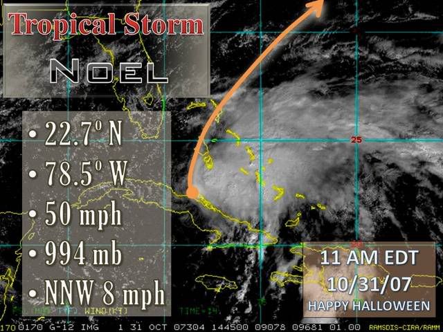
Hurricane NOEL : Discussions & Images
Moderator: S2k Moderators
Re: Tropical Storm NOEL : Discussions & Images
Last edited by Frank2 on Wed Oct 31, 2007 10:17 am, edited 3 times in total.
0 likes
-
Evil Jeremy

- S2K Supporter

- Posts: 5463
- Age: 32
- Joined: Mon Apr 10, 2006 2:10 pm
- Location: Los Angeles, CA
Re:
HURAKAN wrote:Latest:

The center is very orginized, but exposed. Still, now we will be able to track it better.
0 likes
-
Tropics Guy

- Tropical Storm

- Posts: 167
- Age: 63
- Joined: Tue Aug 31, 2004 8:12 pm
- Location: Hallandale beach & Vero beach, FL
Re: Tropical Storm NOEL : Discussions & Images
Wow, Noel would have to almost start going due north from here to make the forecast points, looking at the visibles there is still obviously some westward momentum continuing.
http://www.ssd.noaa.gov/goes/flt/t1/loop-vis.html
http://www.ssd.noaa.gov/goes/flt/t1/loop-vis.html
0 likes
-
Blown Away

- S2K Supporter
- Posts: 10253
- Joined: Wed May 26, 2004 6:17 am
Re: Tropical Storm NOEL : Discussions & Images
I don't know anything about anything about weather. Looking at the visible and turning on the "Tropical Forecast Points", specifically the point just N of Cuba, I see what appears to be the LLC moving WNW, if that is the LLC it is not moving NNW at this point, IMO.
http://www.ssd.noaa.gov/goes/flt/t1/loop-vis.html
http://www.ssd.noaa.gov/goes/flt/t1/loop-vis.html
0 likes
-
DESTRUCTION5

- Category 5

- Posts: 4430
- Age: 44
- Joined: Wed Sep 03, 2003 11:25 am
- Location: Stuart, FL
Re: Tropical Storm NOEL : Discussions & Images
Blown_away wrote:I don't know anything about anything about weather. Looking at the visible and turning on the "Tropical Forecast Points", specifically the point just N of Cuba, I see what appears to be the LLC moving WNW, if that is the LLC it is not moving NNW at this point, IMO.
http://www.ssd.noaa.gov/goes/flt/t1/loop-vis.html
umm This should not really be a surprise..
GFS has been calling this for mutiple runs now..But from what I hear its not worh the paper its written on..
http://www.nco.ncep.noaa.gov/pmb/nwprod ... loop.shtml
0 likes
Re: Tropical Storm NOEL : Discussions & Images
Blown_away wrote:I don't know anything about anything about weather. Looking at the visible and turning on the "Tropical Forecast Points", specifically the point just N of Cuba, I see what appears to be the LLC moving WNW, if that is the LLC it is not moving NNW at this point, IMO.
http://www.ssd.noaa.gov/goes/flt/t1/loop-vis.html
i don't know but i'd like someone to explain to me how the recon fix between 9 am 22.5 78.13
and 11 am 22.4 78.36 is WSW!!!!
0 likes

Dewpoint across SFL have shot up this morning to the low-mid 70's..
South Florida Hourly Weather Roundup 1000 AM EDT WED OCT 31 2007
City Sky & Wx Tmp DP RH Wind Pres Remarks
NAPLES PTSUNNY 79 72 79 NE12G21 29.90R
W PALM BEACH PTSUNNY 80 73 79 E23G32 29.92R
FT LAUDER-EXEC PTSUNNY 81 70 69 NE23G38 29.88R
FT LAUDERDALE LGT RAIN 81 72 74 NE25G37 29.86R
POMPANO BEACH PTSUNNY 81 71 71 E21G33 29.88R
PEMBROKE PINES MOSUNNY 80 72 76 NE29G36 29.90R
OPA LOCKA CLOUDY 80 73 79 NE17G28 29.87R
MIAMI PTSUNNY 80 73 79 NE17G30 29.86S
MIAMI BEACH N/A 79 76 89 E30G41 29.83R
WEST KENDALL LGT RAIN 77 73 88 NE12 29.85F
HOMESTEAD PTSUNNY 80 75 85 NE21G26 29.85R
0 likes
-
HenkL
- S2K Supporter
- Posts: 2401
- Joined: Fri Sep 10, 2004 5:33 pm
- Location: Groningen, The Netherlands
- Contact:
URNT15 KNHC 311522
AF302 0816A NOEL HDOB 25 20071031
151000 2244N 07634W 9243 00737 0057 +197 +197 155047 048 041 010 03
151030 2245N 07634W 9250 00731 0064 +181 +181 149043 045 999 999 03
151100 2246N 07636W 9254 00723 0066 +171 +171 145036 038 046 019 03
151130 2247N 07638W 9238 00740 0062 +181 +181 144036 036 034 010 03
151200 2249N 07638W 9248 00731 0056 +203 +199 148034 037 049 020 00
151230 2250N 07639W 9235 00743 0058 +201 +183 149039 042 052 025 03
151300 2252N 07640W 9243 00736 0060 +193 +182 153048 049 048 013 00
151330 2254N 07641W 9241 00737 0065 +180 +180 148047 050 047 015 00
151400 2256N 07642W 9246 00736 0066 +183 +183 140045 047 046 025 00
151430 2258N 07642W 9242 00740 0068 +178 +178 135045 046 043 020 00
151500 2259N 07643W 9248 00733 0070 +169 +169 134041 045 050 024 00
151530 2301N 07644W 9239 00743 0070 +171 +171 139039 040 048 018 00
151600 2303N 07645W 9250 00730 0068 +172 +172 139038 040 049 020 00
151630 2305N 07645W 9240 00740 0069 +169 +169 134038 039 050 025 00
151700 2306N 07646W 9247 00734 0070 +167 +167 138037 039 054 028 00
151730 2308N 07647W 9224 00757 0069 +175 +175 136038 039 051 023 00
151800 2310N 07648W 9238 00739 0068 +174 +174 139042 050 048 015 00
151830 2312N 07648W 9256 00730 0071 +177 +177 133035 039 042 012 00
151900 2313N 07649W 9240 00744 0067 +192 +192 138033 034 040 009 00
151930 2315N 07650W 9224 00759 0071 +178 +178 124036 040 042 017 00
0 likes


Re: Tropical Storm NOEL : Discussions & Images
Is the low level center running away from the convection or is it just dislocated as it was most of last night and this morning?
0 likes
Re: Tropical Storm NOEL : Discussions & Images
yes it is noticeably more HUMID this morning than last evening, man i gotta get off this computer and check on the erosion, this board is addicting at times like these.
0 likes
-
Sal Collaziano
- Tropical Depression

- Posts: 61
- Age: 54
- Joined: Sun Oct 30, 2005 8:53 pm
- Location: Wellington, Florida, USA
- Contact:
-
feederband

- S2K Supporter
- Posts: 3423
- Joined: Wed Oct 01, 2003 6:21 pm
- Location: Lakeland Fl
Re: Tropical Storm NOEL : Discussions & Images
ExBailbonds wrote:ExBailbonds wrote:Frank2 wrote:Yes, unlikely that the NHC will post any watches for Florida - the system seems to be tracking due north (and eventually northeast), so, any affect here (other than the gradient wind) should be minimal...
Sorry, folks...
I feel the same but we abought to find out so i hope we dont have to eat crow. but i am rather confident we wont have a feathered diner.
Well no crow for the moment anyway.

0 likes
-
Blown Away
- S2K Supporter
- Posts: 10253
- Joined: Wed May 26, 2004 6:17 am
Re: Tropical Storm NOEL : Discussions & Images
DESTRUCTION5 wrote:Blown_away wrote:I don't know anything about anything about weather. Looking at the visible and turning on the "Tropical Forecast Points", specifically the point just N of Cuba, I see what appears to be the LLC moving WNW, if that is the LLC it is not moving NNW at this point, IMO.
http://www.ssd.noaa.gov/goes/flt/t1/loop-vis.html
umm This should not really be a surprise..
GFS has been calling this for mutiple runs now..But from what I hear its not worh the paper its written on..
http://www.nco.ncep.noaa.gov/pmb/nwprod ... loop.shtml
Noel is getting better organized and is at 78.5W and we are being told it's moving NNW and it's obvious that it is moving WNW. Every degree W matters at this point.
0 likes

-
Derek Ortt
-
DESTRUCTION5
- Category 5
- Posts: 4430
- Age: 44
- Joined: Wed Sep 03, 2003 11:25 am
- Location: Stuart, FL
Re:
Derek Ortt wrote:some are so desperate for a storm that they are excited about an exposed center moving away from the deep convection
That said, this storm is driving me as insane as this Pagan ritual that many observe today
Sorry but I have to LMAO at that one Ortt..
0 likes
-
Evil Jeremy
- S2K Supporter
- Posts: 5463
- Age: 32
- Joined: Mon Apr 10, 2006 2:10 pm
- Location: Los Angeles, CA
Re: Tropical Storm NOEL : Discussions & Images
DESTRUCTION5 wrote:Blown_away wrote:I don't know anything about anything about weather. Looking at the visible and turning on the "Tropical Forecast Points", specifically the point just N of Cuba, I see what appears to be the LLC moving WNW, if that is the LLC it is not moving NNW at this point, IMO.
http://www.ssd.noaa.gov/goes/flt/t1/loop-vis.html
umm This should not really be a surprise..
GFS has been calling this for mutiple runs now..But from what I hear its not worh the paper its written on..
http://www.nco.ncep.noaa.gov/pmb/nwprod ... loop.shtml
I dont know where you heard that from. The GFS is amazing when it comes to track, but bad at intensity. When Dennis was out there in the Caribbean as a Catagory 5 Hurricane, the GFS kept on initializing it as a Tropical Depression, but it had the track spot on.
I am getting worried. Higher than expected dew points, obvious WNW movement, and its distance to South Florida is begining to worry me.
0 likes
Re:
Derek Ortt wrote:some are so desperate for a storm that they are excited about an exposed center moving away from the deep convection
That said, this storm is driving me as insane as this Pagan ritual that many observe today
Derek,
What a way to possibly close out the season
0 likes
Who is online
Users browsing this forum: No registered users and 51 guests