Hurricane NOEL : Discussions & Images

Moderator: S2k Moderators

Message
Author
User avatar
fci
S2K Supporter
S2K Supporter
Posts: 3324
Joined: Tue Sep 14, 2004 10:29 am
Location: Lake Worth, FL

Re: Tropical Storm NOEL : Discussions & Images

#2641 Postby fci » Wed Oct 31, 2007 10:48 am

gatorcane wrote:Looks like TS Warnings and hurricane warnings? may be needed for SE Florida......


OK, this post has to take the case as one of the most hysterical ones I have seen from you Chris.

Both in terms of how hysterically I laughted and the level of hysteria this has worked you up into.

I would bet anything you have that you will never see a Hurricane Warning from Noel.

Even if ALL OF THE EXPERTS are wrong and it gets real close to us; the associated weather is on the east side and this WILL NOT go west of us so it is a moot point anyway.

Thanks for the fun!
0 likes   

User avatar
Vortex
S2K Supporter
S2K Supporter
Posts: 4644
Age: 53
Joined: Fri Aug 01, 2003 9:34 pm
Location: Hilton Head, SC

Re: Re:

#2642 Postby Vortex » Wed Oct 31, 2007 10:49 am

DESTRUCTION5 wrote:
Vortex wrote:looks like it's making a run for the keys...


12Z looks realistic..Between bahamas and Fl Straits..

http://www.nco.ncep.noaa.gov/pmb/nwprod ... loop.shtml


AGREE..looks on the money based on current trends
0 likes   

cpdaman
Category 5
Category 5
Posts: 3131
Joined: Sat Jun 10, 2006 11:44 am
Location: SPB county (gulf stream)

#2643 Postby cpdaman » Wed Oct 31, 2007 10:50 am

which direction is the low level flow

just asking because i was wondering if this could hook back to the WSW like it appeared to 36 hours ago
0 likes   

Frank2
Category 5
Category 5
Posts: 4061
Joined: Mon Jul 25, 2005 12:47 pm

Re: Tropical Storm NOEL : Discussions & Images

#2644 Postby Frank2 » Wed Oct 31, 2007 10:50 am

If anyone has to be very concerned about Noel, it's those who live in Newfoundland...

http://www.weatheroffice.gc.ca/hurrican ... nts_e.html
Last edited by Frank2 on Wed Oct 31, 2007 10:52 am, edited 2 times in total.
0 likes   

User avatar
Vortex
S2K Supporter
S2K Supporter
Posts: 4644
Age: 53
Joined: Fri Aug 01, 2003 9:34 pm
Location: Hilton Head, SC

#2645 Postby Vortex » Wed Oct 31, 2007 10:51 am

Also,

11AM Dewpoints continue to climb and are now almost exclusively in the mid 70's with Miami Beach 76
0 likes   

cpdaman
Category 5
Category 5
Posts: 3131
Joined: Sat Jun 10, 2006 11:44 am
Location: SPB county (gulf stream)

Re: Tropical Storm NOEL : Discussions & Images

#2646 Postby cpdaman » Wed Oct 31, 2007 10:52 am

fci wrote:
gatorcane wrote:Looks like TS Warnings and hurricane warnings? may be needed for SE Florida......


OK, this post has to take the case as one of the most hysterical ones I have seen from you Chris.

Both in terms of how hysterically I laughted and the level of hysteria this has worked you up into.

I would bet anything you have that you will never see a Hurricane Warning from Noel.

Even if ALL OF THE EXPERTS are wrong and it gets real close to us; the associated weather is on the east side and this WILL NOT go west of us so it is a moot point anyway.

Thanks for the fun!


FCI those were my sentiments until i realized it could happen, although the chances are low
Last edited by cpdaman on Wed Oct 31, 2007 10:52 am, edited 1 time in total.
0 likes   

T'Bonz
Category 1
Category 1
Posts: 421
Joined: Wed Sep 01, 2004 5:23 pm
Location: Cary, North Carolina

Re: storm

#2647 Postby T'Bonz » Wed Oct 31, 2007 10:52 am

Derek Ortt wrote:some are so desperate for a storm that they are excited about an exposed center moving away from the deep convection


Ha, sez you. :D

I want it to go away. I have no time (or desire) for even a trop storm.

This storm has to be giving forecasters fits. Originally it was supposed to go north and then shoot off north east. Tracking shows that it surprised everyone and went west (and a bit south.) Now it seems to be heading back to where it was supposed to go originally. I think. :p

Will be interesting to see what it does next.
0 likes   

User avatar
Vortex
S2K Supporter
S2K Supporter
Posts: 4644
Age: 53
Joined: Fri Aug 01, 2003 9:34 pm
Location: Hilton Head, SC

#2648 Postby Vortex » Wed Oct 31, 2007 10:53 am

Interesting observation..The far outer bands of the circulation envelope reach as far west a cancun on vis imagery
0 likes   

User avatar
Vortex
S2K Supporter
S2K Supporter
Posts: 4644
Age: 53
Joined: Fri Aug 01, 2003 9:34 pm
Location: Hilton Head, SC

Re: storm

#2649 Postby Vortex » Wed Oct 31, 2007 10:54 am

T'Bonz wrote:
Derek Ortt wrote:some are so desperate for a storm that they are excited about an exposed center moving away from the deep convection


Ha, sez you. :D

I want it to go away. I have no time (or desire) for even a trop storm.

This storm has to be giving forecasters fits. Originally it was supposed to go north and then shoot off north east. Tracking shows that it surprised everyone and went west (and a bit south.) Now it seems to be heading back to where it was supposed to go originally. I think. :p

Will be interesting to see what it does next.


Hasn't this been the story this entire season???
0 likes   

User avatar
TampaFl
S2K Supporter
S2K Supporter
Posts: 1904
Age: 67
Joined: Thu Sep 04, 2003 11:23 am
Location: Tampa, FL

Re: Tropical Storm NOEL : Discussions & Images

#2650 Postby TampaFl » Wed Oct 31, 2007 10:54 am

Map courtesy of Boat USA.

Image
0 likes   

User avatar
HURAKAN
Professional-Met
Professional-Met
Posts: 46086
Age: 38
Joined: Thu May 20, 2004 4:34 pm
Location: Key West, FL
Contact:

#2651 Postby HURAKAN » Wed Oct 31, 2007 10:55 am

Image

At about 5 AM the center was close to Cayo Coco (Coconut Key).
0 likes   

HenkL
S2K Supporter
S2K Supporter
Posts: 2401
Joined: Fri Sep 10, 2004 5:33 pm
Location: Groningen, The Netherlands
Contact:

#2652 Postby HenkL » Wed Oct 31, 2007 10:55 am

URNT15 KNHC 311552
AF302 0816A NOEL HDOB 28 20071031
154000 2359N 07725W 9736 00291 0067 +219 +219 076036 037 041 003 00
154030 2358N 07727W 9737 00289 0066 +220 +220 077036 037 042 004 00
154100 2357N 07728W 9735 00290 0064 +220 +220 075036 038 042 003 00
154130 2355N 07729W 9734 00289 0062 +221 +221 078037 038 061 000 00
154200 2354N 07731W 9738 00283 0058 +224 +224 080037 037 103 011 03
154230 2353N 07732W 9733 00287 0058 +223 +223 079038 038 999 999 03
154300 2352N 07733W 9736 00283 0060 +204 +204 081039 040 139 006 03
154330 2350N 07735W 9737 00282 0059 +197 +197 083040 042 108 018 03
154400 2349N 07736W 9731 00287 0057 +216 +216 082040 041 999 999 03
154430 2348N 07738W 9733 00283 0056 +214 +214 085039 043 128 012 03
154500 2347N 07739W 9732 00285 0055 +215 +215 087041 042 999 999 03
154530 2345N 07740W 9736 00279 0054 +214 +214 091041 042 056 018 03
154600 2344N 07742W 9730 00286 0056 +202 +202 091034 037 999 999 03
154630 2343N 07743W 9733 00281 0056 +207 +207 105037 038 067 016 00
154700 2342N 07744W 9734 00282 0056 +196 +196 108039 040 043 012 00
154730 2341N 07746W 9734 00279 0053 +207 +207 107037 038 100 003 00
154800 2339N 07747W 9734 00278 0052 +208 +208 106037 038 039 006 00
154830 2338N 07748W 9738 00274 0049 +217 +217 106039 040 037 003 00
154900 2337N 07750W 9733 00276 0047 +221 +221 103038 039 036 003 00
154930 2336N 07751W 9734 00274 0045 +223 +220 100038 039 035 001 00

(edit)
Max SFMR wind: 100 kt
Although not marked as invalid, value is not reliable. Plane was flying above island.
Last edited by HenkL on Wed Oct 31, 2007 11:02 am, edited 2 times in total.
0 likes   

User avatar
Vortex
S2K Supporter
S2K Supporter
Posts: 4644
Age: 53
Joined: Fri Aug 01, 2003 9:34 pm
Location: Hilton Head, SC

Re: storm

#2653 Postby Vortex » Wed Oct 31, 2007 10:55 am

T'Bonz wrote:
Derek Ortt wrote:some are so desperate for a storm that they are excited about an exposed center moving away from the deep convection


Ha, sez you. :D

I want it to go away. I have no time (or desire) for even a trop storm.

This storm has to be giving forecasters fits. Originally it was supposed to go north and then shoot off north east. Tracking shows that it surprised everyone and went west (and a bit south.) Now it seems to be heading back to where it was supposed to go originally. I think. :p

Will be interesting to see what it does next.


FEMALE written all over it :lol: :lol:
0 likes   

tgenius
S2K Supporter
S2K Supporter
Posts: 1160
Joined: Mon May 15, 2006 5:31 pm
Location: Miami, FL

Re: Tropical Storm NOEL : Discussions & Images

#2654 Postby tgenius » Wed Oct 31, 2007 10:57 am

TampaFl wrote:Map courtesy of Boat USA.

Image


This wind map gives a good indication of just how far away Noel is from FL.. doesn't look like its that far
0 likes   

Derek Ortt

Re: Tropical Storm NOEL Recon Obs

#2655 Postby Derek Ortt » Wed Oct 31, 2007 10:59 am

do NOT use SFMR over land. It has a significant high bias
0 likes   

Frank2
Category 5
Category 5
Posts: 4061
Joined: Mon Jul 25, 2005 12:47 pm

Re: Tropical Storm NOEL : Discussions & Images

#2656 Postby Frank2 » Wed Oct 31, 2007 11:00 am

That's a good map (shows the circuitous route Noel has taken so far)...

It's pretty far from Florida - about the same distance as Miami from Gainesville...
0 likes   

HenkL
S2K Supporter
S2K Supporter
Posts: 2401
Joined: Fri Sep 10, 2004 5:33 pm
Location: Groningen, The Netherlands
Contact:

#2657 Postby HenkL » Wed Oct 31, 2007 11:01 am

Thanks, Derek. I noticed.
0 likes   

HenkL
S2K Supporter
S2K Supporter
Posts: 2401
Joined: Fri Sep 10, 2004 5:33 pm
Location: Groningen, The Netherlands
Contact:

#2658 Postby HenkL » Wed Oct 31, 2007 11:03 am

URNT15 KNHC 311602
AF302 0816A NOEL HDOB 29 20071031
155000 2335N 07752W 9734 00273 0044 +222 +222 094038 038 035 002 00
155030 2333N 07754W 9738 00271 0044 +215 +215 092035 037 037 001 00
155100 2332N 07755W 9733 00270 0042 +220 +220 092037 039 039 000 00
155130 2331N 07756W 9732 00272 0041 +213 +213 090040 040 039 003 00
155200 2330N 07758W 9735 00267 0041 +206 +206 087038 039 039 007 00
155230 2328N 07759W 9733 00269 0041 +200 +200 091037 038 041 007 00
155300 2327N 07800W 9735 00265 0039 +199 +199 098039 041 042 008 00
155330 2326N 07802W 9734 00266 0038 +198 +198 100038 039 043 014 00
155400 2325N 07803W 9735 00261 0035 +198 +198 097036 037 046 015 00
155430 2324N 07804W 9730 00266 0032 +217 +217 098037 038 040 004 00
155500 2322N 07806W 9732 00264 0031 +217 +217 096032 033 036 006 00
155530 2321N 07807W 9732 00263 0030 +225 +225 106032 034 035 004 00
155600 2320N 07808W 9735 00258 0028 +228 +228 108027 030 035 001 00
155630 2319N 07810W 9733 00260 0027 +221 +221 099024 024 034 004 00
155700 2318N 07811W 9733 00259 0028 +212 +212 095024 026 036 008 00
155730 2317N 07812W 9734 00259 0026 +219 +219 105020 021 034 007 00
155800 2315N 07813W 9737 00253 0026 +209 +209 110022 022 039 010 00
155830 2314N 07815W 9730 00259 0026 +207 +207 106021 023 042 010 00
155900 2313N 07816W 9737 00252 0024 +219 +219 113020 021 036 006 00
155930 2312N 07817W 9732 00257 0022 +230 +230 111018 021 033 005 00
0 likes   

User avatar
artist
Category 5
Category 5
Posts: 9792
Joined: Mon Jun 06, 2005 3:26 pm
Location: West Palm

Re: Tropical Storm NOEL : Discussions & Images

#2659 Postby artist » Wed Oct 31, 2007 11:04 am

fci wrote:[
OK, this post has to take the case as one of the most hysterical ones I have seen from you Chris.

Both in terms of how hysterically I laughted and the level of hysteria this has worked you up into.

I would bet anything you have that you will never see a Hurricane Warning from Noel.

Even if ALL OF THE EXPERTS are wrong and it gets real close to us; the associated weather is on the east side and this WILL NOT go west of us so it is a moot point anyway.

Thanks for the fun!
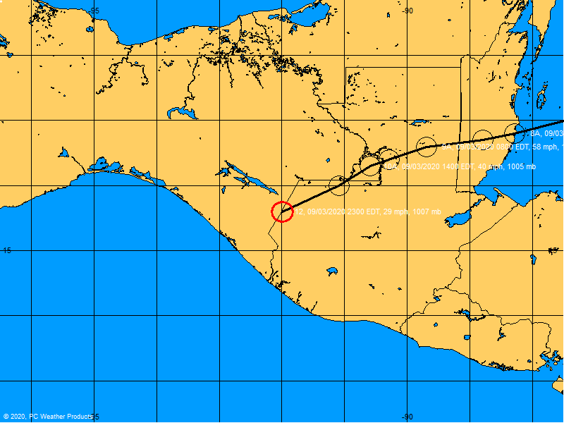
didn't recon find the strongest winds in the nw quad just awhile ago? I do not want a storm other than some rain, maybe. But for those, even the mets, that continue to say it will be nothing - did everyone forget what Charlie did? I am in no way suggesting I think it could pull a Charlie - I'm not, but even with a strong ts we could lose power and I want to be prepared and ready. When it is not following the direction of the NHC then I begin to really keep my eye on it - such as going further west than they had thought, the winds are in the nw quad, etc. There was already a power outage from the winds earlier this morning. These things can defy all odds sometimes and when they are this close to home I am going to keep my eye on them until they are gone. There may be a few with theatrics here but I think most of us just want to see it get past our lat/lon and then we will breathe easy.
0 likes   

Derek Ortt

#2660 Postby Derek Ortt » Wed Oct 31, 2007 11:09 am

storm has decoupled... mid level shear far to strong

also, the latest recon reports show a weakening trend may have begun as pressures are a little higher than previously
0 likes   


Return to “2007”

Who is online

Users browsing this forum: No registered users and 3 guests