Hurricane NOEL : Discussions & Images
Moderator: S2k Moderators
Re: Tropical Storm NOEL : Discussions & Images
I think its pretty fitting that what appears to be the last storm of the season (obviously still a month left) would give so many people fits. 
0 likes
-
gatorcane

- S2K Supporter

- Posts: 23708
- Age: 48
- Joined: Sun Mar 13, 2005 3:54 pm
- Location: Boca Raton, FL
Re:
Derek Ortt wrote:I am close to cluess regarding what this will do. The fact that the LLC keeps becoming exposed (thanks, mid level shear) is what is making this such a tricky forecast
lol i think this storm has got everybody baffled....
FYI some models predicting it would meander around cuba for a couple of days....
those cuban cigars must be good
0 likes


-
HenkL
- S2K Supporter
- Posts: 2401
- Joined: Fri Sep 10, 2004 5:33 pm
- Location: Groningen, The Netherlands
- Contact:
URNT15 KNHC 311902
AF302 0816A NOEL HDOB 47 20071031
185000 2425N 07924W 6317 03968 0039 +060 +020 053022 023 040 000 00
185030 2426N 07927W 6316 03972 0039 +060 +017 052023 023 039 000 00
185100 2427N 07930W 6317 03968 0046 +055 +018 052025 025 049 000 00
185130 2427N 07932W 6316 03971 0049 +053 +018 052026 027 041 001 00
185200 2428N 07935W 6317 03969 0046 +055 +013 051027 028 046 000 00
185230 2429N 07937W 6316 03974 0050 +055 +014 052027 027 040 001 00
185300 2429N 07940W 6316 03972 0051 +055 +014 051026 027 040 000 00
185330 2430N 07943W 6317 03968 0050 +054 +014 048025 026 040 000 00
185400 2431N 07945W 6316 03971 0055 +050 +015 048025 025 039 000 00
185430 2431N 07948W 6317 03972 0058 +049 +017 049025 026 039 000 00
185500 2432N 07951W 6317 03972 0063 +045 +016 051025 026 040 000 00
185530 2433N 07953W 6316 03978 0058 +050 +014 052028 030 039 000 00
185600 2433N 07956W 6317 03970 0053 +052 +013 050029 029 039 001 00
185630 2434N 07958W 6316 03973 0046 +058 +010 051030 031 040 000 00
185700 2435N 08001W 6316 03978 0044 +059 +010 049030 030 040 000 00
185730 2435N 08004W 6142 04206 0036 +051 +004 046030 032 041 000 00
185800 2437N 08006W 5902 04501 9990 +040 -013 048027 028 040 000 00
185830 2438N 08008W 5728 04745 9992 +023 -021 046025 025 037 000 00
185900 2439N 08010W 5706 04787 0001 +018 -018 049024 025 038 000 00
185930 2440N 08012W 5705 04783 0003 +018 -025 050027 028 039 000 00
Plane going back to base.
0 likes
-
MGC

- S2K Supporter
- Posts: 5940
- Joined: Sun Mar 23, 2003 9:05 pm
- Location: Pass Christian MS, or what is left.
Re: Tropical Storm NOEL : Discussions & Images
Noel should start moving northward again soon and might approach close enough to S Fla to warrent a TS warning. Noel looks to have moved about as far west as he will get. There is also so room for some intensification and Noel might approach a 65mph TS before getting shunted to sea tomorrow.....MGC
0 likes
-
Evil Jeremy

- S2K Supporter
- Posts: 5463
- Age: 32
- Joined: Mon Apr 10, 2006 2:10 pm
- Location: Los Angeles, CA
Re:
shinglesflyin wrote:I am by no means even an amateur (I enjoy reading the posts of all of you that are) but the system is still in the cone isn't it? So why are so many so critical of the NHC for there forecasts? To me storms like this are fun to watch, it’s similar to watching Tiger woods and the rest of the PGA at a US Open! Sometimes even the best pull their hair out with difficult conditions!
Actually, I think it is out of the cone now. Also, Welcome!
0 likes


Re: Tropical Storm NOEL : Discussions & Images
Why didn't the forecasters see this? Guess we shouldn't really trust the NHC forecasts and the mets very much. I hope there will be more storms next year. Many areas really need the rain. Atlanta is running out of H2o.
0 likes
-
Evil Jeremy
- S2K Supporter
- Posts: 5463
- Age: 32
- Joined: Mon Apr 10, 2006 2:10 pm
- Location: Los Angeles, CA
Re: Tropical Storm NOEL : Discussions & Images
boat wrote:Why didn't the forecasters see this? Guess we shouldn't really trust the NHC forecasts and the mets very much. I hope there will be more storms next year. Many areas really need the rain. Atlanta is running out of H2o.
Cant trust them? They are doing the best they can! They are not gods that know the where, when, and the why with these storms!
Anyways, Welcome! Man, alot of new members today!
0 likes


Re: Tropical Storm NOEL : Discussions & Images
The overall structure looks alot better, but the shear is preventing any convection to be formed past about 79W...This is going to hurt it.
0 likes
-
wxman57

- Moderator-Pro Met

- Posts: 23175
- Age: 68
- Joined: Sat Jun 21, 2003 8:06 pm
- Location: Houston, TX (southwest)
Re: Tropical Storm NOEL : Discussions & Images
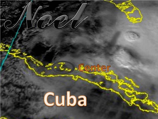
Here's an 18Z surface plot with satellite. Red crosshairs represent the center. All squalls displaced to the east due to shear. Note the winds along the FL east coast are down from yesterday. High pressure to the north is weakening and there's not as much cool air flowing down the southeast U.S. Coast today. Winds around the center of Noel are probably only in the 15 kt range. Haven't seen any reports of TS force winds near the squalls to the northeast as I was seeing yesterday. If there are any TS force winds, they're confined to some VERY small pockets in that squall about 70-90 miles NE of the center.

0 likes
Re: Tropical Storm NOEL : Discussions & Images
Evil Jeremy wrote:boat wrote:Why didn't the forecasters see this? Guess we shouldn't really trust the NHC forecasts and the mets very much. I hope there will be more storms next year. Many areas really need the rain. Atlanta is running out of H2o.
Cant trust them? They are doing the best they can! They are not gods that know the where, when, and the why with these storms!
Anyways, Welcome! Man, alot of new members today!
OK then
0 likes
Re: Tropical Storm NOEL : Discussions & Images
It looks like the MLC is moving northward towards the Central Bahamas:
http://www.goes.noaa.gov/HURRLOOPS/huirloop.html
considering the shear, I wouldn't worry that much about the remnant LLC...
http://www.goes.noaa.gov/HURRLOOPS/huirloop.html
considering the shear, I wouldn't worry that much about the remnant LLC...
0 likes
-
gatorcane
- S2K Supporter
- Posts: 23708
- Age: 48
- Joined: Sun Mar 13, 2005 3:54 pm
- Location: Boca Raton, FL
Re: Tropical Storm NOEL : Discussions & Images
wxman57 wrote:Here's an 18Z surface plot with satellite. Red crosshairs represent the center. All squalls displaced to the east due to shear. Note the winds along the FL east coast are down from yesterday. High pressure to the north is weakening and there's not as much cool air flowing down the southeast U.S. Coast today. Winds around the center of Noel are probably only in the 15 kt range. Haven't seen any reports of TS force winds near the squalls to the northeast as I was seeing yesterday. If there are any TS force winds, they're confined to some VERY small pockets in that squall about 70-90 miles NE of the center.
Good analysis but Noel is going to have some good time over the FL straits.....hopefully he won't strengthen much.
0 likes
Re: Tropical Storm NOEL : Discussions & Images
Remanant LLC...there is no remnant LLC, the LLC is still defined and is the centre of the storm...the convection is just sheared.
0 likes
-
Evil Jeremy
- S2K Supporter
- Posts: 5463
- Age: 32
- Joined: Mon Apr 10, 2006 2:10 pm
- Location: Los Angeles, CA

Re:
Derek Ortt wrote:I am close to cluess regarding what this will do. The fact that the LLC keeps becoming exposed (thanks, mid level shear) is what is making this such a tricky forecast
Derek - you have no idea how much more my respect for you just grew. Thank you for admitting to that. That to me is the sign of a great met.

0 likes
-
SouthFLTropics

- Category 5

- Posts: 4258
- Age: 50
- Joined: Thu Aug 14, 2003 8:04 am
- Location: Port St. Lucie, Florida
Re: Tropical Storm NOEL : Discussions & Images
gatorcane wrote:wxman57 wrote:Here's an 18Z surface plot with satellite. Red crosshairs represent the center. All squalls displaced to the east due to shear. Note the winds along the FL east coast are down from yesterday. High pressure to the north is weakening and there's not as much cool air flowing down the southeast U.S. Coast today. Winds around the center of Noel are probably only in the 15 kt range. Haven't seen any reports of TS force winds near the squalls to the northeast as I was seeing yesterday. If there are any TS force winds, they're confined to some VERY small pockets in that squall about 70-90 miles NE of the center.
Good analysis but Noel is going to have some good time over the FL straits.....hopefully he won't strengthen much.
He shouldn't strengthen much, if any, as long as the shear persists and the convection remains blown off to the east with the MLC.
SFT
0 likes

"those cuban cigars must be good  "
"
Way the storm is meandering around could be the genuine Cuban Rum! grin
CITY SKY/WX TMP DP RH WIND PRES REMARKS
W PALM BEACH PTSUNNY 79 76 90 E17G30 29.84F
FT LAUDER-EXEC MOSUNNY 82 72 71 NE22G33 29.79F
FT LAUDERDALE LGT RAIN 81 75 82 NE26 29.77F
POMPANO BEACH MOSUNNY 83 72 69 NE25G31 29.80F
PEMBROKE PINES MOSUNNY 81 75 82 NE25 29.81F
OPA LOCKA HVY RAIN 75 73 93 E16 29.79F FOG
MIAMI RAIN 76 72 87 E17G23 29.79F FOG
MIAMI BEACH N/A 78 74 88 E29G37 N/A
WEST KENDALL PTSUNNY 82 72 71 NE18G29 29.77F
HOMESTEAD MOSUNNY 82 75 79 NE20G29 29.76F
STATION/POSITION TEMP WIND PRES WAVE SWELL
AIR SEA DIR/SP/G HT/PER HT/PER
(F) (DEG/KT/KT) (MB) (FT/S) (FT/S)
LAKE WORTH 76 70/ 26/ 30 1011.3F
FOWEY ROCKS 80 82 60/ 25/ 26 1008.4F
SETTLEMENT POINT 76 60/ 25/ 30 1010.0F
Last edited by hiflyer on Wed Oct 31, 2007 2:18 pm, edited 1 time in total.
0 likes
Re: Tropical Storm NOEL : Discussions & Images
Frank2 wrote:It looks like the MLC is moving northward towards the Central Bahamas:
http://www.goes.noaa.gov/HURRLOOPS/huirloop.html
considering the shear, I wouldn't worry that much about the remnant LLC...
I always worry about remnants. I call it FoR - Fear of Remnants. Remnants have become powerful hurricanes before.
0 likes
Who is online
Users browsing this forum: No registered users and 50 guests