Hurricane NOEL : Discussions & Images

Moderator: S2k Moderators

Message
Author
destruction92
Category 1
Category 1
Posts: 312
Joined: Sun Jul 22, 2007 10:43 pm

Re: Re:

#3121 Postby destruction92 » Wed Oct 31, 2007 9:49 pm

'CaneFreak wrote:
destruction92 wrote:
'CaneFreak wrote:no one is yelling. If people would start listening to other people sharing their knowledge and learn from there mistakes, and stop making the same mistakes OVER AND OVER AND OVER AND OVER AND OVER again, then no one would be mad or even the slightest bit frustrated.


Seriously, I have not seen you on much on this thread about Noel...all of a sudden, you are everywhere.

I do think you could tone down your "smarter than thou" attitude...you gotta understand that this is not the tropical analysis forum but the "talkin' tropics" forum.

If you are frustrated by the ignorance here, then you are free to ignore them, don't read them, or just leave the talkin' tropics forum and go to the pro-mets section.

Now, back to Noel....I don't know why you are getting so ramped up, unless you have property in the Bahamas...otherwise the Carolinas are safe as ever. Speaking of Carolinas, I am sure you know your stuff since you have been through more tropical systems than any Floridian...right?

North Carolina is the hurricane capital of the U.S. mainland and has got hit by more hurricanes than Florida by a long shot.


Whatever dude. You and I both werent here in the good ole days when this forum was full of KNOWLEDGEABLE people that knew what was going on and now everyone thinks they know the weather and they really dont.


Since this is a forum of learning I feel it necessary to correct my mistake pointed out to me......I am surprised you did not catch me on my mistake...I edited my previous posts to include the following statements:
"Correction: After reading historical records, climatological norms, and knowing that Florida has like 4 times as much coastline as North Carolina, I can confidently affirm that Florida is the hurricane capital of the mainland U.S. and has more hurricanes than any other state, including North Carolina."
0 likes   

User avatar
Blown Away
S2K Supporter
S2K Supporter
Posts: 10146
Joined: Wed May 26, 2004 6:17 am

Re: Re:

#3122 Postby Blown Away » Wed Oct 31, 2007 9:50 pm

'CaneFreak wrote:
destruction92 wrote:
'CaneFreak wrote:no one is yelling. If people would start listening to other people sharing their knowledge and learn from there mistakes, and stop making the same mistakes OVER AND OVER AND OVER AND OVER AND OVER again, then no one would be mad or even the slightest bit frustrated.


Seriously, I have not seen you on much on this thread about Noel...all of a sudden, you are everywhere.

I do think you could tone down your "smarter than thou" attitude...you gotta understand that this is not the tropical analysis forum but the "talkin' tropics" forum.

If you are frustrated by the ignorance here, then you are free to ignore them, don't read them, or just leave the talkin' tropics forum and go to the pro-mets section.

Now, back to Noel....I don't know why you are getting so ramped up, unless you have property in the Bahamas...otherwise the Carolinas are safe as ever. Speaking of Carolinas, I am sure you know your stuff since you have been through more tropical systems than any Floridian...right?

North Carolina is the hurricane capital of the U.S. mainland and has got hit by more hurricanes than Florida by a long shot.


Whatever dude. You and I both werent here in the good ole days when this forum was full of KNOWLEDGEABLE people that knew what was going on and now everyone thinks they know the weather and they really dont.


You should be chating in the "Tropical Analysis" forum w/ your expert knowledge.
0 likes   

User avatar
Bgator
Category 2
Category 2
Posts: 649
Joined: Mon Sep 05, 2005 12:29 pm
Location: Orlando, FL

#3123 Postby Bgator » Wed Oct 31, 2007 9:51 pm

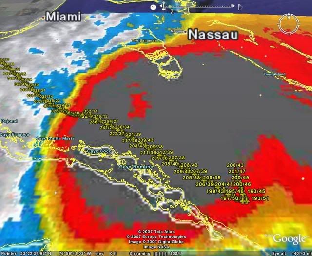
Hurakan can you put the vortex center on there?
0 likes   

destruction92
Category 1
Category 1
Posts: 312
Joined: Sun Jul 22, 2007 10:43 pm

Re: Tropical Storm NOEL : Discussions & Images

#3124 Postby destruction92 » Wed Oct 31, 2007 9:52 pm

gatorcane wrote:destruction92 :uarrow: :uarrow: :uarrow:

Its moving NW still...


From 11 PM advisory, "PRESENT MOVEMENT TOWARD THE NORTH OR 360 DEGREES AT 3 KT"
0 likes   

User avatar
SouthFLTropics
Category 5
Category 5
Posts: 4236
Age: 50
Joined: Thu Aug 14, 2003 8:04 am
Location: Port St. Lucie, Florida

Re:

#3125 Postby SouthFLTropics » Wed Oct 31, 2007 9:52 pm

ericinmia wrote:So anyone have any idea on what the 'ghost' on the two radar's are???

Maybe a new device the military is testing that sends a shockwave to the storm to deflect it and weaken it? :double:

Seriously... it really interest me. Since two separate radar sites are picking up the SAME exact thing.


Didn't you hear...it's the alien spacecraft floating around in Noel's outerbands. We have accomplished a significant milestone tonight. We have solved the mystery of the Bermuda Triangle!

SFT
0 likes   

User avatar
HURAKAN
Professional-Met
Professional-Met
Posts: 46086
Age: 38
Joined: Thu May 20, 2004 4:34 pm
Location: Key West, FL
Contact:

#3126 Postby HURAKAN » Wed Oct 31, 2007 9:52 pm

Image
0 likes   

User avatar
'CaneFreak
Category 5
Category 5
Posts: 1486
Joined: Mon Jun 05, 2006 10:50 am
Location: New Bern, NC

Re: Tropical Storm NOEL : Discussions & Images

#3127 Postby 'CaneFreak » Wed Oct 31, 2007 9:53 pm

gatorcane wrote:destruction92 :uarrow: :uarrow: :uarrow:

Its moving NW still...


NOEL IS MOVING TOWARD THE NORTH NEAR 3 MPH...6 KM/HR...AND THIS SLOW
MOTION IS EXPECTED TO CONTINUE ON THURSDAY. A GRADUAL TURN TO THE
NORTHEAST IS EXPECTED THEREAFTER.
0 likes   

User avatar
HURAKAN
Professional-Met
Professional-Met
Posts: 46086
Age: 38
Joined: Thu May 20, 2004 4:34 pm
Location: Key West, FL
Contact:

Re:

#3128 Postby HURAKAN » Wed Oct 31, 2007 9:53 pm

Bgator wrote:Hurakan can you put the vortex center on there?


Coming up!

Image
0 likes   

User avatar
Thunder44
Category 5
Category 5
Posts: 5922
Age: 44
Joined: Mon Jun 09, 2003 7:53 pm
Location: New York City

Re: Tropical Storm NOEL : Discussions & Images

#3129 Postby Thunder44 » Wed Oct 31, 2007 9:54 pm

Bgator wrote:recon said the center would be at 23N and 78.7W....but the NHC went with a different point.


I don't know why the did that. Maybe they believe it was bad fix. However you see a hook-like appearance to convection in the same area on the IR-4 imagery.
0 likes   

User avatar
Evil Jeremy
S2K Supporter
S2K Supporter
Posts: 5463
Age: 32
Joined: Mon Apr 10, 2006 2:10 pm
Location: Los Angeles, CA

Re: Tropical Storm NOEL : Discussions & Images

#3130 Postby Evil Jeremy » Wed Oct 31, 2007 9:55 pm

Yea, but after the advisory was issued, the Hurricane Hunters found the center more NW than thought, so it is unofficially moving NW or NNW in my opinion.
0 likes   

User avatar
Blown Away
S2K Supporter
S2K Supporter
Posts: 10146
Joined: Wed May 26, 2004 6:17 am

Re: Tropical Storm NOEL : Discussions & Images

#3131 Postby Blown Away » Wed Oct 31, 2007 9:55 pm

'CaneFreak wrote:
gatorcane wrote:destruction92 :uarrow: :uarrow: :uarrow:

Its moving NW still...


NOEL IS MOVING TOWARD THE NORTH NEAR 3 MPH...6 KM/HR...AND THIS SLOW
MOTION IS EXPECTED TO CONTINUE ON THURSDAY. A GRADUAL TURN TO THE
NORTHEAST IS EXPECTED THEREAFTER.


NHC was saying NNW all day but actually turned out to be W.
0 likes   

Derek Ortt

#3132 Postby Derek Ortt » Wed Oct 31, 2007 9:55 pm

because the 0300 advisory position is a 3 hour forecast, not a true position.
0 likes   

CrazyC83
Professional-Met
Professional-Met
Posts: 34002
Joined: Tue Mar 07, 2006 11:57 pm
Location: Deep South, for the first time!

#3133 Postby CrazyC83 » Wed Oct 31, 2007 9:56 pm

URNT15 KNHC 010257
AF304 1016A NOEL HDOB 23 20071101
024530 2217N 07706W 8420 01516 0025 +168 +168 199042 043 029 010 00
024600 2219N 07706W 8421 01516 0024 +169 +169 196041 042 029 009 00
024630 2220N 07706W 8422 01516 0024 +170 +170 193036 037 028 010 00
024700 2222N 07707W 8418 01518 0023 +172 +172 196037 038 029 010 00
024730 2224N 07707W 8419 01518 0024 +171 +171 199038 039 029 010 00
024800 2226N 07707W 8422 01517 0025 +170 +170 199038 039 028 009 00
024830 2228N 07707W 8420 01518 0026 +170 +170 197037 038 027 009 00
024900 2230N 07707W 8420 01520 0026 +170 +170 195036 036 028 009 00
024930 2232N 07707W 8421 01520 0027 +169 +169 195035 035 029 010 00
025000 2234N 07708W 8423 01512 0021 +173 +173 197035 036 031 010 00
025030 2236N 07708W 8418 01516 0014 +178 +169 197039 039 033 010 00
025100 2238N 07708W 8422 01509 0010 +183 +164 196040 041 034 011 00
025130 2240N 07708W 8422 01506 0006 +186 +163 195040 041 035 011 00
025200 2242N 07708W 8421 01510 0007 +184 +162 196041 042 034 011 00
025230 2244N 07708W 8430 01504 0014 +176 +173 195040 040 031 011 00
025300 2246N 07709W 8419 01512 0011 +181 +169 195039 039 030 011 00
025330 2248N 07709W 8418 01512 0009 +181 +168 194039 040 031 011 00
025400 2250N 07709W 8422 01509 0014 +174 +174 194038 038 029 011 00
025430 2252N 07709W 8424 01505 0017 +166 +166 193037 038 028 012 00
025500 2254N 07709W 8418 01509 0016 +163 +163 191039 039 031 012 00
$$
;
0 likes   

User avatar
HURAKAN
Professional-Met
Professional-Met
Posts: 46086
Age: 38
Joined: Thu May 20, 2004 4:34 pm
Location: Key West, FL
Contact:

#3134 Postby HURAKAN » Wed Oct 31, 2007 9:57 pm

Image
0 likes   

User avatar
SouthFLTropics
Category 5
Category 5
Posts: 4236
Age: 50
Joined: Thu Aug 14, 2003 8:04 am
Location: Port St. Lucie, Florida

#3135 Postby SouthFLTropics » Wed Oct 31, 2007 9:57 pm

Boy they better get this right...I'd hate to wake up tomorrow morning with a strong TS or Cat 1 knocking on Miami's doorstep. Bahama's is worried enough about development that they've issued a hurricane watch.

SFT
0 likes   

User avatar
'CaneFreak
Category 5
Category 5
Posts: 1486
Joined: Mon Jun 05, 2006 10:50 am
Location: New Bern, NC

Re: Re:

#3136 Postby 'CaneFreak » Wed Oct 31, 2007 9:57 pm

Destruction92:

Gotcha. Good catch. *Beats himself over the head*. Glad to see you learned something tonight. I saw your earlier post about the pressure gradient. Glad you remember that concept or at least understand what I was saying. I feel good now. Thanks. Oh, and thanks for correcting me.
0 likes   

User avatar
Vortex
S2K Supporter
S2K Supporter
Posts: 4644
Age: 53
Joined: Fri Aug 01, 2003 9:34 pm
Location: Hilton Head, SC

#3137 Postby Vortex » Wed Oct 31, 2007 9:58 pm

Listening to bahamain radio from andros and the DJ says nice evening mhan with this rain as the storm heads to cuba and florida...
0 likes   

User avatar
HURAKAN
Professional-Met
Professional-Met
Posts: 46086
Age: 38
Joined: Thu May 20, 2004 4:34 pm
Location: Key West, FL
Contact:

#3138 Postby HURAKAN » Wed Oct 31, 2007 9:59 pm

Image
0 likes   

User avatar
boca
Category 5
Category 5
Posts: 6367
Age: 60
Joined: Mon Dec 15, 2003 8:49 am
Location: Boca Raton,FL

Re: Tropical Storm NOEL : Discussions & Images

#3139 Postby boca » Wed Oct 31, 2007 9:59 pm

I'm not staying up again for the 2nd night. Let this storm just move it outta here.
0 likes   

User avatar
Bgator
Category 2
Category 2
Posts: 649
Joined: Mon Sep 05, 2005 12:29 pm
Location: Orlando, FL

#3140 Postby Bgator » Wed Oct 31, 2007 10:00 pm

thanks a lot hurakan if you can keep doing this until you go to bed that would be awesome!
0 likes   


Return to “2007”

Who is online

Users browsing this forum: No registered users and 6 guests