Hurricane NOEL : Discussions & Images

Moderator: S2k Moderators

Message
Author
User avatar
Bgator
Category 2
Category 2
Posts: 649
Joined: Mon Sep 05, 2005 12:29 pm
Location: Orlando, FL

Re:

#3141 Postby Bgator » Wed Oct 31, 2007 10:01 pm

Derek Ortt wrote:because the 0300 advisory position is a 3 hour forecast, not a true position.

What do you mean?
0 likes   

HurricaneRobert
Category 3
Category 3
Posts: 812
Joined: Fri May 18, 2007 9:31 pm

Re: Tropical Storm NOEL : Discussions & Images

#3142 Postby HurricaneRobert » Wed Oct 31, 2007 10:01 pm

On the other hand, if Noel makes it to hurricane strength it is more likely that the name will be retired. WMO would do some crazy stuff like they did with Gordon (even though that made hurricane strength as well).
Last edited by HurricaneRobert on Wed Oct 31, 2007 10:02 pm, edited 1 time in total.
0 likes   

tolakram
Admin
Admin
Posts: 20009
Age: 62
Joined: Sun Aug 27, 2006 8:23 pm
Location: Florence, KY (name is Mark)

Re: Tropical Storm NOEL Recon discussion

#3143 Postby tolakram » Wed Oct 31, 2007 10:01 pm

So I'm guessing Cuba has given the OK to fly just offshore, or does free airspace (or whatever) extend that close to the shoreline?
0 likes   

User avatar
'CaneFreak
Category 5
Category 5
Posts: 1486
Joined: Mon Jun 05, 2006 10:50 am
Location: New Bern, NC

Re:

#3144 Postby 'CaneFreak » Wed Oct 31, 2007 10:01 pm

Derek Ortt wrote:because the 0300 advisory position is a 3 hour forecast, not a true position.


CORRECTED:
Good point, but the point is the mean storm movement tendencies over the last several hours have been trending NORTH. Correct? In other words, the average storm movement over the past 4 hours has been trending towards 360 degrees or 0 degrees due north. In calculus terms, d-theta is approaching 360 degrees.
Last edited by 'CaneFreak on Wed Oct 31, 2007 10:06 pm, edited 1 time in total.
0 likes   

User avatar
BigA
Professional-Met
Professional-Met
Posts: 1317
Joined: Sun Jul 24, 2005 10:56 pm

Re: Tropical Storm NOEL : Discussions & Images

#3145 Postby BigA » Wed Oct 31, 2007 10:02 pm

Vortex wrote:Listening to bahamain radio from andros and the DJ says nice evening mhan with this rain as the storm heads to cuba and florida...


That's not a good thing. Andros looks like it could receive a direct hit, although "direct" may not be entirely accurate with a system this broad and assymetric
0 likes   

User avatar
wxman57
Moderator-Pro Met
Moderator-Pro Met
Posts: 22979
Age: 67
Joined: Sat Jun 21, 2003 8:06 pm
Location: Houston, TX (southwest)

Re: Tropical Storm NOEL : Discussions & Images

#3146 Postby wxman57 » Wed Oct 31, 2007 10:03 pm

Central pressure isn't falling, though. Max SFMR winds only 34 kts, with 28-30 kts SFMR below the 51kt FL wind east of the center. Upper-level trof axis is moving into Florida now. Steering currents about to shift as southwest flow increases in the mid levels. Will be a different upper and mid-level regime out there by morning. Noel has never been able to align its core vertically, and the time for that is running short. It still doesn't look like much of a threat to Florida, as close as it is.

One other item of interest. Look at this plot of recon obs. Note that the strongest wind is farthest from the center to the southeast. That's not typical of a tropical low. A well organized tropical storm would have a wind field just the opposite, with strongest winds near the center, diminishing outward.

http://i40.photobucket.com/albums/e244/zdtadmin/Noel/1RECON_NOEL2.jpg

Time for bed. Have to be at work at 6am.
0 likes   

User avatar
Vortex
S2K Supporter
S2K Supporter
Posts: 4644
Age: 53
Joined: Fri Aug 01, 2003 9:34 pm
Location: Hilton Head, SC

#3147 Postby Vortex » Wed Oct 31, 2007 10:03 pm

Folks with the cloud deck expanding significantly to the SW and some west this tell me that the atmosphere is going to allow for a period of some rapid intensification the next 6-12 hours...We are watching a storm mature into a hurricane during the next few hours...Fascinating stuff...Hope all are enjoying the show Mother Nature is beginning to put on tonight...
0 likes   

Stratosphere747
Category 5
Category 5
Posts: 3772
Joined: Thu Sep 11, 2003 8:34 pm
Location: Surfside Beach/Freeport Tx
Contact:

Re: Tropical Storm NOEL Recon discussion

#3148 Postby Stratosphere747 » Wed Oct 31, 2007 10:03 pm

tolakram wrote:So I'm guessing Cuba has given the OK to fly just offshore, or does free airspace (or whatever) extend that close to the shoreline?


I doubt they have ever entered Cuban airspace for any of the missions for Noel.
0 likes   

destruction92
Category 1
Category 1
Posts: 312
Joined: Sun Jul 22, 2007 10:43 pm

Re: Tropical Storm NOEL : Discussions & Images

#3149 Postby destruction92 » Wed Oct 31, 2007 10:05 pm

Evil Jeremy wrote:Yea, but after the advisory was issued, the Hurricane Hunters found the center more NW than thought, so it is unofficially moving NW or NNW in my opinion.


Hey Jeremy...could you give me the plot of Noel's coordinates according to the the hurricane hunters....I take these guys seriously since they have the most current, up-to-date, accurate information.

But, Noel is definitely NOT moving NNW....more like NNE.....if anything proves true, probably just a center relocation but nothing more than that IMO.....Why didn't the NHC CANCEL tropical storm watches for Florida....the 11 PM cone has shifted further EAST.....http://www.nhc.noaa.gov/archiv ... p_3W.shtml
0 likes   

CrazyC83
Professional-Met
Professional-Met
Posts: 34002
Joined: Tue Mar 07, 2006 11:57 pm
Location: Deep South, for the first time!

#3150 Postby CrazyC83 » Wed Oct 31, 2007 10:06 pm

URNT15 KNHC 010307
AF304 1016A NOEL HDOB 24 20071101
025530 2256N 07709W 8422 01506 0018 +162 +162 190040 041 032 012 00
025600 2258N 07710W 8419 01508 0014 +167 +167 186039 040 032 012 00
025630 2300N 07710W 8422 01503 0009 +173 +173 185039 039 032 011 00
025700 2302N 07710W 8422 01504 0008 +175 +168 182037 038 032 012 00
025730 2304N 07710W 8418 01510 0009 +175 +164 183036 036 031 012 00
025800 2306N 07710W 8420 01509 0013 +172 +166 184035 035 028 012 00
025830 2308N 07710W 8419 01510 0015 +168 +168 183036 036 027 013 00
025900 2309N 07711W 8420 01505 0012 +168 +168 183038 039 030 012 00
025930 2311N 07711W 8423 01504 0016 +163 +163 179038 038 028 012 00
030000 2313N 07711W 8418 01509 0014 +167 +167 178039 040 024 011 00
030030 2315N 07711W 8418 01508 0011 +168 +168 179041 042 029 010 00
030100 2317N 07711W 8425 01502 0014 +166 +166 174043 044 030 011 00
030130 2319N 07711W 8418 01509 0022 +153 +153 171045 047 032 015 00
030200 2321N 07711W 8431 01499 0025 +151 +151 171034 035 035 014 00
030230 2323N 07712W 8418 01509 0015 +164 +164 174042 044 033 010 00
030300 2325N 07712W 8427 01502 0015 +168 +168 168040 042 032 010 00
030330 2327N 07712W 8417 01510 0027 +152 +152 162042 044 033 012 00
030400 2329N 07712W 8424 01506 0017 +168 +168 164038 039 033 011 00
030430 2331N 07712W 8422 01509 0016 +172 +172 165037 039 032 010 00
030500 2333N 07712W 8420 01511 0015 +174 +174 161037 037 031 010 00
$$
;
0 likes   

Stratosphere747
Category 5
Category 5
Posts: 3772
Joined: Thu Sep 11, 2003 8:34 pm
Location: Surfside Beach/Freeport Tx
Contact:

Re:

#3151 Postby Stratosphere747 » Wed Oct 31, 2007 10:07 pm

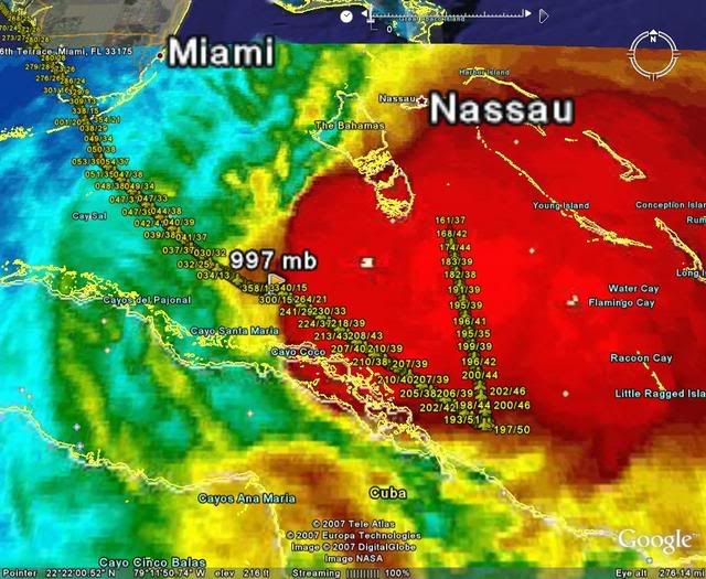
Vortex wrote:Folks with the cloud deck expanding significantly to the SW and some west this tell me that the atmosphere is going to allow for a period of some rapid intensification the next 6-12 hours...We are watching a storm mature into a hurricane during the next few hours...Fascinating stuff...Hope all are enjoying the show Mother Nature is beginning to put on tonight...


We had a minor discussion about this earlier and feel the need to point it out again. The term RI is overused and very misleading. There is no indication at all that Noel is about to enter a RI cycle.
0 likes   

User avatar
Bgator
Category 2
Category 2
Posts: 649
Joined: Mon Sep 05, 2005 12:29 pm
Location: Orlando, FL

#3152 Postby Bgator » Wed Oct 31, 2007 10:07 pm

Its not moving NNE, for sure, and they didnt cancel them because they rather be safe than sorry, and the wind field is expanding.
0 likes   

bocadude86
Tropical Depression
Tropical Depression
Posts: 52
Joined: Wed Sep 12, 2007 3:29 pm
Location: Boca Raton, Fl

#3153 Postby bocadude86 » Wed Oct 31, 2007 10:08 pm

Is that the center showing up on the long range radar out of miami?
0 likes   

tolakram
Admin
Admin
Posts: 20009
Age: 62
Joined: Sun Aug 27, 2006 8:23 pm
Location: Florence, KY (name is Mark)

Re: Tropical Storm NOEL : Discussions & Images

#3154 Postby tolakram » Wed Oct 31, 2007 10:10 pm

destruction92 wrote:
Evil Jeremy wrote:Yea, but after the advisory was issued, the Hurricane Hunters found the center more NW than thought, so it is unofficially moving NW or NNW in my opinion.


Hey Jeremy...could you give me the plot of Noel's coordinates according to the the hurricane hunters....I take these guys seriously since they have the most current, up-to-date, accurate information.

But, Noel is definitely NOT moving NNW....more like NNE.....if anything proves true, probably just a center relocation but nothing more than that IMO.....Why didn't the NHC CANCEL tropical storm watches for Florida....the 11 PM cone has shifted further EAST.....http://www.nhc.noaa.gov/archiv ... p_3W.shtml


They explained their reasoning in the 11pm update. Any shift to the left plus an expanding wind field could put tropical storm force winds on the coast.

http://www.nhc.noaa.gov/text/refresh/MI ... 0238.shtml

SINCE NOEL IS ALREADY MOVING NORTHWARD AND IS FORECAST TO TURN
NORTHEASTWARD AWAY FROM FLORIDA...AND TROPICAL STORM FORCE WINDS
ARE FORECAST TO REMAIN OFFSHORE ...THE ISSUANCE OF TROPICAL STORM
WARNING IS NOT REQUIRED TONIGHT. HOWEVER...ANY UNEXPECTED INCREASE
IN THE WIND RADII WEST OF THE CYCLONE OR A DEVIATION TO THE LEFT OF
THE FORECAST TRACK COULD PROMPT THE ISSUANCE OF A TROPICAL STORM
WARNING.
0 likes   

User avatar
cycloneye
Admin
Admin
Posts: 145336
Age: 68
Joined: Thu Oct 10, 2002 10:54 am
Location: San Juan, Puerto Rico

Re:

#3155 Postby cycloneye » Wed Oct 31, 2007 10:10 pm

bocadude86 wrote:Is that the center showing up on the long range radar out of miami?


But where is the link?
0 likes   

User avatar
gatorcane
S2K Supporter
S2K Supporter
Posts: 23691
Age: 47
Joined: Sun Mar 13, 2005 3:54 pm
Location: Boca Raton, FL

Re: Tropical Storm NOEL : Discussions & Images

#3156 Postby gatorcane » Wed Oct 31, 2007 10:10 pm

destruction92 wrote:
Evil Jeremy wrote:Yea, but after the advisory was issued, the Hurricane Hunters found the center more NW than thought, so it is unofficially moving NW or NNW in my opinion.


Hey Jeremy...could you give me the plot of Noel's coordinates according to the the hurricane hunters....I take these guys seriously since they have the most current, up-to-date, accurate information.

But, Noel is definitely NOT moving NNW....more like NNE.....if anything proves true, probably just a center relocation but nothing more than that IMO.....Why didn't the NHC CANCEL tropical storm watches for Florida....the 11 PM cone has shifted further EAST.....http://www.nhc.noaa.gov/archiv ... p_3W.shtml


destruction you are extreme -- last night you were saying FL is in trouble and tonight you are arguing the total opposite way...

:lol:
0 likes   

User avatar
HURAKAN
Professional-Met
Professional-Met
Posts: 46086
Age: 38
Joined: Thu May 20, 2004 4:34 pm
Location: Key West, FL
Contact:

#3157 Postby HURAKAN » Wed Oct 31, 2007 10:11 pm

Image
0 likes   

User avatar
'CaneFreak
Category 5
Category 5
Posts: 1486
Joined: Mon Jun 05, 2006 10:50 am
Location: New Bern, NC

Re:

#3158 Postby 'CaneFreak » Wed Oct 31, 2007 10:11 pm

Bgator wrote:Its not moving NNE, for sure, and they didnt cancel them because they rather be safe than sorry, and the wind field is expanding.


Note that the strongest wind is farthest from the center to the southeast.

It may be expanding but eastward not westward.
0 likes   

User avatar
SouthFLTropics
Category 5
Category 5
Posts: 4236
Age: 50
Joined: Thu Aug 14, 2003 8:04 am
Location: Port St. Lucie, Florida

#3159 Postby SouthFLTropics » Wed Oct 31, 2007 10:12 pm

If you look at the Western Atlantic water vapor image on the NHC site you can see the trough digging Southeast. Here it come's to save the day! At least for FLA that is. The Bahama's on the other hand could have a real nasty morning. The trough could amplify Noel's winds kinda like what happened with Wilma in 2005.

SFT
0 likes   

bocadude86
Tropical Depression
Tropical Depression
Posts: 52
Joined: Wed Sep 12, 2007 3:29 pm
Location: Boca Raton, Fl

#3160 Postby bocadude86 » Wed Oct 31, 2007 10:13 pm

Tropical storm warning now up for the costal waters of South Fla
0 likes   


Return to “2007”

Who is online

Users browsing this forum: No registered users and 2 guests