Hurricane NOEL : Discussions & Images
Moderator: S2k Moderators


Re: Tropical Storm NOEL Recon Obs
Wow, 993 or below! This thing is kicking. I hope the Bahamas are ready for this.
0 likes
-
Evil Jeremy

- S2K Supporter

- Posts: 5463
- Age: 32
- Joined: Mon Apr 10, 2006 2:10 pm
- Location: Los Angeles, CA
-
gatorcane

- S2K Supporter
- Posts: 23708
- Age: 48
- Joined: Sun Mar 13, 2005 3:54 pm
- Location: Boca Raton, FL
Re: Re:
CrazyC83 wrote:Vortex wrote:here we go...RI underway?????
No wind reports have suggested strengthening yet though...
pressures fall first followed by winds -- it really is a matter of time....
I think possibly CAT 2 before all is done... (just my opinion)
0 likes


Re: Tropical Storm NOEL : Discussions & Images
Winds usually take a bit to fall, but i dont think RI is underway, just some strengthening.
0 likes
-
CrazyC83
- Professional-Met

- Posts: 34315
- Joined: Tue Mar 07, 2006 11:57 pm
- Location: Deep South, for the first time!
Re: Re:
gatorcane wrote:CrazyC83 wrote:Vortex wrote:here we go...RI underway?????
No wind reports have suggested strengthening yet though...
pressures fall first followed by winds -- it really is a matter of time....
I think possibly CAT 2 before all is done... (just my opinion)
Also a 4mb drop is hardly "rapid intensification", it could have been that they missed the core last time...it is definitely deepening but it will take more information to confirm any trends.
Last edited by CrazyC83 on Wed Oct 31, 2007 10:53 pm, edited 1 time in total.
0 likes
-
Derek Ortt
winds are actually a lot LOWER than before. The earlier strong winds may have been associated in combination with the high. That high is weakening; thus, the winds are dropping and we are starting to see the winds with the circulation itself. This should still become a cane by morning though
0 likes
-
'CaneFreak

- Category 5

- Posts: 1487
- Joined: Mon Jun 05, 2006 10:50 am
- Location: New Bern, NC
Re:
gatorcane wrote:Pressures are rising across SE Florida:
W PALM BEACH PTCLDY 79 72 79 E14 29.82S
FT LAUDER-EXEC PTCLDY 79 72 78 NE16G29 29.79S
FT LAUDERDALE MOCLDY 81 71 71 NE18G25 29.78R
POMPANO BEACH PTCLDY 79 72 78 E22G28 29.80R
PEMBROKE PINES LGT RAIN 78 72 81 NE16 29.80S
OPA LOCKA MOCLDY 79 73 82 NE15G24 29.78S
MIAMI RAIN 79 72 79 NE17G23 29.78R
MIAMI BEACH N/A 80 75 84 NE28G39 N/A
WEST KENDALL CLOUDY 78 73 84 NE15 29.77R
HOMESTEAD PTCLDY 78 74 87 NE21G28 29.76S
Winds on the decrease? Pressures are rising? Really?
0 likes
-
gatorcane
- S2K Supporter
- Posts: 23708
- Age: 48
- Joined: Sun Mar 13, 2005 3:54 pm
- Location: Boca Raton, FL
Re:
Derek Ortt wrote:winds are actually a lot LOWER than before. The earlier strong winds may have been associated in combination with the high. That high is weakening; thus, the winds are dropping and we are starting to see the winds with the circulation itself. This should still become a cane by morning though
agreed cane by morning............and hopefully moving NNE by then.
Last edited by gatorcane on Wed Oct 31, 2007 10:54 pm, edited 1 time in total.
0 likes
Re: Tropical Storm NOEL : Discussions & Images
75 min ago
sometimes i get "lucky"
cpdaman wrote:.......................
lastly the recon reports seem to indicate a center relocation may be in the process of occuring a bit to the east circa 23.1N and 78/ 77.9 the plane has yet to sample that latitude and longitude so this is just my opinion
their was a pocket of lower pressure SE of the old LLC reported on recon and i'm betting if they sample the area just north i.e 23/ 78 they will find falling pressure
sometimes i get "lucky"
0 likes
-
CrazyC83
- Professional-Met
- Posts: 34315
- Joined: Tue Mar 07, 2006 11:57 pm
- Location: Deep South, for the first time!
URNT15 KNHC 010357
AF304 1016A NOEL HDOB 29 20071101
034530 2325N 07824W 8418 01456 9929 +209 +185 075008 010 013 010 03
034600 2323N 07824W 8420 01453 9926 +215 +180 069002 002 000 009 00
034630 2321N 07823W 8419 01453 9924 +218 +177 009003 004 000 009 00
034700 2320N 07823W 8419 01453 9927 +212 +178 283006 009 000 008 03
034730 2318N 07822W 8417 01456 9932 +203 +184 228016 021 999 999 03
034800 2319N 07820W 8422 01452 9937 +192 +192 213024 025 999 999 03
034830 2319N 07820W 8422 01452 9937 +195 +189 200020 023 027 009 03
034900 2323N 07819W 8418 01453 9933 +199 +189 181017 020 024 009 03
034930 2324N 07819W 8425 01447 9928 +207 +188 153016 017 022 009 00
035000 2326N 07820W 8424 01449 9940 +189 +189 130020 022 019 010 00
035030 2328N 07820W 8422 01456 9944 +188 +188 126022 024 015 010 00
035100 2330N 07820W 8422 01459 9953 +179 +179 127025 026 017 010 00
035130 2330N 07820W 8422 01459 9961 +174 +174 120026 026 022 010 00
035200 2333N 07820W 8418 01467 9955 +187 +186 119025 026 029 010 00
035230 2335N 07820W 8415 01474 9961 +180 +180 120027 029 031 011 00
035300 2337N 07820W 8424 01464 9969 +172 +172 113034 037 032 010 00
035330 2339N 07820W 8424 01472 9970 +177 +177 106035 037 031 010 00
035400 2340N 07820W 8413 01485 9967 +187 +187 106031 032 032 009 00
035430 2342N 07820W 8421 01478 9970 +186 +184 103032 033 031 009 00
035500 2344N 07820W 8423 01477 9971 +191 +178 093035 036 029 009 00
$$
;
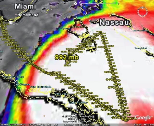
992mb in a large center. No sign of wind increases yet though.
AF304 1016A NOEL HDOB 29 20071101
034530 2325N 07824W 8418 01456 9929 +209 +185 075008 010 013 010 03
034600 2323N 07824W 8420 01453 9926 +215 +180 069002 002 000 009 00
034630 2321N 07823W 8419 01453 9924 +218 +177 009003 004 000 009 00
034700 2320N 07823W 8419 01453 9927 +212 +178 283006 009 000 008 03
034730 2318N 07822W 8417 01456 9932 +203 +184 228016 021 999 999 03
034800 2319N 07820W 8422 01452 9937 +192 +192 213024 025 999 999 03
034830 2319N 07820W 8422 01452 9937 +195 +189 200020 023 027 009 03
034900 2323N 07819W 8418 01453 9933 +199 +189 181017 020 024 009 03
034930 2324N 07819W 8425 01447 9928 +207 +188 153016 017 022 009 00
035000 2326N 07820W 8424 01449 9940 +189 +189 130020 022 019 010 00
035030 2328N 07820W 8422 01456 9944 +188 +188 126022 024 015 010 00
035100 2330N 07820W 8422 01459 9953 +179 +179 127025 026 017 010 00
035130 2330N 07820W 8422 01459 9961 +174 +174 120026 026 022 010 00
035200 2333N 07820W 8418 01467 9955 +187 +186 119025 026 029 010 00
035230 2335N 07820W 8415 01474 9961 +180 +180 120027 029 031 011 00
035300 2337N 07820W 8424 01464 9969 +172 +172 113034 037 032 010 00
035330 2339N 07820W 8424 01472 9970 +177 +177 106035 037 031 010 00
035400 2340N 07820W 8413 01485 9967 +187 +187 106031 032 032 009 00
035430 2342N 07820W 8421 01478 9970 +186 +184 103032 033 031 009 00
035500 2344N 07820W 8423 01477 9971 +191 +178 093035 036 029 009 00
$$
;
992mb in a large center. No sign of wind increases yet though.
0 likes

-
Derek Ortt
-
destruction92
- Category 1

- Posts: 312
- Joined: Sun Jul 22, 2007 10:43 pm
Re: Tropical Storm NOEL : Discussions & Images
I would like to get some of your opinions, fellow ST2K members....Any indications of Noel's latest movement and location of center from Recon and hurricane hunters?
Someone please explain the implications of the following image...the steering currents from the Atlantic high pressure still look to be in place from east to west....

Someone please explain the implications of the following image...the steering currents from the Atlantic high pressure still look to be in place from east to west....
0 likes
-
'CaneFreak
- Category 5
- Posts: 1487
- Joined: Mon Jun 05, 2006 10:50 am
- Location: New Bern, NC
Re:
Bgator wrote:Looks like recons new center will be near 23.4N 78.4W, so actually a bit east of the NHC at 11pm.
Yes, and that would make sense. Why? Expanding convection to the SW indicates a center relocation under the deeper convection. The system is strengthening and this is all explained by what is happening. There are weak upper level winds in the vicinity of the core right now due to the fact that there is a trough to the north causing an upper level ridge to be just to the south due to an eddy of stagnant air in the upper levels of the atmosphere. Put it this way, whenever you have winds blowing sw to ne due to a trough, you are bound to have an upper level anticyclone at the base of that trough because of the physics of the upper atmosphere. Read a bunch of met books and you will understand that too.
0 likes
Who is online
Users browsing this forum: No registered users and 31 guests