Hurricane NOEL : Discussions & Images
Moderator: S2k Moderators
-
CrazyC83
- Professional-Met

- Posts: 34315
- Joined: Tue Mar 07, 2006 11:57 pm
- Location: Deep South, for the first time!
URNT15 KNHC 012219
AF306 1216A NOEL HDOB 16 20071101
220730 2526N 07948W 3758 07988 0366 -155 -499 266043 043 030 001 00
220800 2525N 07945W 3759 07985 0366 -155 -499 267043 043 029 002 00
220830 2523N 07943W 3759 07986 0367 -155 -498 267043 043 031 001 03
220900 2522N 07940W 3759 07988 0368 -155 -498 266043 043 032 000 00
220930 2521N 07937W 3759 07990 0369 -155 -498 267043 043 028 000 00
221000 2520N 07934W 3758 07990 0369 -155 -497 269042 042 033 000 00
221030 2519N 07931W 3759 07989 0370 -155 -497 270041 042 031 000 00
221100 2518N 07929W 3758 07991 0370 -155 -496 270041 041 026 002 00
221130 2516N 07926W 3759 07989 0370 -155 -496 272041 041 025 001 00
221200 2515N 07923W 3759 07991 0372 -155 -496 274039 039 025 003 00
221230 2513N 07921W 3758 07992 0372 -155 -497 273038 038 026 002 00
221300 2511N 07919W 3759 07991 0371 -155 -496 273037 037 024 002 00
221330 2510N 07916W 3759 07992 0372 -155 -497 274036 036 023 002 00
221400 2508N 07914W 3759 07992 0373 -155 -496 274035 036 024 001 00
221430 2506N 07912W 3758 07995 0374 -155 -496 275035 035 027 000 00
221500 2505N 07910W 3758 07996 0375 -155 -496 275035 036 024 002 00
221530 2503N 07907W 3759 07995 0376 -155 -496 276035 036 024 003 00
221600 2501N 07905W 3822 07876 0372 -144 -497 276037 037 024 004 00
221630 2459N 07903W 3966 07599 0354 -121 -494 275036 037 025 003 00
221700 2458N 07900W 4086 07363 0333 -105 -494 275039 039 010 002 00
$$
;
Beginning the descent.
0 likes
-
HURAKAN

- Professional-Met
- Posts: 46084
- Age: 39
- Joined: Thu May 20, 2004 4:34 pm
- Location: Key West, FL
- Contact:
Re: Tropical Storm NOEL Recon discussion
MiamiensisWx wrote:The plane will be flying over Miami en route to Noel (next several minutes), so you could probably spot the reconnaissance flight if conditions were clear across the area.
0 likes
-
Squarethecircle
- Category 5

- Posts: 2165
- Joined: Fri Oct 19, 2007 4:00 pm
- Location: Fairfax, VA
Re: Tropical Storm NOEL : Discussions & Images
Air Force Met wrote:Squarethecircle wrote:The visible now looks like a circle, wow. CDO is in place as well. I don't think any eye features are forming though. The convection is still sub eighty near the center, and the different layers almost look like concentric circles. Hurricane at eight, maybe?
Actually the visible looks like an elongated mess....and the center is located on the far SW side of that pretty ball of convection. Chances of a hurricane at 8? I would say 0% given the structure. Its possible that some baroclinic processes could occur to lower the pressure enough for them to find the winds (maybe) to support it...but then it would be very close to being an extratropical cyclone and I do not think the NHC would pull the trigger on a hurricane.
Are we looking at the same storm here? The visible looks great to me, and I don't see how the center is to the Southwest. And there is never a zero percent chance... Can someone explain to me what I'm obviously not seeing (no sarcasm intended; this is serious).
0 likes
-
Air Force Met
- Military Met

- Posts: 4372
- Age: 57
- Joined: Tue Jul 08, 2003 9:30 am
- Location: Roan Mountain, TN
Re:
Derek Ortt wrote:I'm seeing rotation near 26.2N and 76.8W. A litle NE of the 5 p.m. position.
I do expect there to be hurricane force winds shortly. This looks like a classic case of a trough advecting PV over the storm allowing for intensification (see Hanley et al., 2001 for more information on this process)
I agree. The ETT processes are about to start deepening this system very soon. As far as the rotation goes...I thin kthe mid level center is being displaced due to the shear...and the stacking of the ET system is starting.
0 likes
-
MiamiensisWx
Re: Tropical Storm NOEL Recon discussion
I'm guessing ~60 kts (~70 mph) will be indicated in reconnaissance data.
0 likes
-
CrazyC83
- Professional-Met
- Posts: 34315
- Joined: Tue Mar 07, 2006 11:57 pm
- Location: Deep South, for the first time!
Re: Tropical Storm NOEL Recon discussion
MiamiensisWx wrote:I'm guessing ~60 kts (~70 mph) will be indicated in reconnaissance data.
I think they'll find Hurricane Noel...
0 likes
-
CrazyC83
- Professional-Met
- Posts: 34315
- Joined: Tue Mar 07, 2006 11:57 pm
- Location: Deep South, for the first time!
URNT15 KNHC 012229
AF306 1216A NOEL HDOB 17 20071101
221730 2456N 07858W 4256 07057 0314 -095 -491 276034 036 018 001 00
221800 2454N 07856W 4438 06732 0291 -080 -488 275027 028 020 000 00
221830 2453N 07854W 4612 06439 0277 -084 -485 276023 025 023 000 03
221900 2451N 07851W 4853 06049 0258 -071 -400 293027 028 999 999 03
221930 2449N 07849W 5093 05672 0236 -048 -240 303028 028 999 999 03
222000 2448N 07847W 5331 05311 0214 -015 -208 301030 031 999 999 03
222030 2446N 07845W 5566 04965 9984 +008 -081 313031 033 999 999 03
222100 2444N 07842W 5825 04595 9977 +036 -098 326034 035 999 999 03
222130 2443N 07840W 6083 04245 9983 +052 -007 327028 032 999 999 03
222200 2441N 07838W 6336 03911 9982 +071 +028 328026 026 999 999 03
222230 2439N 07836W 6603 03568 9991 +085 +052 339028 029 999 999 03
222300 2438N 07834W 6890 03212 9999 +100 +063 342033 034 999 999 03
222330 2436N 07832W 7200 02845 0001 +120 +088 351035 036 999 999 03
222400 2435N 07830W 7526 02471 0010 +132 +103 357038 039 999 999 03
222430 2433N 07828W 7848 02115 0010 +154 +117 359038 038 999 999 03
222500 2432N 07826W 8181 01759 0015 +164 +141 358037 038 999 999 03
222530 2430N 07824W 8421 01499 0003 +174 +174 357038 038 022 000 03
222600 2429N 07822W 8450 01456 9990 +167 +999 354038 038 020 000 05
222630 2427N 07821W 8424 01484 9990 +168 +999 351038 039 999 999 05
222700 2425N 07822W 8432 01472 9986 +168 +168 353041 041 002 002 05
$$
;
Now at operational altitude. Instantly 999mb and 41 kt FL - could we be seeing something?
0 likes
-
Air Force Met
- Military Met
- Posts: 4372
- Age: 57
- Joined: Tue Jul 08, 2003 9:30 am
- Location: Roan Mountain, TN
Re: Tropical Storm NOEL : Discussions & Images
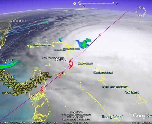
Squarethecircle wrote: Are we looking at the same storm here? The visible looks great to me, and I don't see how the center is to the Southwest. And there is never a zero percent chance... Can someone explain to me what I'm obviously not seeing (no sarcasm intended; this is serious).
That is kinda the question I am asking: Are we looking at the same storm?
From the 5pm discussion: THE AIRCRAFT ALSO REPORTED THAT THE LOW-LEVEL
CENTER WAS BECOMING DISTORTED AND ELONGATED SOUTHWEST TO NORTHEAST...SIGNALING THE
START OF EXTRATROPICAL TRANSITION.
That is clearly visible on the visible satellite imagery. Clouds SW of the center are moving south...they should be moving se...the center is clearly becoming elongated SW-NE like the recon data shows.
As far as a 0 % chance...yes there is. There are many 0% chances. When a 40kt storm has no convection and is getting sheared...there is a 0% chance it will become a hurricane in 3 hours. In this case...I stated why i didn't think it would become a hurricane. If it does become one...it will be done under "other than classic tropical" conditions. In other words...it will be because it is undergoing ET transition and not because the center is embedded in deep convection and great outflow...which is how it usually works. And if it does become a hurricane...it will be extratropical very soon and will be a hurricane for about 12 hours before it is labeled ET.
0 likes
Re: Tropical Storm NOEL Recon Obs
24.8 78.7 is where i posted earlier there was a low level center/swirl that was noticeable on visible loop around 2 pm, and also responsible for the falling pressure's at settlement point bahamas, and lake worth florida after rising earlier in the morning. i think it may be the old LLC from last nite, before the main center reformed around 11pm last nite. ( or perhaps someting stranger)
Last edited by cpdaman on Thu Nov 01, 2007 5:42 pm, edited 1 time in total.
0 likes
-
Derek Ortt
-
CrazyC83
- Professional-Met
- Posts: 34315
- Joined: Tue Mar 07, 2006 11:57 pm
- Location: Deep South, for the first time!
URNT15 KNHC 012239
AF306 1216A NOEL HDOB 18 20071101
222730 2424N 07823W 8428 01476 9986 +171 +162 353042 043 006 001 00
222800 2422N 07824W 8428 01476 9987 +171 +171 352039 040 006 002 00
222830 2421N 07825W 8435 01472 9991 +170 +170 349036 037 003 003 03
222900 2421N 07827W 8427 01481 9991 +170 +170 355037 038 999 999 03
222930 2422N 07827W 8430 01479 9989 +175 +160 357038 038 999 999 03
223000 2423N 07826W 8424 01482 9986 +177 +155 354036 037 005 003 00
223030 2424N 07825W 8431 01474 9986 +175 +155 356035 035 002 004 00
223100 2425N 07824W 8429 01475 9986 +175 +157 357036 036 003 003 00
223130 2426N 07823W 8428 01475 9985 +175 +166 359035 036 008 003 00
223200 2427N 07821W 8430 01472 9982 +175 +162 359034 035 013 002 00
223230 2428N 07820W 8428 01473 9981 +175 +161 000034 034 018 003 00
223300 2429N 07819W 8430 01471 9980 +178 +156 001034 034 023 002 03
223330 2430N 07818W 8430 01458 9966 +180 +154 358033 034 999 999 03
223400 2431N 07817W 8428 01465 9972 +178 +160 354033 033 999 999 03
223430 2432N 07816W 8429 01469 9976 +175 +164 352032 032 999 999 03
223500 2433N 07815W 8428 01467 9977 +172 +164 352032 033 999 999 03
223530 2434N 07814W 8429 01468 9970 +173 +166 351031 032 999 999 03
223600 2435N 07812W 8429 01464 9973 +170 +166 350030 031 999 999 03
223630 2436N 07811W 8427 01468 9975 +167 +167 349029 030 999 999 03
223700 2437N 07810W 8430 01464 9973 +169 +168 350031 031 999 999 03
$$
;
43 kt FL, 997mb - SW quad
0 likes
-
CrazyC83
- Professional-Met
- Posts: 34315
- Joined: Tue Mar 07, 2006 11:57 pm
- Location: Deep South, for the first time!
Re:
Derek Ortt wrote:How long do you think the transition will take?
The models are keeping it in that in between category until landfall (asymmetric warm core). I remember that Wilma took forever and a day to transition (started prior to Florida landfall and took about 2 days and a landfall to complete it)
Something similar. Wilma had to be one of the strongest partially-extratropical storms I can remember (almost made it to Cat 4 after re-emerging over water)
0 likes
-
Air Force Met
- Military Met
- Posts: 4372
- Age: 57
- Joined: Tue Jul 08, 2003 9:30 am
- Location: Roan Mountain, TN
Re:
Derek Ortt wrote:How long do you think the transition will take?
The models are keeping it in that in between category until landfall (asymmetric warm core). I remember that Wilma took forever and a day to transition (started prior to Florida landfall and took about 2 days and a landfall to complete it)
Realistically or how long until the NHC hands it off to the HPC as ET?
Those are two different questions and I may know the answer to the first somewhat...but the second? I haven't a clue.
It looks like ETT will take about 24 hours...considering the elongation of the LLC right now. Its getting butchered. Its also starting to get a tail...
0 likes
-
CrazyC83
- Professional-Met
- Posts: 34315
- Joined: Tue Mar 07, 2006 11:57 pm
- Location: Deep South, for the first time!
URNT15 KNHC 012249
AF306 1216A NOEL HDOB 19 20071101
223730 2439N 07809W 8430 01454 9961 +176 +166 351032 033 999 999 03
223800 2440N 07808W 8428 01455 9966 +177 +166 350033 033 999 999 03
223830 2441N 07807W 8428 01452 9965 +175 +167 348032 032 999 999 03
223900 2442N 07806W 8428 01452 9961 +172 +168 346031 031 999 999 03
223930 2443N 07804W 8430 01451 9964 +169 +169 346031 031 999 999 03
224000 2444N 07803W 8428 01451 9966 +165 +165 344031 031 999 999 03
224030 2445N 07802W 8428 01451 9967 +168 +168 346030 030 999 999 03
224100 2446N 07801W 8428 01472 9966 +172 +168 348029 030 999 999 03
224130 2447N 07800W 8430 01455 9970 +174 +166 346031 031 999 999 03
224200 2448N 07759W 8428 01477 9978 +172 +168 344031 031 999 999 03
224230 2449N 07757W 8428 01461 9966 +173 +168 343031 032 999 999 03
224300 2450N 07756W 8430 01455 9968 +173 +171 343032 033 999 999 03
224330 2452N 07755W 8430 01473 9975 +174 +174 349031 032 118 001 03
224400 2453N 07754W 8427 01467 9971 +175 +174 350031 032 064 000 00
224430 2454N 07753W 8430 01465 9973 +175 +170 351031 031 032 001 00
224500 2455N 07752W 8431 01464 9973 +177 +170 349032 033 029 002 00
224530 2456N 07750W 8428 01467 9973 +179 +168 348032 032 029 002 00
224600 2457N 07749W 8431 01465 9970 +182 +166 345031 031 029 002 00
224630 2458N 07748W 8430 01464 9968 +185 +165 344030 031 030 002 00
224700 2459N 07747W 8428 01464 9968 +184 +165 342029 029 030 003 00
$$
;
996mb now.
0 likes
Re: Tropical Storm NOEL : Discussions & Images
the LLC is elongated all the way back to 24.6 78.2 996.1 mb it would appear
0 likes
Who is online
Users browsing this forum: No registered users and 57 guests