 The posts in this forum are NOT official forecast and should not be used as such. They are just the opinion of the poster and may or may not be backed by sound meteorological data. They are NOT endorsed by any professional institution or

First freeze in 2006:
Boston: November 21
New York City: December 4
Philadelphia: November 4
Washington, DC (DCA): November 4
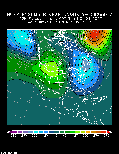
The latest ensemble guidance has been remarkably good in its run-to-run continuity. The latest runs of the GFS and ECMWF are in reasonable agreement, as well. The following is the forecast 500 mb height anomalies forecast at 192 hours by the NCEP ensemble suite:
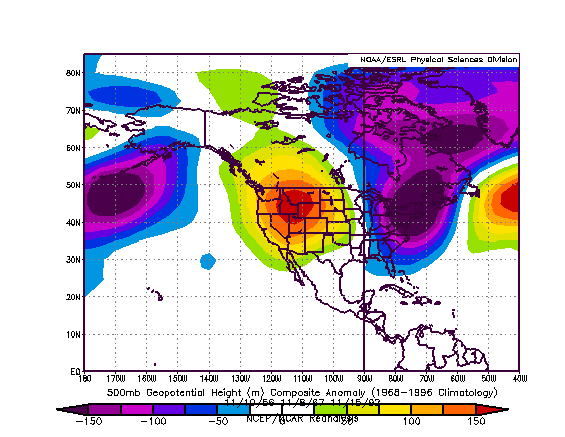
Those anomalies are reasonably similar to a composite from 1956, 1967, and 1992:
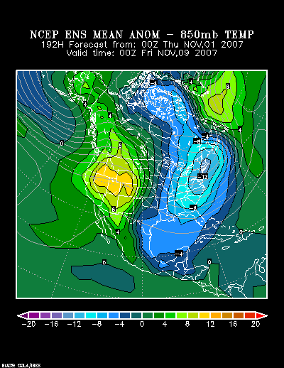
The forecast 850 mb temperature anomalies show an area of unseasonably cold air encompassing the East at 192 hours:
If one examines the individual outbreaks that comprise the composite case, one finds:
Lowest Readings:
November 9-10, 1956:
Boston: 26°
Burlington: 19°
New York City: 30°
Philadelphia: 30°
Toronto: 17° (-8.3°C)
Washington, DC (DCA): 35°
November 5-9, 1967:
Boston: 30°
Burlington: 19°
New York City: 32°
Philadelphia: 28°
Toronto: 24° (-4.4°C)
Washington, DC (DCA): 26°
November 14-16, 1992:
Boston: 30°
Burlington: 21°
New York City: 30°
Philadelphia: 28°
Toronto: 21° (-6.1°C)
Washington, DC (DCA): 27°
Summary:
The November 6-13 period will likely see Boston, New York City, Philadelphia and Washington, DC (DCA) see their lowest readings bottom out at 32° or below. Dulles International Airport (IAD) will probably see its lowest reading in the 20s. Burlington and Toronto should see the lowest reading fall to 22° (-5.6°C) or below. One or more readings of 19° (-7.2°C) or lower are possible in Burlington and Toronto.
Two additional tidbits from the composite cases: In all three cases on which the composite pattern was based, Burlington had seen some accumulation of snow during the cold period. Moreover, at the height of the cold, both Toronto and Burlington had at least one day on which their high temperature reached no higher than 38° (3.3°C).


 I don't think I own a long sleeve anything. LOL To me 50 degrees in the daytime is downright cold.
