The posts in this forum are NOT official forecast and should not be used as such. They are just the opinion of the poster and may or may not be backed by sound meteorological data. They are NOT endorsed by any professional institution or

Nevertheless, the latest computer guidance is now hinting at perhaps the start of the long-dreaded warmth of La Niña. In fact, when one rolls ahead the composite Superensemble analogs centered around 12/15, there are hints of a regime change in the East that could be as spectacular as it would be unwelcome among winter weather lovers.
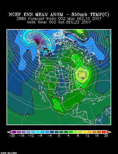
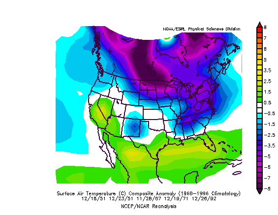
Composite temperature anomalies centered around 12/15:
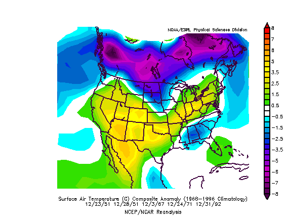
Composite temperature anomalies centered around 12/15: Rolled ahead 5 days:
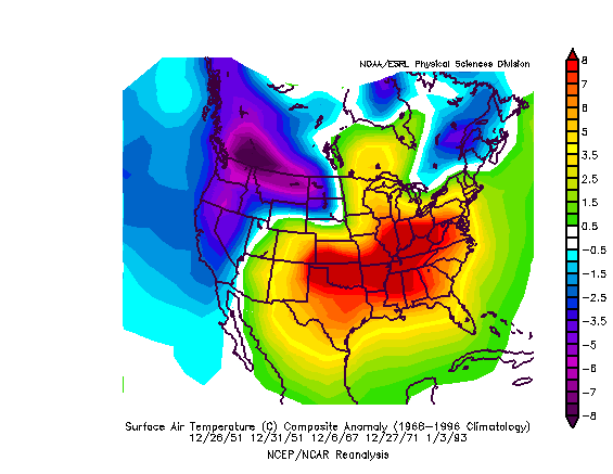
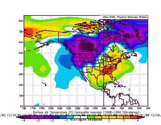
Composite temperature anomalies centered around 12/15: Rolled ahead 8 days:
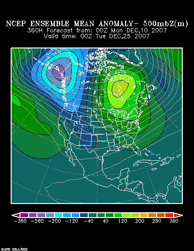
The same holds true if one takes the composite based on the Canadian, ECMWF, 0z GFS, and Superensemble objective analogs centered around 12/15 and rolls them forward 8 days:
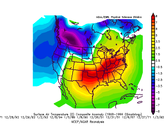
At this time, I do not believe the period as a whole will wind up with such large warm anomalies as might be implied by the 12/23 composite.
In any case, by 12/23 in the composite maps, the warmth in the East had locked in. Consequently, the overwhelming majority of the subsequent 30 days featured above normal temperatures. Is this a hint that the La Niña is ready to seize control of the prevailing patterns? Time will tell.
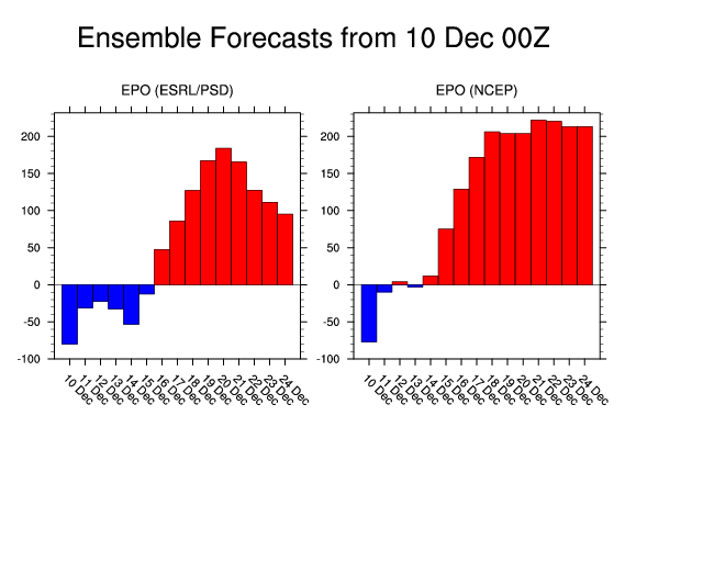
A look at the teleconnection indices offers little comfort from the idea of an gathering storm of warmth. The latest ensemble guidance indicates that the EPO will likely become positive by the 12/19-26 period and that the PNA could tank. The Arctic Oscillation is forecast to rise to around +1 to +2. Worse, a number of these signals have persisted for several days on the ensembles. That kind of setup would favor ridging in the East and a generally wintry arrangement for the Pacific Northwest where winter has been a rare visitor in recent years.
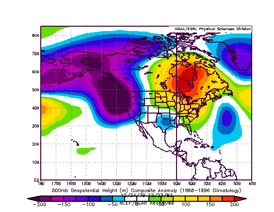
During the 12/16-31 period during the 1971-2000 base period, an AO of +1 to +2 coupled with a PNA < 0 yielded the following composite temperature anomalies:
Those anomalies match up reasonably well in terms of the location of cold and warm anomalies with those produced by the objective analog packages cited above.
Finally, the MJO is likely to be shifting from Phase 4 to Phase 5, possibly early in the 12/19-26 timeframe. Phase 5 favors ridging in the East. All said, at this point in time, this convergence of factors leads me to have fairly high confidence that a warmer pattern could predominate in the East during the 12/19-26 period. Such a pattern does not rule out a brief shot of colder air.
During the aforementioned timeframe, although the warmth likely won’t be excessive for the period as a whole, Boston, New York City, and Philadelphia could all see the temperature top out in the lower 50s on one or more days. Washington, DC and Richmond could reach or exceed 60°. A 40° or above reading is possible in such cities as Burlington and Toronto.
The Pacific Northwest down to northern California, Ohio Valley, and Tennessee Valley look to feature above normal precipitation.
Average Regional Temperature Anomalies (12/19-26):
Northeast: Somewhat above normal
Mid-Atlantic: Above normal
Southeast: Above normal
Great Lakes: Somewhat above normal
Northern Plains: Somewhat below normal to near normal
Central Plains: Above normal
Southern Plains: Above normal
Pacific Northwest: Below normal
Southwest/Rest of West Coast: Somewhat below normal to near normal