
...SPECIAL FEATURE...
AN AREA OF SHOWERS AND THUNDERSTORMS HAS BECOME BETTER ORGANIZED
TODAY ABOUT 550 MILES ENE OF PUERTO RICO AND THE LEEWARD
ISLANDS...IN ASSOCIATION WITH A SHARP SURFACE TROUGH EXTENDING
FROM 24N55W 17N58W TO 9N57W AND A LARGE UPPER-LEVEL LOW NEAR
20N58W. THE SYSTEM IS ALREADY PRODUCING GALE FORCE WINDS...
MAINLY TO THE N AND NE OF THE MAIN AREA OF THUNDERSTORMS. THE
SURFACE TROUGH IS MOVING W NEAR 15 KT...AND THIS MOTION IS
EXPECTED TO CONTINUE OVER THE NEXT DAY OR TWO. WATER
TEMPERATURES REMAIN WARM ENOUGH IN THIS AREA TO SUPPORT TROPICAL
CYCLONE FORMATION...AND UPPER-LEVEL WINDS ARE NOT ESPECIALLY
PROHIBITIVE FOR DEVELOPMENT. THIS SYSTEM HAS THE POTENTIAL TO
BECOME A TROPICAL OR SUBTROPICAL STORM DURING THE NEXT 24 HOURS.
INTERESTS IN THE N LEEWARD ISLANDS...THE VIRGIN ISLANDS...PUERTO
RICO...HISPANIOLA...AND THE E BAHAMAS SHOULD MONITOR THE
PROGRESS OF THIS SYSTEM.
OLGA'S remnants : Discussions & Images
Moderator: S2k Moderators
-
cycloneye

- Admin

- Posts: 149276
- Age: 69
- Joined: Thu Oct 10, 2002 10:54 am
- Location: San Juan, Puerto Rico
Re: INVEST 94L Models Thread
518
WHXX01 KWBC 100039
CHGHUR
TROPICAL CYCLONE GUIDANCE MESSAGE
NWS TPC/NATIONAL HURRICANE CENTER MIAMI FL
0039 UTC MON DEC 10 2007
DISCLAIMER...NUMERICAL MODELS ARE SUBJECT TO LARGE ERRORS.
PLEASE REFER TO NHC OFFICIAL FORECASTS FOR TROPICAL CYCLONE
AND SUBTROPICAL CYCLONE INFORMATION.
ATLANTIC OBJECTIVE AIDS FOR
DISTURBANCE INVEST (AL942007) 20071210 0000 UTC
...00 HRS... ...12 HRS... ...24 HRS. .. ...36 HRS...
071210 0000 071210 1200 071211 0000 071211 1200
LAT LON LAT LON LAT LON LAT LON
BAMS 19.2N 59.2W 18.8N 63.0W 18.5N 66.6W 17.8N 70.4W
BAMD 19.2N 59.2W 19.9N 61.0W 20.6N 62.8W 21.0N 64.5W
BAMM 19.2N 59.2W 19.0N 62.0W 19.1N 64.7W 18.8N 67.6W
LBAR 19.2N 59.2W 19.8N 61.2W 20.3N 63.0W 20.5N 64.5W
SHIP 35KTS 35KTS 33KTS 27KTS
DSHP 35KTS 35KTS 33KTS 27KTS
...48 HRS... ...72 HRS... ...96 HRS. .. ..120 HRS...
071212 0000 071213 0000 071214 0000 071215 0000
LAT LON LAT LON LAT LON LAT LON
BAMS 17.5N 74.1W 16.5N 80.7W 14.9N 85.2W 13.6N 88.8W
BAMD 21.2N 66.3W 21.6N 70.7W 22.0N 75.2W 22.2N 77.6W
BAMM 18.4N 71.0W 17.9N 77.1W 17.3N 82.3W 16.4N 87.3W
LBAR 20.3N 66.0W 19.5N 69.8W 18.7N 74.0W 17.7N 78.2W
SHIP 20KTS 0KTS 0KTS 0KTS
DSHP 24KTS 0KTS 0KTS 0KTS
...INITIAL CONDITIONS...
LATCUR = 19.2N LONCUR = 59.2W DIRCUR = 270DEG SPDCUR = 15KT
LATM12 = 19.2N LONM12 = 56.0W DIRM12 = 270DEG SPDM12 = 14KT
LATM24 = 19.1N LONM24 = 54.0W
WNDCUR = 35KT RMAXWD = 40NM WNDM12 = 35KT
CENPRS = 1009MB OUTPRS = 1014MB OUTRAD = 120NM SDEPTH = D
RD34NE = 200NM RD34SE = 0NM RD34SW = 0NM RD34NW = 120NM
0 likes

Re: INVEST 94L Near Northern Leewards : Discussions & Images
Looking better with each passing hour!
0 likes


Re: INVEST 94L Near Northern Leewards : Discussions & Images
This might be silly to ask but does Florida have to be concerned about this? The high north of this is building and is supposed to be with us through out the upcoming week. This looks like a depression already. It has a nice circulation to it.
http://www.ssd.noaa.gov/goes/east/watl/loop-avn.html
http://www.ssd.noaa.gov/goes/east/watl/loop-avn.html
0 likes

Re: INVEST 94L Models Thread
anyone have the plot for this? I mean for after passing Puerto Rico?
0 likes
-
cycloneye
- Admin
- Posts: 149276
- Age: 69
- Joined: Thu Oct 10, 2002 10:54 am
- Location: San Juan, Puerto Rico
Re: INVEST 94L Models Thread
artist wrote:anyone have the plot for this? I mean for after passing Puerto Rico?
The latest has not been updated but here are the tracks in the longer range after PR.
0 likes

Re: INVEST 94L Models Thread
The forecast track is generally west. What do the SST's look like ahead of the storm?
0 likes
Re: INVEST 94L Near Northern Leewards : Discussions & Images
Does this remind us of hurricane Kate back in 1985.
0 likes
Re: INVEST 94L Models Thread
Nimbus wrote:The forecast track is generally west. What do the SST's look like ahead of the storm?
Marginal. The bigger question is shear.
0 likes

Re: INVEST 94L Near Northern Leewards : Discussions & Images
Luis I was just about to post a track of hurricane Kate from 1985, but I like the graphics of your map better.
0 likes
-
HURAKAN

- Professional-Met

- Posts: 46084
- Age: 39
- Joined: Thu May 20, 2004 4:34 pm
- Location: Key West, FL
- Contact:

Hurricane season is officially over, but that does not mean tropical development cannot still occur. With that in mind, AccuWeather.com is keeping a close eye on an area of low pressure northeast of the Virgin Islands. The door for tropical development has been opened since sea surface temperatures are warm enough and winds blowing above the system are not too strong. Regardless of the low becoming a tropical depression, heavy thunderstorms will spread over the Caribbean Islands the next few days.
Story by AccuWeather.com Meteorologist Kristina Baker
http://www.accuweather.com/news-story.a ... &article=3
0 likes

-
brunota2003

- S2K Supporter

- Posts: 9476
- Age: 35
- Joined: Sat Jul 30, 2005 9:56 pm
- Location: Stanton, KY...formerly Havelock, NC
- Contact:
Re: INVEST 94L Near Northern Leewards : Discussions & Images
According to the shear charts from Weatherunderground.com for the next 72 hours, it appears this area will be heading into more favorable conditions than it already has, provided it heads for the Bahamas...anyone have the middle level shear as well? I think this shear map is uper levels only, though it is still quite interesting. SST's are marginal, but as long as the shear remains low, it has a chance.

0 likes
-
cycloneye
- Admin
- Posts: 149276
- Age: 69
- Joined: Thu Oct 10, 2002 10:54 am
- Location: San Juan, Puerto Rico
Re: INVEST 94L Near Northern Leewards : Discussions & Images

NHC just put floater 4 for Puerto Rico.It may not mean anything that they have it,but neverless is interesting that they want to focus here.
http://www.nhc.noaa.gov/satellite.shtml
0 likes

Re: INVEST 94L Near Northern Leewards : Discussions & Images
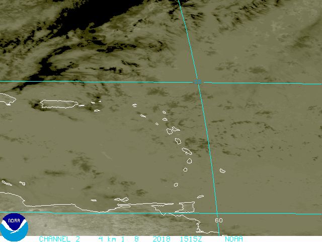
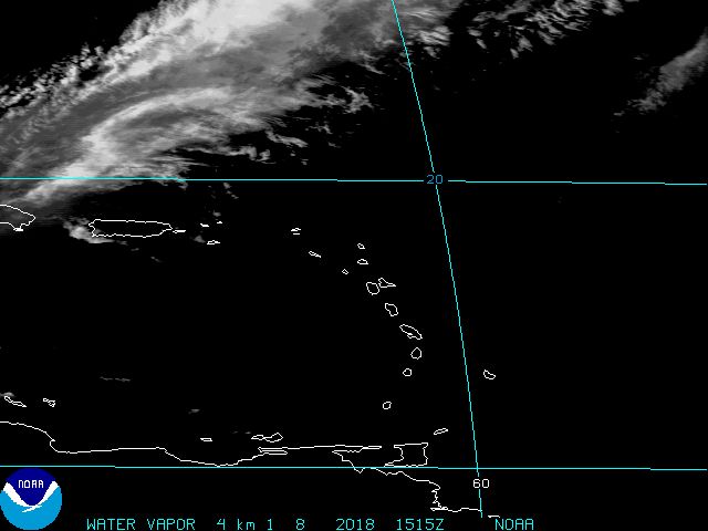
The latest IR imagery from 115utc continues to indicate improvement in the overall structure. I think it's nearing TD status as I post.
0 likes
Re: INVEST 94L Near Northern Leewards : Discussions & Images
The question on my mind is that it is December, once it passes Puerto Rico will it continue west towards Florida. Their are no frontal systems expected in the area until Saturday. Like Vortex stated it looks really good and I think it looks like a depression already.
0 likes
Re: INVEST 94L Near Northern Leewards : Discussions & Images
Here's a map of the SST of the Atlantic.By 94L it looks like its in the upper 70's to around 80°F.
http://www.wunderground.com/tropical/?index_region=at
http://www.wunderground.com/tropical/?index_region=at
0 likes
Who is online
Users browsing this forum: No registered users and 103 guests