 The posts in this forum are NOT official forecast and should not be used as such. They are just the opinion of the poster and may or may not be backed by sound meteorological data. They are NOT endorsed by any professional institution or

To be sure, the EPO is forecast to be strongly positive. The dome of bitter cold air that has been situated over Alaska and northwestern Canada is expected to slide toward Siberia. The Canadian Ensemble mean 10-day forecast anomalies show temperatures running about 0.5 standard deviations above normal across a large chunk of Canada. The objective analogs are quite warm.
Nonetheless, the objective analogs have not proved to be a reliable guide so far this month. Although the idea of a warmer 12/19-26 period still appears reasonable for much of the East albeit without any excessive warmth, the notion that the pattern would lock in still appears suspect. The recent excessive snows across parts of the Great Lakes region, southern Canada, and central and northern New England will also help blunt the magnitude of the warming.
The Pacific Northwest will likely feature above normal precipitation during the 12/27-31 period.
However, what might be the biggest story is the area of cool SSTAs that has developed off the Mid-Atlantic region (4-week anomaly). That anomaly is now forecast to persist, on average, for the December-February period:
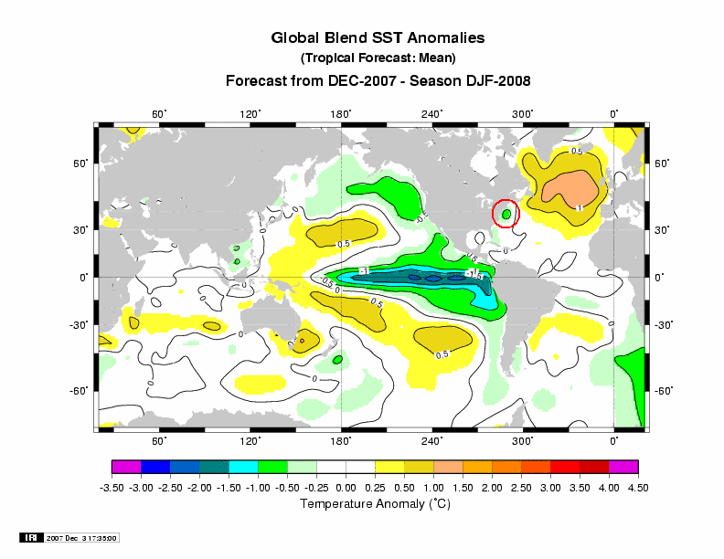
Such situations, when coupled with Cool Pacific SSTAs, have typically featured an area of cooler anomalies in a portion of the East. All 8 winters saw a cool anomaly in part of the East. Those SSTAs might already be playing a role in having promoted a cooler than normal December to date across the Great Lakes region and Northeast. If the experience concerning the SSTAs is representative, warmer winter forecasts (mine included) could face ruin. At this time, that is a possible scenario that bears watching. At least, as a late Hanukkah gift or early Christmas one, there is some reason to maintain hope for a colder idea for parts of the East. The Pacific Northwest remains on track for a good winter.
Finally, during the ongoing La Niña event, cities such as Detroit, Toronto, Ottawa, and Montreal were likely to see above normal snowfall consistent with La Niña climatology. So far, nature has delivered in abundance. Occasionally, moderate or strong La Niña winters have proved snowy in parts of southern New England. One such winter was 1970-71 during which Boston saw 57.3” of snow. Farther south, New York City wound up with just 15.5”.
Through December 16, Boston has picked up 19.6” of snow. Since 1891-92, Boston has had 22 winters with 15” or more snowfall in the October-December period. 21/22 (96%) went on to receive 40” or more of snow and 17/22 (77%) received 50” or more. The mean January-May snowfall for those 22 seasons amounted to 39.4” with a standard deviation of 14.3”. As a result, if Winter 2007-08 falls within a standard deviation of the mean for the 22 aforementioned winters, Boston could expect to pick up an additional 25.1” to 53.7” of snow in the January-May period. That would give Boston minimum seasonal snowfall of 44.7”. In short, La Niña or not, a number of Boston’s snowy winters have had a history of producing much above normal snow in the October-December period.
Average Regional Temperature Anomalies:
Northeast: Near normal to somewhat above normal
Mid-Atlantic: Near normal to somewhat above normal
Southeast: Near normal to somewhat above normal
Great Lakes: Near normal to somewhat above normal
Northern Plains: Near normal to somewhat above normal
Central Plains: Near normal
Southern Plains: Somewhat below normal to near normal
Pacific Northwest: Near normal to somewhat above normal
Southwest/Rest of West Coast: Above normal


