TX winter wx thread: Spring-like pattern

Winter Weather Discussion

Moderator: S2k Moderators

Forum rules

The posts in this forum are NOT official forecast and should not be used as such. They are just the opinion of the poster and may or may not be backed by sound meteorological data. They are NOT endorsed by any professional institution or STORM2K.

Help Support Storm2K
Message
Author
Ed Mahmoud

Re: TX winter weather thread: Active weather pattern setting up

#461 Postby Ed Mahmoud » Wed Dec 26, 2007 1:09 pm

Steve wrote:>>I am not really buying the "sliding to the east" scenario quite yet.

Of course you aren't because it means you get no extreme weather. :)

Merry Christmas anyway. It's mild and windy in the bayou sugarcane fields today.

Steve


I hated that when I worked there. Driving down 182 towards New Iberia, behind a farmer in a little 100 hp John Deere tractor, basically a glorified riding mower, hauling two overfilled wagons of cane to the mill at 4 mph with 70 or 80 cars backed up behind him.
0 likes   

User avatar
Extremeweatherguy
Category 5
Category 5
Posts: 11095
Joined: Mon Oct 10, 2005 8:13 pm
Location: Florida

Re: TX winter weather thread: Active weather pattern setting up

#462 Postby Extremeweatherguy » Wed Dec 26, 2007 1:11 pm

Steve wrote:>>I am not really buying the "sliding to the east" scenario quite yet.

Of course you aren't because it means you get no extreme weather. :)

Merry Christmas anyway. It's mild and windy in the bayou sugarcane fields today.

Steve
Well, yes, of course! lol. And that would go completely against my screen name.

In all seriousness though, I do think my reasoning has some merit, and we will see what happens with the models in the days to come. Even if we do not get an arctic blast, a good freeze or two looks likely. All in all, some nice typical winter weather.
0 likes   

User avatar
vbhoutex
Storm2k Executive
Storm2k Executive
Posts: 29112
Age: 73
Joined: Wed Oct 09, 2002 11:31 pm
Location: Cypress, TX
Contact:

Re: TX winter weather thread: Active weather pattern setting up

#463 Postby vbhoutex » Wed Dec 26, 2007 1:21 pm

I don't even see any freezes with anything in the near future. In fact it appears to me we could be moving back into a more zonal pattern(yes I know that is weird for this time of year), at least in our area. While the models were showing an extended time of freezing temps only a day or so ago, they seem to have backed off from that for our area and are giving the cold to our neighbors to the East. Such is life on the Gulf Coast of Texas.
0 likes   

User avatar
Diva
S2K Supporter
S2K Supporter
Posts: 205
Joined: Fri Jun 16, 2006 11:46 am
Location: Orange, TX

Re: TX winter weather thread: Active weather pattern setting up

#464 Postby Diva » Wed Dec 26, 2007 1:55 pm

vbhoutex wrote:I don't even see any freezes with anything in the near future. In fact it appears to me we could be moving back into a more zonal pattern(yes I know that is weird for this time of year), at least in our area. While the models were showing an extended time of freezing temps only a day or so ago, they seem to have backed off from that for our area and are giving the cold to our neighbors to the East. Such is life on the Gulf Coast of Texas.


:(
0 likes   

User avatar
southerngale
Retired Staff
Retired Staff
Posts: 27418
Joined: Thu Oct 10, 2002 1:27 am
Location: Southeast Texas (Beaumont area)

Re: TX winter weather thread: Active weather pattern setting up

#465 Postby southerngale » Wed Dec 26, 2007 2:00 pm

Extremeweatherguy wrote:
Steve wrote:>>I am not really buying the "sliding to the east" scenario quite yet.

Of course you aren't because it means you get no extreme weather. :)

Merry Christmas anyway. It's mild and windy in the bayou sugarcane fields today.

Steve
Well, yes, of course! lol. And that would go completely against my screen name.

In all seriousness though, I do think my reasoning has some merit, and we will see what happens with the models in the days to come. Even if we do not get an arctic blast, a good freeze or two looks likely. All in all, some nice typical winter weather.


We've had several freezes this week though, so a good freeze or two isn't exactly a big deal. Last night was finally above freezing... bottoming out at a *balmy* 41° before the temps started to slowly rise.

I'm all for the kind of cold that can bring me some snow on the ground for a few days, but I just don't see it happening.
0 likes   

User avatar
weatherrabbit_tx
Category 1
Category 1
Posts: 270
Joined: Wed Dec 21, 2005 3:13 pm
Location: Kingwood,Tx
Contact:

Re: TX winter weather thread: Active weather pattern setting up

#466 Postby weatherrabbit_tx » Wed Dec 26, 2007 3:06 pm

Diva wrote:
vbhoutex wrote:I don't even see any freezes with anything in the near future. In fact it appears to me we could be moving back into a more zonal pattern(yes I know that is weird for this time of year), at least in our area. While the models were showing an extended time of freezing temps only a day or so ago, they seem to have backed off from that for our area and are giving the cold to our neighbors to the East. Such is life on the Gulf Coast of Texas.


:(


I do agree D, :(
0 likes   

User avatar
Extremeweatherguy
Category 5
Category 5
Posts: 11095
Joined: Mon Oct 10, 2005 8:13 pm
Location: Florida

Re: TX winter weather thread: Active weather pattern setting up

#467 Postby Extremeweatherguy » Wed Dec 26, 2007 3:18 pm

I do see below freezing temperatures in the near future. While we likely will not get the major cold snap (with teens) as first thought, we could still easily see lows into the upper 20s and lower 30s for a couple of nights next week. This front will still be very strong..even if the bulk of the cold misses us.

BTW - - With us being still about 6 to 7 days out, I do not think we should write this off so soon either. Only 2 runs of the GFS have trended warmer. Before then, most of the runs were bitter cold. Let's wait for a few more "warmer" runs before saying that this will only be a minor event. The 18z will begin running in a little over 1 hour and should be done in about 2 hours. It will be interesting to see what it shows.
0 likes   

User avatar
Extremeweatherguy
Category 5
Category 5
Posts: 11095
Joined: Mon Oct 10, 2005 8:13 pm
Location: Florida

#468 Postby Extremeweatherguy » Wed Dec 26, 2007 4:39 pm

From the Houston NWS AFD...

THE SOUTHERLY FLOW SHOULD COME
TO AN END EITHER EARLY MONDAY MORNING OR IN THE AFTERNOON. AN
AMPLIFIED UPPER PATTERN WITH RIDGING OVER THE WEST SHOULD SHIFT
EAST AND A DEEPENING TROUGH OVER THE EAST SHOULD DRIVE A VERY COLD
CANADIAN AIRMASS DOWN INTO THE MS VALLEY...WE SHOULD BE ON THE
WESTERN LIMB AND ONLY GET A GLANCING BLOW OF CAA BUT ENOUGH FOR
SOME DECENT WIND. MAY FLIRT WITH THE COLDEST TEMPS THIS SEASON
TUESDAY AND WEDNESDAY MORNING. GUIDANCE CURRENTLY INDICATING A
1043 OR 1046 MB HIGH OVER SE TX/S TX 06Z WEDNESDAY. HAVE UNDERCUT
THE 12Z MEX NUMBERS BY A FEW DEGREES AT A MINIMUM FOR THIS.
0 likes   

User avatar
Extremeweatherguy
Category 5
Category 5
Posts: 11095
Joined: Mon Oct 10, 2005 8:13 pm
Location: Florida

#469 Postby Extremeweatherguy » Wed Dec 26, 2007 6:42 pm

The 18z GFS is now once again much colder than the 6z and 12z and shows the potential for a day or two with sub-50F high temperatures and the possibility of a hard freeze or two here in the Houston area (with it being even colder further north in the state). It also once again knocks our 850mb temperatures down to well below 0C during the event: http://www.nco.ncep.noaa.gov/pmb/nwprod ... p_162l.gif

This is not quite as cold as some of the scenarios from yesterday (which showed setups capable of bringing us teens in SE Texas), but this is also not nearly as warm as the earlier scenarios we saw today. A situation such as what the 18z depicts would mean a cold, dry weather pattern for 2-4 days with the threat of a couple long-duration nighttime hard freezes (<27F) here in SE Texas next week.
0 likes   

User avatar
amawea
S2K Supporter
S2K Supporter
Posts: 385
Age: 73
Joined: Mon Aug 09, 2004 3:36 pm
Location: Horseshoe Bend, Ar. but from Baytown, Tx

Re: TX winter weather thread: Arctic front for New Year's?

#470 Postby amawea » Wed Dec 26, 2007 11:14 pm

We want SNOW!!!! We want SNOW!!! We Want SNOW!!!

SNOW!!!!!!!!!!!!!!!!!!!!!!!!!!!!!!!!!!!!!!!!!!!!!!!!!!!!!!!!!!!!!!!!!!!!

:lol:
:cry:
:wink:
0 likes   

User avatar
Extremeweatherguy
Category 5
Category 5
Posts: 11095
Joined: Mon Oct 10, 2005 8:13 pm
Location: Florida

#471 Postby Extremeweatherguy » Wed Dec 26, 2007 11:38 pm

The 00z GFS continues the trend back toward a colder scenario, and in fact, it now once again is showing a 1050mb+ high pressure system over the rockies (similar to some of the more extreme runs from yesterday). It definitely looks like it will get cold next week if this is correct!

Front first arrives on New Year's Eve: http://www.nco.ncep.noaa.gov/pmb/nwprod/analysis/namer/gfs/00/images/gfs_ten_114l.gif

The high pressure area strengthens on the 1st and even more cold air is pumped into the region: (500mb flow = http://www.nco.ncep.noaa.gov/pmb/nwprod/analysis/namer/gfs/00/images/gfs_500_138l.gif , 850mb temperatures = http://www.nco.ncep.noaa.gov/pmb/nwprod/analysis/namer/gfs/00/images/gfs_pcp_138l.gif )

By the morning of January 2nd, it looks like most of the state will be experiencing a widespread freeze as a 1048mb+ high over the TX panhandle region continues to push cold air into the region: (Surface temperatures = http://www.nco.ncep.noaa.gov/pmb/nwprod/analysis/namer/gfs/00/images/gfs_ten_156l.gif , 850mb temperatures = http://www.nco.ncep.noaa.gov/pmb/nwprod/analysis/namer/gfs/00/images/gfs_pcp_156l.gif )

High temperatures on the afternoon of the 2nd then go on to look very cold (even with sunshine). Highs in the 40s may be felt as far south as Corpus Christi and up in north Texas highs may struggle to get out of the 30s. For the Houston area, we will probably only top out in the low to mid 40s: http://www.nco.ncep.noaa.gov/pmb/nwprod/analysis/namer/gfs/00/images/gfs_ten_162l.gif

The morning of the 3rd then looks very cold with another widespread freeze across the state: http://www.nco.ncep.noaa.gov/pmb/nwprod/analysis/namer/gfs/00/images/gfs_ten_180l.gif
0 likes   

User avatar
vbhoutex
Storm2k Executive
Storm2k Executive
Posts: 29112
Age: 73
Joined: Wed Oct 09, 2002 11:31 pm
Location: Cypress, TX
Contact:

Re: TX winter weather thread: Arctic front for New Year's?

#472 Postby vbhoutex » Thu Dec 27, 2007 12:17 am

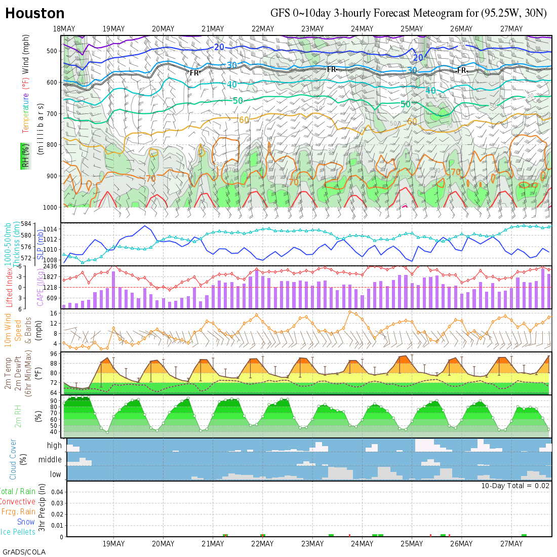
Your interpretation is a lot colder than what the meteogram for the same time period shows.

Image
0 likes   

User avatar
Extremeweatherguy
Category 5
Category 5
Posts: 11095
Joined: Mon Oct 10, 2005 8:13 pm
Location: Florida

#473 Postby Extremeweatherguy » Thu Dec 27, 2007 1:04 am

Is that the 00z meteogram vbhoutex? Because I just went back and re-checked the surface temperature text output for next week, and my interpretation is right on par with what the run is showing. The 00z run shows below freezing temperatures at IAH during the mornings of January 2nd and January 3rd, and it also shows some very chilly high temperatures. On the 1st of January, the model shows IAH struggling to get out of the lower 50s, and on the 2nd it shows us struggling to get out of the lower to middle 40s (with sunshine).

I do think the GFS is probably underestimating the lows though. It is only showing temperatures at IAH getting down to near 30F during this event. However, the 1044mb high overhead, the calm winds, the clear skies, the dry air and the cold 850mb temperatures (near -6C at the peak of the event) would all argue toward a much colder number...likely in the middle 20s. There is still time for the model to catch up on this though, and we still have a few days to sort out all the temperature specifics for next week.

A quick update - - I just compared the meteogram to the text output, and I am pretty sure that, as of 12:05am (12/27/07), it is still showing an earlier run. The text data and that image do not currently match up. I do not know if the same will be true by morning, but as of now the posted meteogram does not seem to be representing the 00z GFS run.
0 likes   

User avatar
southerngale
Retired Staff
Retired Staff
Posts: 27418
Joined: Thu Oct 10, 2002 1:27 am
Location: Southeast Texas (Beaumont area)

Re:

#474 Postby southerngale » Thu Dec 27, 2007 2:19 am

Extremeweatherguy wrote:Is that the 00z meteogram vbhoutex? Because I just went back and re-checked the surface temperature text output for next week, and my interpretation is right on par with what the run is showing. The 00z run shows below freezing temperatures at IAH during the mornings of January 2nd and January 3rd, and it also shows some very chilly high temperatures. On the 1st of January, the model shows IAH struggling to get out of the lower 50s, and on the 2nd it shows us struggling to get out of the lower to middle 40s (with sunshine).

I do think the GFS is probably underestimating the lows though. It is only showing temperatures at IAH getting down to near 30F during this event. However, the 1044mb high overhead, the calm winds, the clear skies, the dry air and the cold 850mb temperatures (near -6C at the peak of the event) would all argue toward a much colder number...likely in the middle 20s. There is still time for the model to catch up on this though, and we still have a few days to sort out all the temperature specifics for next week.

A quick update - - I just compared the meteogram to the text output, and I am pretty sure that, as of 12:05am (12/27/07), it is still showing an earlier run. The text data and that image do not currently match up. I do not know if the same will be true by morning, but as of now the posted meteogram does not seem to be representing the 00z GFS run.


No precipitation expected and cold temps, like we've seen on and off so far this year = pretty normal. That's what we've seen for much of this week and this past weekend, as well as part of last week. What event? :P
Am I missing something? I very well could be. It just looks like normal winter weather down here. Mild, cold, mild, cold, mild, cold... I'm waiting for you to post a bunch of runs showing below or near freezing for several days, with precipitation, and with good model consensus. Now that would be an event! 8-) :lol:

I do enjoy reading your posts. Just send me some snow, will ya?
0 likes   

User avatar
vbhoutex
Storm2k Executive
Storm2k Executive
Posts: 29112
Age: 73
Joined: Wed Oct 09, 2002 11:31 pm
Location: Cypress, TX
Contact:

Re: TX winter weather thread: Arctic front for New Year's?

#475 Postby vbhoutex » Thu Dec 27, 2007 6:57 am

It must have been the run before, even though it shouldn't have been at that time. It is now back to showing the cold as you have described it. Currently 34.2ºf here in Spring Branch. A few degrees colder than I expected based on the dew points when I hit the sack last night. :cold:
0 likes   

Ed Mahmoud

Re: TX winter weather thread: Arctic front for New Year's?

#476 Postby Ed Mahmoud » Thu Dec 27, 2007 8:31 am

Scraped a little frost from the car parked with a Houston mailing address and Spring ISD taxes.


Light freezes and frosts are an every year event in the Northern suburbs of Houston, where nothing comes between us and the North Pole but barb wire fences.
0 likes   

User avatar
CaptinCrunch
S2K Supporter
S2K Supporter
Posts: 8728
Age: 57
Joined: Mon Nov 03, 2003 4:33 pm
Location: Kennedale, TX (Tarrant Co.)

Re: TX winter weather thread: Arctic front for New Year's?

#477 Postby CaptinCrunch » Thu Dec 27, 2007 9:04 am

12-27-07
NWS FTW TX MORNING AFD

STILL LOOKS LIKE A SHOT OF MUCH COLDER AIR WILL MAKE IT INTO NORTH TEXAS
FOR EARLY NEXT WEEK. FRONT WILL SLIDE INTO THE AREA SOMETIME ON
MONDAY WITH COLD ADVECTION CONTINUING INTO TUESDAY WHERE HIGHS
WILL STRUGGLE TO REACH THE MID 40S. WIDESPREAD OVERNIGHT LOWS IN
THE LOW TO MID 20S CAN BE EXPECTED BY WEDNESDAY MORNING.
0 likes   

pwrdog
Tropical Storm
Tropical Storm
Posts: 193
Joined: Fri Jan 26, 2007 5:58 am
Location: Texas

Re: TX winter weather thread: Arctic front for New Year's?

#478 Postby pwrdog » Thu Dec 27, 2007 9:24 am

CaptinCrunch wrote:12-27-07
NWS FTW TX MORNING AFD

STILL LOOKS LIKE A SHOT OF MUCH COLDER AIR WILL MAKE IT INTO NORTH TEXAS
FOR EARLY NEXT WEEK. FRONT WILL SLIDE INTO THE AREA SOMETIME ON
MONDAY WITH COLD ADVECTION CONTINUING INTO TUESDAY WHERE HIGHS
WILL STRUGGLE TO REACH THE MID 40S. WIDESPREAD OVERNIGHT LOWS IN
THE LOW TO MID 20S CAN BE EXPECTED BY WEDNESDAY MORNING.


Clear skies would mean temps falling into the upper teens or lower in Dallas if temps struggle to reach mid 40's once the wind dies down...... It's sure looking more like a 41-16 type day instead of a 45-23 type day.. If the 1050 or so is correct..
0 likes   

User avatar
Extremeweatherguy
Category 5
Category 5
Posts: 11095
Joined: Mon Oct 10, 2005 8:13 pm
Location: Florida

#479 Postby Extremeweatherguy » Thu Dec 27, 2007 11:36 am

12z GFS continues to show a strong high fluctuating between 1047-1052mb next week and is still pushing a strong front through the region...

On January 1st, it shows highs near or below 50F from I-10 northward with 30s likely in parts of north Texas and especially the panhandle (Under mostly sunny skies) = http://www.nco.ncep.noaa.gov/pmb/nwprod/analysis/namer/gfs/12/images/gfs_ten_126l.gif

On the morning of January 2nd, it shows a 1043mb+ high sitting right overhead with below 0C 850mb temperatures and light winds/clear skies. Because of this, I think the current 2m temperature output is probably wrong. The actual surface freezing line would likely extend much further south into the state = http://www.nco.ncep.noaa.gov/pmb/nwprod/analysis/namer/gfs/12/images/gfs_ten_144l.gif , http://www.nco.ncep.noaa.gov/pmb/nwprod/analysis/namer/gfs/12/images/gfs_pcp_144l.gif

The afternoon of the 2nd features highs in the 40s down to Matagorda and highs likely only in the 30s for parts of northern Texas = http://www.nco.ncep.noaa.gov/pmb/nwprod/analysis/namer/gfs/12/images/gfs_ten_150l.gif

The morning of the 3rd features another widespread freeze threat = http://www.nco.ncep.noaa.gov/pmb/nwprod/analysis/namer/gfs/12/images/gfs_ten_168l.gif

**Overall this run is still cold, but like yesterday's 12z, it has decided to move the trough/ridge position slightly further east. This means that while chilly, it is certainly not as cold as it could be if the trough was further west. It will be interesting to see if the 18z and 00z trend back westward like they did yesterday.**

BTW - The one thing that interests me most about this run is the piece of energy (ULL?) it is trying to develop near the SW United States. Over the past few runs, this has continued to show up more and more, and if the trend continues and the possible ULL becomes strong enough in future model output, then it might be what is needed to produce a chance of precipitation. That would definitely be an interesting scenario were it to happen, because the precipitation would most likely be of a wintery variety in many areas. (http://www.nco.ncep.noaa.gov/pmb/nwprod/analysis/namer/gfs/12/images/gfs_500_144l.gif , http://www.nco.ncep.noaa.gov/pmb/nwprod/analysis/namer/gfs/12/images/gfs_500_150l.gif , http://www.nco.ncep.noaa.gov/pmb/nwprod/analysis/namer/gfs/12/images/gfs_500_156l.gif , http://www.nco.ncep.noaa.gov/pmb/nwprod/analysis/namer/gfs/12/images/gfs_500_162l.gif , http://www.nco.ncep.noaa.gov/pmb/nwprod/analysis/namer/gfs/12/images/gfs_500_168l.gif)
0 likes   

User avatar
Portastorm
Storm2k Moderator
Storm2k Moderator
Posts: 9914
Age: 63
Joined: Fri Jul 11, 2003 9:16 am
Location: Round Rock, TX
Contact:

Re: TX winter weather thread: Arctic front for New Year's?

#480 Postby Portastorm » Thu Dec 27, 2007 12:14 pm

EWG, nice job on analyzing the 12z GFS run! I would concur with the bulk of your post! :D

I didn't notice the upper level energy in the 500mb flow until you pointed that out! I'm a little skeptical though and here's why:

1) Wouldn't really fit the pattern as high pressure is building in the Southwest unless it's some energy coming down the northwest flow.

2) ... and then you'd need some moisture at the 850mb level from either the Pacific or Gulf to have anything to get excited about and I don't see it. The flow looks to be out of the north and northeast for MOST of the state with just a southeast flow impacting the coastal regions.

Nevertheless, I don't want to serve up a poo-poo platter on your idea just yet. :wink:

Am going to watch this closely on future runs and will be curious to see what the 12z Euro says.
0 likes   


Return to “Winter Weather”

Who is online

Users browsing this forum: No registered users and 13 guests