Winter Weather in the deep south thread

Winter Weather Discussion

Moderator: S2k Moderators

Forum rules

The posts in this forum are NOT official forecast and should not be used as such. They are just the opinion of the poster and may or may not be backed by sound meteorological data. They are NOT endorsed by any professional institution or STORM2K.

Help Support Storm2K
Message
Author
Ed Mahmoud

Re: New years Snow in the deep south?

#81 Postby Ed Mahmoud » Tue Dec 25, 2007 2:23 pm

¡Que Lastima!

12Z Euro still has a 1040 mb high building into Texas with on going cold air advection.

Image


But, tragically, Northwest flow aloft, not favorable for wintry weather!


Image
0 likes   

Brent
S2K Supporter
S2K Supporter
Posts: 38087
Age: 36
Joined: Sun May 16, 2004 10:30 pm
Location: Tulsa Oklahoma
Contact:

Re: New years Snow in the deep south?

#82 Postby Brent » Tue Dec 25, 2007 4:26 pm

Man today turned out to be a REALLY close call, and it's not over yet. Very cold largely unexpected rain. Was supposed to be pushing 60 with no rain. Instead it's in the upper 30's with rain occasionally mixed with sleet all day, and an upper level low is overhead so some snow mixed in still can't be ruled out. :lol:
0 likes   

User avatar
Ivanhater
Storm2k Moderator
Storm2k Moderator
Posts: 11160
Age: 38
Joined: Fri Jul 01, 2005 8:25 am
Location: Pensacola

Re: New years Snow in the deep south?

#83 Postby Ivanhater » Tue Dec 25, 2007 4:55 pm

Brent wrote:Man today turned out to be a REALLY close call, and it's not over yet. Very cold largely unexpected rain. Was supposed to be pushing 60 with no rain. Instead it's in the upper 30's with rain occasionally mixed with sleet all day, and an upper level low is overhead so some snow mixed in still can't be ruled out. :lol:


Yep Brent..sleet reported in the Florida panhandle today parts of Pensacola and Destin...I was at the beach and Im pretty sure it was hail where i was
0 likes   

User avatar
Ivanhater
Storm2k Moderator
Storm2k Moderator
Posts: 11160
Age: 38
Joined: Fri Jul 01, 2005 8:25 am
Location: Pensacola

Re: New years Snow in the deep south?

#84 Postby Ivanhater » Tue Dec 25, 2007 5:25 pm

18 z rolling in now...trending colder out to 144hrs
0 likes   

User avatar
MGC
S2K Supporter
S2K Supporter
Posts: 5897
Joined: Sun Mar 23, 2003 9:05 pm
Location: Pass Christian MS, or what is left.

Re: New years Snow in the deep south?

#85 Postby MGC » Wed Dec 26, 2007 12:06 am

In today's area forecast discussion from New Orleans......long term, modes appear to set up cross-polar flow...a very cold scenario can be expected headed into the new year....however model confidence is low.

So, it appears the NWS office in New Orleans is keeping an eye on the possiblity of some very cold temperatures in a week or so.....MGC
0 likes   

User avatar
Lowpressure
S2K Supporter
S2K Supporter
Posts: 2032
Age: 58
Joined: Sun Sep 14, 2003 9:17 am
Location: Charlotte, North Carolina

Re: New years Snow in the deep south?

#86 Postby Lowpressure » Wed Dec 26, 2007 8:51 am

Charlotte now mentioning deep low pressure coming middle of next week with significantly lower thicknesses and much cooler temps! Now only 7 days out, starting to be discussed in long range forecast today/tonight.
0 likes   

User avatar
HarlequinBoy
Category 5
Category 5
Posts: 1400
Age: 34
Joined: Wed Nov 29, 2006 1:57 am
Location: Memphis

#87 Postby HarlequinBoy » Wed Dec 26, 2007 11:11 am

AFDs across the South appear confident in a colder regime for sure, and a notable change from yesterday is they're mentioning a more unsettled pattern for next week.. rather than a dry northwest flow.
0 likes   

User avatar
jdray
Category 3
Category 3
Posts: 853
Joined: Tue Aug 31, 2004 10:07 pm
Location: NE Florida

Re: New years Snow in the deep south?

#88 Postby jdray » Wed Dec 26, 2007 11:59 am

000
FXUS62 KJAX 260911
AFDJAX

AREA FORECAST DISCUSSION
NATIONAL WEATHER SERVICE JACKSONVILLE FL
410 AM EST WED DEC 26 2007

.SYNOPSIS...MSAS ANALYSIS SHOWS A 1008 MB LOW PRESSURE CENTER
OFFSHORE OF THE CAROLINAS WITH WEAK TROUGH OVER SE GA ORIENTED
NW-SE. TEMPS ARE IN THE 40S WITH FOG PRODUCT SHOWING MOST OF THE CWA
IN LOW CIGS WITH AREAS OF FOG AND PATCHY DRIZZLE. ALOFT...LOTS OF
DRY AIR INDICATED IN WATER VAPOR IMAGERY AND MID-UPPER LOW IS
LOCATED OVER NRN GA NEWD.

.SHORT TERM (TODAY-FRI)...
FOR TODAY...MODELS ARE SIMILAR SHOWING THE MID-UPPER LEVEL LOW N OF
THE AREA LIFTING NEWD WHICH WILL RESULT IN BUILDING HEIGHTS WITH SFC
HIGH PRESSURE IN CONTROL. THE LOW CLOUDS AND FOG WILL GRADUALLY DISSIPATE
DURING THE DAY DUE TO NVA AND SUBSIDENCE. ANTICIPATE HIGHS FROM UPPER
50S TO UPPER 60S ACROSS THE CWA. TONIGHT...ANOTHER SHORTWAVE TROUGH
MOVES INTO THE LOWER MS VALLEY AREA AND THEN DE-AMPLIFIES WHILE
PUSHING A WEAK COLD FRONT TOWARD THE CWA. INCREASING CIRRUS ALOFT
EXPECTED AND LOWS FROM NEAR 40 IN SE GA TO UPPER 40S OVER SRN ZONES.
PATCHY FOG WILL BE POSSIBLE TOWARD EARLY MORNING WITH VSBY POSSIBLY
DOWN TO 1 TO 2 MILES BRIEFLY. THU...FLOW AT MOST LEVELS WILL BE SW
TO W AS WEAKENING SHORTWAVE TROUGH MOVES THROUGH THE AREA AND UPPER
RIDGE WEAKENS. ALTHOUGH MOISTURE LEVELS DO INCREASE ESPECIALLY FROM
SUWANEE VALLEY INTO SE GA SYNOPTIC LIFT FROM THE FRONT WILL BE
MEAGER AND SO WILL LIKELY ONLY CARRY SILENT POPS. WARM ADVECTION
WILL ALLOW TEMPS TO REACH THE 70S MOST AREAS. THU NIGHT...FRONTAL
BOUNDARY REALLY NEVER MOVES THROUGH AS NEXT IN A SERIES OF SHORTWAVE
TROUGHS MOVES INTO THE CENTRAL U.S. AND ALLOWS UPPER RIDGE TO BUILD
AGAIN OVER THE FORECAST AREA. MOISTURE CONTINUES TO INCREASE OVER
THE AREA MAINLY OVER NW SECTIONS AND WILL CONTINUE WITH SLIGHT POPS.
TEMPS WILL NOT BE AS COOL ...ONLY IN THE 50S. FRIDAY...NEW COLD
FRONT DEVELOPS OVER LOWER AND MID MS VALLEY FRIDAY AND MOVES EWD.
WARM ADVECTION PATTERN CONTINUES AHEAD OF THE FRONT WITH HIGHS FROM
LOWER 70S TO NEAR 80. AT THIS TIME PREFERRED THE LOWER MET POPS WITH
20-30% WITH 30% IN SE GA CLOSER TO DEEPER MOISTURE.

.LONG TERM (SATURDAY-TUESDAY)...SUPPORT FOR THE FRONT WANES WITH
WEAK SHORTWAVE ENERGY LIFTING THROUGH THE AREA. SWATH OF MOISTURE
FROM GULF TO SRN GA WILL KEEP RAIN CHANCES IN THE FORECAST FROM
EARLY SAT THROUGH SUN AS THE FRONT STALLS THEN LIFTS NWD AS WARM
FRONT ON SAT NIGHT. DUE TO UNCERTAINTY WITH LIFT AND TIMING WILL CAP
POPS AT 40%. ON SAT...ONLY SLIGHT CHANCES FOR THUNDERSTORMS DUE TO
LIMITED INSTABILITY WITH SUWANEE VALLEY AND SE GA PROGGED FOR
THUNDER. AT THIS TIME GFS SUGGEST MUCAPE OF ABOUT 1200 J/KG. FRONT
APPEARS TO PUSH THROUGH THE AREA LATE SUN NIGHT AND DRIER AND COOLER
CONDS IN STORE FOR MON AS PRECIP ENDS OVER SE ZONES. COLDER AIRMASS
WILL FILTER INTO THE CENTRAL U.S. EARLY NEXT WEEK AND DIGGING
SHORTWAVE TROUGH MAY HELP INITIATE SFC LOW DEVELOPMENT OVER THE GULF
OF MEXICO. SFC LOW MAY BE JUST S OF THE FORECAST AREA AND INCREASING
MOISTURE AND LIFT EXPECTED TO INCREASE RAIN CHANCES ON TUE BEFORE
THE COLDER AIR ARRIVES BY MID WEEK.


&&

.AVIATION...SURFACE LOW OFF THE CAROLINA COAST AND 700-500 MB
LOW ACROSS NORTH GA THIS MORNING GENERATING WIDESPREAD LOW
CLOUDINESS WITH IFR CIG CONDITIONS. AS BOTH THE SURFACE AND
MID LEVEL LOW LIFT NORTHEAST DRIER AIR WILL FILTER IN AND
GRADUALLY DISSIPATE THE LOW CLOUD DECK. HAVE CONDITIONS IMPROVING
TO VFR AT GNV BY 14Z AND JAX...CRG...SSI BY 15Z.

&&

.MARINE...WINDS/SEAS SLOWLY DECLINING AS SURFACE LOW OFF THE
CAROLINA COAST MOVES NE. SEAS 5-6 FEET BEING REPORTED AT
GRAYS REEF AND R2 TOWER. WILL LET CURRENT SCA EXPIRE AT
5 AM AND THEN ISSUE THE CWF WITH AN EXERCISE CAUTION FOR
THE OFFSHORE. NO HEADLINES EXPECTED AFTER THIS MORNING AS
HIGH PRESSURE BUILDS IN TODAY AND GRADUALLY MOVES OFFSHORE
THE REMAINDER OF THE WEEK.

&&

.PRELIMINARY POINT TEMPS/POPS...
AMG 58 39 69 52 / 0 10 10 20
SSI 59 46 68 56 / 0 0 10 10
JAX 63 42 73 55 / 0 0 10 10
SGJ 63 47 73 59 / 0 0 10 10
GNV 66 42 76 53 / 0 0 10 10
OCF 68 45 77 55 / 0 0 10 10

&&

.JAX WATCHES/WARNINGS/ADVISORIES...
FL...NONE.
GA...NONE.
AM...SMALL CRAFT ADVISORY UNTIL 5 AM EST EARLY THIS MORNING FOR
ALTAMAHA SOUND GA TO FERNANDINA BEACH FL 20 NM TO 60 NM
OFFSHORE.

&&

$$

SHASHY/PETERSON
===========================================================


NWS JAX office is seeing some cold weather coming mid week next week. SFC Low going south of the area will increase precip, possible snow/sleet mix setup coming?

YAY!!!!
0 likes   

Ed Mahmoud

Re: New years Snow in the deep south?

#89 Postby Ed Mahmoud » Wed Dec 26, 2007 12:09 pm

12Z GFS shows -10ºC 850 mb isotherm over JAX this time next week, but sadly, no winter precip of note anywhere.

Image
0 likes   

User avatar
jdray
Category 3
Category 3
Posts: 853
Joined: Tue Aug 31, 2004 10:07 pm
Location: NE Florida

Re: New years Snow in the deep south?

#90 Postby jdray » Wed Dec 26, 2007 4:07 pm

AREA FORECAST DISCUSSION
NATIONAL WEATHER SERVICE JACKSONVILLE FL
235 PM EST WED DEC 26 2007

.LONG TERM...NEXT FRONTAL SYSTEM IS FCST BY THE 12Z GFS TO CROSS
THE AREA LATE MON...FASTER THAN PREVIOUS RUNS AND OTHER GLOBAL
MODELS. THE GFS ALSO FEATURES A 1047 MB HIGH OVER S IA BY WED
MORNING. THIS SCENARIO MAY BE TOO FAST AND COLD...BUT HAVE TWEAKED
TEMPS DOWN A FEW MORE DEGREES ON WED MORNING. IF THE GFS PANS
OUT...THIS MAY BE THE COLDEST OUTBREAK OF THE SEASON SO FAR.
0 likes   

User avatar
Ivanhater
Storm2k Moderator
Storm2k Moderator
Posts: 11160
Age: 38
Joined: Fri Jul 01, 2005 8:25 am
Location: Pensacola

Re: New years Snow in the deep south?

#91 Postby Ivanhater » Wed Dec 26, 2007 5:32 pm

Texas..your back in business!...Also getting some moisture return on this run...
Image
0 likes   

Brent
S2K Supporter
S2K Supporter
Posts: 38087
Age: 36
Joined: Sun May 16, 2004 10:30 pm
Location: Tulsa Oklahoma
Contact:

Re: New years Snow in the deep south?

#92 Postby Brent » Wed Dec 26, 2007 6:40 pm

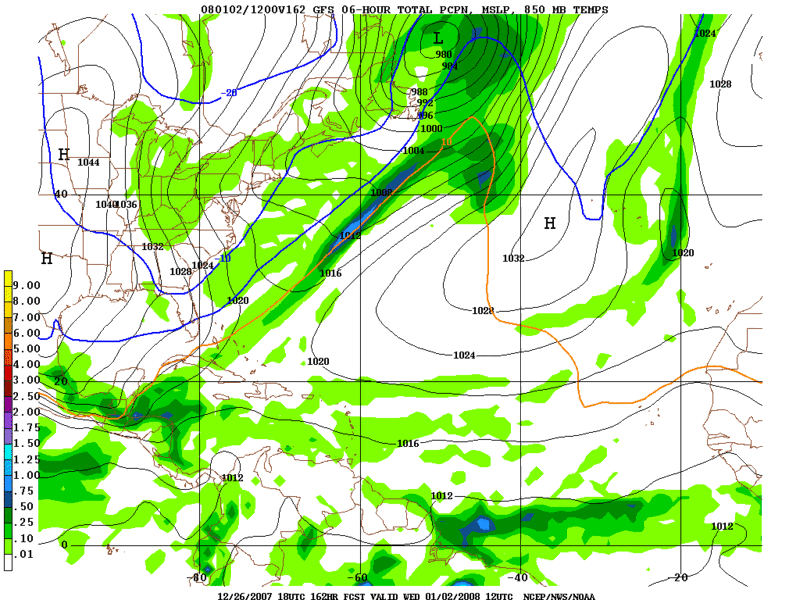
Ivanhater wrote:Texas..your back in business!...Also getting some moisture return on this run...
Image


and snow in Panama City! :P
0 likes   

User avatar
Ivanhater
Storm2k Moderator
Storm2k Moderator
Posts: 11160
Age: 38
Joined: Fri Jul 01, 2005 8:25 am
Location: Pensacola

Re: New years Snow in the deep south?

#93 Postby Ivanhater » Wed Dec 26, 2007 7:59 pm

:cold: :cold:
Image
0 likes   

JonathanBelles
Professional-Met
Professional-Met
Posts: 11430
Age: 35
Joined: Sat Dec 24, 2005 9:00 pm
Location: School: Florida State University (Tallahassee, FL) Home: St. Petersburg, Florida
Contact:

#94 Postby JonathanBelles » Wed Dec 26, 2007 8:01 pm

Are the GFS runs trending cooler or warm? wetter or dryer?

I've only been looking at the images posted here, and at the 0Z runs.
0 likes   

Brent
S2K Supporter
S2K Supporter
Posts: 38087
Age: 36
Joined: Sun May 16, 2004 10:30 pm
Location: Tulsa Oklahoma
Contact:

Re: New years Snow in the deep south?

#95 Postby Brent » Wed Dec 26, 2007 8:08 pm

Ivanhater wrote::cold: :cold:
Image


:crazyeyes: :jacket:
0 likes   

User avatar
Ivanhater
Storm2k Moderator
Storm2k Moderator
Posts: 11160
Age: 38
Joined: Fri Jul 01, 2005 8:25 am
Location: Pensacola

Re:

#96 Postby Ivanhater » Wed Dec 26, 2007 8:13 pm

fact789 wrote:Are the GFS runs trending cooler or warm? wetter or dryer?

I've only been looking at the images posted here, and at the 0Z runs.


Latest run...colder again with slight moisture return showing snow around the Florida panhandle beaches...as for the precip I think its way to early to tell on that..
0 likes   

User avatar
Sean in New Orleans
Category 5
Category 5
Posts: 1794
Joined: Thu Aug 28, 2003 7:26 pm
Location: New Orleans, LA 30.0N 90.0W
Contact:

#97 Postby Sean in New Orleans » Wed Dec 26, 2007 9:31 pm

This is the latest from New Orleans NWS Office:

.LONG TERM...
MOISTURE AGAIN RETURNS NORTHWARD SATURDAY NIGHT. AS ISENTROPIC
LIFT AHEAD OF THAT SYSTEM MOVES IN...CHANCES INCREASE FOR
PRECIPITATION AGAIN FOR SATURDAY NIGHT AND AT LEAST PART OF
SUNDAY. THIS SYSTEM WILL BE TRACKING FURTHER NORTH...AND WE MAY
REMAIN DRY WITH THE ACTUAL FRONTAL PASSAGE SUNDAY NIGHT. THIS
APPEARS TO BE THE LAST PRECIPITATION PRODUCING IMPULSE IN THIS
CYCLE. AFTER MONDAY...FLOW BECOMES NORTHWEST FOR A BRIEF TIME WITH
COLDER TEMPERATURES ON TAP FOR TUESDAY AND POSSIBLY WEDNESDAY. AT
THIS POINT...AIRMASS DOESN`T APPEAR TO BE APPRECIABLY COLDER THAN
WHAT WE HAVE HAD TO THIS POINT.

BEYOND MIDWEEK NEXT WEEK...FLOW FORECAST TO BECOME MORE
ZONAL...WITH COLD AIR BOTTLED UP WELL INTO CANADA. THIS WOULD
PORTEND A DRIER PATTERN WITH ABOVE NORMAL TEMPERATURES FOR OUR
AREA.
&&
0 likes   

JonathanBelles
Professional-Met
Professional-Met
Posts: 11430
Age: 35
Joined: Sat Dec 24, 2005 9:00 pm
Location: School: Florida State University (Tallahassee, FL) Home: St. Petersburg, Florida
Contact:

#98 Postby JonathanBelles » Wed Dec 26, 2007 9:38 pm

what is Isentropic Lift?
0 likes   

rsdoug1981
Tropical Storm
Tropical Storm
Posts: 184
Joined: Tue Aug 31, 2004 4:22 pm
Location: Canton, MS

Re: New years Snow in the deep south?

#99 Postby rsdoug1981 » Wed Dec 26, 2007 9:44 pm

fact789 wrote:what is Isentropic Lift?


Someone correct me if I'm wrong...

Isentropic lift occurs when cooler air wedges itself under warmer air. The warmer air rises, cools below its dewpoint (the point at which air becomes saturated), condenses, and falls as precipitation.
0 likes   

User avatar
boca
Category 5
Category 5
Posts: 6367
Age: 60
Joined: Mon Dec 15, 2003 8:49 am
Location: Boca Raton,FL

Re: New years Snow in the deep south?

#100 Postby boca » Thu Dec 27, 2007 8:58 am

The 850 0 line is south of the Keys again.I'm new at winter weather isotherms temps so what does that mean as far as tempature is for Florida.
http://www.nco.ncep.noaa.gov/pmb/nwprod ... p_162m.gif
0 likes   


Return to “Winter Weather”

Who is online

Users browsing this forum: No registered users and 8 guests