One last hurrah - pulling a Zeta? E. Atlantic

This is the general tropical discussion area. Anyone can take their shot at predicting a storms path.

Moderator: S2k Moderators

Forum rules

The posts in this forum are NOT official forecasts and should not be used as such. They are just the opinion of the poster and may or may not be backed by sound meteorological data. They are NOT endorsed by any professional institution or STORM2K. For official information, please refer to products from the National Hurricane Center and National Weather Service.

Help Support Storm2K
Message
Author
User avatar
Chacor
Category 5
Category 5
Posts: 10229
Joined: Mon Oct 02, 2006 10:43 pm
Location: Singapore

#21 Postby Chacor » Thu Dec 27, 2007 10:01 pm

Image

From 2100Z
0 likes   

CrazyC83
Professional-Met
Professional-Met
Posts: 34001
Joined: Tue Mar 07, 2006 11:57 pm
Location: Deep South, for the first time!

#22 Postby CrazyC83 » Thu Dec 27, 2007 10:14 pm

Looks at least subtropical if not fully tropical to me...well-defined closed circulation, strongest winds close to the center...if this was in season they'd likely have at least declared it an Invest (95L in this case), but they are much more cautious outside the hurricane season. What is the situation of the core, is it warm-core or cold-core?
0 likes   

Coredesat

#23 Postby Coredesat » Thu Dec 27, 2007 10:14 pm

They can't call it subtropical or tropical if it's still being analyzed as frontal.
0 likes   

CrazyC83
Professional-Met
Professional-Met
Posts: 34001
Joined: Tue Mar 07, 2006 11:57 pm
Location: Deep South, for the first time!

Re:

#24 Postby CrazyC83 » Thu Dec 27, 2007 10:18 pm

Coredesat wrote:They can't call it subtropical or tropical if it's still being analyzed as frontal.


It doesn't look frontal according to QuikSCAT...although according to this it has a marginal cold core.
0 likes   

Matt-hurricanewatcher

Re: One last hurrah - pulling a Zeta? (E. Atlantic)

#25 Postby Matt-hurricanewatcher » Fri Dec 28, 2007 1:40 am

Yeah it still has a frontal system on satellite, that you can clearly see. The quickscat shows on the other hand a nice close/tight wind field. We will see if it can stay for the next few days in develop close to that core.

I understand that you want this to be upgraded. In I wish more then most it would develop the convection to be so.
0 likes   

User avatar
HURAKAN
Professional-Met
Professional-Met
Posts: 46086
Age: 38
Joined: Thu May 20, 2004 4:34 pm
Location: Key West, FL
Contact:

Re: One last hurrah - pulling a Zeta? (E. Atlantic)

#26 Postby HURAKAN » Fri Dec 28, 2007 6:15 am

Image
0 likes   

User avatar
HURAKAN
Professional-Met
Professional-Met
Posts: 46086
Age: 38
Joined: Thu May 20, 2004 4:34 pm
Location: Key West, FL
Contact:

#27 Postby HURAKAN » Fri Dec 28, 2007 6:28 am

Image
0 likes   

User avatar
cycloneye
Admin
Admin
Posts: 143865
Age: 68
Joined: Thu Oct 10, 2002 10:54 am
Location: San Juan, Puerto Rico

Re: One last hurrah - pulling a Zeta? (E. Atlantic)

#28 Postby cycloneye » Fri Dec 28, 2007 8:32 am

Image

A little more convection this morning.
0 likes   

Coredesat

#29 Postby Coredesat » Fri Dec 28, 2007 9:19 am

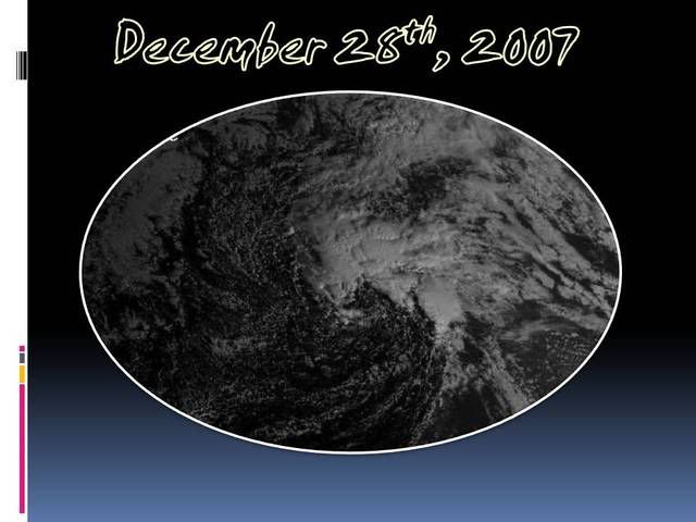
Given how close the stable air is (note the stratocumulus to the NW), this system doesn't have much longer if it wants to become subtropical or tropical.

Image

A DEEP LAYER CYCLONIC
CIRCULATION CENTER REMAINS IN THE CENTRAL ATLANTIC OCEAN NEAR
26N38W ON WATER VAPOR IMAGERY...AND A 1009 MB LOW PRESSURE
CENTER IS NEAR 26N37W ON THE 28/0600 UTC SURFACE MAP ANALYSIS.
THE DEEP LAYER TROUGH RUNS FROM THE 26N37W CYCLONIC CENTER TO
20N45W 15N51W TO 14N60W. ONE SURFACE TROUGH EXTENDS FROM THE
1009 MB LOW CENTER TO 24N35W 17N40W 13N50W 12N55W. A SECOND
SURFACE TROUGH EXTENDS FROM THE LOW CENTER TO 20N40W 18N44W
17N51W. SHOWERS ARE POSSIBLE IN NARROW LINES ALONG EACH TROUGH.
SCATTERED MODERATE SHOWERS TO ISOLATED STRONG THUNDERSTORMS
ARE FROM 24N TO 30N BETWEEN 30W AND 40W.

Based on that, the system is no longer frontal, but is very complex; it has two surface trofs associated with it.
0 likes   

CrazyC83
Professional-Met
Professional-Met
Posts: 34001
Joined: Tue Mar 07, 2006 11:57 pm
Location: Deep South, for the first time!

#30 Postby CrazyC83 » Fri Dec 28, 2007 10:57 am

http://moe.met.fsu.edu/cyclonephase/ukm ... 06/18.html

At 06Z, right on the warm core-cold core line...
0 likes   

User avatar
Chacor
Category 5
Category 5
Posts: 10229
Joined: Mon Oct 02, 2006 10:43 pm
Location: Singapore

#31 Postby Chacor » Fri Dec 28, 2007 11:09 am

Those are MODELS. They do not necessarily accurately reflect the actual situation.
0 likes   

Cyclone1
Category 5
Category 5
Posts: 2739
Age: 33
Joined: Tue Jun 12, 2007 12:03 pm
Location: Florida

#32 Postby Cyclone1 » Fri Dec 28, 2007 11:48 am

Wow, honestly I expected it to be gone or clearly extratropical today.

And it appears to be gettig less extratropical I type.

I still can't see it forming, simply because of how unimaginably low the chances of an Atlantic year to year crossover storm coming only two years after Zeta are.

Rule of Hurricane Tracking: Don't expect the unexpected, just don't count it out.
0 likes   

RL3AO
Moderator-Pro Met
Moderator-Pro Met
Posts: 16308
Joined: Thu Jun 14, 2007 10:03 pm
Location: NC

Re: One last hurrah - pulling a Zeta? (E. Atlantic)

#33 Postby RL3AO » Fri Dec 28, 2007 11:50 am

Go south! I want Arthur! :lol: :roll:
0 likes   

User avatar
HURAKAN
Professional-Met
Professional-Met
Posts: 46086
Age: 38
Joined: Thu May 20, 2004 4:34 pm
Location: Key West, FL
Contact:

#34 Postby HURAKAN » Fri Dec 28, 2007 11:55 am

Image

Loop

Looks very interesting.
0 likes   

Frank2
Category 5
Category 5
Posts: 4061
Joined: Mon Jul 25, 2005 12:47 pm

Re: One last hurrah - pulling a Zeta? (E. Atlantic)

#35 Postby Frank2 » Fri Dec 28, 2007 12:22 pm

It does appear more tropical than yesterday, but, still not quite...
0 likes   

Aric Dunn
Category 5
Category 5
Posts: 21238
Age: 42
Joined: Sun Sep 19, 2004 9:58 pm
Location: Ready for the Chase.
Contact:

Re: One last hurrah - pulling a Zeta? (E. Atlantic)

#36 Postby Aric Dunn » Fri Dec 28, 2007 12:49 pm

Image

this should help on the frontal nature..
gfs brings it to possible subtropical


and of course the CMC is much more bullish with .. has it a full tropical system
Image
0 likes   

User avatar
cycloneye
Admin
Admin
Posts: 143865
Age: 68
Joined: Thu Oct 10, 2002 10:54 am
Location: San Juan, Puerto Rico

Re: One last hurrah - pulling a Zeta? (E. Atlantic)

#37 Postby cycloneye » Fri Dec 28, 2007 1:04 pm

1:05 PM EST Discussion:

A DEEP LAYERED TROUGH REMAINS STUCK OVER
THE CENTRAL ATLANTIC EXTENDING SW FROM A CUT-OFF LOW NEAR 26N38W
TO JUST EAST OF THE WINDWARD ISLANDS. AT THE SURFACE...A 1011 MB
LOW CONTINUES TO MEANDER NEAR 26N38W WITH A TROUGH EXTENDING S
THEN SW TO NEAR TRINIDAD AND TOBAGO. A ROPE CLOUD DEFINES THIS
TROUGH ON VIS SAT IMAGERY. A QUIKSCAT PASS FROM AROUND 1200 UTC
SHOWED VERY CLEAR THE CYCLONIC CIRCULATION. SCATTERED MODERATE
CONVECTION IS WITHIN 120 NM N OF THE LOW CENTER AND WITHIN 75 NM
AHEAD OF THE TROUGH N OF 24N.


http://www.storm2k.org/weather/hw3.php? ... hwvmetric=
0 likes   

User avatar
HURAKAN
Professional-Met
Professional-Met
Posts: 46086
Age: 38
Joined: Thu May 20, 2004 4:34 pm
Location: Key West, FL
Contact:

#38 Postby HURAKAN » Fri Dec 28, 2007 3:40 pm

Image

Image

Image

Beginning to look more subtropical as convection tries to wrap around the LLC. Still, it cannot a be called a subtropical storm. Lets wait another 24 hours to see how it reacts. Nonetheless, it has made a great progress.
0 likes   

CrazyC83
Professional-Met
Professional-Met
Posts: 34001
Joined: Tue Mar 07, 2006 11:57 pm
Location: Deep South, for the first time!

#39 Postby CrazyC83 » Fri Dec 28, 2007 7:23 pm

Models all initialized this as a marginal warm core system...
0 likes   

User avatar
HURAKAN
Professional-Met
Professional-Met
Posts: 46086
Age: 38
Joined: Thu May 20, 2004 4:34 pm
Location: Key West, FL
Contact:

#40 Postby HURAKAN » Fri Dec 28, 2007 7:32 pm

:uarrow: Still it needs to develop more convection near the center.
0 likes   


Return to “Talkin' Tropics”

Who is online

Users browsing this forum: No registered users and 67 guests