January 8-15, 2008 Idea: Possible Incredible Warmth Ahead

Winter Weather Discussion

Moderator: S2k Moderators

Forum rules

The posts in this forum are NOT official forecast and should not be used as such. They are just the opinion of the poster and may or may not be backed by sound meteorological data. They are NOT endorsed by any professional institution or STORM2K.

Help Support Storm2K
Message
Author
donsutherland1
S2K Analyst
S2K Analyst
Posts: 2718
Joined: Mon Sep 15, 2003 8:49 pm
Location: New York

January 8-15, 2008 Idea: Possible Incredible Warmth Ahead

#1 Postby donsutherland1 » Fri Dec 28, 2007 12:47 pm

The period is likely to be marked by a period of excessive warmth. For almost a week now, the GFS ensembles have signaled impressive warmth for eastern North America (the Mid-Atlantic, New England, Great Lakes, Northern Plains regions, along with Ontario and Quebec). Representative of the above normal 500 mb height anomalies depicted by the GFS ensembles was the following from the 12/27 0z run:

Image

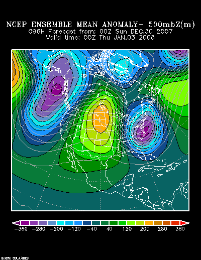
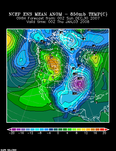
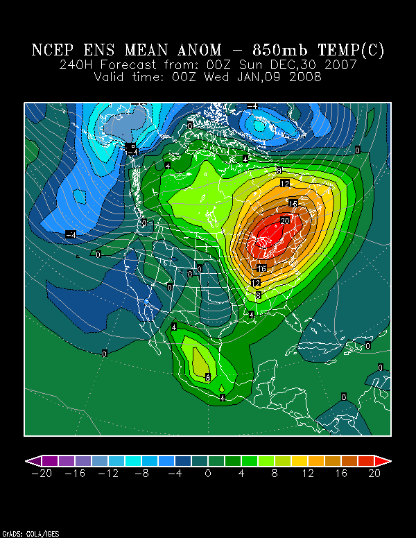
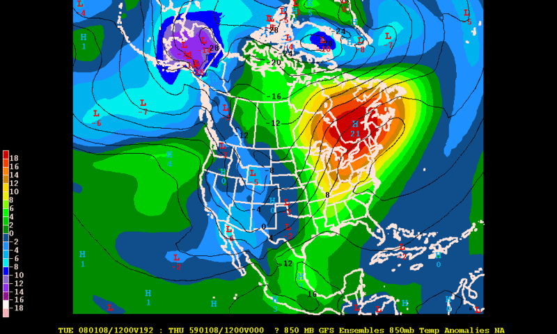
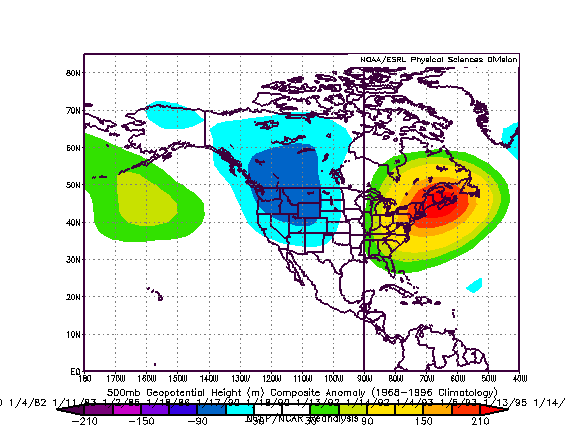
Such height anomalies would suggest maximum temperatures that could soar into the 60s as far north as southern New England and the 50s farther north. In fact, that forecast pattern fits well with a composite for all days in which the temperature reached or exceeded 58° in New York City in the 1950-2007 timeframe:

Image

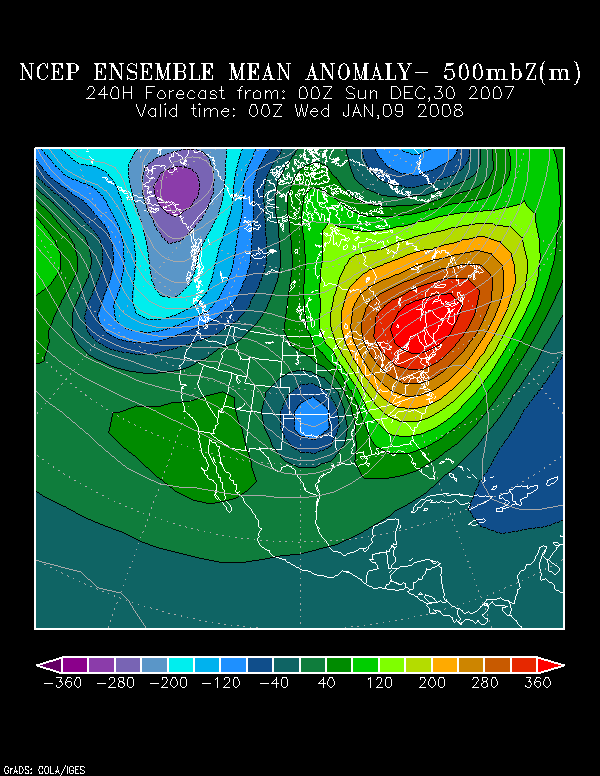
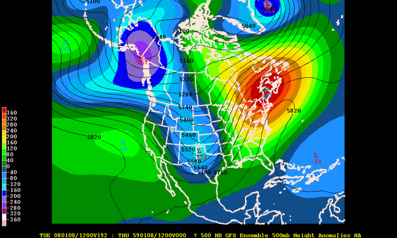
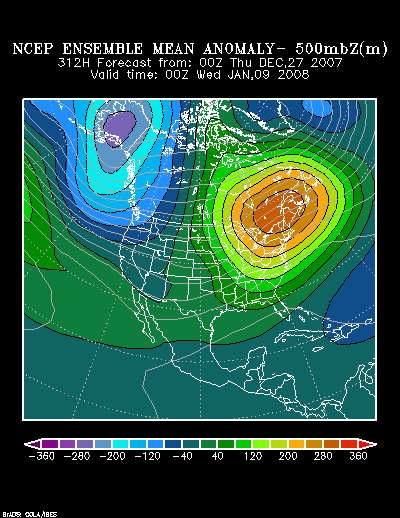
Furthermore, the magnitude of above normal 500 height anomalies has been increasing on the model guidance. To illustrate this, the 12z runs of the GFS ensembles have been forecasting peak above normal height anomalies as follows:

12/25 12z: 230 meters above normal
12/26 12z: 266 meters above normal
12/27 12z: 328 meters above normal
12/28 12z: 319 meters above normal

For purposes of perspective, the all-time January outbreaks of heat in 1950 and 2007 saw above normal height anomalies of 394 and 339 meters above normal respectively.

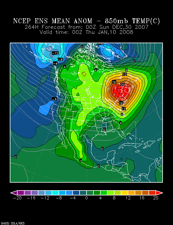
Hence, at least from this vantage point, a genuine period of excessive warmth appears likely during the January 8-15 timeframe, and it will likely be that warm spell that is the biggest weather story of the overall timeframe in question, if not January. Such warmth could well peak with highs in the 60s into southern New England, at least upper 50s in Boston, lower to middle 50s in such cities as Burlington, Concord, and Toronto, and upper 40s to around 50° in Montreal. Even higher temperatures are possible if there is meaningful sunshine.

Average Regional Temperature Anomalies:
Northeast: Much above normal
Mid-Atlantic: Much above normal
Southeast: Above normal
Great Lakes: Above to much above normal
Northern Plains: Above normal
Central Plains: Above normal
Southern Plains: Above normal
Pacific Northwest: Somewhat below normal to near normal
Southwest/Rest of West Coast: Near normal to somewhat above normal

Best Guess of Regional Temperature Anomalies (°F):
Northeast: +8° to +10°
Mid-Atlantic: +7° to +9°
Southeast: +2° to +4°
Great Lakes: +5 to +7°
Northern Plains: +3° to +5°
Central Plains: +2° to +4°
Southern Plains: +2° to +4°
Pacific Northwest: -2° to 0°
Southwest/Rest of West Coast: 0° to +2°

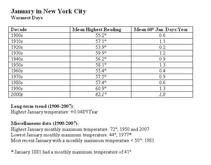
Historical Tidbit: January Warmth in New York City:

Image
0 likes   

User avatar
Cyclenall
Category 5
Category 5
Posts: 6665
Joined: Thu Jun 08, 2006 10:01 pm
Location: Ontario, Canada

#2 Postby Cyclenall » Fri Dec 28, 2007 6:37 pm

Did you see my post in the other topic that was about this? Did you just pick this up today or yesterday?

The 14-day trend is still showing huge warmth for the Greak Lakes area further into January. I wonder if TWN uses models to get this data?
0 likes   

User avatar
tropicana
Category 5
Category 5
Posts: 8056
Joined: Sat Sep 27, 2003 6:48 pm
Location: Niagara Falls, Ontario, Canada
Contact:

Re: January 8-15, 2008 Idea: Possible Incredible Warmth Ahead

#3 Postby tropicana » Sat Dec 29, 2007 7:49 pm

this is gonna be nice to look forward to, after next weeks' short but bitter cold snap.
0 likes   

donsutherland1
S2K Analyst
S2K Analyst
Posts: 2718
Joined: Mon Sep 15, 2003 8:49 pm
Location: New York

Re:

#4 Postby donsutherland1 » Sun Dec 30, 2007 1:06 am

Cyclenall,

I've actually been watching the ensemble guidance for almost a week and been very impressed with the blowtorch potential. I usually provide 10-17/18-day ideas at regular intervals and made the potential warmth a highlight of this forecast.
0 likes   

User avatar
Stephanie
S2K Supporter
S2K Supporter
Posts: 23843
Age: 62
Joined: Thu Feb 06, 2003 9:53 am
Location: Glassboro, NJ

Re: January 8-15, 2008 Idea: Possible Incredible Warmth Ahead

#5 Postby Stephanie » Sun Dec 30, 2007 11:55 am

While I welcome the warmth, I'm afraid of what this will do with the plants, etc. They are very hardy and have seen this happen before in other "January thaws", but it's almost ridiculous IMHO.

I want a good snowstorm or two and then spring. Will I get that? Probably not! :lol:
0 likes   

User avatar
Cyclenall
Category 5
Category 5
Posts: 6665
Joined: Thu Jun 08, 2006 10:01 pm
Location: Ontario, Canada

Re: Re:

#6 Postby Cyclenall » Sun Dec 30, 2007 2:37 pm

donsutherland1 wrote:Cyclenall,

I've actually been watching the ensemble guidance for almost a week and been very impressed with the blowtorch potential. I usually provide 10-17/18-day ideas at regular intervals and made the potential warmth a highlight of this forecast.

So is it still looking very likely in the guidance? I hope it gets freakishly warm and the flowers start coming out like last year :lol: . Then, another historic lake effect snow event to finish the winter before an early spring occurs.

The 14-day trend continues to show this and is a lot higher today then yesterday. Windsor could be experiencing +14C on January 8th :lol: . I wouldn't be surprised if there are thunderstorms again in January. At this rate, a normal winter is a thing of the past.
0 likes   

Scott Patterson
Category 2
Category 2
Posts: 796
Age: 50
Joined: Wed Mar 22, 2006 6:52 pm
Location: Near Craig Colorado
Contact:

Re: January 8-15, 2008 Idea: Possible Incredible Warmth Ahead

#7 Postby Scott Patterson » Sun Dec 30, 2007 2:46 pm

Please send some of that "Possible Incredible Warmth Ahead" out this way. We could use some. :wink:

http://forecast.weather.gov/MapClick.ph ... 107.55&e=1

Tonight: Snow likely, mainly before 11pm. Cloudy, with a low around -1. Wind chill values as low as -15. West wind between 10 and 15 mph, with gusts as high as 35 mph. Chance of precipitation is 60%. New snow accumulation of 1 to 2 inches possible.

Monday: Partly sunny, with a high near 12. Wind chill values as low as -20. West southwest wind between 10 and 15 mph.

Monday Night: Partly cloudy, with a low around -18. Wind chill values as low as -30. West southwest wind between 5 and 15 mph.

New Year's Day: Mostly sunny, with a high near 16. East southeast wind around 5 mph.

Tuesday Night: Partly cloudy, with a low around -16.

Wednesday: Mostly sunny, with a high near 24.

Wednesday Night: Partly cloudy, with a low around -7.
0 likes   

donsutherland1
S2K Analyst
S2K Analyst
Posts: 2718
Joined: Mon Sep 15, 2003 8:49 pm
Location: New York

#8 Postby donsutherland1 » Sun Dec 30, 2007 3:02 pm

For what it is worth, the 12/30/2007 0z GFS ensembles continue to herald potential historic warmth.

Animation of forecast 500 mb height anomalies (1/3/2008 0z - 1/11/2008 0z):
Image

Animation of forecast 850 mb temperature anomalies (1/3/2008 0z - 1/11/2008 0z):
Image

The cold that will be routed:

500 mb height anomalies forecast for 1/3 0z:
Image

850 mb temperature anomalies forecast for 1/3 0z:
Image

Note the area of 18°C (32.4°F) departures from normal.

The peak of potential historic warmth:

500 mb height anomalies forecast for 1/9 0z:
Image

850 mb temperature anomalies forecast for 1/9 0z:
Image

500 mb height anomalies forecast for 1/10 0z:
Image

850 mb temperature anomalies forecast for 1/10 0z:
Image

Note the areas of 20°C (36.0°F) and even 22° (39.6°F) departures from normal.
0 likes   

Ed Mahmoud

Re: January 8-15, 2008 Idea: Possible Incredible Warmth Ahead

#9 Postby Ed Mahmoud » Sun Dec 30, 2007 8:41 pm

10 day EC 500 mb shows a big ridge in the East, and the flow behind the mid-continent trough is zonal, from the Pacific. That would seem to support the GFS ensemble forecast of warmth in the East, and across the US

Image
0 likes   

User avatar
Sean in New Orleans
Category 5
Category 5
Posts: 1794
Joined: Thu Aug 28, 2003 7:26 pm
Location: New Orleans, LA 30.0N 90.0W
Contact:

#10 Postby Sean in New Orleans » Sun Dec 30, 2007 9:03 pm

Well, if this pans out, we all know that it will be followed by extreme cold. If I'm figuring right, that means, it will probably be arctic cold in New Orleans around Mardi Gras, which is early this year (Feb. 5).
0 likes   

Ed Mahmoud

Re:

#11 Postby Ed Mahmoud » Sun Dec 30, 2007 9:21 pm

Sean in New Orleans wrote:Well, if this pans out, we all know that it will be followed by extreme cold. If I'm figuring right, that means, it will probably be arctic cold in New Orleans around Mardi Gras, which is early this year (Feb. 5).


Maybe not. If it isn't going to snow anyway, I hope this weeks cold shot is a one and done thing, and we start an early Spring.
0 likes   

jinftl
Category 5
Category 5
Posts: 4312
Joined: Tue Aug 31, 2004 4:47 pm
Location: fort lauderdale, fl

Re: Re:

#12 Postby jinftl » Sun Dec 30, 2007 9:59 pm

Ed Mahmoud wrote:
Sean in New Orleans wrote:Well, if this pans out, we all know that it will be followed by extreme cold. If I'm figuring right, that means, it will probably be arctic cold in New Orleans around Mardi Gras, which is early this year (Feb. 5).


Maybe not. If it isn't going to snow anyway, I hope this weeks cold shot is a one and done thing, and we start an early Spring.


exactly...by that point we will be talking signs of Spring....seems like we always go from Christmas to Groundhog Day in 2 seconds.... guess the window of opportunity for sustained arctic air down south can be measured in weeks...much like the window of 90+ temps in Maine or Vermont!
0 likes   

User avatar
Extremeweatherguy
Category 5
Category 5
Posts: 11095
Joined: Mon Oct 10, 2005 8:13 pm
Location: Florida

#13 Postby Extremeweatherguy » Sun Dec 30, 2007 11:00 pm

February has featured many extreme cold events in years past. In fact, two of the greatest of all time (1895 and 1899) occurred in February. For my area of the country (Houston, TX) in particular, February is usually the month with the best potential for snowfall and other big cold events. Houston has seen 11 snow events since 1895, 5 ice events since 1960 and 9 extreme cold events (<15F) since 1894 during the month of February. Houston's longest freeze on record (123 hours) also occurred during the late January/early February time period and the second longest freeze (110 hours) occurred during mid February. If anything, February is actually one of the best months to potentially see arctic airmasses slip southward. As the northern jet begins to relax in February during these La Nina years, there is the potential that the southland (especially the southern plains) could see a pretty decent arctic blast. Will it happen for sure? no. But until winter is officially over (March 21st), no one should assume that early signs of spring or January warmth mean an end to winter, because as past experience has shown, that is rarely the case.

Once spring does officially arrive though, then I will be happy to take the warmth and get rid of the cold. By that point, I am usually sick of the chilly mornings and the snow threats that don't ever seem to deliver. I will likely be well into my "storm season" mode by March and ready for some good squall lines to hopefully race on through here. We still have a good 2-3 months to go before that though.
0 likes   

Ed Mahmoud

Re:

#14 Postby Ed Mahmoud » Sun Dec 30, 2007 11:04 pm

Extremeweatherguy wrote:February has featured many extreme cold events in years past. In fact, two of the greatest of all time (1895 and 1899) occurred in February. For my area of the country (Houston, TX) in particular, February is usually the month with the best potential for snowfall and other big cold events. Houston has seen 11 snow events since 1895, 5 ice events since 1960 and 9 extreme cold events (<15F) since 1894 during the month of February. Houston's longest freeze on record (123 hours) also occurred during the late January/early February time period and the second longest freeze (110 hours) occurred during mid February. If anything, February is actually one of the best months to potentially see arctic airmasses slip southward. As the northern jet begins to relax in February during these La Nina years, there is the potential that the southland (especially the southern plains) could see a pretty decent arctic blast. Will it happen for sure? no. But until winter is officially over (March 21st), no one should assume that early signs of spring or January warmth mean an end to winter, because as past experience has shown, that is rarely the case.

Once spring does officially arrive though, then I will be happy to take the warmth and get rid of the cold. By that point, I am usually sick of the chilly mornings and the snow threats that don't ever seem to deliver. I will likely be well into my "storm season" mode by March and ready for some good squall lines to hopefully race on through here. We still have a good 2-3 months to go before that though.


Spring like warmth may come with Spring like severe weather...
0 likes   

JBG
Tropical Storm
Tropical Storm
Posts: 146
Joined: Fri Apr 29, 2005 12:34 pm
Location: New York City area
Contact:

Re:

#15 Postby JBG » Sun Dec 30, 2007 11:23 pm

Extremeweatherguy wrote:February has featured many extreme cold events in years past. In fact, two of the greatest of all time (1895 and 1899) occurred in February.
New York City's record cold was February 9, 1934, -15F or about -24C. Most of New York's greatest snow events have occurred during February as well:
  1. The 2006 blizzard, 26.9 inches, all time record snow;
  2. Mayor Lindsay storm, February 1969;
  3. Major February 1967 storm;
  4. February 1978 Blizzard (strongest effects in Boston but NYC got over a foot);
  5. Presidents' Day Storms of 1979 and 2003; and last (that I personally remember) but certainly not least
  6. 1983 Megalopolis (sp) Blizzard
. Most of these were Kocin-Uccinelli Storms that affected most of the East Coast from Washington DC north (I think 1969 may have started further north than Washington and not sure if KU was reached for 2006 storm).

Exceptions to this "February Rule" were of course the January 1996 and December 26-27, 1947 storms, but February and March overall definitely "takes the cake" in NYC area. I wonder how La Nina plays into this, since only 1996 and 2006 blizzards were La Nina storms.
0 likes   

Ed Mahmoud

Re: January 8-15, 2008 Idea: Possible Incredible Warmth Ahead

#16 Postby Ed Mahmoud » Sun Dec 30, 2007 11:36 pm

Back when I lived on Long Island, I missed 5 days of school for the February 1978 snowstorm. And the Great South Bay backed up into the storm sewers, overflowing and discoloring the snow near all the storm drains.


Oh, that was wonderful. But about two weeks earlier, an unforcast (supposed to be snow turning to rain, and it never turned, about one foot worth) cancelled school, my parents let me sleep in, I awoke, and the snow outside the window was glorious!


Mind you, I was in eight grade, in Catholic school, when Catholic schools still had nuns, mean ones at that, usually, and snow days were gifts.


I think we might have had to make up some days that June, but I don't remember it.
0 likes   

JBG
Tropical Storm
Tropical Storm
Posts: 146
Joined: Fri Apr 29, 2005 12:34 pm
Location: New York City area
Contact:

Re: January 8-15, 2008 Idea: Possible Incredible Warmth Ahead

#17 Postby JBG » Mon Dec 31, 2007 12:30 am

Ed Mahmoud wrote:Oh, that was wonderful. But about two weeks earlier, an unforcast (supposed to be snow turning to rain, and it never turned, about one foot worth) cancelled school, my parents let me sleep in, I awoke, and the snow outside the window was glorious!
I was in Ithaca for that January 1978 storm, where the turnover never happened. Even Ithaca got walloped, but only about 8 inches worth.

We got a few quite cold flurries out of the great February 1978 storm.
0 likes   

User avatar
terstorm1012
S2K Supporter
S2K Supporter
Posts: 1314
Age: 43
Joined: Fri Sep 10, 2004 5:36 pm
Location: Millersburg, PA

Re: January 8-15, 2008 Idea: Possible Incredible Warmth Ahead

#18 Postby terstorm1012 » Mon Dec 31, 2007 10:00 am

Good---I need a break from the cold. I just hope it doesn't last too long like last year, because last February and March were absolutely misreable where I live.
0 likes   

donsutherland1
S2K Analyst
S2K Analyst
Posts: 2718
Joined: Mon Sep 15, 2003 8:49 pm
Location: New York

#19 Postby donsutherland1 » Mon Dec 31, 2007 2:41 pm

For purposes of updating what the ensembles continue to depict as a potential historic bout of warmth, the following are the 500 mb height anomalies and 850 mb temperatures forecast for 192 hours. The 12z ensemble suite now takes the 500 mb height anomalies to 407 meters above normal. For purposes of comparison, the all-time January outbreaks of heat in 1950 and 2007 saw above normal height anomalies of 394 and 339 meters above normal respectively.


500 mb height anomalies for 192 hours:
Image

850 mb temperature anomalies for 192 hours:
Image
0 likes   

User avatar
Cyclenall
Category 5
Category 5
Posts: 6665
Joined: Thu Jun 08, 2006 10:01 pm
Location: Ontario, Canada

#20 Postby Cyclenall » Mon Dec 31, 2007 3:56 pm

TWN 14-day trend continues to show this very strongly so this is good. So how high of a % will many records be broken on these dates?

Checking the warm spot of Ontario, Windsor's 14-day trend shows temps. of +14C for both Jan.8 and Jan.9. Here is today's timeline for Windsor:

Jan.4 : +2.5C
Jan.5 : +3C
Jan.6 : +9C
Jan.7 : +10.5C
Jan.8 : +14C
Jan.9 : +14C
Jan.10 : +11C
Jan.11 : +7C
Jan.12 : +4C
Jan.13 : +7C
Jan.14 : +5C

This is nothing short of astonishing.
0 likes   


Return to “Winter Weather”

Who is online

Users browsing this forum: No registered users and 87 guests