January 8-15, 2008 Idea: Possible Incredible Warmth Ahead

Winter Weather Discussion

Moderator: S2k Moderators

Forum rules

The posts in this forum are NOT official forecast and should not be used as such. They are just the opinion of the poster and may or may not be backed by sound meteorological data. They are NOT endorsed by any professional institution or STORM2K.

Help Support Storm2K
Message
Author
donsutherland1
S2K Analyst
S2K Analyst
Posts: 2718
Joined: Mon Sep 15, 2003 8:49 pm
Location: New York

#21 Postby donsutherland1 » Mon Dec 31, 2007 10:53 pm

January has seen a number of notable outbreaks of warmth in the eastern United States. Three such outbreaks occurred in 1932, 1950, and 2007. During those years, temperatures soared into the 70s in the Middle Atlantic region and typically the 60s into southern New England. In 1950, Boston saw the mercury exceed 70°.

January 1932:

Whence and why this warm weather in January? Trite summer greetings that were supposed to be safely moth-balled and hibernating have been heard on every hand this week. Announcement of flowers blooming in the backyard, speculation as to whether swelling buds will ruin fruit prospects alternate with jovial remarks about getting out linen suits and limbering up the electric fans. Perspiring days to mid-January are even more unusual for Washington than snow-blockaded presidential inaugurations in March.

Source: “Tropical Washington,” The Washington Post January 16, 1932.

Highest temperatures for select cities:
Boston: 69°, 1/14
New York City: 70°, 1/14
Philadelphia: 73°, 1/14
Washington, DC (DCA): 77°, 1/15

January 1950:

Another flower at the Brooklyn Botanic Garden yesterday took advantage of the absence of wintry weather. A species of Adonis, with flowers, somewhat like a marsh marigold’s, joined the snowdrops in bloom along the main walk.

Source: “Adonis Flowers Come Out Weeks Early in Brooklyn,” The New York Times, January 24, 1950

Highest temperatures for select cities:
Boston: 72°, 1/26
New York City: 72°, 1/26
Philadelphia: 74°, 1/26
Washington, DC (DCA): 79°, 1/26

January 2007:

Around the city, there were signs of a season out of whack, like cherry blossoms in Central Park…

Source: Anthony Ramirez, “With Mild Winter, the City Revisits Fall Fashion and the Record Books,” The New York Times, January 6, 2007.

Highest temperatures for select cities:
Boston: 69°, 1/6
New York City: 72°, 1/6
Philadelphia: 73°, 1/6
Washington, DC (DCA): 73°, 1/6

Image
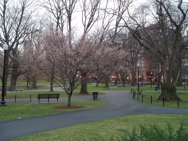
Boston Public Garden (January 13, 2007)
0 likes   

donsutherland1
S2K Analyst
S2K Analyst
Posts: 2718
Joined: Mon Sep 15, 2003 8:49 pm
Location: New York

#22 Postby donsutherland1 » Tue Jan 01, 2008 12:41 am

Per a quick look at the 1/1/2008 0z NCEP ensemble suite, 500 mb height anomalies now peak at 425 meters above normal (192 hours) and 850 mb temperature anomalies reach as high as 23°C (41.4°F) at 204 hours.

500 mb height anomalies at 192 hours:
Image

850 mb temperature anomalies at 192 hours:
Image

850 mb temperature anomalies at 204 hours:
Image

Happy New Year to all!
0 likes   

JBG
Tropical Storm
Tropical Storm
Posts: 146
Joined: Fri Apr 29, 2005 12:34 pm
Location: New York City area
Contact:

Re: January 8-15, 2008 Idea: Possible Incredible Warmth Ahead

#23 Postby JBG » Tue Jan 01, 2008 1:08 am

How warm does this make the temperatures on the Ungava Peninsula (tundra part of Quebec)?
0 likes   

Ed Mahmoud

Re: January 8-15, 2008 Idea: Possible Incredible Warmth Ahead

#24 Postby Ed Mahmoud » Tue Jan 01, 2008 1:34 am

Good thing tomorrow's outdoor NHL game in Buffalo is tomorrow and not next week.


Would need one heck of a fridge system to keep the rink frozen with temps near 15ºC
0 likes   

pawxguy
Tropical Low
Tropical Low
Posts: 48
Joined: Fri Apr 09, 2004 6:43 pm
Location: Carbon Co. PA

#25 Postby pawxguy » Tue Jan 01, 2008 10:02 am

These warm periods are what help me mentally get through the cold of the winter. We'll see how much of a westerly wind component accompanies this east coast warmth. Otherwise the coastal plains are stuck in the maritime airmass from DC northward. On the flipside we'll see if Minneapolis or Green Bay or Chicago get a nice snow event around 1/9-1/10 time period. Exciting wx ahead, no doubt. :wink:
0 likes   

Ed Mahmoud

Re:

#26 Postby Ed Mahmoud » Tue Jan 01, 2008 10:21 am

pawxguy wrote:These warm periods are what help me mentally get through the cold of the winter. We'll see how much of a westerly wind component accompanies this east coast warmth. Otherwise the coastal plains are stuck in the maritime airmass from DC northward. On the flipside we'll see if Minneapolis or Green Bay or Chicago get a nice snow event around 1/9-1/10 time period. Exciting wx ahead, no doubt. :wink:


Spring warmth with a January strength jet stream- I'm getting excited about severe weather next week.
0 likes   

User avatar
terstorm1012
S2K Supporter
S2K Supporter
Posts: 1314
Age: 43
Joined: Fri Sep 10, 2004 5:36 pm
Location: Millersburg, PA

#27 Postby terstorm1012 » Tue Jan 01, 2008 6:57 pm

Any word on how long this may last?

Larry Cosgrove suggests after the 12th winter returns with a vengeance.
0 likes   

User avatar
Category 5
Category 5
Category 5
Posts: 10074
Age: 35
Joined: Sun Feb 11, 2007 10:00 pm
Location: New Brunswick, NJ
Contact:

Re: January 8-15, 2008 Idea: Possible Incredible Warmth Ahead

#28 Postby Category 5 » Tue Jan 01, 2008 7:13 pm

So basically....

Same as last year.
0 likes   

JBG
Tropical Storm
Tropical Storm
Posts: 146
Joined: Fri Apr 29, 2005 12:34 pm
Location: New York City area
Contact:

Re: January 8-15, 2008 Idea: Possible Incredible Warmth Ahead

#29 Postby JBG » Wed Jan 02, 2008 9:56 am

The long-term, 14 day forecast for Niagara (link) is showing what looks like an incredible cold snap starting around January 15, 2008. Thoughts?
0 likes   

User avatar
Ptarmigan
Category 5
Category 5
Posts: 5313
Joined: Wed Aug 16, 2006 9:06 pm

Re: January 8-15, 2008 Idea: Possible Incredible Warmth Ahead

#30 Postby Ptarmigan » Wed Jan 02, 2008 3:07 pm

Interesting analysis, Don Sutherland. It is suppose to warm up this week for SE Texas. This warming trend could bring about severe weather outbreak next week though. I tend to notice before big freezes happen, there is warmth, sometimes in record territory. I remember that when I lived in Austin in February of 2003.

Most snow tends to fall in February, around Valentine's Day interestingly. The biggest snowfall was on February 14-15 1895 where 20" inches fell. As far as I know, it was not an El Nino winter, but a Neutral Winter. I suspect it had to do with Pacific North American (PNA), North Atlantic Oscillation (NAO), Pacific Decadal Oscillation (PDO), and Arctic Oscillation (AO). If 20" of snow was to fall today, it would totally shut down the region and it would be big news. The next largest snow event was on February 12, 1960, where 4.4" fell.

WRC-Houston Snow
0 likes   

User avatar
lrak
S2K Supporter
S2K Supporter
Posts: 1770
Age: 58
Joined: Thu Jun 21, 2007 2:48 pm
Location: Corpus Christi, TX

Re: January 8-15, 2008 Idea: Possible Incredible Warmth Ahead

#31 Postby lrak » Wed Jan 02, 2008 5:57 pm

So with all this warmth up North, where will the cold go?

Is that a big blue bulls eye on Texas?

Winter needs to end NOW. :D
0 likes   

JonathanBelles
Professional-Met
Professional-Met
Posts: 11430
Age: 34
Joined: Sat Dec 24, 2005 9:00 pm
Location: School: Florida State University (Tallahassee, FL) Home: St. Petersburg, Florida
Contact:

#32 Postby JonathanBelles » Wed Jan 02, 2008 6:02 pm

well, i guess, since you all kindly shared the cold with us down here, we are gonna return the favor.

Thanks for the cold.
0 likes   

User avatar
srainhoutx
S2K Supporter
S2K Supporter
Posts: 6919
Age: 67
Joined: Sun Jan 14, 2007 11:34 am
Location: Haywood County, NC
Contact:

Re: January 8-15, 2008 Idea: Possible Incredible Warmth Ahead

#33 Postby srainhoutx » Wed Jan 02, 2008 10:26 pm

Don,
Any thoughts on the model runs concerning Mid January. CPC sure hinted that a pattern change may be on the horizon.
Snipet:

8-14 DAY OUTLOOK FOR JAN 10 - 16 2008: THE ATMOSPHERIC CIRCULATION FOR THE WEEK 2 FORECAST PERIOD IS EXPECTED TO UNDERGO RAPID CHANGES COMPARED TO THE 6-10 DAY FORECAST PATTERN. AS A RESULT, SIGNIFICANT DIFFERENCES ARE APPARENT BETWEEN MODEL SOLUTIONS. THE CANADIAN ENSEMBLE MEAN HOLDS ON TO A PATTERN WHICH IS SIMILAR TO THAT PREDICTED FOR DAYS 6-10, BUT THE OTHER MODEL SOLUTIONS DIFFER IN SEVERAL WAYS. FOR EXAMPLE, THERE IS A NOTICEABLE SPLIT IN THE BROAD WEST COAST TROUGH, WITH A CONCENTRATION OF BELOW NORMAL 500-HPA HEIGHTS OVER WESTERN ALASKA AND THE BERING SEA, AND ANOTHER CONCENTRATION OF BELOW NORMAL HEIGHTS OVER THE SOUTHWESTERN CONUS. THERE IS ALSO A MODERATE RIDGE FORECAST OVER THE EASTERN GULF OF ALASKA AND INTO WESTERN CANADA. THERE IS SOME INDECISION ON THE PART OF MOST MODELS AS TO WHERE TO PLACE THE UNUSUALLY STRONG RIDGE OVER THE SOUTHERN MARITIMES REGION IN THE PRECEDING 6-10 DAY PERIOD. IF THE RIDGE REMAINS IN THIS SAME LOCATION, THE EASTERN CONUS WOULD STAY RELATIVELY WARM, BUT IF, AS SOME MODEL RUNS SHOW, THIS RIDGE RELOCATES TO NORTHERN HUDSON BAY, VERY COLD CONTINENTAL AIR MASSES WOULD BE GENERATED. SOON THEREAFTER, ARCTIC AIR MAY STREAM SOUTHWARD ACROSS THE BORDER INTO THE CENTRAL (AND POSSIBLY EASTERN) CONUS. HOPEFULLY, TOMORROWS MODEL RUNS WILL ALLOW US TO BETTER ASSESS THE LIKELIHOOD OF THIS POSSIBILITY.


http://www.cpc.ncep.noaa.gov/products/p ... xus06.html
0 likes   

User avatar
Stephanie
S2K Supporter
S2K Supporter
Posts: 23843
Age: 62
Joined: Thu Feb 06, 2003 9:53 am
Location: Glassboro, NJ

Re: January 8-15, 2008 Idea: Possible Incredible Warmth Ahead

#34 Postby Stephanie » Thu Jan 03, 2008 9:27 pm

Stephanie wrote:While I welcome the warmth, I'm afraid of what this will do with the plants, etc. They are very hardy and have seen this happen before in other "January thaws", but it's almost ridiculous IMHO.

I want a good snowstorm or two and then spring. Will I get that? Probably not! :lol:


UNCLE!!! :eek:

Crap! Two days of deep freeze and wind and I'm ready for that warmth!

Yeah, I know, I'm a wimp. :lol:
0 likes   

User avatar
Cyclenall
Category 5
Category 5
Posts: 6665
Joined: Thu Jun 08, 2006 10:01 pm
Location: Ontario, Canada

#35 Postby Cyclenall » Mon Jan 07, 2008 3:35 pm

I'm getting thunderstorms in southern Ontario. It's January 7th, and this is the 3rd time in a row that each year for me had a thunderstorm in the middle of winter (2006, 2007, and now 2008!!). I never remember this ever. The storms also hit upper MI.
0 likes   

JBG
Tropical Storm
Tropical Storm
Posts: 146
Joined: Fri Apr 29, 2005 12:34 pm
Location: New York City area
Contact:

Re:

#36 Postby JBG » Mon Jan 07, 2008 3:57 pm

Cyclenall wrote:I'm getting thunderstorms in southern Ontario. It's January 7th, and this is the 3rd time in a row that each year for me had a thunderstorm in the middle of winter (2006, 2007, and now 2008!!). I never remember this ever. The storms also hit upper MI.
I remember "thundersnow" during snowstorms in the NYC area on December 26, 1969, January 1, 1971, February 11 (or so), 1983, and January 6, 1996. There are a few others as well.
0 likes   

User avatar
Cyclenall
Category 5
Category 5
Posts: 6665
Joined: Thu Jun 08, 2006 10:01 pm
Location: Ontario, Canada

Re: Re:

#37 Postby Cyclenall » Mon Jan 07, 2008 4:59 pm

JBG wrote:
Cyclenall wrote:I'm getting thunderstorms in southern Ontario. It's January 7th, and this is the 3rd time in a row that each year for me had a thunderstorm in the middle of winter (2006, 2007, and now 2008!!). I never remember this ever. The storms also hit upper MI.
I remember "thundersnow" during snowstorms in the NYC area on December 26, 1969, January 1, 1971, February 11 (or so), 1983, and January 6, 1996. There are a few others as well.

This is just a normal T-storm though but thundersnow is even more rare then that.

TWN just reported that it is +16C (15.5C to be exact) in Windsor Ontario right now!! :eek: That should be a new record right there (It is, I just checked) along with many others today.
0 likes   

JBG
Tropical Storm
Tropical Storm
Posts: 146
Joined: Fri Apr 29, 2005 12:34 pm
Location: New York City area
Contact:

Re: Re:

#38 Postby JBG » Mon Jan 07, 2008 6:24 pm

Cyclenall wrote: This is just a normal T-storm though but thundersnow is even more rare then that.
Windsor is inland, so conventional thunderstorms would be more common than thunder-snow. On the I-95 corridor "thunder-snow" is a bit more common during the winter inasmuch as the cold ocean tends to suppress convective events during cold frontal passage. Even a "southwest" wind will often have enough cold ocean mixed in to cut down on normal thunderstorms until mid-May.
0 likes   


Return to “Winter Weather”

Who is online

Users browsing this forum: Google [Bot] and 59 guests