
-Springfield, MO Tornado Outbreak, Miss Valley/G'Lakes
Moderator: S2k Moderators
Forum rules

The posts in this forum are NOT official forecast and should not be used as such. They are just the opinion of the poster and may or may not be backed by sound meteorological data. They are NOT endorsed by any professional institution or STORM2K.
-
Weatherfreak14

- Category 5

- Posts: 1381
- Joined: Sat Sep 24, 2005 3:40 pm
- Location: Beaufort, SC
- Contact:
-
Ed Mahmoud
Re: Holy not quite 1/8/07 TX/-Springfield, MO Tornado Outbreak,
Bunkertor wrote:Ed Mahmoud wrote:Bunkertor wrote:This is f***ing strange.
Well, when DonaldSutherland1 started showing pretty consistent ensemble runs showing abnormal warm temperatures in the Central/Eastern US, and saw the model projections of the big system(s) that produced the California mega-blizzard, especially the European from about 8 days ago, I had a feeling a Spring like outbreak was in the offing...
Maps now look like in April.
Do you mean the user European or the snow event over here ?
ECMWF model showed a very strong trough and a LLJ over 30 m/s at 850 mb
0 likes
-
Weatherfreak14
- Category 5
- Posts: 1381
- Joined: Sat Sep 24, 2005 3:40 pm
- Location: Beaufort, SC
- Contact:


-
CrazyC83
- Professional-Met

- Posts: 34315
- Joined: Tue Mar 07, 2006 11:57 pm
- Location: Deep South, for the first time!
MESOSCALE DISCUSSION 0017
NWS STORM PREDICTION CENTER NORMAN OK
0509 PM CST MON JAN 07 2008
AREAS AFFECTED...LOWER MI
CONCERNING...SEVERE POTENTIAL...WATCH POSSIBLE
VALID 072309Z - 080045Z
CLOSELY MONITORING FOR THE POSSIBILITY OF A WATCH ISSUANCE ACROSS
SOUTHERN LOWER MI...AS SOME RISK EXISTS FOR ISOLATED
TORNADOES/DAMAGING WINDS AND PERHAPS SEVERE HAIL EARLY THIS EVENING.
AS A WARM FRONT CONTINUES TO DEVELOP NORTHWARD ACROSS CENTRAL LOWER
MI...AN UNSEASONABLY WARM/MOIST AIRMASS CONTINUES TO SPREAD
NORTHEASTWARD ACROSS THE MID MISSISSIPPI VALLEY INTO LOWER MI.
WITHIN THIS VERY HIGH SHEAR/MARGINAL INSTABILITY REGIME...SUPERCELL
WITH TORNADIC HISTORY ACROSS FAR SOUTHEAST WI HAS BEGUN TO CROSS
SOUTHWEST LAKE MICHIGAN EAST OF RACINE. WITH CONVECTIVE COVERAGE
LIKELY TO INCREASE ACROSS SOUTHERN LOWER MI EARLY THIS EVENING...RUC
SOUNDINGS SUGGEST STORMS WILL BE NEAR SURFACE BASED WHERE
TEMPERATURES ARE IN THE UPPER 50S F OR HIGHER...ALTHOUGH STRONG LOW
LEVEL WINDS/TURBULENT MIXING WILL BE A COMPENSATING FACTOR EVEN WITH
SLIGHTLY COOLER TEMPERATURES. STRONG VERTICAL SHEAR...HIGHLIGHTED BY
IMPRESSIVE 300-500 M2/S2 0-1 KM...WILL CONDITIONALLY SUPPORT
ROTATING STORMS WITH A RISK FOR ISOLATED TORNADOES/DAMAGING WINDS.
SHORT TERM TRENDS WILL CONTINUE TO BE CLOSELY MONITORED ACROSS LOWER
MI.
..GUYER.. 01/07/2008
ATTN...WFO...DTX...IWX...GRR...
43548656 43698520 43178403 41938431 41798524 41858628
42558640
0 likes
Re: Holy not quite 1/8/07 TX/-Springfield, MO Tornado Outbreak,
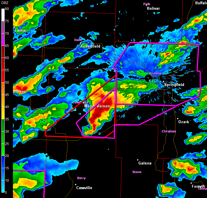
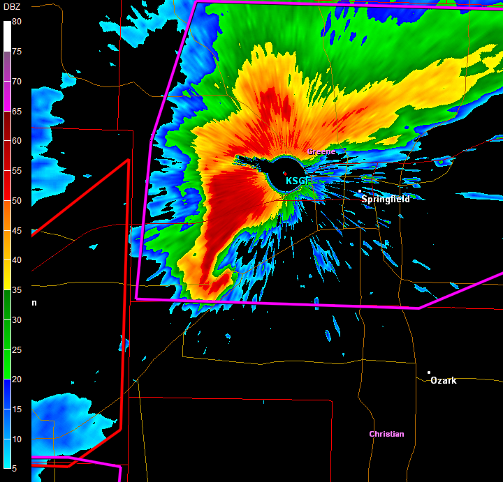
Watch out Springfield.
BULLETIN - EAS ACTIVATION REQUESTED
TORNADO WARNING
NATIONAL WEATHER SERVICE SPRINGFIELD MO
526 PM CST MON JAN 7 2008
THE NATIONAL WEATHER SERVICE IN SPRINGFIELD HAS ISSUED A
* TORNADO WARNING FOR...
GREENE COUNTY IN SOUTHWEST MISSOURI...
* UNTIL 630 PM CST.
* AT 521 PM CST...NATIONAL WEATHER SERVICE DOPPLER RADAR INDICATED A
SEVERE THUNDERSTORM CAPABLE OF PRODUCING A TORNADO. ALSO...A
TORNADO HAS BEEN OBSERVED BY SEVERAL SPOTTERS OVER SOUTHEAST
LAWRENCE COUNTY. THIS VERY DANGEROUS STORM WAS LOCATED NEAR
VERONA...OR 6 MILES EAST OF MONETT...MOVING NORTHEAST AT 45 MPH.
ANYONE IN OR NEAR THE CITY OF SPRINGFIELD SHOULD CONSIDER TAKING
COVER.
* THIS TORNADIC STORM WILL BE NEAR...
REPUBLIC BY 550 PM CST.
BATTLEFIELD BY 600 PM CST.
7 MILES SOUTHEAST OF WILLARD BY 605 PM CST.
SPRINGFIELD BY 610 PM CST.
STRAFFORD BY 620 PM CST.
FAIR GROVE BY 625 PM CST.
0 likes

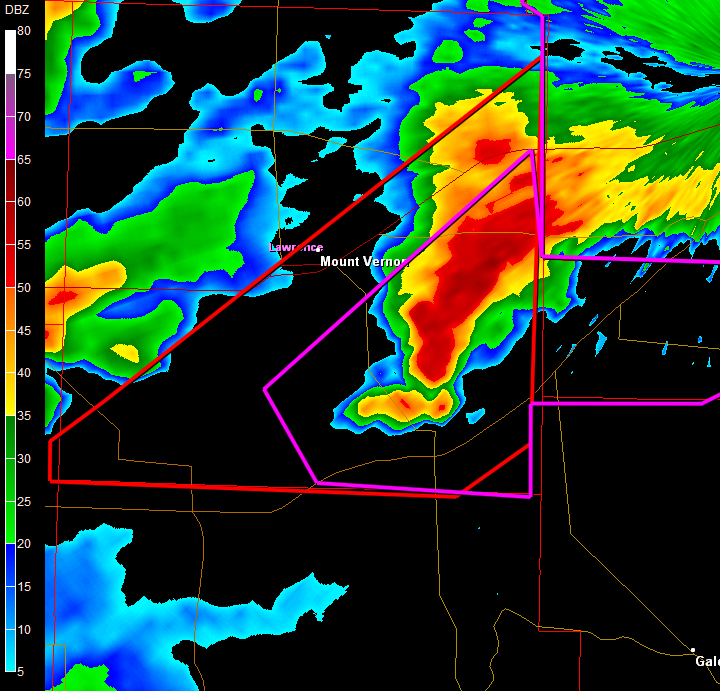
Re: Holy not quite 1/8/07 TX/-Springfield, MO Tornado Outbreak,
Are there reports out if that are long trackers ? Maps do look so...
Last edited by Bunkertor on Mon Jan 07, 2008 6:34 pm, edited 1 time in total.
0 likes
-
Weatherfreak14
- Category 5
- Posts: 1381
- Joined: Sat Sep 24, 2005 3:40 pm
- Location: Beaufort, SC
- Contact:
Re:
RL3AO wrote:The cell in SW MO is heading directly for Springfield. About 30 miles away.
EDIT: Confirmed tornado by law enforcement with the cell.

0 likes
-
CrazyC83
- Professional-Met
- Posts: 34315
- Joined: Tue Mar 07, 2006 11:57 pm
- Location: Deep South, for the first time!
New Tornado Watch - SW Michigan/N Indiana.
Much of the area currently has NO tornado risk...there will surely be major changes at 0100Z.
Much of the area currently has NO tornado risk...there will surely be major changes at 0100Z.
Last edited by CrazyC83 on Mon Jan 07, 2008 7:00 pm, edited 1 time in total.
0 likes
Re: Holy not quite 1/8/07 TX/-Springfield, MO Tornado Outbreak,
AT 555 PM CST...NATIONAL WEATHER SERVICE DOPPLER RADAR CONTINUED TO
TRACK A CONFIRMED TORNADO WEST OF REPUBLIC...OR TWO MILES NORTH OF
BILLINGS...MOVING NORTHEAST AT 45 MPH. ANYONE IN OR NEAR REPUBLIC
AND SPRINGFIELD SHOULD TAKE COVER IMMEDIATELY.
TRACK A CONFIRMED TORNADO WEST OF REPUBLIC...OR TWO MILES NORTH OF
BILLINGS...MOVING NORTHEAST AT 45 MPH. ANYONE IN OR NEAR REPUBLIC
AND SPRINGFIELD SHOULD TAKE COVER IMMEDIATELY.
0 likes
Return to “USA & Caribbean Weather”
Who is online
Users browsing this forum: Brent, Google [Bot] and 74 guests