-Springfield, MO Tornado Outbreak, Miss Valley/G'Lakes
Moderator: S2k Moderators
Forum rules

The posts in this forum are NOT official forecast and should not be used as such. They are just the opinion of the poster and may or may not be backed by sound meteorological data. They are NOT endorsed by any professional institution or STORM2K.

-
MiamiensisWx
I think the title should be changed... this outbreak is affecting Illinois, Missouri, Kansas, Oklahoma, and other areas. It is NOT restricted to Springfield!!!
There are several TOR warnings in eastern OK and other portions of MO...
There are several TOR warnings in eastern OK and other portions of MO...
Last edited by MiamiensisWx on Mon Jan 07, 2008 8:34 pm, edited 1 time in total.
0 likes
-
brunota2003

- S2K Supporter

- Posts: 9476
- Age: 35
- Joined: Sat Jul 30, 2005 9:56 pm
- Location: Stanton, KY...formerly Havelock, NC
- Contact:
Re: Re:
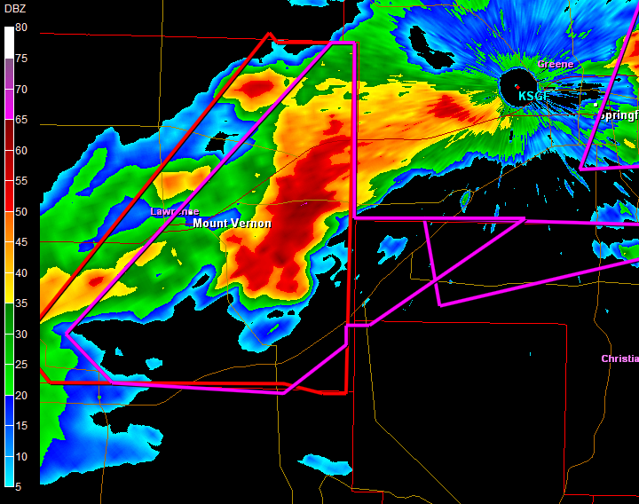
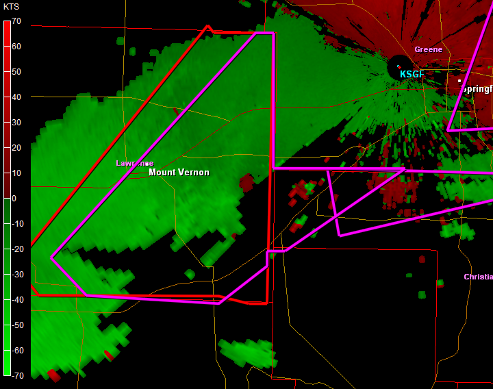
CrazyC83 wrote:brunota2003 wrote:Uh...looking at the storm track for the one ESE of Mount Veron, is going to be a VERY close call for KSGF (Springfield, MO NWS Office)
Who backs them up, St. Louis?
Honestly, I do not know...but the track of the storm looks like it'll be just a tad to the north of the radar site, meaning any shift to the east by a hair, puts it right over them. Currently have a TOR warning for that cell (rotation only...for the moment). But it looks to be taking on more of a hook shape...Anyone else see it?
0 likes
-
CrazyC83
- Professional-Met

- Posts: 34315
- Joined: Tue Mar 07, 2006 11:57 pm
- Location: Deep South, for the first time!
Re: Re:
brunota2003 wrote:CrazyC83 wrote:brunota2003 wrote:Uh...looking at the storm track for the one ESE of Mount Veron, is going to be a VERY close call for KSGF (Springfield, MO NWS Office)
Who backs them up, St. Louis?
Honestly, I do not know...but the track of the storm looks like it'll be just a tad to the north of the radar site, meaning any shift to the east by a hair, puts it right over them. Currently have a TOR warning for that cell (rotation only...for the moment). But it looks to be taking on more of a hook shape...Anyone else see it?
I'd evacuate the office and go on backup mode there...
0 likes
-
CrazyC83
- Professional-Met
- Posts: 34315
- Joined: Tue Mar 07, 2006 11:57 pm
- Location: Deep South, for the first time!
Re:
MiamiensisWx wrote:I think the title should be changed... this outbreak is affecting Illinois, Missouri, Kansas, Oklahoma, and other areas. It is NOT restricted to Springfield!!!
There are several TOR warnings in eastern OK and other portions of MO...
I agree!
0 likes
-
brunota2003
- S2K Supporter
- Posts: 9476
- Age: 35
- Joined: Sat Jul 30, 2005 9:56 pm
- Location: Stanton, KY...formerly Havelock, NC
- Contact:
MOC077-080200-
/O.CON.KSGF.TO.W.0015.000000T0000Z-080108T0200Z/
GREENE MO-
732 PM CST MON JAN 7 2008
...A TORNADO WARNING REMAINS IN EFFECT UNTIL 800 PM CST FOR GREENE
COUNTY...
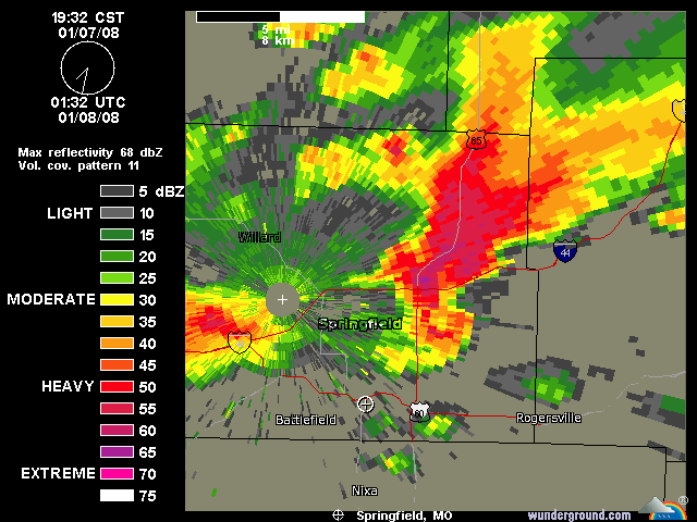
...TORNADO EMERGENCY STILL IN EFFECT FOR EASTERN SPRINGFIELD AND
EASTERN GREENE COUNTY...
AT 727 PM CST...NATIONAL WEATHER SERVICE DOPPLER RADAR AND STORM
SPOTTERS CONTINUED TO TRACK A LARGE AND EXTREMELY DANGEROUS TORNADO
OVER SPRINGFIELD...MOVING NORTHEAST AT 45 MPH.
/O.CON.KSGF.TO.W.0015.000000T0000Z-080108T0200Z/
GREENE MO-
732 PM CST MON JAN 7 2008
...A TORNADO WARNING REMAINS IN EFFECT UNTIL 800 PM CST FOR GREENE
COUNTY...
...TORNADO EMERGENCY STILL IN EFFECT FOR EASTERN SPRINGFIELD AND
EASTERN GREENE COUNTY...
AT 727 PM CST...NATIONAL WEATHER SERVICE DOPPLER RADAR AND STORM
SPOTTERS CONTINUED TO TRACK A LARGE AND EXTREMELY DANGEROUS TORNADO
OVER SPRINGFIELD...MOVING NORTHEAST AT 45 MPH.
0 likes

-
brunota2003
- S2K Supporter
- Posts: 9476
- Age: 35
- Joined: Sat Jul 30, 2005 9:56 pm
- Location: Stanton, KY...formerly Havelock, NC
- Contact:
Re: Re:
CrazyC83 wrote:I'd evacuate the office and go on backup mode there...
If they are like the NWS office here at Newport, NC...their break room is literally a bunker...so they'll stay up as long as they can, then get into the room.
0 likes
-
MiamiensisWx
THIRD TORNADIC CELL MOVING INTO SPRINGFIELD - THIS IS A NEW WARNING
BULLETIN - EAS ACTIVATION REQUESTED
TORNADO WARNING
NATIONAL WEATHER SERVICE SPRINGFIELD MO
736 PM CST MON JAN 7 2008
THE NATIONAL WEATHER SERVICE IN SPRINGFIELD HAS ISSUED A
* TORNADO WARNING FOR...
GREENE COUNTY IN SOUTHWEST MISSOURI...
* UNTIL 845 PM CST.
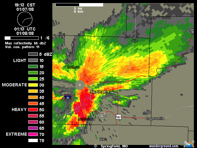
* AT 732 PM CST...NATIONAL WEATHER SERVICE DOPPLER RADAR INDICATED A
SEVERE THUNDERSTORM CAPABLE OF PRODUCING A TORNADO. THIS VERY
DANGEROUS STORM WAS LOCATED NEAR MARIONVILLE...OR 7 MILES NORTHEAST
OF AURORA...MOVING NORTHEAST AT 45 MPH.
* THIS TORNADIC STORM WILL BE NEAR...
REPUBLIC BY 745 PM CST.
8 MILES NORTHWEST OF BATTLEFIELD BY 750 PM CST.
WILLARD AND 7 MILES NORTHWEST OF SPRINGFIELD BY 800 PM CST.
9 MILES NORTHWEST OF STRAFFORD BY 810 PM CST.
FAIR GROVE BY 815 PM CST.
THE TOWNS OF BOIS D'ARC...GLIDEWELL...EBENEZER AND BASSVILLE ARE ALSO
IN THE PATH OF THIS TORNADIC STORM.
IN ADDITION TO A TORNADO...THIS STORM IS CAPABLE OF PRODUCING LARGE
DAMAGING HAIL UP TO GOLF BALL SIZE.
UNBELIEVABLE!
BULLETIN - EAS ACTIVATION REQUESTED
TORNADO WARNING
NATIONAL WEATHER SERVICE SPRINGFIELD MO
736 PM CST MON JAN 7 2008
THE NATIONAL WEATHER SERVICE IN SPRINGFIELD HAS ISSUED A
* TORNADO WARNING FOR...
GREENE COUNTY IN SOUTHWEST MISSOURI...
* UNTIL 845 PM CST.
* AT 732 PM CST...NATIONAL WEATHER SERVICE DOPPLER RADAR INDICATED A
SEVERE THUNDERSTORM CAPABLE OF PRODUCING A TORNADO. THIS VERY
DANGEROUS STORM WAS LOCATED NEAR MARIONVILLE...OR 7 MILES NORTHEAST
OF AURORA...MOVING NORTHEAST AT 45 MPH.
* THIS TORNADIC STORM WILL BE NEAR...
REPUBLIC BY 745 PM CST.
8 MILES NORTHWEST OF BATTLEFIELD BY 750 PM CST.
WILLARD AND 7 MILES NORTHWEST OF SPRINGFIELD BY 800 PM CST.
9 MILES NORTHWEST OF STRAFFORD BY 810 PM CST.
FAIR GROVE BY 815 PM CST.
THE TOWNS OF BOIS D'ARC...GLIDEWELL...EBENEZER AND BASSVILLE ARE ALSO
IN THE PATH OF THIS TORNADIC STORM.
IN ADDITION TO A TORNADO...THIS STORM IS CAPABLE OF PRODUCING LARGE
DAMAGING HAIL UP TO GOLF BALL SIZE.
UNBELIEVABLE!
0 likes
-
Category 5

- Category 5

- Posts: 10074
- Age: 36
- Joined: Sun Feb 11, 2007 10:00 pm
- Location: New Brunswick, NJ
- Contact:
-
Ed Mahmoud
Re: Holy not quite 1/8/07 TX/-Springfield, MO Tornado Outbreak,
MiamiensisWx wrote:It's absolutely APPALLING and DISGUSTING that more people have not been participating in this thread. This is a dangerous situation. Severe wx affects the South and Gulf, too. It seems like most posters only think the tropics are important...
Obviously, I'm not referring to those who have posted in this thread. Keep up the good work and coverage, everyone!
On the one hand, a tropical cyclone can affect a lot more people, but there is almost always warning time of a day or more in the modern era. Conditions that may be favorable enough to issue a watch usually only has a few hours of lead time, and an actual tornado rarely gives more than 30 minutes notice, frequently much less.
0 likes
-
MiamiensisWx
-
Ed Mahmoud
Re: Holy not quite 1/8/07 TX/-Springfield, MO Tornado Outbreak,
I added the SGF this morning when it became obvious that was where the severe weather risk was centered. I'll go edit the thread title to Mississippi Valley/Great Lakes.
0 likes
-
MiamiensisWx
-
Category 5
- Category 5
- Posts: 10074
- Age: 36
- Joined: Sun Feb 11, 2007 10:00 pm
- Location: New Brunswick, NJ
- Contact:
-
brunota2003
- S2K Supporter
- Posts: 9476
- Age: 35
- Joined: Sat Jul 30, 2005 9:56 pm
- Location: Stanton, KY...formerly Havelock, NC
- Contact:
Return to “USA & Caribbean Weather”
Who is online
Users browsing this forum: No registered users and 126 guests