Storm Forecast
Valid: Tue 08 Jan 2008 06:00 to Wed 09 Jan 2008 06:00 UTC
Issued: Mon 07 Jan 2008 20:28
Forecaster: TUSCHY
SYNOPSIS
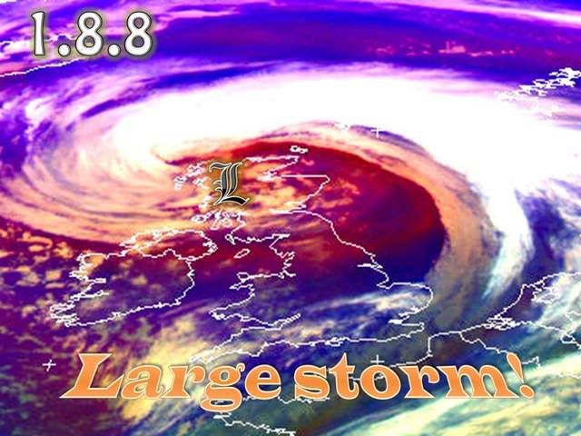
Numerous disturbances rotate around a far southward stretching branch of the polar vortex, affecting Ireland, Scotland and United Kingdom during the next 24 hours.
Weak pressure gradients prevail for the rest of Europe and hence atmospheric stratification will stay too stable for deep convection.
DISCUSSION
...Ireland, United Kingdom and Scotland...
No doubt...the main player is an intense depression, approaching Ireland from the west during the early afternoon hours and reaching Scotland during the end of the forecast period.
Despite the fact that the path of this depression is quite consistent in the model pool, strength is by far not conform and this hampers the chance to highlight special areas of augmented interest that far out.
GFS produced up to 8hPa surface pressure fluctuations although most of the runs favored a central pressure below 980hPa. The tilt of this depression will stay negative while crossing the area.
A word to the standard deviations at 500 hPa geopotential height fields, which are quite low with some uncertainties regarding degree of amplification, but otherwise GFS seems to have a good handling on this system.
The time - frame of interest will be between about 18Z and 00Z for United Kingdom and 21Z - 06Z for Ireland, Scotland and northern UK.
...18Z-00Z...
A well structured trough axis approaches UK from the SW with a diffluent mid-/upper-level streamline pattern in place. At lower levels, GFS hints on a more substantial pressure fall with a nice meridional aligned surface low pressure channel, crossing UK from the SW between aforementioned period.
A compact vort max is forecast to cross mainly west / northwest UK after 18Z as cold front at lower-levels also advances eastwards and finally an approaching speed max at 300hPa helps to produce healthy UL divergence values in its left exit region, also crossing central and northern UK around 21Z.
Forcing and environmental support at all levels is therefore present and the main question will be how robust instability will be.
A lot depends on the final structure and placement of the main depression and run-to-run consistency is not good. BL moisture advection is not bad with mixing ratio reaching 6g/kg, but the strength of the depression and hence the advection of colder mid-/level air in its southern quadrant to the east is still uncertain .
In this forecast we reflect the mean of the past few model runs of GFS, indicating a broad area of at least low-end instability release, covering UK.
Shear at lower levels is quite strong and despite a weak directional shear, reflected in low helicity values, the concern arises for a few tornadoes. Like during the past few events, an organized line of showers / thunderstorms ( LEWP-pattern ) along the eastward racing cold front can be anticipated and in addition to the isolated tornado threat wind gusts, matching our criterion can be expected, too.
We therefore decided to issue a broad level-1 area and we included most parts of it in a thunderstorm area as EL temperatures indicate a fair chance for deep convection.
The threat should diminish after midnight from the SW.
...21Z - 06Z...
A serious wind storm threat could arise during the night hours, dependant on the final position and strength of the depression.
Some wrap-around moisture and atop quite cold mid-levels should support low-end instability release, mainly confined to offshore areas.
Shallow and possibly non-electrified convection could affect N-Ireland and Scotland / NW - UK during the night hours. Again we have to consider the run-to-run consistency but there is an incisive signal of impressive 30-40m/s winds at 850hPa with gusts, exceeding 35-45m/s.
We went with a level-1 as there is no sign of an embedded area with more robust convective activity. Each stronger convective segment could easily produce severe - destructive wind gusts.
It will be hard to verify convective wind events in such a powerful kinematic environment and hence no higher probabilities will be issued for now.
Again...this broad level-1 area is composed of 2 different anticipated severe weather modes ( an isolated tornado / severe wind gust risk over UK and a potential widespread severe (straight-line ) wind event with embedded convection ) and lasts for 2 different periods!
We included Scotland in the header as a slight northward shift of the depression would place the strongest winds into southern Scotland.
http://estofex.org/
sat image
http://www.sat24.com/frame.php?html=view&country=eu